Paper:
Community Classification Based on Landform Distribution and Flood Hazard Characteristics in Candaba Municipality, Pampanga River Basin, Philippines
Naoko Nagumo*,†, Miho Ohara**, and Patricia Ann Jaranilla-Sanchez***

*International Centre for Water Hazard and Risk Management (ICHARM), Public Works Research Institute (PWRI)
1-6 Minamihara, Tsukuba, Ibaraki 305-8516, Japan
†Corresponding author
**Interfaculty Initiative in Information Studies, The University of Tokyo
Tokyo, Japan
***School of Environmental Science and Management, University of the Philippines Los Baños
Los Baños, Philippines

The Candaba Swamp, situated in the lower reaches of the Pampanga River on Luzon Island, is important for maintaining the local ecosystem and storing floodwaters. Analyses using an original land classification map and satellite images describing the situation of recent flood inundation show that severe flooding in the Candaba Swamp mainly results from concentrated flood flows from eastern tributary rivers and the Cabiao Floodway onto lower landform surfaces. Communities in Candaba municipality, which includes most of the swamp, are divided into four groups based on flood hazard characteristics identified from landform distributions and recent flood inundation conditions. In the most flood-prone group, located in the central swamp, the average floor height of living spaces above the ground is higher compared to the other groups. However, in two-story houses, the most common house type in the group, the flood inundation height reached an average of 1.8 ft above the floor level during the worst flood event in the past five years. These households also tend to have longer residency and show less intention to relocate, likely because flood inundation in the swamp brings both risks and certain benefits. Implementing flood countermeasures, including those that maximize the functions of the Candaba Swamp, should consider these flood hazard characteristics and local living practices.
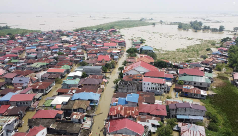
Flooding of Barangay San Agustin, Candaba Municipality in September 2022
- [1] United Nations Office for Disaster Risk Reduction (UNDRR), “Ecosystem-based disaster risk reduction,” United Nations, 2020.
- [2] U. Nehren et al., “Towards a typology of nature-based solutions for disaster risk reduction,” Nature-Based Solutions, Vol.3, Article No.100057, 2023. https://doi.org/10.1016/j.nbsj.2023.100057
- [3] P. Menéndez, I. J. Losada, S. Torres-Ortega, S. Narayan, and M. W. Beck, “The global flood protection benefits of mangroves,” Scientific Reports, Vol.10, Article No.4404, 2020. https://doi.org/10.1038/s41598-020-61136-6
- [4] T. Ichinose, J. Ishii, and I. Imoto, “The Watarase Retarding Basin—A historical example of ecosystem-based disaster risk reduction in Japan,” M. Mukherjee and R. Shaw (Eds.), “ Ecosystem-Based Disaster and Climate Resilience: Integration of Blue-Green Infrastructure in Sustainable Development,” pp. 441-464, Springer, 2021. https://doi.org/10.1007/978-981-16-4815-1_20
- [5] Y. Wu, J. Sun, B. Hu, G. Zhang, and A. N. Rousseau, “Wetland-based solutions against extreme flood and severe drought: Efficiency evaluation of risk mitigation,” Climate Risk Management, Vol.40, Article No.100505, 2023. https://doi.org/10.1016/j.crm.2023.100505
- [6] Forest and Natural Environment Group, Global Environment Department, Japan International Cooperation Agency (JICA), “Ecosystem-based disaster risk reduction (Eco-DRR), JICA’s Eco-DRR cooperation in developing countries.” https://www.jica.go.jp/english/our_work/thematic_issues/disaster/c8h0vm0000bvqtv9-att/Ecosystem-basedDisasterRiskReduction.pdf [Accessed October 25, 2025]
- [7] R. A. E. Acierto, T. Ushiyama, P. A. Jaranilla-Sanchez, and M. Ohara, “Downscaled climate projections for rainfall extremes and drought in Pampanga and Pasig-Marikina-Laguna basins,” J. Disaster Res., Vol.21, No.2, pp. 287-298, 2026. https://doi.org/10.20965/jdr.2026.p0287
- [8] N. Nagumo and H. Sawano, “Land classification and flood characteristics of the Pampanga River basin, central Luzon, Philippines,” J. of Geography, Vol.125, No.5, pp. 699-716, 2016. https://doi.org/10.5026/jgeography.125.699
- [9] M. A. Henson, “The Province of Pampanga and its towns (A.D. 1300–1962),” Angeles, Philippines, 1963.
- [10] Pampanga River Basin Flood Forcasting and Warning Center, “Pampanga River basin flood event: Typhoon Ulysses (international name: Vamco) November 10 to 17, 2020,” PRFFWC Post-Flood Report 2020, 2021.
- [11] National Disaster Risk Reduction and Management Council, The Philippines, “Sitrep No.29 re preparedness measures and effects for Typhoon ‘Ulysses’ (I.N. Vamco),” 2021.
- [12] Pampanga River Basin Flood Forcasting and Warning Center, “Pampanga River basin flood events: Tropical cyclone “Karding” (international name: Noru) flood watch coverage: September 24 to October 01, 2022; and Tropical cyclone “Paeng” (international name: Nalgae) flood watch coverage: October 28 to November 01, 2022,” PRFFWC Post-Flood Report 2022, 2023.
- [13] M. Oya, “Applied geomorphology for mitigation of natural hazards,” Springer, 2002.
- [14] Z. Pang et al., “Survey on flood impacts and countermeasures in Candaba Municipality, Pampanga Province, Republic of the Philippines,” Research Survey Reports in Information Studies, Interfaculty Initiative in Information Studies, The University of Tokyo, Vol.41, pp. 107-224, 2025 (in Japanese). https://doi.org/10.15083/0002013518
- [15] https://github.com/microsoft/IdMyPhBuildingFootprints [Accessed October 25, 2025]
- [16] A. M. Juarez-Lucas, K. M. Kibler, M. Ohara, and T. Sayama, “Benefits of flood-prone land use and the role of coping capacity, Candaba floodplains, Philippines,” Natural Hazards, Vol.84, No.3, pp. 2243-2264, 2016. https://doi.org/10.1007/s11069-016-2551-2
This article is published under a Creative Commons Attribution-NoDerivatives 4.0 Internationa License.