
Paper:
Observable Point Cloud Maps for Wide-Area Self-Localization
Kazuma Yagi, Shugo Nishimura, Yu Okita, Photchara Ratsamee
 , Kazuyo Tsuzuki
, Seiji Aoyagi
, and Yasushi Mae†
, Kazuyo Tsuzuki
, Seiji Aoyagi
, and Yasushi Mae†
Kansai University
3-3-35 Yamate-cho, Suita, Osaka 564-8680, Japan
†Corresponding author

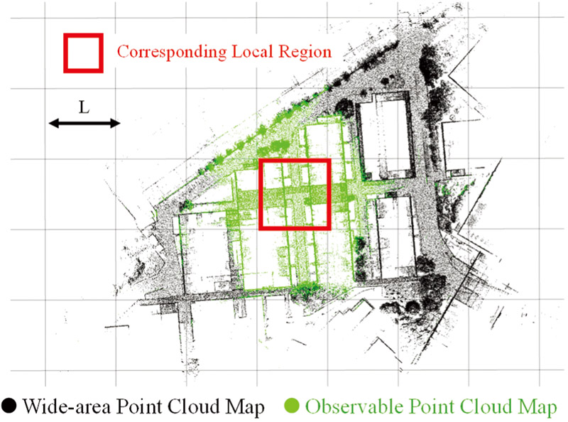
Self-localization using a pre-constructed point cloud map is effective even in global navigation satellite system-denied settings, such as indoor environments and areas adjacent to buildings. In wide-area environments, however, the amount of map data becomes enormous, increasing storage and computational costs. This study proposes a method to partition a wide-area point cloud map into local regions and construct observable point cloud maps by extracting only the points observable from virtual viewpoints placed within each region. Each observable point cloud map contains only the point cloud that contributes to self-localization in the corresponding local region. During the self-localization process, the robot dynamically switches the observable point cloud maps according to its current local region. Self-localization accuracy and computational costs are evaluated using both the wide-area point cloud map and proposed observable point cloud maps. Additionally, the localization contribution per point is used to quantify the effectiveness of the retained map points. The results show the dynamic switching of observable point cloud maps enables memory-efficient self-localization while maintaining localization accuracy comparable to that of the wide-area point cloud map.
Observable point cloud map
- [1] S. Suga, H. Ishii, T. Takahashi, M. Suzuki, K. Tsuzuki, Y. Mae, and S. Aoyagi, “Autonomous navigation of mobile robot based on visual information and GPS—Path planning by semantic segmentation with the A* algorithm and obstacle avoidance by kernel density estimation—,” J. Robot. Mechatron., Vol.37, No.6, pp. 1283-1292, 2025. https://doi.org/10.20965/jrm.2025.p1283
- [2] S. Kurebayashi, T. Tomizawa, and S. Tarao, “Game-engine-based 3D simulation of mobile robot and its application to autonomous navigation in physical environments,” J. Robot. Mechatron., Vol.37, No.6, pp. 1314-1326, 2025. https://doi.org/10.20965/jrm.2025.p1314
- [3] F. Massa, L. Bonamini, A. Settimi, L. Pallottino, and D. Caporale, “LiDAR-based GNSS denied localization for autonomous racing cars,” Sensors, Vol.20, No.14, Article No.3992, 2020. https://doi.org/10.3390/s20143992
- [4] K. Koide, S. Oishi, M. Yokozuka, and A. Banno, “Tightly coupled range inertial localization on a 3D prior map based on sliding window factor graph optimization,” 2024 IEEE Int. Conf. on Robotics and Automation (ICRA), pp. 1745-1751, 2024. https://doi.org/10.1109/icra57147.2024.10611195
- [5] X. Zheng and J. Zhu, “Efficient LiDAR odometry for autonomous driving,” IEEE Robotics and Automation Letters, Vol.6, No.4, pp. 8458-8465, 2021. https://doi.org/10.1109/LRA.2021.3110372
- [6] X. Chen, I. Vizzo, T. Labe, J. Behley, and C. Stachniss, “Range image-based LiDAR localization for autonomous vehicles,” 2021 IEEE Int. Conf. on Robotics and Automation (ICRA), pp. 5802-5808, 2021. https://doi.org/10.1109/icra48506.2021.9561335
- [7] K. Koide, M. Yokozuka, S. Oishi, and A. Banno, “Voxelized GICP for Fast and Accurate 3D Point Cloud Registration,” 2021 IEEE Int. Conf. on Robotics and Automation (ICRA), pp. 11054-11059, 2021. https://doi.org/10.1109/icra48506.2021.9560835
- [8] L. Yang, H. Ma, Z. Nie, H. Zhang, Z. Wang, and C. Wang, “3D LiDAR point cloud registration based on IMU preintegration in coal mine roadways,” Sensors, Vol.23, No.7, Article No.3473, 2023. https://doi.org/10.3390/s23073473
- [9] J. Wen, J. Tang, H. Liu, C. Qian, and X. Fan, “Real-Time Scan-to-Map Matching Localization System Based on Lightweight Pre-Built Occupancy High-Definition Map,” Remote Sensing, Vol.15, No.3, Article No.595, 2023. https://doi.org/10.3390/rs15030595
- [10] S. Aoki, K. Ikeda, and T. Oishi, “Global localization for 3D point cloud scan matching using branch-and-bound algorithm,” arXiv preprint, arXiv:2310.10023, 2023. https://doi.org/10.48550/arXiv.2310.10023
- [11] H. Yin, Y. Wang, L. Tang, X. Ding, S. Huang, and R. Xiong, “3D LiDAR map compression for efficient localization on resource constrained vehicles,” IEEE Trans. on Intelligent Transportation Systems, Vol.22, No.2, pp. 837-852, 2021. https://doi.org/10.1109/tits.2019.2961120
- [12] M.-F. Chang, W. Dong, J. Mangelson, M. Kaess, and S. Lucey, “Map compressibility assessment for LiDAR registration,” 2021 IEEE/RSJ Int. Conf. on Intelligent Robots and Systems (IROS), pp. 5560-5567, 2021. https://doi.org/10.1109/iros51168.2021.9636789
- [13] S. Lu, C. Han, and H. Yang, “Efficient large-scale point cloud geometry compression,” Sensors, Vol.25, No.5, Article No.1325, 2025. https://doi.org/10.3390/s25051325
- [14] K. Yagi, S. Nishimura, T. Matsunaga, K. Tsuzuki, S. Aoyagi, and Y. Mae, “Observable point cloud filtering from travel path for self-localization in wide-area environments,” J. Robot. Mechatron., Vol.37, No.6, pp. 1355-1364, 2025. https://doi.org/10.20965/jrm.2025.p1355
- [15] K. Zhang, S.-C. Chen, D. Whitman, M.-L. Shyu, J. Yan, and C. Zhang, “A progressive morphological filter for removing nonground measurements from airborne LIDAR data,” IEEE Trans. on Geoscience and Remote Sensing, Vol.41, No.4, pp. 872-882, 2003. https://doi.org/10.1109/tgrs.2003.810682
- [16] S. Katz, A. Tal, and R. Basri, “Direct visibility of point sets,” ACM Trans. on Graphics, Vol.26, No.3, Article No.24, 2007. https://doi.org/10.1145/1276377.1276407
- [17] K. Koide, M. Yokozuka, S. Oishi, and A. Banno, “GLIM: 3D range-inertial localization and mapping with GPU-accelerated scan matching factors,” Robotics and Autonomous Systems, Vol.179, Article No.104750, 2024. https://doi.org/10.1016/j.robot.2024.104750
- [18] P. Biber and W. Strasser, “The normal distributions transform: A new approach to laser scan matching,” 2003 IEEE/RSJ Int. Conf. on Intelligent Robots and Systems (IROS 2003), Vol.3, pp. 2743-2748, 2003. https://doi.org/10.1109/iros.2003.1249285
- [19] M. Magnusson, “The three-dimensional normal-distributions transform—An efficient representation for registration, surface analysis, and loop detection,” Ph.D. thesis, Örebro University, 2009.
- [20] K. Koide, koide3/ndt_omp. https://github.com/koide3/ndt_omp [Accessed November 18, 2025]
This article is published under a Creative Commons Attribution-NoDerivatives 4.0 Internationa License.