
Survey Report:
Evacuation Behavior in the Absence of Ground Shaking: A Survey Report on the 2025 Kamchatka Far-Field Tsunami in Shingu City, Japan
Nanami Hasegawa†
 and Tomoyuki Takabatake
Kindai University
3-4-1 Kowakae, Higashiosaka, Osaka 577-8502, Japan
†Corresponding author

This study investigated residents’ evacuation behavior in Shingu City, Wakayama Prefecture, following the far-field tsunami generated by the 2025 Kamchatka Peninsula earthquake. Using a web-based questionnaire survey (N=283), the relationship between residents’ spatial risk perception and evacuation actions in the absence of ground motion was analyzed. The results revealed that official information, specifically Tsunami Advisories, Warnings, and Evacuation Orders, served as the primary trigger for 81% of evacuees, confirming that information interpretation dictates behavior during far-field tsunamis. The evacuation rates of residents who perceived themselves to be inside the estimated inundation zone were significantly higher than those for residents outside the zone. However, spatial perception did not significantly affect evacuation timing or methods. Notably, the phased issuance of warnings contributed to a wide dispersion of departure times, effectively preventing traffic congestion despite high private car usage. Conversely, the decision to return home heavily depended on subjective judgment and social cues rather than official clearance, contrasting with near-field events, where physical cues are clearer. These findings underscore the importance of risk communication strategies that not only initiate evacuation but also sustain protective behavior, preventing premature returns driven by an overestimation of safety in the absence of visible physical cues.
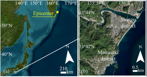
Study area and earthquake epicenter
1. Introduction
On July 30, 2025, at 08:24 JST (UTC+9), a moment magnitude (\(\mathrm{M}_{\mathrm{w}}\)) 8.8 earthquake occurred off the eastern coast of the Kamchatka Peninsula, Russia 1. The tsunami generated by this event propagated across the Pacific Ocean, triggering Tsunami Advisories and Warnings along a wide stretch of Japan’s Pacific coast. In many affected areas, residents did not experience strong ground shaking but were nevertheless required to make evacuation decisions based solely on official information, such as Tsunami Advisories, Warnings, and Evacuation Orders.
Tsunami evacuation behavior has been extensively studied, particularly in the context of near-field events, where strong ground motion and visible environmental changes often serve as immediate and intuitive triggers for evacuation 2,3,4,5,6,7. For instance, Takabatake et al. 8 reported that during the 2018 Sunda Strait tsunami, many residents initiated evacuation based on direct environmental cues, such as approaching seawater or loud sounds from the sea. In such situations, physical sensations directly reinforce risk perception, prompting rapid behavioral responses. In contrast, far-field tsunamis present a unique challenge: without ground motion or physical signs, residents must rely on indirect information, such as official warnings and social communication. This reliance creates ambiguity regarding urgency, forcing residents to construct their risk perception without directly confirming the threat.
Several studies have reported distinct behavioral patterns during far-field tsunami events 9,10. For instance, during the 2011 Tohoku earthquake tsunami, a far-field event for the US West Coast, the California Coastal Commission 11 reported that some residents who did not feel the ground shaking underestimated the danger. Consequently, a subset of residents reportedly visited the coastline to observe the waves or engage in surfing activities after receiving official notifications. These results suggest that evacuation behavior during far-field tsunamis is shaped not only by official warnings but also by residents’ subjective interpretation of risk when physical evidence is scarce.
During this interpretative process, residents’ perceived self-location—specifically, whether they identify themselves as being inside the estimated inundation zone, outside the zone, or are uncertain of their status, is likely critical not only to evacuation decision-making but also to subsequent evacuation behavior. However, while such relationships are generally expected in tsunami evacuation, empirical evidence systematically examining how differences in perceived self-location are associated with evacuation rates and behavioral patterns remains limited, particularly in the context of far-field tsunamis where residents must rely primarily on indirect information.
Against this background, this study presents a survey report on evacuation behavior during the far-field tsunami associated with the 2025 Kamchatka Peninsula earthquake, focusing on Shingu City, Wakayama Prefecture, Japan. Using a web-based questionnaire survey, this study examines how residents’ perceived self-location (inside, outside, or uncertain relative to the estimated inundation zone) influences evacuation decisions and subsequent behavioral patterns, including evacuation rates, initiation timing, evacuation methods, and return behavior. By documenting this case in detail, this report aims to provide empirical insights into decision-making under far-field tsunami conditions and contribute to the accumulation of observational evidence necessary for improving tsunami risk communication and evacuation guidance.
2. Methodology
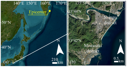
Source: Esri, Vantor, Earthstar Geographics, and the GIS User Community.
Fig. 1. (a) Location of the epicenter (yellow dot) and Shingu. (b) Aerial view of the target coastal areas.
2.1. Study Area
This study focuses on Shingu City, Wakayama Prefecture, Japan, for two primary reasons. First, it is expected to experience substantial tsunami inundation in the event of the Nankai Trough earthquake 12, making it a critical field for understanding tsunami evacuation readiness. Second, a comprehensive partnership agreement between Shingu City and Kindai University, which facilitated rapid cooperation with local authorities, ensured the practical feasibility of the study. Additionally, the presence of Kindai University Shingu Junior and Senior High School allowed for an effective distribution channel of the surveys to local households.
Geographically, Shingu City comprises coastal urban districts (Shingu and Miwasaki districts) and inland mountainous regions. This study specifically targeted residents living in the coastal urban districts, which are directly exposed to tsunami risks (Fig. 1). As Shingu is located approximately 2,800 km from the epicenter, residents did not experience marked ground motion on the day of the event (July 25, 2025). Following the earthquake, a Tsunami Advisory was issued at 08:37, upgraded to a Tsunami Warning at 09:40, and an Evacuation Order was issued at 10:51. Thus, Shingu represents a case where residents were required to make evacuation decisions based on phased information without the physical cue of ground shaking, making it suitable for examining behavioral responses to a far-field tsunami.
2.2. Questionnaire Survey
The authors administered a web-based questionnaire survey targeting residents aged 20 and over living in the coastal urban districts of Shingu City. Recruitment notices containing a QR code were (1) mailed by the Shingu City Hall to 2,000 households randomly selected from the Basic Resident Register within the coastal urban districts and (2) distributed to the guardians (parents) of all 473 students enrolled at Kindai University Shingu Junior and Senior High School. Respondents accessed a Google Form via the QR code or URL to complete the survey online. The survey period was from October 31 to November 17, 2025. Although the survey was distributed on a household basis, individual responses were requested if multiple eligible voters resided in a single household. Regarding the sample population, although the municipal mail strictly targeted the urban districts, the school distribution may have included households in mountainous areas or overlapped with the municipal mail recipients. These potential overlaps prevent a strict response rate calculation. However, using the primary random sample of 2,000 households as a baseline denominator, the 339 collected responses correspond to a gross recovery rate of approximately 17.0%.
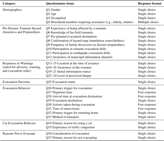
The questionnaire consisted of 37 items categorized into seven sections: Demographics (Q1–Q4); Pre-Disaster Tsunami Hazard Awareness and Preparedness (Q5–Q12); Responses to Warnings (Q13–Q24); Evacuation Decision (Q25); Evacuation Behavior (Q26–Q33); Car Evacuation Behavior (Q34 and Q35); and Reasons Not to Evacuate (Q36 and Q37). Notably, in the Responses to Warnings section, respondents were asked to report their location, awareness, information sources, and risk perception for Tsunami Advisory, Tsunami Warning, and Evacuation Order phases (Table 1). Questions about specific behaviors (e.g., car evacuation) were asked only when applicable. Invalid responses were excluded, resulting in 283 valid responses out of 339 collected (valid response rate: 83.5%). Notably, this paper focuses on demographics and evacuation behaviors (Q26–Q33) to highlight responses specific to far-field tsunamis. A detailed summary of the response distributions for survey questions not fully presented in the main text is provided in the table in Appendix A.
Table 1. Structure and items of the questionnaire survey.
2.3. Analytical Approach
In addition to descriptive statistics, chi-square tests were conducted to examine the association between respondents’ perceived location at the time of the Tsunami Warning and their evacuation behavior (Q26–Q33). Although the survey collected information for the Advisory, Warning, and Evacuation Order phases, the analysis focuses on the Tsunami Warning phase. This focus is based on previous studies (e.g., Hasegawa et al. 13), which have indicated that the escalation to a Warning constitutes a critical psychological threshold and serves as the primary trigger for evacuation actions. For the analysis, respondents were classified into three groups based on their self-reported location: (1) inside the estimated inundation zone, (2) outside the zone, and (3) uncertain of their status. The inundation zone reference was based on the hazard map 12. Notably, this hazard map assumes a worst-case scenario with a maximum tsunami height of approximately 14 m (Nankai Trough hazard map), which differs substantially from the actual observed height of approximately 0.5 m in this far-field event. However, because specific hazard maps for far-field tsunamis are not widely established or recognized by residents, their evacuation decisions should primarily be governed by their awareness of this hazard map. Therefore, this study adopts this zoning to classify areas based on residents’ relative risk perception—distinguishing between those who perceive themselves to be in a high- versus low-risk area.
Statistical analyses were performed using statistical software (BellCurve for Excel 4.10, Social Survey Research Information Co., Ltd., Tokyo, Japan).
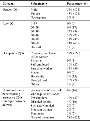
Table 2. Demographic characteristics of respondents (\(N=283\)).
3. Results and Discussion
3.1. Demographics
Table 2 summarizes the demographic characteristics of the respondents. The gender distribution was 54% male and 43% female. Compared to the 2020 Census of the area (54% female) 14, males were slightly overrepresented in this survey. Further, the proportion of elderly respondents (60s and over 70s) was lower than that in the census data (which reports 15% for 60–69, and 29% for over 70), likely due to the web-based nature of the survey method. Additionally, the distribution of invitations through middle and high schools may have influenced the age composition of the respondents, contributing to the high proportion of the respondents in their 40s (25%) and 50s (31%), who likely included parents of students. Regarding occupation, company employees / office workers accounted for the majority (59%). Notably, 22% of respondents reported having household members requiring assistance during evacuation (vulnerable people), with preschoolers being the most common category (10%).
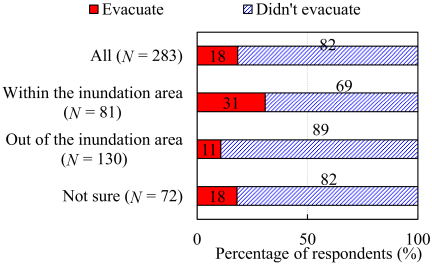
Fig. 2. Evacuation rates based on perceived location relative to the inundation zone (Q25) (\(p<0.01\)) (\(N=283\)).
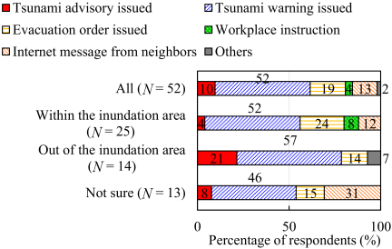
Fig. 3. Primary triggers for initiating evacuation (Q26) (\(N=52\)).
3.2. Evacuation Decision and Initiation
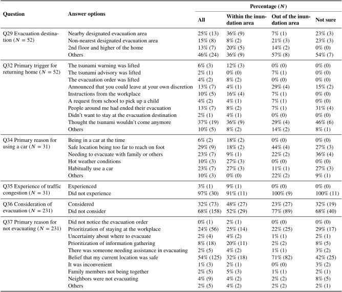
Figure 2 shows the evacuation implementation status (Q25). Overall, 82% of respondents reported that they “Did not evacuate,” indicating a relatively low evacuation rate. This trend aligns with the Cabinet Office survey 15 conducted in other regions in Japan, suggesting a common pattern of low evacuation compliance during far-field tsunamis. However, as this overall value includes residents living outside the estimated inundation zone, it may underestimate the actual response within higher-risk areas. A chi-square test revealed a significant relationship between perceived location relative to the estimated inundation zone and evacuation decision (\(p<0.01\)). Specifically, the evacuation rate was substantially higher among residents who perceived themselves to be within the inundation zone (31%) compared to those outside the zone (11%) and the overall value (18%). This demonstrates that even in the absence of ground motion, spatial risk perception based on hazard maps strongly influences decision-making. Regarding evacuation destinations (Q29), evacuees selected a range of destinations rather than relying exclusively on designated evacuation sites. The most common category was non-designated evacuation locations, including mountains, nearby high ground, relatives’ homes, and commercial facilities (46%), followed by the nearest designated evacuation site (25%), a non-nearest designated evacuation site (15%), and the second floor or higher of the respondent’s home (13%). No statistically significant difference in destination choice was observed based on the respondents’ perceived location relative to the inundation zone. Among non-evacuees, 32% “Considered evacuating” (Q36), suggesting they were not entirely unaware of the danger. Regardless of location, the most common reasons for not evacuating (Q37) were “Perceived safety of current location” (54%) and “Work-related constraints” (24%). However, approximately 20% of non-evacuees inside the inundation zone cited “Prioritization of information gathering” as their reason, reflecting a state of alert despite their choice to remain in place.
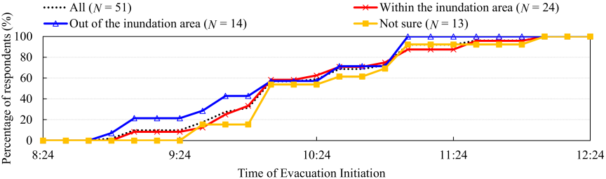
Fig. 4. Cumulative percentage of evacuation initiation times classified by perceived location (Q27) (\(N=51\)).
Figure 3 illustrates the primary triggers for evacuation initiation (Q26). The most frequently cited trigger was the “Announcement of Tsunami Warning” (52%). When this was combined with Tsunami Advisory and Evacuation Order, 81% of evacuees initiated evacuation based on official information. This trend is consistent with findings from the 2010 Chile earthquake tsunami, where a region-wide survey in Japan reported that municipal evacuation calls were the most frequently cited trigger 13. Differences due to location were not significant, suggesting that official information acts as the universal driver for action in far-field scenarios, replacing the role of natural cues (e.g., ground shaking) seen in near-field events.
Figure 4 shows the cumulative percentage of evacuation initiation times (Q27). More than half of the evacuees departed more than one hour after the earthquake. The timing varied widely, ranging from 08:45 to 12:00 (a span of over three hours). This temporal dispersion contrasts with the immediate, concentrated evacuation often observed in near-field tsunamis. It suggests that the lead time inherent in far-field tsunamis allows residents to deliberate on the necessity of evacuation and engage in preparatory actions (e.g., confirming information, securing property) before leaving. No significant difference in start times was observed based on location.
3.3. Evacuation Methods and Travel Time
Figure 5 presents evacuation methods (Q33). The most common mode of transport was by car. The primary reasons for choosing cars (Q34) were “Distance to the shelter” (29%), “Evacuating with family/others” (23%), and “Habitual use” (23%). The high reliance on cars aligns with previous findings. Imamura et al. 9 reported that during the 2022 Tonga volcanic tsunami, the suddenness of warning updates at night caused simultaneous mass evacuation, leading to severe traffic congestion. In the present study, however, only one respondent reported encountering traffic congestion in response to Q35. This result suggests that the phased issuance of warnings dispersed evacuation start times (Fig. 4), thereby effectively preventing traffic congestion. This suggests that the time margins in far-field scenarios, unlike those in sudden near-field events, can naturally mitigate traffic concentration.
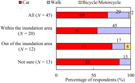
Fig. 5. Distribution of evacuation mode choice (Q33) (\(N=45\)).
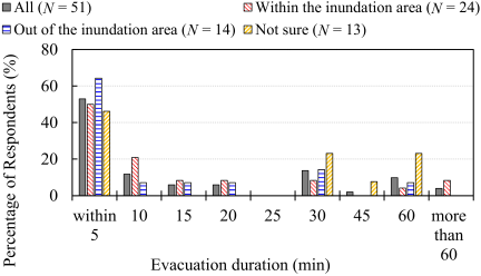
Fig. 6. Time elapsed between departure and arrival at a safe location (calculated from Q27 and Q28) (\(N=51\)).
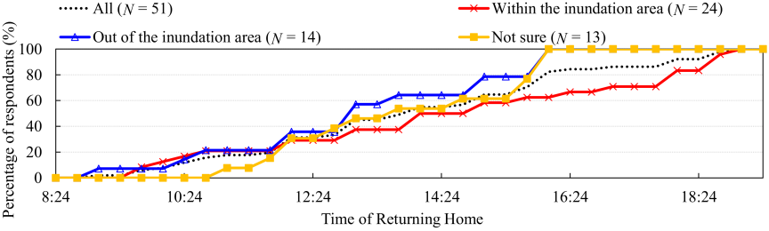
Fig. 7. Cumulative percentage of return times classified by perceived location (Q31) (\(N=51\)).
Figure 6 illustrates the duration required to reach a safe location after departure. While “Within 5 min” was the most common duration across all locations, a substantial portion of respondents took longer, with “Within 30 min” being the second most frequent category. This indicates that evacuation in far-field scenarios is often a prolonged process rather than an immediate flight. An analysis of specific actions taken during evacuation (Q30) reveals that residents utilized the available lead time to pick up family members or secure property, among other tasks. Notably, although not statistically significant, 8% of respondents inside the inundation zone took over 60 min to reach safety, reflecting the extended duration of these preparatory actions.
3.4. Timing and Triggers of Returning Home
Figure 7 shows the temporal distribution of when respondents ended their evacuation and returned home (Q31). While no statistically significant difference was observed based on location, residents inside the inundation zone tended to return later than those outside, suggesting a sustained wariness, which reflects their home’s higher risk level. The primary triggers for returning home (Q32) were predominantly subjective or social factors: “Thought the tsunami wouldn’t come anymore” (37%) and “People around me ended their evacuation” (13%). This starkly contrasts against near-field events; for instance, during the 2011 Tohoku earthquake tsunami, the most frequently cited reasons for returning were to inspect damage to homes or the physical recession of the inundation 2. Unlike in near-field events, where physical environmental cues are clear, far-field tsunamis lack obvious signs and often involve prolonged warning periods. This uncertainty renders the appropriate timing to end evacuation ambiguous, leading residents to rely more on subjective judgment and social conformity (i.e., following others) rather than waiting for official clearance.
3.5. Limitations
This study has several limitations. First, the use of a web-based survey may have introduced sampling bias, particularly the under-representation of elderly residents. Future studies should employ mixed-mode methods to ensure broader representation. Second, the analysis relied on self-reported data collected approximately three months after the event, introducing potential recall bias regarding precise times. Third, since recruitment was conducted through two distinct channels—random sampling and school-based distribution—a potential for overlapping invitations existed. To reduce the possibility of duplicate responses, the school-based invitation instructed recipients not to respond if they had already completed the survey through the municipal distribution. Although technical measures to prevent duplicate submissions were not implemented to prioritize respondent anonymity, a post-hoc review of demographic profiles and response patterns revealed no identical entries, suggesting that the overall statistical trends were not substantially affected. Fourth, residents’ location classification was based on the hazard map for the anticipated Nankai Trough earthquake (maximum 14 m tsunami), which differs in scale from the actual observed tsunami (0.5 m). Finally, due to the sample size of 283 being from a single municipality, the findings may not be fully generalizable to other regions.
4. Conclusions
This survey report examined residents’ evacuation behavior in Shingu City, Wakayama Prefecture, Japan, following the far-field tsunami generated by the 2025 Kamchatka Peninsula earthquake. The results indicate that perceived self-location relative to the estimated inundation zone played a critical role in evacuation decisions: residents perceiving themselves inside the zone had significantly higher evacuation rates (31%) compared to those outside the zone (11%) and the overall average (18%). In the absence of ground motion, official information, particularly the issuance of Tsunami Advisories, Warnings, and Evacuation Orders, served as the primary trigger for 81% of evacuees. Crucially, while spatial perception influenced the decision to evacuate, it did not dictate the specific evacuation process. Instead, the phased issuance of warnings likely contributed to the dispersion of evacuation start times, effectively preventing severe traffic congestion despite a high reliance on private vehicles. However, a significant challenge was identified in the “end-phase” of evacuation, where decisions to return home were largely driven by subjective judgment and social cues rather than official clearance.
These findings underscore the need for disaster management strategies tailored to far-field tsunamis. Regarding traffic management, the study observed that the phased issuance of warnings naturally dispersed evacuation timing. This suggests that, in far-field scenarios, the inherent time margins serve as a natural buffer against traffic congestion, unlike in sudden near-field events. Disaster planning should account for this distinct characteristic, recognizing that evacuation flow will likely be more gradual. Furthermore, regarding the “end-phase” of evacuation, the scientific difficulty in predicting the exact timing of tsunami energy decay should be recognized. Therefore, rather than solely relying on establishing rigid criteria for a safe return, risk communication should focus on counteracting residents’ “normalization bias.” Authorities should strongly emphasize that the absence of visible waves does not imply safety, thereby discouraging residents from making premature subjective decisions to return.
Appendix A. Supplementary Results of Questionnaire Responses by Perceived Location
Acknowledgments
The present study was supported by JST SPRING (Grant Number JPMJSP2182) and JSPS KAKENHI (Grant Numbers JP24K17488 and JP20KK0107). The authors also wish to thank Shingu City Hall and Kindai University Shingu Junior and Senior High School for their valuable cooperation in the distribution of the survey questionnaires. Finally, the authors are grateful to the residents of Shingu City for their participation in this study.
- [1] Japan Meteorological Agency, “Monthly report on earthquakes and volcanoes in Japan, July 2025,” 2025 (in Japanese). https://www.data.jma.go.jp/eqev/data/gaikyo/monthly/202507/202507monthly.pdf [Accessed December 16, 2025]
- [2] Cabinet Office of Japan, “Questionnaire survey on evacuation behavior of residents during the 2011 Great East Japan Earthquake (main results),” 2012 (in Japanese). https://www.bousai.go.jp/jishin/tsunami/hinan/pdf/20121221_chousa1_1.pdf [Accessed January 21, 2026]
- [3] M. K. Lindell et al., “Households’ immediate responses to the 2009 American Samoa earthquake and tsunami,” Int. J. Disaster Risk Reduct., Vol.12, pp. 328-340, 2015. https://doi.org/10.1016/j.ijdrr.2015.03.003
- [4] A. S. Harnantyari et al., “Tsunami awareness and evacuation behaviour during the 2018 Sulawesi earthquake tsunami,” Int. J. Disaster Risk Reduct., Vol.43, Article No.101389, 2020. https://doi.org/10.1016/j.ijdrr.2019.101389
- [5] N. Hasegawa et al., “Tsunami awareness, preparedness, and evacuation behaviors during the 2024 Noto Peninsula Earthquake tsunami,” Saf. Sci., Vol.189, Article No.106885, 2025. https://doi.org/10.1016/j.ssci.2025.106885
- [6] T. Takabatake and N. Hasegawa, “Tsunami evacuation behavior: A systematic review and proposal for a standardized research framework,” Nat. Hazards, Vol.122, Article No.280, 2026. https://doi.org/10.1007/s11069-026-08035-7
- [7] L. Dengler, S. Araya, N. Graehl, F. Luna, and T. Nicolini, “Factors that exacerbated or reduced impacts of the 27 February 2010 Chile tsunami,” Earthq. Spectra, Vol.28, No.1S1, pp. 199-213, 2012. https://doi.org/10.1193/1.4000033
- [8] T. Takabatake et al., “Field survey and evacuation behaviour during the 2018 Sunda Strait tsunami,” Coast. Eng. J., Vol.61, No.4, pp. 423-443, 2019. https://doi.org/10.1080/21664250.2019.1647963
- [9] F. Imamura et al., “Preliminary observations and impact in Japan of the tsunami caused by the Tonga volcanic eruption on January 15, 2022,” Pure Appl. Geophys., Vol.179, No.5, pp. 1549-1560, 2022. https://doi.org/10.1007/s00024-022-03058-0
- [10] A. Moore et al., “Coastal emergency managers’ risk perception and decision making for the Tonga distant tsunami,” Int. J. Disaster Risk Reduct., Vol.108, Article No.104560, 2024. https://doi.org/10.1016/j.ijdrr.2024.104560
- [11] California Coastal Commission, “The Tohoku tsunami of March 11, 2011: A preliminary report on effects to the California Coast and planning implications,” 2011. https://www.coastal.ca.gov/energy/tsunami/CCC_Tohoku_Tsunami_Report.pdf [Accessed February 5, 2026]
- [12] Shingu City, “Tsunami hazard map,” 2025 (in Japanese). https://www.city.shingu.lg.jp/div/bousai/pdf/hazard/32-33_hm_r7.pdf [Accessed December 16, 2025]
- [13] N. Hasegawa et al., “Analysis of tsunami response and evacuation behaviors in northern Hyogo: Insights from the 2024 Noto Peninsula earthquake tsunami,” Int. J. Disaster Risk Reduct., Vol.115, Article No.104993, 2024. https://doi.org/10.1016/j.ijdrr.2024.104993
- [14] Portal Site of Official Statistics of Japan (e-Stat), “Resident demographic data for each region,” 2020. https://www.e-stat.go.jp/en [Accessed December 16, 2025]
- [15] Cabinet Office of Japan, “Resident survey on tsunami associated with the earthquake near the Kamchatka Peninsula: Survey report,” Government of Japan, 2025 (in Japanese). https://www.e-stat.go.jp/statistics/00100307 [Accessed December 16, 2025]
This article is published under a Creative Commons Attribution-NoDerivatives 4.0 Internationa License.