Note:
Risk Governance and the Prevention of Sediment Disasters After the 2024 Mw 7.3 Hualien Earthquake in Eastern Taiwan —A Transdisciplinary Approach Case Study
Ting-Chi Tsao*,†, Jung-Hsing Chien*, Chen-Yu Chen**, and Hsiao-Yu Huang**
*Sinotech Engineering Consultants, Inc.
No.280 Xinhu 2nd Road, Neihu District, Taipei 114065, Taiwan
†Corresponding author
**Agency of Rural Development and Soil and Water Conservation, Ministry of Agriculture
Nantou, Taiwan

Following a major earthquake, the frequency of debris flows and landslides increases. To effectively mitigate the impact of these disasters and strengthen collaboration and information exchange among the central government, local authorities, and the public, adopting a transdisciplinary approach to disaster risk governance in earthquake-affected areas is crucial. On April 3, 2024, a magnitude 7.3 earthquake struck Hualien, triggering over 1,900 new landslides in eastern Taiwan. The resulting landslide debris poses a significant risk, potentially serving as a source for future debris flows. With the rainy season approaching in May, relevant government agencies responsible for debris flow disaster management have developed comprehensive strategies and actions for prevention, preparedness, response, and recovery phases to address these anticipated hazards.
An earthquake-triggered landslide
1. Introduction
Taiwan is situated in an active seismic zone of the western Pacific and experiences an average of three to four typhoons annually. Over three-quarters of the island’s area comprises steep slopes, where debris flows and landslides frequently occur during the typhoon season. According to the Disaster Prevention and Protection Act (2025), the Agency of Rural Development and Soil and Water Conservation (ARDSWC), Ministry of Agriculture, is responsible for the prevention, response, and post-disaster reconstruction of large-scale landslides and debris flows. It also conducts surveys and analyses of disaster potential, hazard levels, scenario simulations, and risk assessments for these disasters and publishes the results in a timely manner. Over the past two decades, the central and local governments in Taiwan have established comprehensive assessments, early warnings, and evacuation mechanisms that have effectively reduced casualties and losses from sediment disasters 1,2.
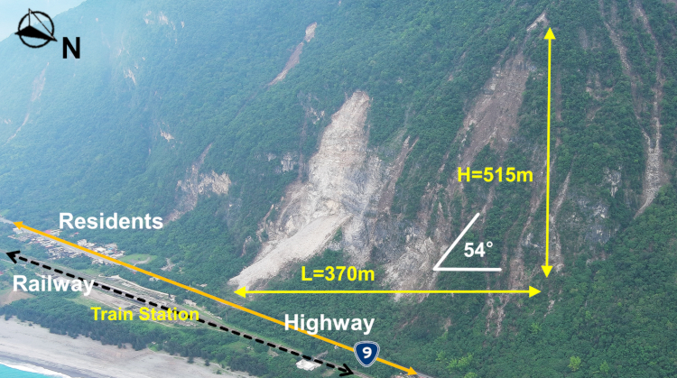
Fig. 1. An earthquake-triggered landslide close to railway, highway, and residential houses.
On the morning of April 3, 2024, an earthquake of magnitude 7.3 struck Hualien in eastern Taiwan 3,4. In addition to the damage and collapse of several buildings in urban areas, public infrastructure, including railways, highways, bridges, and water supply facilities, was also damaged 5. Notably, over 1,900 new landslides were triggered in the mountainous areas of Hualien, damaging the transportation corridor 6 (Fig. 1).
Following a major earthquake, the probability of secondary sediment disasters such as landslides and debris flows increases significantly 7,8,9. For example, following the 1999 Chi-Chi earthquake in Taiwan, the 2001 typhoon event caused extensive sediment disasters in the earthquake-affected area, resulting in significant casualties 10,11. Similarly, after the 2008 Wenchuan earthquake in China, major landslides and debris flows occurred in the earthquake-affected mountainous regions during subsequent rainy seasons 12,13. Research indicates that the impact of strong earthquakes on sediment disaster frequency can persist for several years to decades 14,15, often with an increased scale and scope, posing significant challenges to post-earthquake debris flow risk management.
However, the rainy season (flood season) in Taiwan begins in May 16, and typhoons that strike often bring hundreds of millimeters of accumulated rainfall 17,18. Such rainfall can cause severe landslides in earthquake-affected areas, limiting the time available for preparatory work.
Taiwan has made notable progress in debris flow prevention over the past 20 years 19. However, following major earthquakes, the scale of sediment disasters is often greater than that experienced previously, and the scope and severity of the impact exceed prior experience. Local governments and residents frequently lack the experience necessary to effectively prevent landslides and debris flows based on past practices. In restoration assessments, landslides not only affect local residents but can also cause damage and disruption to regional railways and highways. The response to disasters of this magnitude has been unprecedented in Taiwan. Therefore, close collaboration among residents, local governments, slope land management agencies, and transportation authorities is essential for mitigating potential disaster risks and achieving effective risk governance.
2. Transdisciplinary Approach in Disaster Risk Governance
Given the limited time for pre-disaster preparation, the extensive scope of impact, and the anticipation of a large-scale disaster, disaster preparedness responsibilities span multiple agencies and central and local governments. However, stakeholders lack the professional knowledge and judgment to assess the affected areas, the scale, and the evacuation timing. Therefore, professional expertise, data transparency, and transdisciplinary communication should be used to inform local governments, the public, transportation management authorities, and others about potential disaster locations and scales following an earthquake. This can enhance the effectiveness of post-earthquake sediment disaster preparedness. It involves vertical and horizontal communication across fields, such as civil engineering, soil and water conservation, geology, remote sensing, disaster prevention, public administration, transportation, and civil defense. Traditional analysis and communication models would likely prove inefficient; therefore, a transdisciplinary approach to risk governance is essential 20,21.
In recent years, there has been growing international consensus on the use of transdisciplinary approaches to address disaster 22,23,24. Several studies have employed transdisciplinary frameworks to analyze natural disasters such as floods, earthquakes, landslides, and the COVID-19 pandemic 25,26,27,28. Transdisciplinary approaches can be used to resolve disaster management issues involving multiple stakeholders and departments based on scientific evidence and by integrating the public, private, and community sectors 29,30.
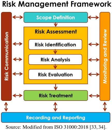
Fig. 2. A typical risk management framework.
The ARDSWC of Taiwan, which is responsible for managing large-scale landslides and debris flow disasters, has formulated pre-disaster preparedness measures to be completed from the post-earthquake period to the pre-rainy season based on the principles of disaster risk management. These measures comprise risk identification, risk assessment, risk communication, and risk governance. The ARDSWC shares and promotes disaster prevention information with other government agencies and local governments and residents in the earthquake-affected areas. This inter-agency, interdisciplinary, and cross-stakeholder approach to natural disaster risk governance exemplifies a typical transdisciplinary process 31,32.
3. Risk Governance of Sediment Disaster in Earthquake-Struck Area
According to the natural disaster risk management framework, the risk management and governance of sediment disasters include key aspects such as risk identification, risk analysis, risk evaluation, risk treatment, and risk communication (Fig. 2) 33,34. Fig. 2 provides an example of the ARDSWC’s post-2024 Hualien earthquake disaster prevention preparations in Taiwan, focusing on these aspects.
3.1. Risk Identification
Risk identification involves identifying the sources of risks, hazard factors, perils, and exposure 35. It is the first stage of risk management. Following the Hualien earthquake, the risk identification measures adopted by the authorities included the following.
3.1.1. Satellite Interpretation
By comparing the optical satellite imagery before and after the earthquake, newly induced landslides were identified as hotspots for assessing the potential for further landslides or debris flows. As of the end of May 2024, 1,942 new landslides were identified in the earthquake-affected area, covering an area of 1,521 hectares, primarily concentrated in areas with a seismic intensity of six or greater. Among them, 57 landslides occurred near railways or major highways. The aforementioned interpretation results have been made publicly available online in GIS layers for download and use by government agencies and the public and have been formally notified to local governments and railway and highway management authorities.
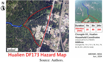
Fig. 3. The hazard map of Hualien DF173 potential debris flow torrent.
3.1.2. Field Investigation
For the 1,942 newly formed landslides, an initial assessment of the potential impact on protected households was conducted indoors using superposition techniques. If it was determined that protected households were at risk of being affected by landslides or debris flows, experts and scholars convened to conduct a field investigation. Based on scientific data and academic principles, the type of damage and extent of the impact were confirmed, and new potential debris flow torrents or newly designated landslide-sensitive areas were incorporated. Following the field investigations, four torrents were urgently added as potential debris flow torrents and eight as post-earthquake landslide-sensitive areas in early June. An additional 26 torrents, already designated as potential debris-flow torrents, were also reviewed on-site. Hazard maps were prepared and updated by local governments and made available to the public for each location (Fig. 3).
3.1.3. Evacuation List Establishment
For newly added and adjusted debris flow potential torrent risk maps located in earthquake-affected areas, a list of protected households based on the scientific results of on-site surveys needed to be established. This list must include the number of current residents and the contact information for each household to facilitate the evacuation of residents when alerts are issued.
3.2. Risk Analysis
Risk analysis involves developing an understanding of each risk, its consequences, and the likelihood of each of those consequences 33. Some of the risk analysis measures conducted after the Hualien earthquake are as follows.
3.2.1. Warning Threshold Setting
Triggering rainfall thresholds for debris flows following major earthquakes will be significantly reduced. Therefore, rainfall thresholds for areas with a seismic intensity of five or higher were adjusted based on scientific principles. A total of 92 rainfall thresholds in earthquake-affected areas were reduced by 50 mm to 150 mm, and the issuance mechanisms for red and yellow alerts for debris flows were adjusted accordingly.
In areas with post-earthquake sediment hazards, a much lower rainfall threshold can easily trigger secondary disasters due to the instability of debris. Therefore, in regions where rainfall alerts have already been lowered, if there is a large amount of unstable debris, an additional rainfall alert value will be set. Local residents will be notified in advance to prepare for disaster prevention through means such as SMS broadcast and Line notifications.
3.3. Risk Communication
Risk communication helps stakeholders understand disaster risks associated with natural hazards 36 and plays a vital role in conveying information before, during, and after a disaster 37. The risk communication measures applied after the Hualien earthquake included the following.
3.3.1. Media Publicity
Communicating the distribution of earthquake-induced landslides and scientific analysis results regarding anticipated larger-than-usual debris flows during future typhoons to the public through television, newspapers, radio, electronic media, and social media platforms played a crucial role. In addition, calls on the public to cooperate with evacuation and shelter during typhoons also played an important role.
3.3.2. Visit Local Governments
Representatives of the ARDSWC visited county governments, township offices, and village heads to brief local leaders and residents on post-earthquake disaster prevention measures, preparations during the flood season, and new disaster prevention information and initiatives in response to the Hualien earthquake. They also requested that the local governments update their evacuation plans. These visits facilitated the communication of scientific data and professional assessments to frontline disaster relief personnel, providing the necessary explanations and assistance to help the central and local authorities collaborate on risk governance. By the end of April 2024, six township offices were visited, and by early June, all 12 county governments, township offices, and village heads had been visited (Fig. 4).
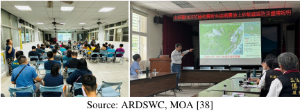
Fig. 4. Agency personnel visit village office (left) and township government (right) explaining landslide and debris flow risks after the Hualien earthquake.
3.3.3. LINE Group Establishment
To improve communication among various agencies, a LINE group for the earthquake-stricken region was established. It included the Hualien County Magistrate, various bureaus and departments of the county government, township offices, central agencies stationed in the county, and utility service units. The group utilized instant messaging apps to rapidly share pre-disaster, disaster, and post-disaster information and updates.
3.3.4. Joint On-Site Survey
Anticipating the formation of debris flows in new landslide areas during the typhoon season, monthly joint defense and remediation meetings were held. Restoration assessments were discussed with the railway and highway management units, rural townships, and the Ministry of Transportation. This collaborative approach facilitated communication and cooperation between agencies to mitigate landslides and debris flow disasters in earthquake-affected areas and improve post-earthquake risk governance.
3.3.5. Monthly Governance Meeting
Through monthly meetings with official agencies, the latest information on landslides and debris flow disasters in earthquake-affected areas was shared, and risk governance for post-earthquake debris flows was conducted based on scientific data and public information.
3.4. Risk Treatment
The purpose of risk treatment is to reduce the likelihood of harm to stakeholders by selecting and implementing appropriate mitigation options 39. The risk treatment measures introduced after the Hualien earthquake are as follows.
3.4.1. On-Site Investigation by Experts and Scholars
Government agencies, experts, and scholars jointly inspected and discussed engineering solutions for debris flow disasters and developed site-specific engineering plans based on academic and scientific evidence.
3.4.2. Emergency Engineering Treatment
For watersheds with significant colluvial debris accumulation, emergency temporary drainage and sediment control measures were implemented to mitigate the impact of soil and sediment disasters before the completion of long-term engineering works.
3.4.3. Restoration and Dredging
Following a landslide or debris flow, emergency restoration work was carried out within the jurisdictions of each level of government agency in accordance with their respective responsibilities.
3.4.4. Reconstruction
Long-term reconstruction projects were carried out within the areas of responsibility of respective government agencies at all levels.
3.4.5. CCD Monitoring
CCD surveillance cameras were installed in high-risk debris-flow-prone areas to monitor torrent conditions in real time and facilitate emergency response and evacuation.
3.4.6. Typhoon and Heavy Rainfall Evacuation
Based on the areas affected by debris flows, as defined by preparedness levels and rainfall alert thresholds, in conjunction with the list of protected households established by local governments, evacuation of the protected households to designated shelters was undertaken after a red or yellow alert was issued in accordance with the evacuation plan.
4. Sediment Disasters During Typhoon Gaemi
The first typhoon to impact Taiwan following the 2024 Hualien earthquake was Typhoon Gaemi, which affected Taiwan between July 23 and July 26, 2024. During the 96-hour period, the maximum accumulated rainfall across Taiwan was 1,933.5 mm in Kaohsiung (southwest Taiwan). Approximately 550 mm of accumulated rainfall also affected the earthquake-affected area in northern Hualien, leading to severe landslides and debris flows along the Suhua Highway and North-Link Railway Corridor 40.
The only northbound road of the Hualien region, Provincial Highway No.9 (the Suhua Highway), experienced five severe landslides within a mere five-kilometer stretch, and was not fully reopened until July 30. The North-Link Railway in the same corridor was also damaged, experiencing three debris flows submerging the railway tracks within approximately 5 km, along with a 21,500 m\(^{3}\) debris flow that destroyed a railway bridge, causing a 10-day shutdown of the railway (Fig. 5) 41,42.

Fig. 5. Debris flow destroyed the North-Link Railway and Suhua Highway (Route No.9) during Typhoon Gaemi.
Table 1. Debris flow disaster records of the three newly added potential debris flow torrents during Typhoon Gaemi, 2024.

Post-event statistics revealed that of the four potential debris flow torrents that were urgently added in early June, three experienced debris flows during Typhoon Gaemi (Table 1). Fortunately, owing to timely evacuations, no casualties occurred. Considering the Hualien County DF173 debris flow as an example, a typhoon land warning was issued on July 23, with a yellow alert at 6:30 PM, and a red alert at 6:30 PM on July 24. The township office, village head, police, and military conducted evacuation procedures at 3:00 PM on July 24. A debris flow occurred at 7:00 AM on July 25 when the accumulated rainfall reached 403.7 mm. However, no casualties were reported owing to the pre-emptive evacuation of residents. Following the lifting of the typhoon alert, contractors from the township office moved immediately to clear the debris and prevent further escalation of the disaster.
During Typhoon Gaemi, the ARDSWC issued 28 red alerts, 77 yellow alerts, and 54 cellular broadcast messages regarding debris flows in the Hualien earthquake-affected area. Local governments, based on alerts from central authorities, evacuated a total of 1,783 individuals. No fatalities or injuries were recorded in the Hualien area during this typhoon period.
5. Conclusions
Eastern Taiwan experienced nearly 2,000 landslides following the 2024 Hualien earthquake. Slopeland areas became highly unstable after being disturbed by a strong earthquake, and significantly larger-scale debris flows were anticipated during subsequent typhoon seasons. Risk governance for post-earthquake debris flows cannot be addressed solely by individual government agencies or local governments. It requires collaboration between agencies and central and local authorities, together with cooperation between the government and the public to confront the threat of compound disasters following an earthquake.
This study analyzes the implementation of scientific evidence and risk management through transdisciplinary risk governance following the 2024 Hualien earthquake, ensuring that these elements reach all stakeholders affected by post-earthquake debris flow disasters. Starting with the interpretation of landslides and extending to on-site risk mitigation engineering measures, all processes were conducted with a focus on sharing disaster-prevention information and ensuring transparent and open decision-making. This enabled effective collaboration among the public and private sectors and residents, allowing communities to withstand the typhoon in July following the earthquake, thereby minimizing casualties and demonstrating a practical application of transdisciplinary disaster risk governance.
However, Taiwan is situated in an environment prone to frequent earthquakes and typhoons, and the challenges posed by future extreme climate conditions are severe. Natural disasters that exceed past experiences will inevitably increase in number. Adopting a transdisciplinary approach to natural disaster risk management and governance represents a viable direction for future projects.
Acknowledgments
The authors would like to thank the Agency of Rural Development and Soil and Water Conservation (ARDSWC), Ministry of Agriculture, Taiwan, for providing source materials for this study.
- [1] S.-C. Chen and C.-Y. Wu, “Debris flow disaster prevention and mitigation of non-structural strategies in Taiwan,” J. Mt. Sci., Vol.11, No.2, pp. 308-322, 2014. https://doi.org/10.1007/s11629-014-2987-3
- [2] L.-C. Chen, J.-Y. Wu, and M.-J. Lai, “The evolution of the natural disaster management system in Taiwan,” J. Chin. Inst. Eng., Vol.29, No.4, pp. 633-638, 2006. https://doi.org/10.1080/02533839.2006.9671159
- [3] Y.-H. Lin and Y.-M. Wu, “Magnitude determination for earthquake early warning using P P-alert low-cost sensors during 2024 Mw7.4 Hualien, Taiwan earthquake,” Sci. Rep., Vol.15, Article No.12538, 2025. https://doi.org/10.1038/s41598-025-97748-z
- [4] W. Peng, K. H. Chen, R. Bürgmann, Y.-J. Hsu, and Y.-H. Chen, “Aseismic slip and seismic swarms leading up to the 2024 M7.3 Hualien earthquake,” Nat. Commun., Vol.16, Article No.9066, 2025. https://doi.org/10.1038/s41467-025-64117-3
- [5] R. Enokida et al., “Earthquake disaster resilience in Taiwan observed from the April 2024 mathrm{M}_{mathrm{L}} ML 7.1 Hualien earthquake,” Front. Built Environ., Vol.11, Article No.1593942, 2025. https://doi.org/10.3389/fbuil.2025.1593942
- [6] J.-M. Chang, W.-A. Chao, C.-M. Yang, and M.-W. Huang, “Coseismic and subsequent landslides of the 2024 Hualien earthquake (M7.2) on April 3 in Taiwan,” Landslides, Vol.21, No.10, pp. 2591-2595, 2024. https://doi.org/10.1007/s10346-024-02312-x
- [7] M. Chen, C. Tang, J. Xiong, M. Chang, and N. Li, “Spatio-temporal mapping and long-term evolution of debris flow activity after a high magnitude earthquake,” CATENA, Vol.236, Article No.107716, 2024. https://doi.org/10.1016/j.catena.2023.107716
- [8] T. Görüm et al., “The 2023 Türkiye-Syria earthquake disaster was exacerbated by an atmospheric river,” Commun. Earth Environ., Vol.6, Article No.151, 2025. https://doi.org/10.1038/s43247-025-02111-9
- [9] X. Fan et al., “Earthquake-induced chains of geologic hazards: Patterns, mechanisms, and impacts,” Rev. Geophys., Vol.57, No.2, pp. 421-503, 2019. https://doi.org/10.1029/2018RG000626
- [10] C.-W. Lin et al., “Impact of Chi-Chi earthquake on the occurrence of landslides and debris flows: Example from the Chenyulan River watershed, Nantou, Taiwan,” Eng. Geol., Vol.71, Nos.1-2, pp. 49-61, 2004. https://doi.org/10.1016/S0013-7952(03)00125-X
- [11] J. C. Chen, C. D. Jan, and W. S. Huang, “Characteristics of rainfall triggering of debris flows in the Chenyulan watershed, Taiwan,” Nat. Hazards Earth Syst. Sci., Vol.13, No.4, pp. 1015-1023, 2013. https://doi.org/10.5194/nhess-13-1015-2013
- [12] C. Tang, J. Zhu, W. L. Li, and J. T. Liang, “Rainfall-triggered debris flows following the Wenchuan earthquake,” Bull. Eng. Geol. Environ., Vol.68, No.2, pp. 187-194, 2009. https://doi.org/10.1007/s10064-009-0201-6
- [13] C. Li, M. Wang, and K. Liu, “A decadal evolution of landslides and debris flows after the Wenchuan earthquake,” Geomorphology, Vol.323, pp. 1-12, 2018. https://doi.org/10.1016/j.geomorph.2018.09.010
- [14] H. Tanyaş et al., “A closer look at factors governing landslide recovery time in post-seismic periods,” Geomorphology, Vol.391, Article No.107912, 2021. https://doi.org/10.1016/j.geomorph.2021.107912
- [15] L. Dai et al., “Coseismic debris remains in the orogen despite a decade of enhanced landsliding,” Geophys. Res. Lett., Vol.48, No.19, Article No.e2021GL095850, 2021. https://doi.org/10.1029/2021GL095850
- [16] Y.-H. Hsiao et al., “Analysis of the impact of flood disasters on aquaculture in a warming scenario – With aquaculture in Pingtung County as an example,” J. Water Clim. Change, Vol.16, No.11, pp. 3416-3427, 2025. https://doi.org/10.2166/wcc.2025.110
- [17] S.-H. Su, H.-C. Kuo, L.-H. Hsu, and Y.-T. Yang, “Temporal and spatial characteristics of typhoon extreme rainfall in Taiwan,” J. Meteorol. Soc. Jpn. II, Vol.90, No.5, pp. 721-736, 2012. https://doi.org/10.2151/jmsj.2012-510
- [18] Y.-H. Chen, H.-C. Kuo, C.-C. Wang, and Y.-T. Yang, “Influence of southwest monsoon flow and typhoon track on Taiwan rainfall during the exit phase: Modelling study of typhoon Morakot (2009),” Q. J. R. Meteorol. Soc., Vol.143, No.709, pp. 3014-3024, 2017. https://doi.org/10.1002/qj.3156
- [19] T.-C. Tsao and C.-Y. Chen, “Transdisciplinary approach toward preparedness in a mountainous community in central Taiwan and its impact on disaster evacuation: A case study,” J. Disaster Res., Vol.18, No.5, pp. 456-461, 2023. https://doi.org/10.20965/jdr.2023.p0456
- [20] E. Alam and N. S. Ray-Bennett, “Disaster risk governance for district-level landslide risk management in Bangladesh,” Int. J. Disaster Risk Reduct., Vol.59, Article No.102220, 2021. https://doi.org/10.1016/j.ijdrr.2021.102220
- [21] V. Capobianco et al., “Effective landslide risk management in era of climate change, demographic change, and evolving societal priorities,” Landslides, Vol.22, No.9, pp. 2915-2933, 2025. https://doi.org/10.1007/s10346-024-02418-2
- [22] V. Braun et al., “Tackling inter- and transdisciplinary challenges: A new research approach for the Institute for Interdisciplinary Mountain Research,” Mt. Res. Dev., Vol.44, No.4, pp. P1-P2, 2024. https://doi.org/10.1659/mrd.2024.00029
- [23] S. Lenzi, J. Sádaba, and A. Retegi, “Climate adaptation in urban space: The need for a transdisciplinary approach,” Front. Sustain. Cities, Vol.7, Article No.1562066, 2025. https://doi.org/10.3389/frsc.2025.1562066
- [24] S. Pedde et al., “Leveraging climate resilience capacities by (un)learning from transdisciplinary research projects,” Clim. Risk Manag., Vol.47, Article No.100675, 2025. https://doi.org/10.1016/j.crm.2024.100675
- [25] K. Tsukahara, “The transdisciplinary approach to developing an integrated water-related disaster information system for municipalities,” J. Disaster Res., Vol.18, No.5, pp. 462-466, 2023. https://doi.org/10.20965/jdr.2023.p0462
- [26] I. Alcántara-Ayala, “Landslides in a changing world,” Landslides, Vol.22, No.9, pp. 2851-2865, 2025. https://doi.org/10.1007/s10346-024-02451-1
- [27] I. Dallo et al., “The need for open, transdisciplinary, and ethical science in seismology,” Seismica, Vol.2, No.2, 2023. https://doi.org/10.26443/seismica.v2i2.470
- [28] M. Inoue et al., “Building disaster resilience amid the COVID-19 pandemic: A transdisciplinary approach for decision making,” J. Disaster Res., Vol.17, No.1, pp. 144-151, 2022. https://doi.org/10.20965/jdr.2022.p0144
- [29] K. Takeuchi et al., “Challenges of transdisciplinary approach in disaster recovery management,” Nat. Hazards, Vol.120, No.13, pp. 12471-12489, 2024. https://doi.org/10.1007/s11069-024-06693-z
- [30] M. Ishiwatari et al., “Transdisciplinary approach: Toward innovative recovery and disaster risk reduction,” J. Disaster Res., Vol.19, No.3, pp. 534-538, 2024. https://doi.org/10.20965/jdr.2024.p0534
- [31] M. Micu and I. Roznovietchi, “Building landslide risk culture in Romania: The role of geomorphology within a transdisciplinary approach,” Landslides, Vol.22, No.9, pp. 3133-3147, 2025. https://doi.org/10.1007/s10346-025-02529-4
- [32] J. Parviainen et al., “The Risk-Tandem Framework: An iterative framework for combining risk governance and knowledge co-production toward integrated disaster risk management and climate change adaptation,” Int. J. Disaster Risk Reduct., Vol.116, Article No.105070, 2025. https://doi.org/10.1016/j.ijdrr.2024.105070
- [33] International Organization for Standardization (ISO), “ISO 31000:2018: Risk management—Guidelines,” 2018.
- [34] W.-C. Lo, T.-C. Tsao, and C.-H. Hsu, “Building vulnerability to debris flows in Taiwan: A preliminary study,” Nat. Hazards, Vol.64, No.3, pp. 2107-2128, 2012. https://doi.org/10.1007/s11069-012-0124-6
- [35] L. Tchankova, “Risk identification – Basic stage in risk management,” Environ. Manag. Health, Vol.13, No.3, pp. 290-297, 2002. https://doi.org/10.1108/09566160210431088
- [36] I. Alcántara-Ayala and A. R. Moreno, “Landslide risk perception and communication for disaster risk management in mountain areas of developing countries: A Mexican foretaste,” J. Mt. Sci., Vol.13, No.12, pp. 2079-2093, 2016. https://doi.org/10.1007/s11629-015-3823-0
- [37] C. Bhandari, A. Scolobig, J. Abderhalden, P. Weyrich, and M. Stoffel, “Risk communication policies and strategies in Nepal and Switzerland: A comparative study,” Int. J. Disaster Risk Reduct., Vol.129, Article No.105773, 2025. https://doi.org/10.1016/j.ijdrr.2025.105773
- [38] Agency of Rural Development and Soil and Water Conservation, MOA (in Chinese). https://246.ardswc.gov.tw/DisasterApplication/ImportantEvent [Accessed November 1, 2025].
- [39] K. Durham, “Treating the risks in Cairns,” Nat. Hazards, Vol.30, No.2, pp. 251-261, 2003. https://doi.org/10.1023/A:1026174602731
- [40] National Science and Technology Center for Disaster Reduction (NCDR), “Summary report on the disaster of 2024 Typhoon Gaemi,” 2024 (in Chinese).
- [41] Eastern Region Branch Office, Highway Bureau, MOTC (in Chinese). https://thbu4.thb.gov.tw/ [Accessed November 1, 2025]
- [42] C.-H. Li, “Typhoon Gaemi damages the Taiwan Railway’s Hualien-Taitung Line, with the Xiaoqingshui Creek Bridge washed away,” EBC News Channel, July 25, 2024. https://news.ebc.net.tw/news/living/433433 [Accessed November 1, 2025]
This article is published under a Creative Commons Attribution-NoDerivatives 4.0 Internationa License.