Research Paper:
Integration of Three-Dimensional Point Clouds and Sensing Data for Digital Twin-Oriented Construction Management
Satoshi Kubota*,†, Aika Yamaguchi**, Tomoharu Tanaka*, Kazana Harada*, Tsubasa Hayakawa*, and Kazuki Nakata*
*Faculty of Environmental and Urban Engineering, Kansai University
3-3-35 Yamatecho, Suita, Osaka 564-8680, Japan
†Corresponding author
**Graduate School of Science and Engineering, Kansai University
Suita, Japan

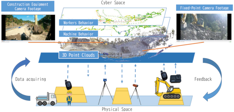
Construction sites vary widely in scale and conditions, making it difficult to adopt a unified method for acquiring three-dimensional (3D) data. Standardized procedures for transferring 3D data across project phases and practical methods for utilizing such data have not yet been established. This study proposes a construction information system based on point-cloud data to support the development of a construction site digital twin. Field experiments were conducted at small-, medium-, and large-scale construction sites to evaluate the system’s applicability across progress, quality, and safety management. For progress management, daily point-cloud data acquired by unmanned aerial vehicles and high-elevation cameras were superimposed to visualize construction progress, and quantitative assessment of earthwork changes was achieved through point-to-point distance analysis. For quality management, time-synchronized video data enabled reconstruction of past site conditions from multiple viewpoints. For safety management, a single worker’s position data and heart rate data were actually collected and visualized, and a conceptual use case for integrating biometric information with point-cloud data was presented. At large-scale construction sites, unified management was demonstrated by integrating point-cloud data from multiple work areas on a single data platform using coordinate assignment and time-axis management. In this study, work areas refer to spatial subdivisions used for construction management purposes, rather than contractual or organizational boundaries. The results indicate that the proposed system can support efficient progress sharing and enhance situational awareness among stakeholders.
Visualization of construction site digital twin
- [1] H-C. Nguyen and B-R. Lee, “3D model reconstruction system development based on laser-vision technology,” Int. J. Automation Technol., Vol.10, No.5, pp. 813-820, 2016. https://doi.org/10.20965/ijat.2016.p0813
- [2] J. Su, R. Miyazaki, T. Tamaki, and K. Kaneda, “3D modeling of lane marks using a combination of images and mobile mapping data,” Int. J. Automation Technol., Vol.12, No.3, pp. 386-394, 2018. https://doi.org/10.20965/ijat.2018.p0386
- [3] F. Tanaka, M. Tsuchida, and M. Onosato, “Associating 2D sketch information with 3D CAD models for VR/AR viewing during bridge maintenance process,” Int. J. Automation Technol., Vol.13, No.4, pp. 482-489, 2019. https://doi.org/10.20965/ijat.2019.p0482
- [4] N. Kochi, S. Isobe, A. Hayashi, K. Kodama, and T. Tanabata, “Introduction of all-around 3D modeling methods for investigation of plants,” Int. J. Automation Technol., Vol.15, No.3, pp. 301-312, 2021. https://doi.org/10.20965/ijat.2021.p0301
- [5] K. Otani, T. Nagumo, and H. Masuda, “Data augmentation for deep learning training with virtual point clouds generated from CAD models,” Int. J. Automation Technol., Vol.19, No.6, pp. 1048-1057, 2025. https://doi.org/10.20965/ijat.2025.p1048
- [6] H. Date et al., “Efficient registration of laser-scanned point clouds of bridges using linear features,” Int. J. Automation Technol., Vol.12, No.3, pp. 328-338, 2018. https://doi.org/10.20965/ijat.2018.p0328
- [7] T. T. Ho et al., “Robustness of structure from motion accuracy/precision against the non-optimality in analysis settings: Case study in constant-pitch flight design,” Int. J. Automation Technol., Vol.18, No.5, pp. 621-631, 2024. https://doi.org/10.20965/ijat.2024.p0621
- [8] A. Yamaguchi, K. Harada, and S. Kubota, “Visualization of construction progress and information system concept using three-dimensional point cloud data,” Artificial Intelligence and Data Science, Vol.3, No.J2, pp. 277-286, 2022 (in Japanese). https://doi.org/10.11532/jsceiii.3.J2_277
- [9] A. Yamaguchi, T. Tanaka, and S. Kubota, “Digital twin of construction site based on three-dimensional point cloud data,” Japanese J. of JSCE, Vol.79, No.22, Article No.22-22044, 2023 (in Japanese). https://doi.org/10.2208/jscejj.22-22044
- [10] S. Kubota, T. Hayakawa, A. Yamaguchi, and Y. Yasumuro, “Visualization and centralized management of progress using 3D data at large-scale construction sites,” Artificial Intelligence and Data Science, Vol.4, No.3, pp. 786-793, 2023 (in Japanese). https://doi.org/10.11532/jsceiii.4.3_786
- [11] S. Kubota and A. Yamaguchi, “Development of a construction-information system by measuring, processing, and utilizing 3D data toward creating a digital twin,” Proc. of the 42nd Int. Symp. on Automation and Robotics in Construction, pp. 665-673, 2025. https://doi.org/10.22260/ISARC2025/0087
- [12] C. Ye et al., “A digital twin of bridges for structural health monitoring,” Proc. of the 12th Int. Workshop on Structural Health Monitoring, 2019. https://doi.org/10.12783/shm2019/32287
- [13] J. Fujii, R. Yoshida, and M. Amakata, “Proposal for DX in urban river management using digital twin,” Artificial Intelligence and Data Science, Vol.2, No.J2, pp. 495-502, 2021 (in Japanese). https://doi.org/10.11532/jsceiii.2.J2_495
- [14] buildingSMART International. https://www.buildingsmart.org [Accessed December 26, 2025]
- [15] buildingSMART International, “Industry Foundation Classes (IFC).” https://www.buildingsmart.org/standards/bsi-standards/industry-foundation-classes/ [Accessed December 26, 2025]
- [16] T. Suzuki, S. Shiozawa, A. Yamaba, and Y. Amano, “Forest data collection by UAV lidar-based 3D mapping: Segmentation of individual tree information from 3D point clouds,” Int. J. Automation Technol., Vol.15, No.3, pp. 313-323, 2021. https://doi.org/10.20965/ijat.2021.p0313
- [17] S. Nishiwaki, H. Kondo, S. Yoshida, and T. Emaru, “Proposal of UAV-SLAM-based 3D point cloud map generation method for orchards measurements,” J. Robot. Mechatron., Vol.36, No.5, pp. 1001-1009, 2024. https://doi.org/10.20965/jrm.2024.p1001
- [18] K. Ohno, H. Date, and S. Kanai, “Study on real-time point cloud superimposition on camera image to assist environmental three-dimensional laser scanning,” Int. J. Automation Technol., Vol.15, No.3, pp. 324-333, 2021. https://doi.org/10.20965/ijat.2021.p0324
- [19] H. C. Yuan and S. Kubota, “Updating and utilizing 3D point cloud data of road structures using multiple measurement devices,” Proc. of the 20th Int. Conf. on Computing in Civil and Building Engineering, Vol.1, pp. 662-673, 2025. https://doi.org/10.1007/978-3-031-84208-5_49
- [20] M. Soilán, D. González-Aguilera, A. del-Campo-Sánchez, D. Hernández-López, and S. Del Pozo, “Roar marking degradation analysis using 3D point cloud data acquired with a low-cost Mobile Mapping System,” Automation in Construction, Vol.141, Article No.104446, 2022. https://doi.org/10.1016/j.autcon.2022.104446
- [21] H. J. Wang, J. P. Zhang, K. W. Chau, and M. Anson, “4D dynamic management for construction planning and resource utilization,” Automation in Construction, Vol.13, No.5, pp. 575-589, 2004. https://doi.org/10.1016/j.autcon.2004.04.003
- [22] Z. Ma, Q. Shen, and J. Zhang, “Application of 4D for dynamic site layout and management of construction projects,” Automation in Construction, Vol.14, No.3, pp. 369-381, 2005. https://doi.org/10.1016/j.autcon.2004.08.011
- [23] K. Kanzaki, “Utilization of the three-dimensional model to a construction production system,” J. of Japan Society of Civil Engineers, Ser. F4 (Construction and Management), Vol.73, No.4, pp. I_55-I_63, 2017 (in Japanese). https://doi.org/10.2208/jscejcm.73.I_55
- [24] K. Nakamura, Y. Umehara, M. Nakahara, and R. Imai, “4D spatial–temporal information infrastructure for digital twin environments using spatial IDs,” Computer-Aided Civil and Infrastructure Engineering, Vol.40, No.30, pp. 6184-6200, 2025. https://doi.org/10.1111/mice.70146
- [25] G. Garcés, “Advances in human-robot collaboration (HRC) in Construction 5.0 for building construction: A bibliometric and systematic literature review,” J. of Information Technology in Construction, Vol.30, pp. 1244-1276, 2025. https://doi.org/10.36680/j.itcon.2025.050
- [26] European Telecommunications Standards Institute, “Intelligent transport systems (ITS); Vehicular communications; Basic set of applications; Local dynamic map (LDM); Rationale for and guidance on standardization (ETSI TR 102 863 V1.1.1),” 2011.
- [27] Special Interest Group on Information Systems, Information Processing Society of Japan, “Information systems,” Digital dictionary—Basic knowledge of important terms (2nd edition), 2019. https://ipsj-is.jp/isdic/1095 [Accessed December 26, 2025]
This article is published under a Creative Commons Attribution-NoDerivatives 4.0 Internationa License.