
Paper:
Development of Compact Autonomous Roadside Weeding Robot for Road Infrastructure Maintenance
Yuki Matsushita*,†, Yuya Hosoda**
 , Ryuji Okada*, and Joo-Ho Lee**
*Graduate School of Information Science and Engineering, Ritsumeikan University
2-150 Iwakura-cho, Ibaraki, Osaka 567-8570, Japan
†Corresponding author
**College of Information Science and Engineering, Ritsumeikan University
2-150 Iwakura-cho, Ibaraki, Osaka 567-8570, Japan

In this study, we propose a compact autonomous roadside weeding robot, R4 (Ritsumeikan Road-weed Removal Robot), aimed at reducing human labor in road infrastructure maintenance. Conventional weeding robots are often designed for agricultural or horticultural applications and are unsuitable for operation in roadside environments where drivable areas are limited. The proposed robot has a compact structure with a width of 603 mm, depth of 512 mm, and height of 368 mm, minimizing the risk of contact with vehicles. A low-cost autonomous navigation system was developed using a single RGB camera to determine a path along the roadside independent of lighting and pavement conditions. Furthermore, a lightweight weed detection algorithm was developed to deploy the weeding mechanism only when weeds are present, enabling safe operation without human intervention. The experiments conducted in both indoor and outdoor environments demonstrated the stability of the autonomous navigation system, efficiency of the weed detection algorithm, and practical applicability of the proposed robot.
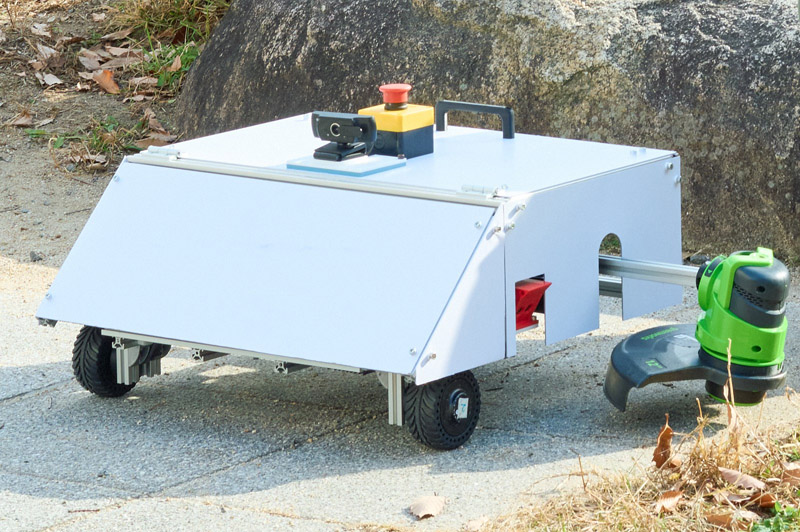
Compact roadside weeding robot R4
1. Introduction
In Japan, a large proportion of the road infrastructure was intensively constructed during the period of high economic growth, resulting in an increasing number of facilities that have been in service for over 50 years. Corrective maintenance performed after deterioration not only incurs high costs and requires long-term traffic restrictions but also carries risks such as structural collapse and personal injury. Therefore, road infrastructure management policies have shifted from corrective maintenance to preventive maintenance, which involves planned interventions before functional degradation becomes apparent. Technologies such as pavement crack detection using laser scanners 1,2 and concrete corrosion diagnosis using infrared thermography 3,4 have been proposed as part of preventive maintenance. The introduction of these technologies allows early detection of abnormalities that are easily overlooked by visual inspection, reducing the risk of collapse or unexpected functional failure.
Among preventive maintenance tasks, vegetation management along roadsides is critical to maintain road infrastructure performance. For example, when vegetation is left unchecked and the roots penetrate the roadside, they can lift the asphalt surface, causing cracks and potholes 5,6. Furthermore, the growth of vegetation can obstruct pedestrian and bicycle traffic and reduce the visibility of traffic signs 7. Therefore, regular weeding is essential for the safety and functional maintenance of roads. However, manual weeding is labor-intensive and safety is compromised under high temperatures in the summer or in traffic-exposed areas. Chronic labor shortages also make planned implementation difficult and increase maintenance costs. Although herbicide application is efficient in terms of area per unit of labor, it raises environmental concerns such as contamination and the evolution of herbicide-resistant weeds. Consequently, there is a demand for technologies that can automate roadside weeding while minimizing environmental impact.
Autonomous navigation robots have emerged as a promising solution to reduce human workload in outdoor operations. Unmanned aerial vehicles have been used for road patrols and bridge inspections, thereby reducing the risks associated with high-altitude work and reducing operational times 8,9. Autonomous robots have been reported to reduce the workload of nighttime snow removal 10,11. In agriculture, autonomous weeding robots, such as the Titan a, which selectively removes weeds while identifying crops, and robotic lawn mowers, such as the Automower b, which is designed for sports field maintenance, have been developed. Most of these systems are designed for agricultural or horticultural applications, assuming large machines for bulk weeding, known work areas, and the operation of weeding mechanisms on the soil. However, in roadside environments where drivable areas are restricted, a weeding robot that fulfills the following requirements must be designed: (1) the robot should have a compact design to minimize the risk of vehicle contact; (2) the robot should have the ability to autonomously generate a travel path in an outdoor environment; and (3) the robot should ensure safe operation of the weeding mechanism on asphalt surfaces. Existing weeding robots do not satisfy all of these requirements, making their operation in roadside environments challenging.
In this study, we propose a compact autonomous roadside weeding robot, R4 (Ritsumeikan Road-weed Removal Robot), for road infrastructure maintenance. The robot has a compact structure with a width of 603 mm, depth of 512 mm, and height of 368 mm, enabling its operation in roadside environments. By using a single RGB camera to detect the roadside and determine the travel path, the robot achieved autonomous navigation independent of lighting and pavement conditions. Furthermore, a weeding mechanism composed of nylon cords was deployed only when weeds were detected at the sides of the robot, allowing safe weeding without human intervention.
The contributions of this study are as follows:
-
The travel path is determined using only a single RGB camera mounted on the top of the robot, simplifying the sensor configuration and reducing cost.
-
A lightweight two-stage inference algorithm consisting of vegetation identification and weed area detection is introduced using synthetic data to improve generalization and reduce the inference time.
-
A control strategy is developed that deploys the weeding mechanism only when weeds are detected, improving energy efficiency while preventing safety hazards caused by unnecessary mechanism deployment.
-
Outdoor experiments were conducted to perform roadside weeding and verify the effectiveness of the weeding robot integrated with the proposed system in real-world conditions.
The remainder of this paper is organized as follows. Section 2 describes the related studies and positioning of this study. Section 3 explains the design of the proposed weeding robot, autonomous navigation system, and weed detection algorithm. Section 4 presents the experiments on autonomous navigation and weed detection as well as outdoor experiments to verify the practical applicability of the proposed robot. Section 5 discusses the experimental findings and future research directions. Finally, Section 6 concludes the study.
2. Related Studies
2.1. Weeding Robots
Weeding mechanisms can be classified into three types: chemical, thermal, and mechanical. As examples of chemical-type mechanisms, the ARA Field Sprayer (Ecorobotix Co.) identifies weeds between crop rows using cameras and sprays herbicides accordingly c, whereas the See & Spray system (John Deere Co.) optimizes the spray area by controlling the nozzles d. The LaserWeeder G2 (Carbon Robotics Co.) employs a thermal-type mechanism that irradiates weeds using a high-powered submillimeter-precision laser e. Examples of mechanical mechanisms include the Rover (ROMI Co.), which suppresses weed establishment through periodic shallow tillage f. In addition, Iwano et al. developed a compact weeding robot equipped with a flail-type mowing mechanism 12. Chemical-type systems raise concerns regarding their environmental impact, whereas thermal-type systems pose safety challenges. Considering both pedestrian safety and environmental impacts, mechanical weeding mechanisms are best suited for roadside environments.
Weeding robots equipped with mechanical weeding mechanisms have primarily been developed for agricultural and horticultural applications. The Titan weeding robot (FarmWise Co.) a targets only weeds within crop rows through visual processing, whereas the FD20 weeding robot (FarmDroid Co.) g enables precise weeding by memorizing seeding positions. Although large-scale weeding robots offer high operational efficiency, their size and weight make their operation difficult in roadside environments where drivable areas are limited. Compact weeding robots, such as the Automower (Husqvarna Co.) b and Landroid (Worx Co.) h weeding robots, achieve stable weeding operations using boundary line guidance and simple obstacle detection. However, because they assume known soil environments, they are not well-suited for roadside conditions that require weeding in unknown environments and on asphalt surfaces. In addition, compact robots face difficulties in continuous long-term operation due to battery capacity limitations, making a minimal sensor configuration and an efficient weeding mechanism design crucial.
2.3. Weed Detection Algorithm
The YOLO series is widely used as object detection models that balance real-time performance with detection accuracy. YOLO models estimate the object regions and class probabilities simultaneously, allowing them to operate on edge devices with limited computational resources. Among them, YOLOv8 i, which simplifies the inference mechanism through an anchor-free head, achieves a higher detection accuracy while maintaining lightweight performance. Recently, specialized models for weed detection in agricultural fields, such as YOLO-WDNet 20 and CSCW-YOLOv7 21, have been proposed. Although existing weed detection models are trained on top-view images, weeds along roadsides can only be captured from a lateral perspective. Moreover, considering the inference constraints of edge devices, reducing computational time and power consumption remains a significant challenge.
To specialize an object detection model for weed detection, fine-tuning with a weed image dataset is required. Publicly available research datasets include DeepWeeds 22, which contains eight wild weed species, and CWFID 23, which provides annotated images of weeds in cultivated fields. However, these datasets do not include images captured in roadside environments where asphalt and other heterogeneous backgrounds are present. Therefore, it is necessary to capture images of weeds along roadsides and construct a dedicated dataset. Furthermore, if the dataset is built only for a specific roadside environment, the generalization ability of the weed detection model may be reduced. To ensure robust performance across various environments, a large-scale dataset is required; however, the manual annotation of such data is costly.
2.4. Positioning of This Study
We have previously developed a compact autonomous weeding robot specialized for roadside environments 24. The developed three-wheeled robot measured 510 mm \(\times\) 670 mm \(\times\) 220 mm, weighed 11.6 kg, and was designed to operate without obstructing traffic, even on narrow roadsides. In the autonomous navigation system, the boundary line between the road and shoulder was detected using an RGB camera mounted in front of the robot as a robust feature against road surface degradation. Subsequently, a semantic segmentation model was developed to identify drivable areas, and a travel path was generated along the boundary line to achieve low-cost autonomous navigation without relying on GPS or LiDAR. In addition, an RGB-D camera mounted on the side captured the roadside area, and a weed-detection algorithm based on YOLOv8 was implemented to extract the weed regions. Based on the detected distance of the weeds, a nylon-cord weeding mechanism was deployed using an extendable arm, enabling safe and energy-efficient weeding operations.
Although our previous system demonstrated the fundamental functions of a roadside weeding robot, there are several issues that must be addressed for practical deployment. First, owing to imbalances in the center of gravity and the absence of an outer cover, autonomous navigation may become unstable. Second, navigation performance has not been sufficiently verified for diverse road geometries and long-distance travel. Third, the weed detection algorithm performs inference for weeding areas even in weed-free areas, resulting in additional computational time. Furthermore, the small size of the training dataset makes the model highly dependent on the specific image acquisition environment. Fourth, weeding tasks in real environments have only been verified in limited test sections.
In this study, we propose a practical roadside weeding robot that addresses these challenges. The hardware design is compact and durable for long-term outdoor operations. To ensure autonomous navigation, we evaluate the robot’s stability under complex curved paths indoors and verify its long-distance performance outdoors. For weed detection, we introduce a two-stage algorithm. The first stage performs lightweight vegetation presence classification, and the second stage detects weed regions using a lightweight version of YOLO, thereby reducing computational time. In addition, we construct a pseudo-weed dataset to enhance generalization performance. Finally, we conduct real-world experiments on autonomous navigation and roadside weeding tasks in outdoor environments.
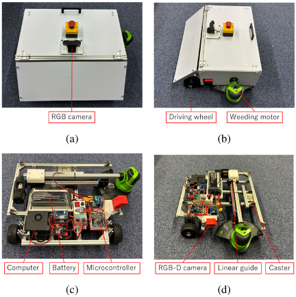
Fig. 1. Overview of the developed robot: (a) front view of the exterior, (b) side view of the exterior, (c) front view of the internal structure, and (d) side view of the internal structure.
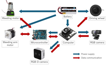
Fig. 2. Hardware configuration. The blue arrows indicate the power supply paths, and the red arrows indicate the data communication paths.
3. Roadside Weeding Robot
3.1. Hardware Configuration
Figure 1 shows the external appearance and internal structure of the proposed robot, and Fig. 2 illustrates its hardware configuration. The proposed robot has a width, depth, and height of 603, 512, and 368 mm, respectively, with a total weight of 16.4 kg. The robot has a three-wheel configuration consisting of two front drive wheels and a rear caster for maneuverability. The frame is made of lightweight yet rigid aluminum, achieving both durability in outdoor environments and ease of handling. An RGB camera is used for path planning during navigation. The camera is mounted on the upper front of the robot to provide a wide field of view in the forward direction while minimizing the robot’s shadow and interference from the weeding mechanism. An RGB-D camera installed on the left side of the robot is used for weed detection. To acquire positional information about the target weeds, the RGB-D camera is positioned slightly ahead of the weeding mechanism along the traveling direction, allowing sufficient processing time between detection and weeding. The weeding mechanism is mounted on the left side of the robot behind the RGB-D camera, enabling accurate alignment with the weeds identified by the camera. A LiPo battery is employed as the power source and is positioned at the center of the robot to maintain its stability during movement.
The onboard computer functions as the main processing unit of the robot, handling image processing for weed detection and path planning based on the camera images. It also controls the weeding mechanism and drives the wheels based on the processing results. Because image processing involves machine learning, a high computational performance is required. Simultaneously, reducing the overall weight of the system is important to improve mobility efficiency. To satisfy both requirements, we employ the Jetson Orin Nano (NVIDIA Co.), which features a high-performance GPU for an edge device and enables real-time processing while maintaining low power consumption.
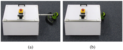
Fig. 3. Weeding mechanism: (a) active and (b) inactive.
For the mechanical weeding mechanism of the proposed robot, we employ the STG302 motor (Greenworks Co.) as the cutting unit. The motor is rotated at a no-load speed of 9000 rpm, and a nylon cord is attached to its spindle. The centrifugal force generated by the rotation is used to cut the weeds. Compared with metal blades, the nylon cord is lighter and poses a lower risk of kickback, providing greater safety for outdoor operations. In addition, the weeding mechanism is mounted at the tip of an extendable arm that can elongate up to 30 cm according to the position of the detected weeds. Fig. 3 shows the states of the weeding unit during operation and under idle conditions. A linear rail is used for the arm’s motion system, which allows the mechanism to reach weeds located slightly away from the robot’s body while reducing the risk of accidental contact when inactive. The operation of the weeding unit is controlled based on the weed detection results. Specifically, the weeding process begins when the side-mounted camera detects weeds continuously for three consecutive frames. The arm is extended according to the distance to the roadside edge, and the nylon cord is rotated to reach a sufficient cutting speed. Conversely, if no weeds are detected in 10 consecutive frames, the weeding motor decelerates and the arm retracts. This procedure prevents unnecessary interruptions caused by temporary detection losses and helps maintain the operational efficiency. Through this control flow, the system can operate the weeding mechanism efficiently and safely according to the spatial distribution of the weeds.
The proposed robot is equipped with two cameras as the visual sensors. Fig. 4 shows examples of the images captured by these cameras. First, the forward-facing RGB camera (WEBCAM-A001; Tinzzi Co.) is used to recognize the road conditions to determine the travel path. For real-time autonomous navigation, the frame rate is set to 5 fps and the image resolution is \(640 \times 480\) pixels. The RGB-D camera (RealSense Depth Camera D405; Intel Co.) mounted on the left side of the robot is used to detect weed regions and measure the distances. This camera is operated at 10 fps with an image resolution of \(640 \times 360\) pixels. The depth information is obtained based on disparity, and a spatial filter is applied to the resulting depth image to smooth it while preserving the edges. For roadside distance estimation, YOLO is first used to detect the bounding boxes corresponding to the weed class from the RGB image. Assuming that the roadside exists in the background behind the weeds, we obtain depth values within the 10% height band around the center of the bounding box. Because the depth sensors are prone to missing data and outliers in the foreground, the representative depth value is determined by considering the top 5% of the largest depth values within the band. This approach enables a stable estimation of the distance to the curb in the background.
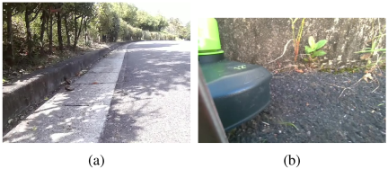
Fig. 4. Captured images: (a) front and (b) side.
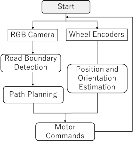
Fig. 5. Block diagram of the autonomous navigation system.
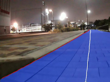
Fig. 6. Segmentation image. The blue region indicates the drivable area, the red line indicates the road boundary, and the white line indicates the planned travel path.
3.2. Autonomous Navigation
Figure 5 shows the block diagram of the autonomous navigation system of the proposed robot. First, the RGB camera mounted in front of the robot is used to detect the drivable road area. The left edge of the detected region is treated as the road boundary line. The boundary line points are then projected from the image coordinates onto the robot coordinates, and a travel path is generated by offsetting the boundary in the normal direction by a fixed distance. In addition, the rotational velocity obtained from the wheel encoders is used to estimate the robot’s heading direction and posture along the generated path. Finally, the motors are controlled using the Pure Pursuit algorithm 25 such that the robot follows the target path.
In this study, fast segment anything model (FastSAM) 26 is used to extract the road regions from the camera images via semantic segmentation. FastSAM combines the YOLOv8 architecture with a promptable segmentation function of the segment anything model, thereby enabling real-time segmentation. Fig. 6 shows an example of the segmented image. Because the RGB camera is mounted at the center of the robot, the region containing pixels in the lower central area of the image is regarded as the road region. To reduce noise, only the structure with the largest connected components is extracted after the dilation and erosion processing. In this study, we assume that the left edge of the road region corresponds to the road shoulder, and thus, the leftmost edge is treated as the set of boundary line points between the road and shoulder.
Because the boundary line points exist in the image coordinate system, they must be converted into a robot coordinate system. In this study, the ground plane is defined as \(z=0\), and the robot coordinate system is defined as an orthogonal coordinate system with its origin located at the midpoint between the two wheels of the robot. The camera coordinates \((X_C, Y_C, Z_C)\) for a pixel \((u, v)\) are given by
Following the obtained travel path, the driving mechanism is controlled using the Pure Pursuit algorithm. The Pure Pursuit algorithm is a control method that sets a look-ahead point along the target path at a fixed distance and determines the steering angle required to pass through that point. In this study, the look-ahead distance was empirically set to 0.4 m. This value was selected by considering the trade-off between the tracking stability and responsiveness during curved-path navigation. Segmentation inference can only be performed intermittently when the robot moves continuously. Therefore, the rotational speed is acquired from both wheel encoders, and the robot’s position and orientation are estimated continuously using odometry. When the segmentation inference is complete, the robot’s position and orientation are estimated, and the control is corrected based on them to ensure continuous travel without deviation from the travel path.
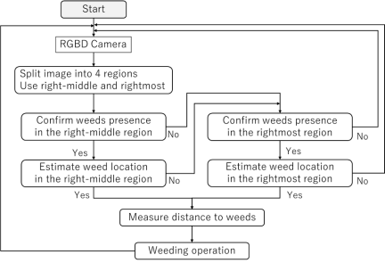
Fig. 7. Block diagram of the weed detection algorithm.
3.3. Weed Detection Algorithm
In this study, we propose a lightweight and high-speed weed detection algorithm. In the first stage, a lightweight binary classification gate is used to determine the presence or absence of weeds and distribute the computational processing load. The system proceeds to the second stage only when weeds are detected, and a lightweight YOLO model estimates the position and confidence scores of the detected weeds. When no weeds are detected, the subsequent object detection stage is skipped, thereby reducing the computational cost. Fig. 7 shows the block diagram of the proposed method. First, the image captured by the side-mounted camera is divided into four sections. A 10% overlap margin is applied between adjacent regions to avoid missing weeds near the division boundaries. In this study, only two right-segmented images are used, excluding the weeding mechanism and its shadow. The two-stage detection process is first applied to the left segment near the weeding mechanism. If no weeds are detected, the same process is applied to the right segment. This structure reduces the computational cost in weed-free areas and enables real-time processing on the edge devices.
For the first-stage weed identification, a lightweight binary classifier based on MobileNetV3 27 is adopted. MobileNetV3 features an efficient architecture using depthwise separable convolutions and a hard-swish activation function, making it suitable for fast inference on edge devices. In this study, we replace the final classification layer of a pretrained MobileNetV3-Small (trained on ImageNet 28) with a two-class classifier: “Weed” and “None.” The input images are resized to \(224 \times 224\) pixels, and the class probabilities are output using a softmax function. The training dataset consists of 480 images with weeds and 480 images without weeds, all of which are captured using the side-mounted camera. During training, only the classifier layer is fine-tuned at a learning rate of \(3 \times 10^{-4}\). The maximum number of epochs is set to 15, and the model from the epoch that yields the best validation performance is selected.
For the second-stage object detection, YOLO11 29 is adopted to achieve a balance between small-object detection performance and real-time operation. However, to ensure efficient inference on edge devices, the network structure is partially modified to reduce its size. In the proposed model, the P5 layer, which mainly contributes to large-object detection, replaces its standard convolutional layers with GhostConv 30 and reduces the number of output channels from 1024 to 768. GhostConv first generates a small number of feature maps using a standard convolutional layer and then applies low-cost transformations to increase the correlation between these maps. This enables efficient model size reduction while maintaining accuracy in the P5 region with a low spatial resolution. For the P4 layer and subsequent layers, which are crucial for medium- and small-object detection, the block structure and channel widths remain unchanged. To further improve the processing speed, the input image size is reduced to \(320 \times 320\) pixels.
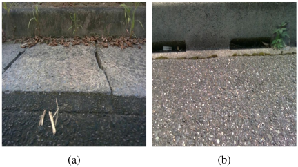
Fig. 8. Training dataset: (a) real images and (b) synthetic images.
The object detection model is trained using a dataset composed of real and synthetic images. Fig. 8 shows examples of the real and synthetic images. The real dataset includes 299 images of roadside scenes with and without weeds. Each image is manually annotated with rectangular bounding boxes around the weed regions, excluding off-road vegetation and background noise. However, because real images alone do not provide sufficient diversity in weed appearance or background conditions, 580 synthetic images are added. To generate these synthetic images, the GrabCut algorithm 31 is first used to remove background components from the real weed images, producing foreground images containing only weeds. Images of the roadside environments without weeds are used as the background images. To enhance robustness, the background dataset includes challenging elements such as drainage channels and pavement joints, which may induce false detections. The foreground weed images are then pasted onto the background images along the roadside boundary line, and random scaling is applied to create diverse combinations. Finally, the model is trained in two stages: pretraining on the synthetic images, followed by fine-tuning on the real images. This two-stage training strategy enables the construction of a generalizable and robust object detection model capable of operating reliably in unseen outdoor environments, even with limited computational resources. The initial training is executed for 200 epochs, followed by 100 epochs of fine-tuning on real data using the Adam optimizer. The model from the epoch with the best validation performance is selected as the final version.
4. Experiments
4.1. Autonomous Navigation System
A series of traveling experiments was conducted in indoor environments to evaluate the autonomous navigation performance of the proposed robot. The proposed robot was intended to operate on the roadsides in Japan. According to the Japanese road design standards, the curvature of typical road alignments usually remains below 0.1. However, roadside weeds can also grow along more complex roadside geometries with higher curvatures. If the robot can autonomously navigate in such environments, its applicability to a wider range of roadside weeding tasks can be demonstrated. Therefore, indoor experiments were designed to evaluate the navigation performance of the proposed robot for roadside geometries with curvatures greater than 0.1.
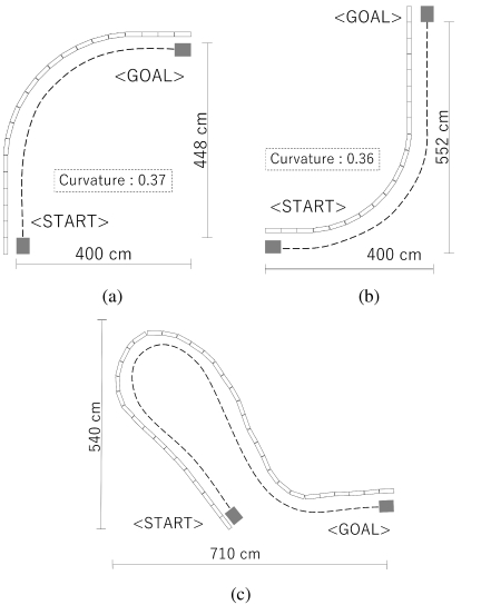
Fig. 9. Experimental environments for autonomous navigation: (a) indoor environment A, (b) indoor environment B, and (c) indoor environment C.
As shown in Fig. 9, three types of course maps were prepared by arranging blocks with a height, length, and width of 19, 39, and 10 cm, respectively. Indoor environment A consisted of a course with a right-hand curve, indoor environment B included a left-hand curve, and indoor environment C featured a composite course that combined right-hand and left-hand curves. For each course pattern, the robot performed five test runs with its initial position adjusted to align with the wall before each trial. During the experiments, a distance sensor was mounted on the left side of the robot to measure its lateral distance from the wall during autonomous navigation. The travel speed of the robot was set to 0.25 m/s.
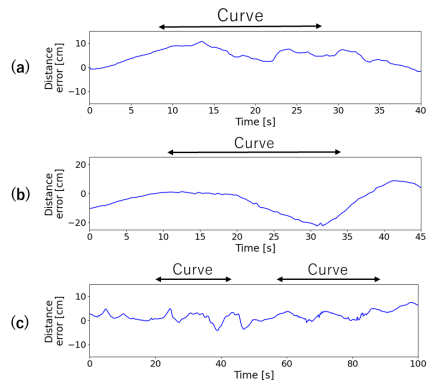
Fig. 10. Distance error relative to the target distance: (a) indoor environment A, (b) indoor environment B, and (c) indoor environment C.
Indoor experiments were conducted on a carpet-like floor surface. Because this surface differs from real roadside surfaces (such as asphalt or concrete) in terms of friction characteristics and surface conditions, the results should not be interpreted as a precise reproduction of real road surface conditions. The purpose of the indoor experiments was to examine the basic navigation behavior of the proposed system when following boundary geometries including curved sections.
Figure 10 shows the distance error relative to the target distance. The mean error over five runs was calculated for each course pattern. In indoor environment A, which included a right-hand curve, the robot tended to drift outward as it entered the curve, thereby increasing the distance error from the block. Similarly, in indoor environment B, which included a left-hand curve, the robot temporarily approached the block as it lost sight of the block during sharp turns. However, in the straight section, from the start of the experiment to 20 s after the experiment commenced in indoor environment B, the robot maintained a stable trajectory while continuously adjusting its distance from the wall. Furthermore, after 37 s in indoor environment A, and after 42 s in indoor environment B, compensatory behavior was observed as the robot attempted to correct the accumulated error after passing the curves. In indoor environment C, the distance errors increased at 21 s (right-hand curve entry) and 58 s (left-hand curve entry). Overall, the robot successfully achieved stable autonomous navigation throughout the course. Although an increase in temporary error was observed during curve entry, the results confirmed that the robot maintained stable traveling performance on straight sections.
4.2. Weed Detection Algorithm
We verified the effectiveness of the proposed weed detection algorithm. As a baseline, a YOLO11n model pretrained on the COCO dataset 32 was fine-tuned using real-world data. The evaluation metrics were mAP@0.5, recall at a YOLO confidence threshold of 0.25, number of model parameters (M), and processing time [ms]. The processing time was measured as both the average and minimum values using the Jetson Orin Nano computer. The input image size for the YOLO model was set to \(320 \times 320\) pixels.
Table 1 shows the experimental results. The baseline model (YOLO11) was compared with three variants: one trained with synthetic images (Synthetic), one using a lightweight version of YOLO (Lightweight), and one incorporating a lightweight weed classification module (Gate). The introduction of synthetic data improved the recall from 0.79 to 0.81, demonstrating that the number of missed detections of weeds was reduced. The lightweight YOLO model decreased the mAP and recall to 0.70 and 0.77, respectively; however, the model reduced the number of parameters by 30%. The model with the weed classification module decreased the mAP and recall to 0.60 and 0.71, respectively; however, the average inference time was significantly reduced to 18.5 ms, with a minimum inference time of 5.3 ms. Due to the two-stage inference structure, the number of YOLO calls was reduced to 23% of the total, suggesting a trade-off between inference performance and computational time. The ablation experiments confirmed that, although the mAP decreased compared with the baseline, the introduction of synthetic data improved the recall and the addition of the weed classification module significantly reduced the inference time.
Table 1. Results of the ablation experiments.

4.3. Field Experiments in Outdoor Environments
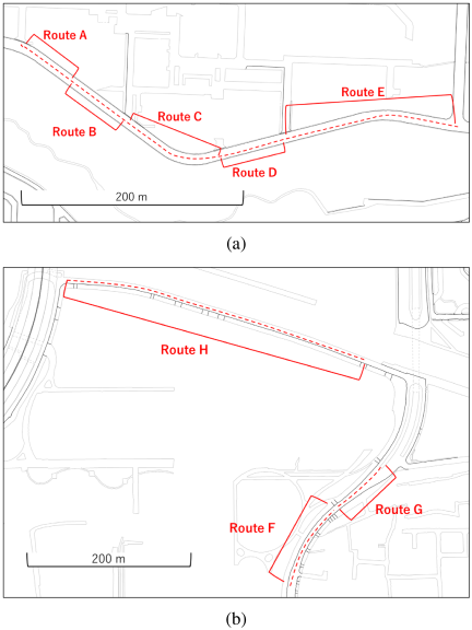
Fig. 11. Experimental environments for autonomous navigation: (a) outdoor environment A and (b) outdoor environment B.
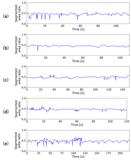
Fig. 12. Segmented road area ratio for (a) route A, (b) route B, (c) route C, (d) route D, and (e) route E.
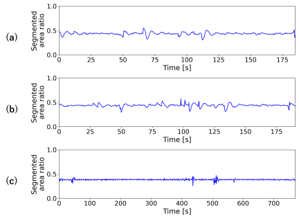
Fig. 13. Segmented road area ratio for (a) route F, (b) route G, and (c) route H.
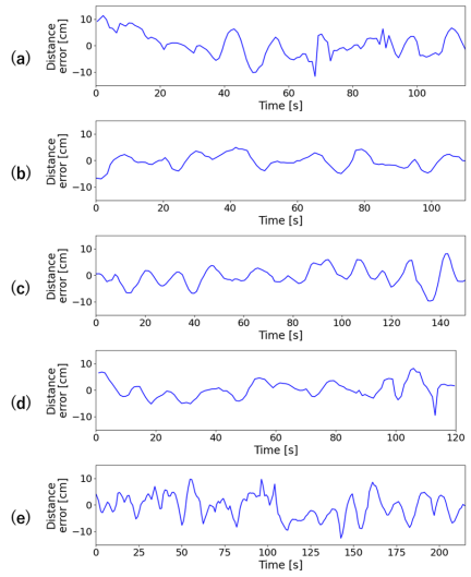
Fig. 14. Distance error relative to the target distance for (a) route A, (b) route B, (c) route C, (d) route D, and (e) route E.
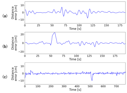
Fig. 15. Distance error relative to the target distance for (a) route F, (b) route G, and (c) route H.
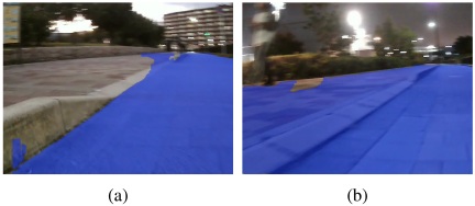
Fig. 16. Segmentation results with a large distance error in outdoor environment B for (a) route G at 48 s and (b) route H at 510 s.
First, we evaluated the performance of autonomous navigation in real-world environments. As shown in Fig. 11, the experiments were conducted on paved roads surrounding two university campuses.
Outdoor environment A was characterized by fallen leaves and vegetation, making it difficult to distinguish the boundary line between the roadside and pavement. The experiments were conducted in this environment during daytime. In contrast, outdoor environment B had a clean roadside. However, for route H, which was illuminated by streetlights, the experiments were conducted after sunset to evaluate the performance under low-light conditions. During all experiments, the travel speed was set to 0.50 m/s, and the distance error relative to the roadside was measured.
Before discussing the tracking error, we evaluated the recognition stability of the road region in outdoor environments. Since the proposed method generates the travel path based on the left edge of the segmented road region, stable segmentation is important for stable boundary extraction and path generation. Therefore, the temporal variation of the segmented road area ratio was analyzed as a simple indicator of segmentation stability. Figs. 12 and 13 show the segmented road area ratios in outdoor environments A and B, respectively, including all navigation routes in each environment. The results indicated that the segmented road area ratio tended to be more stable in outdoor environment B compared with in outdoor environment A, which was consistent with the clearer roadside boundary in outdoor environment B. Comparison with the distance error results suggests that, particularly in outdoor environment B, the tracking error increased at around the same time as the changes in the segmented road area ratio. These results indicated that segmentation stability affected boundary extraction and path generation, and that the proposed method achieved sufficiently stable autonomous navigation under the tested outdoor conditions.
Figures 14 and 15 show the distance errors for environments A and B, respectively. In environment A, where the roadside was indistinct and it was difficult to determine a clear boundary line, the distance error tended to fluctuate. Nevertheless, the overall error remained within 10 cm, indicating successful tracking of the roadside boundary line. In environment B, the autonomous navigation was stable throughout, and the distance error remained within 5 cm for most sections. Stable autonomous navigation was also achieved under streetlight illumination after sunset. These results confirmed that, regardless of the roadside conditions or lighting environments, the proposed robot maintained stable autonomous navigation at the target velocity, maintaining a distance error of 10 cm.
Although the overall tracking performance in outdoor environment B remained stable, large distance errors were observed locally. The segmentation results for these intervals are shown in Fig. 16. During these intervals, the curb temporarily disappeared from view, and the segmentation became unreliable, resulting in incorrect estimates of the road boundary. This shifted the extracted boundary line and generated an incorrect travel path. Because the deviations were observed only over a short interval and the tracking recovered afterward, this error was interpreted as a local and temporary recognition failure rather than a persistent limitation of the proposed navigation method.
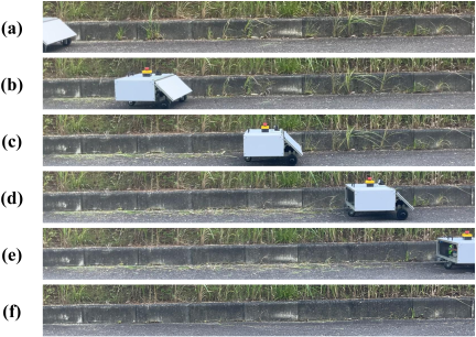
Fig. 17. Weeding operation in roadside environment A: (a) before weeding, (b) after 14 s, (c) after 27 s, (d) after 38 s, (e) after 50 s, and (f) after weeding.
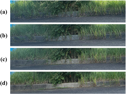
Fig. 18. Weeding operation in roadside environment B: (a) before weeding, (b) after first pass, (c) after second pass, and (d) after third pass.
Subsequently, we evaluated the weeding performance of the proposed robot in two roadside environments. In roadside environment A, which consisted of a 4.90 m straight roadside with 18 patches of vegetation, the weeding performance was tested in a single operation. Fig. 17 shows the weeding process in roadside environment A. The weeds that had grown before the operation were cut properly after the robot passed over them. Consequently, more than 90% of the weeds were removed, demonstrating effective weeding during autonomous navigation. The dense clusters of weeds appearing at 14 and 38 s were also successfully removed, indicating that sufficient weeding could be achieved in a single pass. Roadside environment B consisted of a 5.30 m straight roadside fully covered with vegetation. Because one pass was insufficient to complete the weeding, the robot performed three passes along the same route. Fig. 18 shows the weeding process in roadside environment B. After the first pass, weeds still remained throughout the area, suggesting that the thin nylon cord alone was insufficient to cut through dense weeds. During the second and third passes, proper weeding was observed in several sections, particularly in the first half of the path. This demonstrated that the proposed robot could adapt to densely vegetated areas through multiple passes. However, weeds remained in the latter sections, which was likely because of nylon cord wear during earlier operations, preventing the cord tips from reaching the weed bases. Overall, these results confirmed that the proposed robot effectively performed autonomous weeding in real environments and could adapt to varying weed densities by conducting one or more passes as necessary.
5. Discussion
In the indoor experiments, the proposed robot exhibited an outward deviation on the right-hand curves and a tendency to approach the wall too closely on the left-hand curves. Based on the observed transient distance errors at the curve entry, particularly the asymmetric behavior between the right-hand and left-hand curves, we further examined the geometric visibility of the boundary line. It shall be noted that the robot followed the boundary line on its left-hand side and did not explicitly estimate its path curvature. Owing to this configuration, the visibility of the boundary ahead became asymmetric, depending on the turn direction. Fig. 19 shows the images from the front camera during the curves. In the right-hand curves, the boundary line ahead remained within the camera’s field of view, allowing the controller to respond smoothly to the upcoming change in direction. In contrast, in the left-hand curves, the boundary ahead was partially occluded and could not be observed sufficiently in advance, which made the perceived boundary geometry change more abruptly and destabilized the distance control with respect to the wall. Furthermore, in the composite path, although the error temporarily stabilized in straight sections, the error increased again when the robot entered a curve. Because the current control algorithm does not sufficiently account for curve prediction, the introduction of predictive control is expected to be effective. In future work, we intend to conduct the following activities. First, we plan to revise the camera installation position and field of view to ensure stable boundary detection during curve navigation. Second, we intend to reduce the travel speed appropriately when the robot enters a curve to secure a sufficient response margin in control. Finally, we plan to incorporate predictive control that recognizes the path geometry in advance and performs corrections according to the curve radius.
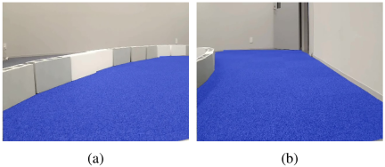
Fig. 19. Asymmetric visibility of the boundary in curves: (a) right-hand curve and (b) left-hand curve.
In the evaluation experiments of the weed detection algorithm, the configuration with added synthetic data showed a decrease of 0.02 points in the mAP@0.5, whereas the recall improved by 0.02 points. This suggests that although the difference in data distribution between the real and synthetic images increases the number of false detections, the synthetic images complement diverse backgrounds and weed patterns, reducing the number of missed detections. Therefore, improving the quality of synthetic data and introducing domain adaptation techniques can further enhance the detection accuracy. In addition, the lightweight YOLO11n model reduced the number of parameters by approximately 30% and reduced the inference time by 1.7 ms. However, because the reduction in model size reduced its feature representation capacity, the mAP and recall decreased to 0.70 and 0.77, respectively. Model compression contributes to the real-time performance of edge devices; however, to minimize accuracy degradation, additional techniques such as knowledge distillation training and architecture optimization are required. Moreover, the introduction of a two-stage inference method resulted in the shortest average and minimum inference times, where the mAP and recall dropped to 0.60 and 0.71, respectively, which were the lowest values among all models. These results suggest that false classifications by the weed discrimination model likely increase the number of missed weeds. Hence, we consider optimizing the thresholds and improving the accuracy of the discrimination model in the future. Based on these findings, a flexible model configuration system that can be adapted to the hardware performance and local weed environments is ideal. In the future, constructing a system that automatically switches models according to environmental information and weed distribution will enable more efficient and practical weed identification.
In the performance evaluation of the autonomous navigation method in outdoor environments, we confirmed that the visibility of the roadside affected the recognition accuracy. In particular, when fallen leaves were present along the roadside, the uncertainty in the boundary line detection reduced the stability of the algorithm. In contrast, in environments with clearly defined roadsides, the error remained generally stable, and autonomous navigation stability was maintained regardless of the lighting conditions. In addition, at locations where curbs or pavement steps were temporarily absent, the RGB camera alone could not uniquely determine the boundary line, resulting in unstable traveling. In the outdoor experiments, the observed deviations from the target path can be classified into three categories: perception errors, transient control responses, and geometric changes in the perceived boundary. First, in outdoor environment A, the perception uncertainty was the dominant source of error because ambiguous roadside boundaries caused fluctuations in the extracted boundary lines. Second, in outdoor environment B, where the boundary recognition was generally stable, most deviations were attributed to the transient control response to abrupt changes in the perceived boundary geometry. Third, the proposed method did not explicitly estimate path curvature, and therefore, changes in the path curvature affected the robot’s behavior indirectly through changes in the perceived boundary geometry, rather than as a separate control input. Therefore, addressing the issues related to perception, control, and geometry is necessary to further improve the stability of autonomous navigation in practical roadside environments.
The use of a single RGB camera was a deliberate design choice to achieve a low-cost and simple navigation system. The proposed method worked effectively when the roadside boundary (such as a curb, pavement edge, or road shoulder) was at least partially visible in the camera image. However, the robustness of the method decreased when the boundary became visually ambiguous due to fallen leaves, dense weeds, shadows, low illumination, or the temporary disappearance of curbs or pavement steps. In such cases, the segmentation results may fluctuate, leading to unstable boundary extraction and path generation. Therefore, in the future, we will retain the RGB camera as the main sensing device; at the same time, we will implement simple and low-cost auxiliary sensors (such as proximity or distance sensors) only in failure-prone situations. This will improve robustness without sacrificing the simplicity, low cost, or real-time performance of the system.
Through the integration of autonomous navigation and a weeding mechanism, the proposed robot demonstrated high weeding performance in a single pass. However, the nylon cutting cord wore down over time, preventing the blade tips from reaching the weed roots. This indicates that although the proposed robot shows a certain degree of adaptability in dense environments, it is necessary to improve the robot for long and high-load operations. Even though wear detection and automatic replenishment mechanisms are possible countermeasures, frequent wear can increase the system’s complexity and maintenance requirements. Therefore, in future work, we will consider not only improved wear management but also alternative approaches (such as changing the blade material, optimizing the rotational speed, and re-examining the cutting method itself), to achieve a better balance between safety, durability, and long-term practicality. The proposed distance estimation method was effective when the curb was at least partially visible in the camera’s field of view. In the roadside experiments, the curb remained partially visible behind the weeds, and the proposed distance estimation method functioned without critical problems. However, we expect that the robot’s robustness will decrease in densely vegetated roadside environments, where the curb may be fully occluded.
In the current system, the cut weeds were not actively collected after removal. Although leaving the cut weeds on the roadside did not cause a critical problem in the experiments, residual cut weeds may affect subsequent visual detection or roadside maintenance in practical operations. Therefore, in future work, we will devise a cooperative framework involving a separate robot for collecting cut weeds, which may lead to a multi-robot roadside maintenance system.
Based on the outdoor experimental results, the average power consumption of the proposed robot during the weeding operations was 132 W. This value was estimated from the voltage drop of the onboard LiPo battery during the continuous weeding operation and should be regarded as an approximate estimate rather than a precise measurement. The robot was equipped with a six-cell LiPo battery with a nominal voltage of 22.2 V and a capacity of 22 Ah. Calculations based on the total theoretical energy in the fully charged state indicated a continuous operating time of more than 3 h and 40 min. Therefore, it can be deduced that the proposed robot is practical for real-world weeding operations. Because this value was obtained in a densely vegetated environment, the power consumption was expected to decrease, and the operating time was expected to increase under lighter load conditions with lower weed density. However, in actual use, the operating time may be reduced due to load fluctuations, system efficiency degradation, and maintenance of battery safety margins. In future work, it will be necessary to quantitatively evaluate power consumption variations caused by differences in weed density and navigation environments and to optimize the power system accordingly.
6. Conclusion
In this study, we proposed a compact autonomous roadside weeding robot for road infrastructure maintenance. Experiments were conducted to evaluate the performance of the autonomous navigation system, weed detection algorithm, and weeding operations in real environments. The experimental results demonstrated that the robot could stably travel along roadsides with clearly defined boundary lines, detect weed areas within a short time, and successfully remove most of the actual vegetation. However, several challenges remain, including the stability of autonomous navigation in complex roadside environments, the trade-off between weed detection accuracy and inference time, and weeding performance in areas with dense vegetation. In future work, we intend to introduce predictive control, improve the accuracy of the weed identification model, and enhance the durability of the weeding mechanism.
Acknowledgments
This study was supported by the Ritsumeikan Global Innovation Research Organization.
- [1] N. Kheradmandi and V. Mehranfar, “A critical review and comparative study on image segmentation-based techniques for pavement crack detection,” Construct. Build Mater., Vol.321, Article No.126162, 2022. https://doi.org/10.1016/j.conbuildmat.2021.126162
- [2] T. Cao, Y. Wang, and S. Liu, “Pavement Crack Detection Based on 3D Edge Representation and Data Communication with Digital Twins,” IEEE Trans. Intell. Transp. Syst., Vol.24, No.7, pp. 7697-7706, 2023. https://doi.org/10.1109/TITS.2022.3194013
- [3] B. Goffin, N. Banthia, and N. Yonemitsu, “Use of infrared thermal imaging to detect corrosion of epoxy coated and uncoated rebar in concrete,” Construct. Build Mater., Vol.263, Article No.120162, 2020. https://doi.org/10.1016/j.conbuildmat.2020.120162
- [4] E. Ichi and S. Dorafshan, “Effectiveness of infrared thermography for delamination detection in reinforced concrete bridge decks,” Autom. Constr., Vol.142, Article No.104523, 2022. https://doi.org/10.1016/j.autcon.2022.104523
- [5] S. M. Blunt, “Trees and pavements—Are they compatible?,” Arboric. J., Vol.31, No.2, pp. 73-80, 2008. https://doi.org/10.1080/03071375.2008.9747522
- [6] F. Giuliani, F. Autelitano, E. Degiovanni, and A. Montepara, “DEM modelling analysis of tree root growth in street pavements,” Int. J. Pavement Eng., Vol.18, No.1, pp. 1-10, 2017. https://doi.org/10.1080/10298436.2015.1019495
- [7] P.-R. Hirt, J. Holtkamp, L. Hoegner, Y. Xu, and U. Stilla, “Occlusion detection of traffic signs by voxel-based ray tracing using highly detailed models and MLS point clouds of vegetation,” Int. J. Appl. Earth Obs. Geoinform., Vol.114, Article No.103017, 2022. https://doi.org/10.1016/j.jag.2022.103017
- [8] R. Li, J. Yu, F. Li, R. Yang, Y. Wang, and Z. Peng, “Automatic bridge crack detection using Unmanned aerial vehicle and Faster R-CNN,” Construct. Build Mater., Vol.362, Article No.129659, 2023. https://doi.org/10.1016/j.conbuildmat.2022.129659
- [9] J. Zhu, Y. Wu, and T. Ma, “Multi-Object Detection for Daily Road Maintenance Inspection with UAV Based on Improved YOLOv8,” IEEE Trans. Intell. Transp. Syst., Vol.25, No.11, pp. 16548-16560, 2024. https://doi.org/10.1109/TITS.2024.3437770
- [10] M. Saska, M. Hess, and K. Schilling, “Efficient airport snow shoveling by applying autonomous multi-vehicle formations,” Proc. of 2008 IEEE Int. Conf. Robot. Autom, pp. 1684-1690, 2008. https://doi.org/10.1109/ROBOT.2008.4543443
- [11] J. Wu, L. Liu, Q. Wu, J. He, and W. Li, “Autonomous Robotic System for Snow Removal in Large-Scale Photovoltaic Arrays,” IEEE Access, Vol.13, pp. 141547-141559, 2025. https://doi.org/10.1109/ACCESS.2025.3597534
- [12] Y. Iwano, A. Tanaka, and K. Iizuka, “Development of a Flail-Type Mowing System,” J. Robot. Mechatron., Vol.37, No.3, pp. 555-562, 2025. https://doi.org/10.20965/jrm.2025.p0555
- [13] D. He, H. Li, and J. Yin, “LIGO: A Tightly Coupled LiDAR-Inertial-GNSS Odometry Based on a Hierarchy Fusion Framework for Global Localization with Real-Time Mapping,” IEEE Trans. Robot., Vol.41, pp. 1224-1244, 2025. https://doi.org/10.1109/TRO.2025.3530298
- [14] W. Yuan, Z. Li, and C.-Y. Su, “RGB-D sensor-based visual SLAM for localization and navigation of indoor mobile robot,” Proc. of 2016 Int. Conf. Adv. Robot. Mechatron., pp. 82-87, 2016. https://doi.org/10.1109/ICARM.2016.7606899
- [15] T. Shan, B. Englot, C. Ratti, and D. Rus, “LVI-SAM: Tightly-coupled Lidar-Visual-Inertial Odometry via Smoothing and Mapping,” Proc. of 2021 IEEE Int. Conf. Robot. Autom., pp. 5692-5698, 2021. https://doi.org/10.1109/ICRA48506.2021.9561996
- [16] U. Franke, D. Gavrila, S. Gorzig, F. Lindner, F. Puetzold, and C. Wohler, “Autonomous driving goes downtown,” IEEE Intell. Syst. Appl., Vol.13, No.6, pp. 40-48, 1998. https://doi.org/10.1109/5254.736001
- [17] M. Aly, “Real time detection of lane markers in urban streets,” Proc. of 2008 IEEE Intell. Veh. Symp., pp. 7-12, 2008. https://doi.org/10.1109/ivs.2008.4621152
- [18] M. Bojarski, D. Del Testa, D. Dworakowski, B. Firner, B. Flepp, P. Goyal, L. D. Jackel, M. Monfort, U. Muller, J. Zhang, X. Zhang, J. Zhao, and K. Zieba, “End to End Learning for Self-Driving Cars,” arXiv preprint, arXiv:1604.07316, 2016. https://doi.org/10.48550/arXiv.1604.07316
- [19] V. Badrinarayanan, A. Kendall, and R. Cipolla, “SegNet: A Deep Convolutional Encoder-Decoder Architecture for Image Segmentation,” IEEE Trans. Pattern Anal. Mach. Intell., Vol.39, No.12, pp. 2481-2495, 2017. https://doi.org/10.1109/tpami.2016.2644615
- [20] X. Fan, T. Sun, X. Chai, and J. Zhou, “YOLO-WDNet: A lightweight and accurate model for weeds detection in cotton field,” Comput. Electron. Agric., Vol.225, Article No.109317, 2024. https://doi.org/10.1016/j.compag.2024.109317
- [21] K. Wang, X. Hu, H. Zheng, M. Lan, C. Liu, Y. Liu, L. Zhong, H. Li, and S. Tan, “Weed detection and recognition in complex wheat fields based on an improved YOLOv7,” Front. Plant Sci., Vol.15, Article No.1372237, 2024. https://doi.org/10.3389/fpls.2024.1372237
- [22] A. Olsen, D. A. Konovalov, B. Philippa, P. Ridd, J. C. Wood, J. Johns, W. Banks, B. Girgenti, O. Kenny, J. Whinney et al., “DeepWeeds: A multiclass weed species image dataset for deep learning,” Scientific Reports, Vol.9, No.1, Article No.2058, 2019. https://doi.org/10.1038/s41598-018-38343-3
- [23] S. Haug and J. Ostermann, “A crop/weed field image dataset for the evaluation of computer vision based precision agriculture tasks,” Proc. of 2014 Eur. Conf. Comput. Vis., pp. 105-116, 2014. https://doi.org/10.1007/978-3-319-16220-1_8
- [24] Y. Matsushita, K. K. Gupta, Y. Fujii, D. T. Tran, and J.-H. Lee, “Development of an Autonomous Weeding Robot for Roadside Weeds,” Proc. of 2025 Int. Conf. Ubiquitous Robot., pp. 444-450, 2025. https://doi.org/10.1109/UR65550.2025.11078083
- [25] R. Wallace, A. Stentz, C. Thorpe, H. Moravec, W. Whittaker, and T. Kanade, “First Results in Robot Road-Following,” Proc. of 9th Int. Jt. Conf. Artif. Intell., Vol.2, pp. 1089-1095, 1985.
- [26] X. Zhao, W. Ding, Y. An, Y. Du, T. Yu, M. Li, M. Tang, and J. Wang, “Fast segment anything,” arXiv preprint, arXiv:2306.12156, 2023. https://doi.org/10.48550/arXiv.2306.12156
- [27] A. Howard, M. Sandler, B. Chen, W. Wang, L.-C. Chen, M. Tan et al., “Searching for mobilenetv3,” Proc. of 2019 IEEE/CVF Int. Conf. Comput. Vis., pp. 1314-1324, 2019. https://doi.org/10.1109/iccv.2019.00140
- [28] O. Russakovsky, J. Deng, H. Su, J. Krause, S. Satheesh, S. Ma, Z. Huang, A. Karpathy, A. Khosla, M. Bernstein et al., “Imagenet large scale visual recognition challenge,” Int. J. Comput. Vis., Vol.115, No.3, pp. 211-252, 2015. https://doi.org/10.1007/s11263-015-0816-y
- [29] R. Khanam and M. Hussain, “Yolov11: An overview of the key architectural enhancements,” arXiv preprint, arXiv:2410.17725, 2024. https://doi.org/10.48550/arXiv.2410.17725
- [30] K. Han, Y. Wang, Q. Tian, J. Guo, C. Xu, and C. Xu, “Ghostnet: More features from cheap operations,” Proc. of 2020 IEEE/CVF Conf. Comput. Vis. Pattern Recognit., pp. 1580-1589, 2020. https://doi.org/10.1109/cvpr42600.2020.00165
- [31] C. Rother, V. Kolmogorov, and A. Blake, ““GrabCut” interactive foreground extraction using iterated graph cuts,” ACM Trans. Graph., Vol.23, No.3, pp. 309-314, 2004. https://doi.org/10.1145/1015706.1015720
- [32] T.-Y. Lin, M. Maire, S. Belongie, J. Hays, P. Perona, D. Ramanan, P. Dollár, and C. L. Zitnick, “Microsoft coco: Common objects in context,” 2014 Eur. Conf. Comput. Vis., pp. 740-755, 2014. https://doi.org/10.1007/978-3-319-10602-1_48
- [a] “Farm Wise.” https://farmwise.io/ [Accessed October 13, 2025]
- [b] “Robot Lawn mowers.” https://www.husqvarna.com/us/robotic-lawn-mowers/ [Accessed October 13, 2025]
- [c] “ARA Field Sprayer.” https://ecorobotix.com/crop-care/ara-field-sprayer/ [Accessed October 13, 2025]
- [d] “See & Spray.” https://www.deere.com/en/sprayers/see-spray/ [Accessed October 13, 2025]
- [e] “LASERWEEDER G2.” https://carbonrobotics.com/laserweeder-g2 [Accessed October 13, 2025]
- [f] “The Rover for Weeding.” https://romi-project.eu/tools/weeding/ [Accessed October 13, 2025]
- [g] “FarmDroid FD20.” https://farmdroid.com/products/farmdroid-fd20/ [Accessed October 13, 2025]
- [h] “Landroid robot lawnmower by Worx.” https://eu.worx.com/en/landroid/ [Accessed October 13, 2025]
- [i] “ultralytics ultralytics.” https://github.com/ultralytics/ultralytics [Accessed October 13, 2025]
This article is published under a Creative Commons Attribution-NoDerivatives 4.0 Internationa License.