
Paper:
Empirical Evaluation of Activity Coordination Among Field Response Agencies Using ICT Solutions
Kazuo Tsutsui*,**,†, Machiko Iida**, Hayato Kudo*,**, Takeshi Isono*,**, Kazushiro Yoshimori*,**, Kenichi Takahashi*, Hiroaki Sano*,**
 , and Tadashi Ise*,**
*Research Division for Disaster Information and Intelligence, National Research Institute for Earth Science and Disaster Resilience (NIED)
3-1 Tennodai, Tsukuba, Ibaraki 305-0006, Japan
**Collaborative Research Center for Advanced Resilience Technology, National Research Institute for Earth Science and Disaster Resilience (NIED)
Tsukuba, Japan
†Corresponding author

This study empirically evaluates ICT-based coordination among Japanese disaster response agencies during the acute life-saving phase. Although national guidelines mandate inter-agency cooperation, agencies (fire services, police, and Self-Defense Forces) operate as self-contained silos with few joint verification drills. To overcome this structural barrier, we conducted two empirical experiments in FY2025. The first, a joint rescue drill in Aichi Prefecture evaluating a three-tiered coordination structure (prefecture, municipality, and field command), verified system functions for facilitating smooth activity coordination among response agencies. The second, a regional joint drill in the Chubu block testing cross-system data integration, focused on the real-time acquisition and layer-overlay sharing of vehicle passage records on SIP4D-Xedge and SOBO-WEB to secure access routes to isolated areas. Post-drill surveys and observational analysis confirmed high coordination achievement, demonstrating that a common operational picture (COP) was positively evaluated by participants and suggested the potential to support situational visibility and operational area division. Moreover, key technical requirements were identified, including offline caching/synchronization against tunnel communication blackouts and standardized UI symbology across agencies. Ultimately, effective coordination requires standardized sharing rules, platform integration into routine operations, and robust COP generation visualizing unit capabilities and passage records to accelerate life-saving efforts.
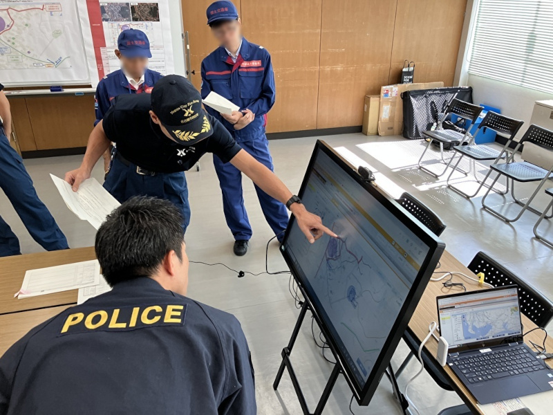
Multi-agency coordination using system
1. Introduction
The lessons learned from past catastrophic earthquakes have reaffirmed the critical importance of activity coordination among field response agencies, such as fire services, police, and the Self-Defense Forces (SDF), during life-saving and rescue operations. Japan’s Disaster Management Basic Plan explicitly mandates establishing activity coordination meetings and, when necessary, Joint Coordination Centers to synchronize the efforts of various units operating at the disaster site.
Regarding these activity coordination meetings, the Fire and Disaster Management Agency (FDMA) of the Ministry of Internal Affairs and Communications formulated the “Guidelines for Cooperation Among Related Agencies in Rescue and Search Activities During Large-Scale Disasters” in June 2022 1. This document, issued to the prefectural disaster management directors, serves as the first official manual of its kind. These guidelines emphasize a proactive stance: agencies are required to collect, consolidate, and organize as much damage information as possible before assembling at the site, providing specific information resources for this purpose. However, the authors observed that as the scale of a disaster increases, human resources become too strained to be allocated to information gathering. Consequently, sufficient information often fails to materialize in the initial response phase. Furthermore, a persistent challenge is that these guidelines do not provide specific procedures for gathering information or adjusting operational policies according to the elapsed time (phases) since the onset of a disaster.
Although increased cooperation is expected, each response agency typically handles different tasks and situations during ordinary times. Thus, there is no common methodology or system for information sharing and activity coordination. Additionally, the granularity of the collected damage information varies significantly across agencies. Consolidating these data requires substantial labor and time for cross-referencing and organization, leading to concerns regarding operational inefficiency. For effective coordination of rescue and search activities, it is desirable for response agencies to move away from the haphazard collection of vast amounts of data. Instead, they should focus on sharing and adjusting essential information based on a shared understanding of the specific phase of a disaster.
Although inter-agency cooperation is strongly advocated in national disaster policies, a fundamental structural challenge lies in the organizational nature of field response agencies. As summarized in Table 1 2,3,4, fire services, police, and Self-Defense Forces operate under distinct legal mandates, operational command structures, and unit configurations. As each agency is established to be highly autonomous and self-contained within its specific administrative domain, specialized information-sharing systems (e.g., DJS for fire services, dedicated command systems for police and SDF) have been historically developed in silos, without interoperability or mechanisms for cross-organizational data exchange during acute crises.
| Category | Agency profiles and structural differences |
|
Framework & mobilization |
|
|
Unit scale & structure |
|
| Operational strengths |
|
| Information systems |
|
Furthermore, a critical “negative legacy” of conventional disaster management in Japan is the severe lack of opportunities to cultivate inter-agency coordination. Standard large-scale disaster exercises—such as the Emergency Fire Response Team Block Drills, Inter-Prefectural Emergency Police Rescue Drills, and SDF Joint Disaster Exercises—are organized predominantly by individual agencies. Consequently, the forces participating in these exercises are heavily skewed toward the hosting organization, and operations focus almost entirely on intra-organizational mobilization and tactical maneuvers. Opportunities for different response agencies to assemble on an equal footing, share real-time incident data, and collaboratively conduct activity coordination for identical rescue scenarios have rarely been created and are severely limited.
Owing to this structural isolation, field operations during past major disasters—such as the 2024 Noto Peninsula Earthquake—have suffered repeatedly from fragmented situational awareness, redundant search efforts, and severe friction in securing access routes. Overcoming these entrenched operational silos requires not only high-level policy guidelines, but also the empirical validation of unified ICT platforms that enable real-time coordination across prefectural, municipal, and tactical field echelons.
Several studies have examined the coordination between response agencies. Kato identified barriers to mutual understanding, the proliferation of communication channels, and difficulties in rapid collective decision-making as key challenges when agencies cooperate under the shared mission of protecting lives and property 5. Although Kato emphasized the importance of understanding the nature of groups and communication, specific measures for the actual stages requiring coordination were not explored. Nakazawa argued that standardizing tools for shared situational awareness is essential for effective information analysis and rescue operations 6. As a first step, Nakazawa proposed the utility of sharing maps and standardizing position-marking procedures using the U.S. Army’s UTM coordinates, while advocating for practical training involving comprehensive coordination. However, Japan currently lacks a common tool, and training that includes comprehensive coordination is rarely conducted. Regarding the 2008 Sichuan Earthquake, Wang et al. noted that the vertical structure of relief organizations prevented local coordination between ground units, resulting in confusion and delayed responses 7. Although they highlighted the need for incentive mechanisms and open information-sharing platforms to facilitate cross-organizational coordination, they stressed the necessity for further empirical validation for implementation. Saito and Umemoto found that in crisis management in developed nations, standardized systems such as the Incident Command System (ICS) contribute to inter-organizational cooperation 8. However, given Japan’s unique organizational background and legal framework, the ICS cannot be applied directly to Japan. Although they organized the effectiveness of information sharing from a systemic perspective, they did not provide specific recommendations or evidence for tasks requiring standardization at actual disaster sites.
Conversely, regarding the standardization of International Urban Search and Rescue (USAR) team coordination, Okita drew insights from the 2010 Haiti Earthquake 9. The International Search and Rescue Advisory Group (INSARAG) Guidelines that define standard methods for international rescue have been revised and linked to the IEC (INSARAG External Classification) system. This mechanism promotes compliance by categorizing proficiency levels. Furthermore, Okita and Katsube clarified that sectorization based on the revised guidelines was implemented during the 2015 Nepal Earthquake 10. Moreover international USAR teams strive to ensure the effectiveness of coordination through the “USAR Coordination Handbook,” which defines tasks and responsibilities and uses a certification system that includes proficiency in common disaster coordination systems as a capability assessment. In contrast, response agencies in Japan lack standards requiring specific operational criteria. Moreover, these agencies differ significantly in their legal foundations, historical backgrounds, scales, and capabilities. Attempts to understand the actual state of coordination among agencies with different chains of command remain limited, such as the study by Iida et al. 11.
The effective sharing of road information is considered vital. Hada et al. highlighted the utility of sharing information from moving vehicles 12. Kodama et al. conducted numerical simulations to reduce travel time using probe data from vehicles 13. Hada et al. verified its effectiveness during the Chuetsu-oki Earthquake 14, and Mizutani et al. demonstrated the importance of overlaying the Ministry of Land, Infrastructure, Transport and Tourism’s ETC 2.0, with private-sector probe data 15. Although these studies emphasize the rapid identification and sharing of passable and impassable routes, promptly obtaining such data during the initial response phase remains difficult owing to road damage and chaos. Ise et al. noted that information on passable roads provided directly by response agencies was more functional than data aggregated by local governments or road managers; however, they identified the time required for data consolidation as a major issue 16. Furthermore, Iida et al. used interviews with agencies active during the 2024 Noto Peninsula Earthquake to clarify that information from vehicles heading into the disaster area was the most critical data to be shared centrally and discussed the ideal form of a common system for this purpose.
Accordingly, this study addresses these structural limitations by providing the first empirical evaluation of cross-organizational activity coordination across a “three-tiered joint coordination hierarchy” (Prefectural HQ, Municipal HQ, and Field Joint Coordination Center) during the acute 72-hour life-saving phase. The distinct originality of this study lies in three key aspects:
1. Cross-Organizational ICT Integration Beyond Institutional Silos
Unlike previous studies that focused primarily on intra-organizational tools or isolated probe-data aggregation, this study interconnects independently operated systems (SIP4D-Xedge, SOBO-WEB, and FDMA’s DJS) to establish a unified common operational picture (COP) shared simultaneously among fire services, police, Self-Defense Forces, Japan Coast Guard, and regional development bureaus.
2. Real-Time Dynamic Route and Resource Visibility
We empirically validate the real-time acquisition and overlay of multi-agency vehicle passage records and obstacle intelligence to rapidly resolve access route bottlenecks in isolated disaster zones, a critical challenge highlighted in recent events such as the 2024 Noto Peninsula Earthquake.
3. Hierarchical Granularity in Multi-Level Decision-Making
We analyze how information granularity is systematically adapted across three governance levels: macro-level missing-damage identification and force dispatch at the prefectural level, sector division and task allocation at the municipal level, and tactical resource coordination (e.g., heavy machinery deployment and safety control) at the field level.
By conducting two empirical experiments, the FY2025 Aichi Prefecture Joint Response Rescue Drill and the FY2025 Emergency Fire Response Team Chubu Block Joint Drill, followed by a comprehensive post-drill survey of participating agencies, this study identifies the essential information-sharing rules, technical system requirements, and operational mechanisms necessary to break down traditional agency silos.
In this study, “response agencies” (jitsudō kikan) refers to the fire services, police, Self-Defense Forces, and Japan Coast Guard, those entities defined in the Disaster Management Basic Plan as the frontline units operating at the scene of a disaster. “Activity coordination meetings” (katsudō chōsei kaigi) refers to meetings where response agencies share information and adjust operational policies to ensure smooth and effective rescue, emergency medical, and firefighting activities. The “initial response phase” (shodōki) refers to the period roughly within 72 hours after a disaster onset, during which agencies prioritize the shared objective of life-saving.
2. Overview of the Empirical Experiments
To address the operational constraints inherent in multi-agency disaster operations, the information systems evaluated in this study (SIP4D-Xedge, New Integrated Disaster Management Information System (SOBO-WEB), and Dynamic Information System for Emergency Fire Response Teams (DJS)) were deployed based on three core architectural principles directly mapped to the frontline challenges.
1. Activity Coordination Among Field Response Agencies via COP Generation
Field response agencies operate under distinct chains of command, terminologies, and unit configurations. Imposing a single rigid input format across all agencies is practically unfeasible. To overcome this barrier, SIP4D-Xedge was developed specifically to support multi-agency activity coordination by incorporating features such as common operational picture generation and memo functions. Furthermore, through seamless data integration with SOBO-WEB, each agency can easily share spatial data, including vehicle trajectories, incident polygons, and unit locations, which can then be superimposed and shared centrally on SOBO-WEB.
2. Location Information Tracking via Dynamic Navigation
During the initial advancement into isolated communities, response units face significant risks of hindered access owing to road damage. To evaluate the route safety and advance coordination, the system implements the Training Route Obstacle Notification System (KKS-SYS) and GNSS logger functions. These features provide real-time hazard notifications upon entering pre-set virtual damage zones and collect vehicle passage records, thereby identifying and sharing accessible routes in real time.
3. Multi-Tiered Hierarchical Granularity
Information requirements vary substantially across governance levels. The system architecture was structured to support macro-level missing-damage identification for prefectural headquarters, sector/incident division for municipal headquarters, and tactical resource coordination (e.g., access route confirmation and heavy machinery allocation) for the field command post.
2.1. FY2025 Aichi Prefecture Joint Response Agency Rescue Drill Using ICT
The basic information for this drill is presented in Table 2, and the locations of the primary exercise sites are presented in Fig. 1. The objective of this drill was to practice information sharing and operational policy adjustment through activity coordination meetings during joint rescue and search activities involving multiple agencies. It aimed to a foster mutual understanding among agencies and ensure effective cooperation and coordination during disasters. In particular, addressing the challenge of isolated areas that became prominent during the 2024 Noto Peninsula Earthquake, the drill emphasized information collection and transmission under conditions where identifying routes to disaster-stricken areas was difficult because of road closures. The primary focus was to verify the advancement of emergency response activities by testing real-time information sharing through ICT. Verification items included how information held by each response agency (fire, police, and Self-Defense Forces) and passage record information acquired via ICT should be consolidated and reflected in decision-making during activity coordination meetings.
| Item | Description |
| Date and time | October 17, 2025, 8:30–12:30 |
| Locations |
|
| Participating agencies | Gamagori City Fire Department, Nagoya City Fire Bureau, Kyoto City Fire Bureau, Aichi Prefectural Police, JGSDF 10th Division, 4th Regional Coast Guard Headquarters, Chubu Regional Development Bureau, Gamagori City, Aichi Prefecture |
| Scenario | Earthquake with epicenter off the Mikawa coast (max seismic intensity 6-Upper). Assumed status: 12 hours after onset (blind-type exercise). |
| Exercise items |
|
In selecting the location for this drill, coastal areas in Aichi Prefecture at risk of isolation owing to earthquakes or heavy rains were considered. Gamagori City was chosen because it experienced large-scale sediment disasters caused by Typhoon No.10 in 2024 and had a record of joint rescue activities by related agencies. By conducting a drill under realistic geographical conditions based on past disaster experiences, we aimed to create a highly effective verification environment. This empirical experiment was co-hosted by the Aichi Prefecture and National Research Institute for Earth Science and Disaster Resilience (NIED).
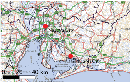
Fig. 1. Location of FY2025 Aichi Prefecture joint response rescue drill using ICT (created by the authors by adding location data to GSI tiles).
2.2. FY2025 Emergency Fire Response Team Chubu Block Joint Drill
The basic information for this drill is presented in Table 3, and the primary locations are indicated in Fig. 2. Logistical support activity training (activity coordination meetings), the camping areas for Gifu Prefecture, fire services, and other related agencies such as the Self-Defense Forces and police are geographically separated. Therefore, examining a framework for smooth information sharing and activity coordination is necessary. Although fire services can share a certain amount of information through the DJS, this system is not designed for information sharing with other agencies. Since April 2024, the Cabinet Office has been operating a SOBO-WEB as a means for ministries and local governments to collect and consolidate disaster information. Integration between the DJS and SOBO-WEB was scheduled for completion by the end of FY2024. Therefore, this drill aims to verify whether the combined use of SOBO-WEB and DJS contributes to smooth information sharing and coordination, including with non-fire agencies. Regarding information from other agencies such as the Self-Defense Forces and police, we aim to centralize data into SOBO-WEB by using SIP4D-Xedge, which is currently under research and development in a sub-theme C of the SIP 3rd Phase. Specifically, the drill focused on the acquisition of passage record information.
| Item | Description |
| Date and time |
Tabletop exercise: November 15, 2025, 8:00–12:00 Field Exercise: November 15, 2025 (PM) and November 16, 2025, 9:00–12:30 |
| Locations |
Tabletop exercise: Gifu Prefectural Government, Takayama City Fire Station (Ono Branch), Gifu Prefectural Disaster Prevention Aviation Center Field exercise (Nov. 15): Mino Saiseki (Takayama Office), Oshikiji Tunnel, Lake Araragi Field exercise (Nov. 16): Takayama City Kuraiyama Exchange Square (Montdeus Park), Mino Saiseki (Takayama Office) |
| Participating agencies | FDMA, Gifu Prefecture, Emergency Fire Response Teams (from 6 Chubu prefectures and Nagano Prefecture), Municipal fire departments in Gifu (Prefectural Mutual Support Teams), JGSDF, Gifu Prefectural Police, Takayama City Fire Corps, Gifu DMAT (Kumiai Kosei Hospital, Takayama Red Cross Hospital), Mino Saiseki Kogyo Co., Ltd., Takayama Sankyo Disaster Prevention Council, Gifu Ready-mixed Concrete Industrial Association, Search and Rescue Dogs (HDS K9) |
| Scenario | Following continuous rainfall in the Hida region since the night of November 12, an earthquake with an epicenter in the Takayama Ohara fault zone occurs between 7:30 and 10:00 on November 15. A maximum seismic intensity of 6-Upper is observed in Takayama City, with intensity 5-Upper or higher observed extensively in other areas. |
| Exercise items |
Nov. 15: Establishment and operation of headquarters; unit operational training (road clearance, vehicle rescue, landslide/sediment disaster rescue, isolated area rescue, unit deployment via aircraft); logistical support and camping training. Nov. 16: Unit operational training (mid-to-high-rise and collapsed/buckled building rescue, train accident response, collapsed wooden house rescue, forest fire and mountain rescue including aerial firefighting, landslide/sediment disaster rescue). |
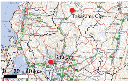
Fig. 2. Location of FY2025 Aichi Prefecture joint response rescue drill using ICT (created by the authors by adding location data to GSI tiles).
3. Results of the Empirical Experiments
3.1. FY2025 Aichi Prefecture Joint Response Agency Rescue Drill Using ICT
3.1.1. Activity Coordination in Activity Coordination Meetings and Other Agencies
Activity coordination was conducted in activity coordination meetings and field joint coordination centers were divided into three stages: prefecture, city, and field. The results of observing the discussion status in each meeting body are reported.
At the prefectural-level activity coordination meeting, the proceedings were advanced through the call and facilitation of the Aichi Prefectural Disaster Response Headquarters / Search and Rescue PT (Fig. 3). To advance into the disaster area, the dispatch of information collection units and other matters were decided. The process progressed as follows.
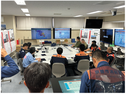
Fig. 3. Prefectural-level activity coordination meeting at the Aichi Disaster Headquarters.
First, the Aichi Prefecture requested a status report from each response agency regarding the current situation. Each response agency reports on the status of its activities and resources. Aichi Prefecture used SIP4D-Xedge (note: a geographic information system for disaster response for local governments and response agencies under development by NIED; currently renamed as Open-Xedge) and SOBO-WEB to share information on persons requiring rescue for each municipality in the prefecture and the status of impact incidents in Nishio City and Okazaki City. Furthermore, based on the human damage estimation information, rescue/search activity completion rate information (Fig. 4), and SNS information for each municipality in the prefecture, three cities and towns where the accurate damage situation was not determined were identified.
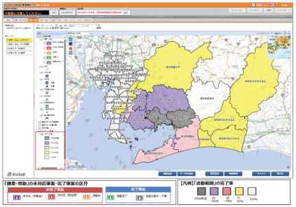
Fig. 4. Aggregate of rescue and search operation completion rates by municipality (SIP4D-Xedge).
Based on the above information analysis, Aichi Prefecture requested the dispatch of information collection units to these three relevant cities and towns as follows:
-
・
Gamagori City Hall: JGSDF, Chubu Regional Development Bureau
-
・
Kota Town Hall: Nagoya City Fire Bureau
-
・
Toyokawa City Hall: Aichi Prefectural Police Headquarters
At this time, regarding access routes during advancement, it was necessary to confirm road restriction information on SIP4D-Xedge and share the weather outlook for Aichi Prefecture from the (virtual) Nagoya Local Meteorological Observatory to confirm operational suspension criteria at the site. The Nagoya City Fire Bureau reconfirmed that the dispatch was strictly for the purpose of information collection and that the judgment to start activities would be made separately.
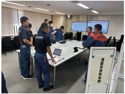
Fig. 5. Municipal-level activity coordination meeting at the Gamagori City Management Division.
At the city-level activity coordination meeting, proceedings were advanced by the call and facilitation of the Gamagori City Crisis Management Division and progressed as follows (Fig. 5).
Initially, Gamagori City reported on the damage situation in the city and the outline of impact incidents and requested a status report from each response agency. Each response agency reported the current status of the activities, resources, and arrival schedule of reinforcement units. Next, to finalize the division of activity areas for the three impact incidents, detailed information was shared again by Gamagori City. Regarding the constraints of access routes, information was shared based on the SIP4D-Xedge screen. In response to hot spring resort areas, the Japan Coast Guard proposed a policy to transport stranded guests by sea. For the collapsed building incident in Minamichigara, the police and Self-Defense Forces were decided to be deployed because a full-scale search and rescue operation by “roller operation” (thorough search) was necessary, but fire agencies had difficulty dispatching owing to fire response. Furthermore, for the fire incident in Myougara, the Gamagori City Fire Department and prefectural reinforcement teams have been already responding, as well as the Emergency Fire Response Teams currently advancing were decided to be deployed. The Kyoto City Fire Bureau reconfirmed that the dispatch of Emergency Fire Response Teams was necessary for small-scale fire in the hot spring resort area. In addition, the weather outlook for Aichi Prefecture was shared, and Gamagori City communicated that the operational suspension criteria would be discussed again based on future heavy rain situation. After this meeting, it was decided that only fire agencies would conduct coordination meeting regarding the detailed activity area division.
The Field Joint Coordination Center was advanced by the facilitation of the Gamagori City Fire Department after the call of the controller, the Gamagori City Fire Corps (Fig. 6). The process progressed as follows.
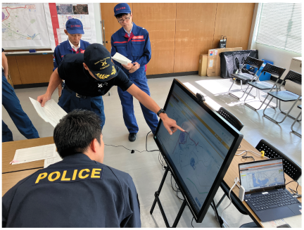
Fig. 6. Field Joint Coordination Center.
At the beginning, the Gamagori City Fire Corps shared information about the damage situation, number of households, road damage information, and the Nagoya City Fire Bureau raised the confirmation of the planned reinforcement scale of the prefectural reinforcement teams active in Nishio City, and it was confirmed that approximately 20 units were scheduled to arrive. The Gamagori City Fire Department proposed dividing the activity areas by roads and having Fire Corps members familiar with the local situation accompanying the units. Moreover, the hill where a shrine is located was proposed as an emergency evacuation site in the event of an aftershock or tsunami. In addition, at the time of operational suspension, it was confirmed that the standards of the Emergency Fire Response Teams would be followed, and communication by whistles would be used if an aftershock or tsunami occurred. Information was shared about areas accessible by vehicles and places where searching on foot was necessary, and it was discussed that the deployment of JGSDF heavy machinery was necessary for debris removal. However, because the prefectural fire reinforcement teams only had small amounts of heavy machinery, communication methods for cooperation with the Self-Defense Forces were discussed. Next, the availability of ambulances from the prefectural reinforcement teams was confirmed, and information was shared regarding the dispatch request status of Disaster Medical Assistance Team (DMAT). The tsunami risk in the area was established from Gamagori City, and drone flights were proposed by the Chubu Regional Development Bureau to confirm safe advancement routes. The results of the activity area division were registered as data in SIP4D-Xedge.
In addition, because the arrival of police units was delayed, the Gamagori City Fire Department conducted coordination regarding the activity areas of the police units, and the command policy was confirmed by the Nagoya City Fire Bureau. Finally, discussions were held by Gamagori City in response to inquiries from residents, sharing information on the status of shelters at nearby elementary and junior high schools, and arranging temporary emergency toilets.
After the major agenda items were completed, the police units arrived, and information was shared using SIP4D-Xedge regarding the field situation and division of activity areas (Fig. 7). Information sharing regarding the dispatch scale and base information was conducted from the Aichi Prefectural Police Headquarters, and the responses upon finding injured persons and the policy for unit rotation according to the area characteristics were confirmed.
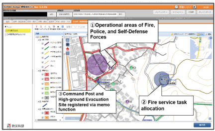
Fig. 7. Activity hazard information registration function and memo function (SIP4D-Xedge).
| Item | Description |
| Date and time | October 17, 2025, 9:10–11:42 |
| Locations | Within Aichi Prefecture (final destination: Gamagori City Gymnasium) |
| Participating agencies | Nagoya City Fire Bureau (prefectural reinforcement team): 3 personnel, Aichi Prefectural Police Headquarters: 4 personnel (2 units), JGSDF 10th Division: 2 personnel, Chubu Regional Development Bureau: 2 personnel |
| Scenario |
Following the results of the activity coordination meeting at the Aichi Prefectural Government, units were dispatched as follows:
Since reinforcement units were determined unnecessary for areas other than Gamagori City, the scenario assumed that all units would ultimately converge at the Gamagori City Gymnasium. |
| Exercise items | SIP4D-Xedge (including KKS-SYS and GNSS logger applications) |
3.1.2. Confirmation and Information Sharing of Road Condition
In this empirical experiment, an advancement drill (Table 4) was conducted using the Training Route Obstacle Notification System (KKS-SYS, Fig. 8), a function of SIP4D-Xedge, which notifies route obstacles when entering a pre-set virtual damage range based on the location information of the terminal. This function can be operated by the drill controller pre-registering an arbitrary virtual damage range as a polygon on the SIP4D-Xedge. The results of the advancement drill are as follows.
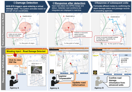
Fig. 8. Concept of the drill using KKS-SYS.
A delay occurred in the transmission of location information data from each terminal, causing a time lag in the location information and passage records (Fig. 9). Consequently, KKS-SYS entered a state where it did not operate even when entering the pre-set alert range. Therefore, the drill proceeded by switching to a policy of providing status updates via telephone for the information scheduled to be communicated via “status grant cards” to players who arrived at each city, town, or village office. Regarding the information delay status, the difference could be detected because of the location information from the Mobile Satellite Communication Equipment (Car-SAT) of Chubu Regional Development Bureau was shared in real-time with the prefectural government (Fig. 10).
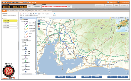
Fig. 9. Trajectory information at 10:00 on the day of the exercise on SIP4D-Xedge.
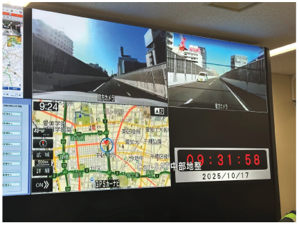
Fig. 10. Car-SAT information sharing session.
3.1.3. Questionnaire Survey
Following the completion of the drill, a structured questionnaire survey was conducted among the participating agency personnel (\(N =24\) from 12 agencies, including municipal/prefectural fire departments, prefectural police, JGSDF, Japan Coast Guard, and local governments) to quantitatively evaluate the coordination efficacy and extract the operational requirements. The survey items are listed in Table 5.
Regarding information sufficiency (Q6), 15 of the 23 valid respondents (65.2%, with 1 non-response among the total \(N =24\)) reported that shared information was sufficient for activity coordination. However, qualitative feedback (Q7) identified critical gaps in tactical parameters, such as exact unit scales, incoming personnel numbers, infrastructure statuses (power outages and water supply), and coordination items for aviation operations. Although no unnecessary data were reported in Q8, multiple agencies noted that specific resource capabilities (e.g., heavy machinery availability) were insufficiently defined in the initial scenarios.
The degree of coordination achievement (Q9) was quantitatively evaluated on a 5-point Likert scale (\(1=\) not achieved to \(5=\) fully achieved). As demonstrated in the distribution, Score 5: 2 respondents (8.3%), Score 4: 16 (66.7%), Score 3: 5 (20.8%), Score 2: 1 (4.2%), Score 1: 0 (0.0%), a total of 75.0% (18 out of 24) provided positive evaluations, with a mean score of 3.79 (SD \(=0.66\)). Regarding the qualitative reasons for achievement (Q10), participants stated that the common ICT platform enabled a cross-organizational “bird’s-eye view” of operating units, facilitated smooth area partitioning, and prevented discrepancies in situational awareness. Conversely, reflective opinions noted that coordination regarding rescue priorities, handling procedures for discovering victims, and on-site secondary disaster prevention measures have not been sufficiently executed.
| Item | Description |
| Survey period | October 17–October 31, 2025 |
| Targets | 12 participating agencies (Gamagori City Fire Department, Nagoya City Fire Bureau, Kyoto City Fire Bureau, Aichi Prefectural Police Headquarters, JGSDF 10th Division, 4th Regional Coast Guard Headquarters, Chubu Regional Development Bureau, Gamagori City, and Aichi Prefecture) |
| Number of responses | 24 responses from 12 agencies |
| Methodology | Combination of web-based responses via Microsoft Forms and paper-based responses |
| Survey items |
[Basic information]
[Drill scenarios and control matters]
[Activity coordination with other agencies]
[ICT used in the drill]
[General summary]
|
In the qualitative evaluation of ICT effectiveness (Q11), the operational advantages over conventional methods were positively evaluated by participants: (1) real-time visibility of road conditions, disaster distribution, and unit advancement fostered a shared operational picture and reduced the need for paper maps, and (2) multi-layered spatial data (maps, photographs) facilitated instantaneous situational understanding.
Operational and technical challenges were identified in Q12 and Q13. Key improvement points included: (a) difficulties in identifying incident markers on the map, (b) inferior map operability compared with commercial navigation applications (e.g., Google Maps), (c) lack of familiarity with operating mobile terminals (iPads), and (d) the need for intuitive visual indicators representing unit scales and specialized equipment. Furthermore, in the general summary (Q14 and Q15), the participants requested automated response suggestions using AI and direct data integration with traffic control centers.
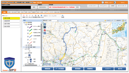
Fig. 11. Trajectory information from Gifu Prefectural Office to Lake Araragi on SIP4D-Xedge.
3.2. FY2025 Emergency Fire Response Team Chubu Block Joint Drill
In this drill, we conducted a verification of the acquisition, sharing, and utility of passage record information linked with SIP4D-Xedge, SOBO-WEB, and the FDMA’s DJS. Terminals that could connect to SIP4D-Xedge were provided to the Self-Defense Forces and police, and the input of response status and sharing of passage records from each base to the assembly location were performed. In addition, a layer group capable of displaying information from SIP4D-Xedge and DJS was prepared in SOBO-WEB to centralize the information. First, the passage records provided to the Self-Defense Forces were successfully acquired (Fig. 11). However, the passage records of police units could not be acquired because of communication interruptions when passing through tunnels. The acquired passage records were manually transferred to SOBO-WEB and displayed. By displaying these pieces of information along with DJS information in the “Common Operational Picture (COP): Response Agency Activity Coordination” layer of SOBO-WEB, we succeeded in centralized mapping. We asked the participating agencies to view these screens and collected opinions on whether they contributed to activity coordination. Consequently, there were opinions such as the following: on the SOBO-WEB screen, details can be displayed by clicking and selecting features that have better visibility than the DJS. In contrast, DJS has intuitive icons, allowing one to infer information attributes instantaneously; however, SOBO-WEB cannot immediately distinguish information attributes from icons. From these, challenges regarding the display method when displayed centrally were identified.
4. Discussion
Based on observations and feedback from the two empirical experiments, we categorized the identified challenges into “Rules for Information Sharing and Coordination,” “ICT Functionality and Operation,” and “Training and Proficiency,” each of which is discussed below.
4.1. Rules for Information Sharing and Coordination
In the field, a lack of precise parameters regarding deployed unit scales, personnel counts, equipment types, and critical infrastructure statuses (e.g., power outages and water supply availability) directly leads to resource misallocation and informational shortages during operations. Furthermore, operational requirements vary across organizations: the fire services prioritize structural damage and firefighting water supply, police focus on road networks and perimeter security, and Self-Defense Forces require clearance constraints and heavy-machinery load capacities. When these specific parameters and pre-defined responsibilities for triage and patient transport protocols are missing, coordination procedures remain vague, leaving field commanders unable to establish rescue priorities. Consequently, effective multi-agency coordination cannot be achieved when specific adjustment items are ambiguous, underscoring the need to establish standardized rules that define the required data items according to the operational phase and agency characteristics.
4.2. ICT Functionality and Operation
The empirical drills clearly highlighted how technical system designs must strictly align with frontline constraints.
1. Coping with Data Heterogeneity and Symbology
The layer-overlay architecture of SIP4D-Xedge and SOBO-WEB proved effective in allowing heterogeneous agencies to maintain situational awareness without altering their internal workflows. However, as observed in the Chubu drill, differences in UI representation, such as DJS’s intuitive tactical icons versus SOBO-WEB’s feature-selection menus, affected instantaneous cognition. A standardized symbology that bridges diverse agency cultures is essential.
2. Mitigating Communication Blackouts
The failure to record police vehicle trajectories during tunnel passage in the Chubu drill revealed a critical technical limitation. Frontline ICT tools cannot provide uninterrupted cellular connectivity. A robust store-and-forward (bucket-relay) caching mechanism is indispensable to ensure that route trajectories and incident logs acquired offline are automatically synchronized once connectivity is restored.
3. Real-Time Inter-Tier Feedback
A technical bridge is required to reflect decisions made at prefectural and municipal coordination meetings directly to the Field Joint Coordination Center in real-time, eliminating the latency and errors inherent in conventional telephone and oral communication. Furthermore, current systems require enhanced features to intuitively display advancing unit scale and heavy equipment availability on a map.
4.3. Training and Proficiency
Despite providing explanations before the drill, difficulties in operating the equipment occurred, indicating the need for a more comprehensive pre-training. Although response agencies have already possessed systems for use during disasters, these are rarely used in daily operations, leading to concerns about their usability during an actual crisis. The ICT solutions employed in this study must be integrated into routine operations and should feature intuitive user interfaces to ensure readiness.
4.4. Summary
Based on the above, the “Guidelines for Cooperation Among Related Agencies in Rescue and Search Activities During Large-Scale Disasters” issued by the FDMA require the collection, consolidation, and organization of as much disaster information as possible. However, during large-scale disasters, comprehensive information gathering is difficult when saving lives is prioritized. The two empirical experiments conducted in this study focused on how ICT tools can be employed for information sharing during this acute phase, specifically emphasizing the information that should be prioritized for collection and sharing.
Notably, this study addresses the fundamental challenge of response agencies being inherently structured as self-contained organizations that have historically hindered inter-agency ICT integration. By evaluating a three-tiered coordination framework across the prefectural, municipal, and field levels, we demonstrated that cross-organizational activity coordination can be effectively supported when ICT systems are specifically tailored to the operational granularity of each tier. The empirical findings provide concrete system design requirements, that is, layer-based data federation, offline synchronization, and intuitive cross-agency symbology, necessary to realize an actionable COP in acute disaster response.
5. Conclusions
This study focused on activity coordination during the acute initial response phase, when field response agencies address the common objective of saving lives. To address the structural challenge, that is, the “negative legacy” that response agencies were designed as self-contained organizations with scarce opportunities for joint multi-agency drills, we structurally incorporated a three-tiered joint coordination framework (prefectural, municipal, and field levels). We conducted two empirical experiments to evaluate the functionality of ICT-based information systems for efficient and effective operations, as well as the sharing and use of essential vehicle passage records for entering disaster-stricken areas, followed by a questionnaire survey of the participating agencies. Based on these efforts, critical challenges were extracted regarding the promotion of sharing damage and passage information, as well as the development of common platforms.
By observing inter-agency dialogues during activity coordination meetings, we analyzed the perspectives and workflows through which operational policies were adjusted. Combined with the survey findings, we identified the key parameters indispensable for effective coordination, including the deployed unit scales, capabilities, and real-time infrastructure statuses.
The findings emphasize that the successful integration of ICT into disaster response depends not only on system capabilities but also on establishing standardized coordination protocols and embedding these tools into routine daily operations to ensure operational proficiency. Overcoming the identified technical and operational challenges is crucial for establishing a robust COP, ultimately contributing to realizing more effective and synchronized life-saving operations during catastrophic disasters.
Acknowledgments
The authors express their sincere gratitude to the personnel of the participating agencies for their cooperation with the empirical experiments and questionnaire surveys conducted in this study. This research was supported by the Council for Science, Technology and Innovation (CSTI), Cross-ministerial Strategic Innovation Promotion Program (SIP), “Development of a Resilient Smart Network System against Natural Disasters” Grant Number JPJ012289 (funding agency: NIED).
- [1] Fire and Disaster Management Agency (FDMA), Ministry of Internal Affairs and Communications, “Operational guidelines for inter-agency cooperation in search and rescue activities during catastrophic disasters,” (in Japanese). https://www.fdma.go.jp/mission/prepare/cooperation/post.html [Accessed March 20, 2026]
- [2] Wide Area Support Office, Fire and Disaster Management Agency (FDMA), Ministry of Internal Affairs and Communications, “Information on emergency fire response teams,” 2025 (in Japanese). https://www.fdma.go.jp/publication/ugoki/items/rei_0706_24.pdf [Accessed August 22, 2026]
- [3] National Police Agency, “Notice on the organization, operation, etc. of the police disaster dispatch unit,” NPA Heibi-3 No.26 etc., 2024 (in Japanese). https://www.npa.go.jp/laws/notification/keibi/keibi3/keibi3_20240829_2.pdf [Accessed August 22, 2026]
- [4] Ministry of Defense and Self-Defense Forces, “Disaster relief operations,” (in Japanese). https://www.mod.go.jp/j/approach/defense/saigai/index.html [Accessed August 22, 2026]
- [5] K. Kato, “Inter-organizational co-operation in natural disasters: NPA, FDMA, JSDF and JCG’s domain and co-operation in EOC,” Studies in Humanities and Social Sciences (Social Sciences Series), Vol.102, pp. 47-94, 2011 (in Japanese).
- [6] T. Nakazawa, “Addressing natural disasters with the capabilities of the SDF: Achieving seamless responses by the relevant organizations,” NIDS J. of Defense and Security, Vol.18, No.1, pp. 75-108, 2015 (in Japanese).
- [7] E. Wang, D. Zheng, and X. Li, “Cross-organizational information sharing and coordination in disaster response: The case of the 2008 Wenchuan China Earthquake,” J. Disaster Res., Vol.10, No.2, pp. 363-372, 2015. https://doi.org/10.20965/jdr.2015.p0363
- [8] K. Saito and M. Umemoto, “Comparison of standardized incident management systems in developed countries and consideration of the feasibility of introducing these systems in Japan,” J. of Social Safety Science, Vol.44, pp. 25-35, 2024 (in Japanese). https://doi.org/10.11314/jisss.44.25
- [9] Y. Okita, “Standardisation of the coordination mechanism for international USAR teams: Examples from the INSARAG marking and assessment forms,” J. of Social Safety Science, Vol.26, pp. 1-10, 2015 (in Japanese). https://doi.org/10.11314/jisss.26.1
- [10] Y. Okita and T. Katsube, “Coordination of international urban search and rescue (USAR) teams in the 2015 Nepal Earthquake: ‘Disaster literacy’ for international USAR,” J. of Japan Association for Earthquake Engineering, Vol.15, No.6, pp. 6_112-6_125, 2015 (in Japanese). https://doi.org/10.5610/jaee.15.6_112
- [11] M. Iida, H. Kudo, K. Tsutsui, T. Isono, S. Sato, A. Furukawa, and T. Ise, “Survey and consideration of the actual situation of activity coordination meetings among field response agencies: Case studies of the 2024 Noto Peninsula Earthquake and the 2024 Oku-Noto Heavy Rains,” J. of Natural Disaster Science, Vol.44, No.S12, pp. 81-93, 2025 (in Japanese). https://doi.org/10.24762/jndsj.44.S12_81
- [12] Y. Hada, N. Kodama, T. Suzuki, I. Suetomi, and K. Meguro, “A study on road information sharing using probe vehicle data in disasters,” Proc. of the JSCE Earthquake Engineering Symp., Vol.29, pp. 801-809, 2007 (in Japanese). https://doi.org/10.11532/proee2005a.29.801
- [13] N. Kodama, Y. Hada, T. Suzuki, and K. Meguro, “Numerical simulation of road information gathering and travel time saving in disaster by sharing probe vehicle data,” J. of Disaster Information Studies, Vol.6, pp. 89-94, 2008 (in Japanese). https://doi.org/10.24709/jasdis.6.0_89
- [14] Y. Hada, T. Suzuki, H. Shimora, K. Meguro, and N. Kodama, “Issues and future prospect on practical use of probe vehicle data for disaster reduction—Provision of the vehicle tracking map in the 2007 Niigataken Chuetsu-oki Earthquake—,” J. of Japan Association for Earthquake Engineering, Vol.9, No.2, pp. 2_148-2_159, 2009 (in Japanese). https://doi.org/10.5610/jaee.9.2_148
- [15] T. Mizutani, S. Itubo, D. Toriumi, and H. Makino, “Feasibility study of identifying passable routes after disasters made from ETC2.0 probe data,” 14th ITS Symp., 2016.
- [16] T. Ise, M. Iida, K. Yoshimori, H. Kudo, K. Tsutsui, and A. Furukawa, “Issues regarding information sharing of field response agencies in the 2024 Noto Peninsula Earthquake: Considerations regarding the role and limitations of the ISUT-SITE,” J. of Japan Society for Natural Disaster Science, Vol.43, No.3, pp. 427-435, 2024 (in Japanese). https://doi.org/10.24762/jndsj.43.3_427
This article is published under a Creative Commons Attribution-NoDerivatives 4.0 Internationa License.