
Review:
Artificial Island Development as a Climate Change Adaptation Measure for Atoll Countries: A Country-by-Country Review
Mikiyasu Nakayama†
 , Yuto Kunitake
, Emiri Iwasaki, and Sae Koyama
, Yuto Kunitake
, Emiri Iwasaki, and Sae Koyama
Global Infrastructure Fund Research Foundation Japan
Shiodome City Center 5F, 1-5-2 Higashi Shimbashi, Minato-ku, Tokyo 105-7105, Japan
†Corresponding author

Low-lying atoll countries face existential threats from climate change, including sea-level rise, freshwater contamination, and coastal erosion. This review examines artificial island development as a transformational adaptation strategy for four atoll countries (the Maldives, Kiribati, the Marshall Islands, and Tuvalu) through a comparative analysis evaluating technical, financial, legal, and governance dimensions. Our findings reveal that artificial island development is technically achievable, as demonstrated by the Maldives’ Hulhumalé project, which has created approximately 4 km2 of elevated land at twice the elevation of natural islands. However, implementation feasibility varies substantially across nations depending on governance structures and land-tenure systems. Centralized state ownership in the Maldives enables rapid implementation, while customary land tenure in Pacific nations presents significant barriers. Financial requirements vastly exceed domestic fiscal capacities, with estimated adaptation costs ranging from hundreds of millions to billions of U.S. dollars, necessitating substantial international climate finance. The review identifies critical environmental trade-offs, because dredging operations damage coral reef ecosystems, which provide natural coastal protection, and highlights unresolved legal uncertainties under the United Nations Convention on the Law of the Sea (UNCLOS) regarding maritime zones and sovereignty preservation. Despite these challenges, artificial islands offer a pathway to honor atoll communities’ “right to stay” in their homelands, although successful implementation requires integrated governance reform, sustained international financing, and environmental safeguards in addition to engineering solutions.
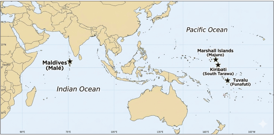
The four atoll countries reviewed
1. Introduction
Artificial island development is increasingly being discussed as a transformational climate change adaptation strategy for atoll countries facing land loss, freshwater contamination, and declining habitability. However, the technical, financial, legal, and social feasibility of such measures varies widely across national contexts. Therefore, this review evaluates the following:
-
The engineering and economic viability of constructing climate-resilient artificial islands (Sections 1.2.3 and 1.2.6).
-
The legal and governance frameworks that shape their implementation (Sections 1.2.5 and 1.3.3).
-
The environmental and societal trade-offs inherent in this form of adaptation (Sections 1.2.4 and 1.2.7).
This section argues that the feasibility of artificial islands for atoll countries depends on integrated assessments of engineering, legal, financial, and socioecological factors, forming the evaluative framework for country-specific analyses in Sections 2–5.
This section establishes the analytical foundation for this study.
It consolidates the conceptual, environmental, legal, and socioeconomic background necessary to understand why artificial islands have emerged as a policy option and how they should be evaluated in comparison with conventional adaptation measures. The section proceeds in three steps.
First, Section 1.1 outlines the vulnerability of atoll countries to climate change, focusing on physical and socioeconomic risk factors. This section provides the baseline context—geomorphology, climate projections, population pressures, and sovereignty concerns—that shape adaptation planning in low-lying island states.
Second, Section 1.2 introduces the conceptual and practical foundations of artificial island development as a transformational adaptation strategy. It explains why the limitations of conventional adaptation tools have led some atoll governments to consider engineered land creation and presents a structured framework for evaluating artificial island feasibility: problem definition, design concepts, engineering requirements, environmental implications, legal status, financing mechanisms, and comparison with alternative adaptation pathways.
Finally, Section 1.3 provides an overview of the four case study countries—the Maldives, Kiribati, the Marshall Islands, and Tuvalu. It outlines their geographic and socioeconomic profiles, governance and land-tenure systems, as well as their varying trajectories in considering or implementing artificial island initiatives. This section positions the comparative case studies that follow in Sections 2–5.
Overall, this section clarifies why artificial island development has become a salient policy question for atoll countries and sets out the evaluative criteria that the remainder of the review applies in a country-by-country analysis.
1.1. Climate Change and Atoll Countries
Atoll countries such as Kiribati, Tuvalu, the Marshall Islands, and the Maldives face an unparalleled degree of climate vulnerability due to the interaction of their geomorphological characteristics, regional climate trends, and socioeconomic constraints. These factors jointly undermine long-term habitability and frame the adaptation challenges examined in this study.
1.1.1. Geomorphological Vulnerability of Atoll Systems
Figure 1 shows the geographical locations of the four atoll countries examined in this study. Atolls are low-lying carbonate islands that rarely exceed 2–3 m in elevation above mean sea level 1. This extremely low topography renders them highly susceptible to even modest increases in sea level. Their porous substrates allow seawater to infiltrate readily, placing the thin freshwater lenses—often their primary source of potable water—under constant threat from salinization and storm-driven overwash 2,3. The physical stability of atoll islands is inseparable from the health of their surrounding coral reefs, which dissipate up to 97% of incoming wave energy and supply the carbonate sediment essential for island maintenance 4. As ocean warming and acidification impair corals’ capacity to survive and accrete, these islands simultaneously lose natural wave protection and sediment supply 5. This convergence of factors places atoll systems among the most geomorphologically fragile environments on Earth.
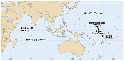
Fig. 1. Locations of the four atoll countries examined in this review.
1.1.2. Climate Change Projections and Compound Risks
Sea-level rise (SLR) is the most direct existential threat, with global mean sea level projected to rise by 0.28–0.55 m under the low-emission SSP1-2.6 scenario and 0.63–1.01 m under the high-emission SSP5-8.5 scenario by 2100 6. Regional SLR in the Pacific and Indian Oceans is expected to exceed the global mean 7, further intensifying exposure. However, scientific evidence indicates that atolls may become effectively uninhabitable well before they are permanently submerged. Wave-driven flooding is projected to contaminate freshwater resources by mid-century, rendering many islands uninhabitable decades before complete inundation 1. These trends are unfolding alongside escalating ocean warming that has driven mass coral bleaching events, including the 2014–2017 episode, which affected more than 75% of global reef systems 8. Ocean acidification further constrains coral growth and compromises reef structural integrity 9. Climate projections also indicate greater rainfall variability, including more prolonged droughts and episodes of intense precipitation, whereas the frequency of the most severe tropical cyclones is expected to increase, even if total cyclone numbers do not 10,11. Collectively, these interacting processes are accelerating the decline of habitability under moderate- and high-emission futures.
1.1.3. Socioeconomic Dimensions of Vulnerability
The physical risks faced by atoll countries are compounded by demographic pressures and economic structures that heighten exposure and restrict adaptive capacity. Population densities in capital atolls such as South Tarawa, Kiribati, exceed 3,000 persons/km\(^2\) 12, while Malé houses over 40% of the Maldives’ population on only 8.3 km\(^2\) 13. These extreme densities place immense stress on land, water, and infrastructure systems that are already situated at extremely low elevations. Economic dependence on climate-sensitive sectors intensifies vulnerability: projected declines in tuna stocks of up to 20% within some exclusive economic zones (EEZs) threaten key revenue streams in Pacific atoll countries 14. Moreover, the degradation of coral reefs jeopardizes tourism in the Maldives, where the sector contributes nearly 30% of gross domestic product (GDP) 15. Critical national infrastructure—including airports, ports, and hospitals—is typically only 1–2 m above sea level, exposing essential services to the combined effects of chronic flooding and extreme events 16. Institutional and financial constraints further limit the ability of many atoll governments to pursue large-scale adaptation measures, narrowing available pathways for climate resilience 17.
1.1.4. Existential Threats to Territorial Integrity and Statehood
Beyond environmental and economic pressures, climate change challenges the foundational criteria of statehood. Under the Montevideo Convention, a state requires a permanent population, a defined territory, and an effective government 18. The progressive loss of habitable land raises unprecedented questions regarding whether atoll countries can maintain these attributes as flooding, erosion, and salinization intensify. Maritime zones established under the United Nations Convention on the Law of the Sea (UNCLOS) are measured from coastal baselines that may shift or disappear as sea levels rise 19. The potential reduction or loss of exclusive economic zones has profound implications for resource access and geopolitical standing. Although international law has not resolved whether statehood can persist without habitable territory, scholars have argued that climate-related displacement may force the reconsideration of existing norms 20. Nonetheless, political leaders in atoll countries have consistently rejected external migration as a viable solution, emphasizing sovereignty, cultural continuity, and the right to remain in ancestral homelands 21. These concerns underscore the profound legal and existential dimensions of climate change for atoll countries and highlight why understanding their vulnerability is essential for evaluating adaptation choices.
1.1.5. International Recognition of Climate-Related Migration and Cross-Border Movement
Growing recognition that climate change poses displacement risks for populations of low-lying states has prompted a series of international legal and policy developments. The 2018 Global Compact for Safe, Orderly and Regular Migration (GCM), adopted by the United Nations General Assembly, marks the first time that climate change, environmental degradation, and natural disasters have been acknowledged as drivers of migration in a comprehensive international framework 22. While not legally binding, the GCM establishes principles for addressing climate-related cross-border movement, including commitments to develop adaptation and resilience strategies that minimize the drivers of displacement.
More recently, the International Court of Justice (ICJ)’s 2025 Advisory Opinion on the obligations of States with respect to climate change has further clarified that climate change–induced impacts, including those threatening the habitability of low-lying States, engage state responsibilities under international law 23. This opinion reinforces the legal foundation for climate-affected countries to seek international support for adaptation measures, including those aimed at preserving territorial integrity.
These developments intersect with longstanding gaps in refugee and displacement law. The 1951 Convention Relating to the Status of Refugees does not include climate or environmental change among the grounds for refugee status, leaving climate-induced migrants without clear international legal protection 24. This gap has prompted calls for new frameworks that address climate displacement, including proposals for “climate passports” and the recognition of a “right to migrate” as a form of adaptation. Concurrently, bilateral arrangements have emerged as pragmatic responses: the 2023 Falepili Union Treaty between Tuvalu and Australia provides a migration pathway to Australia for approximately 280 Tuvaluan citizens per year while reinforcing Australia’s recognition of Tuvalu’s ongoing statehood and sovereignty 25. These contrasting approaches—multilateral normative frameworks, bilateral mobility agreements, and in situ adaptation through territorial preservation—define the policy landscape within which artificial island development must be evaluated.
1.2. Artificial Islands as a Transformational Adaptation Strategy
The growing recognition that conventional adaptation measures may be insufficient to preserve long-term habitability in atoll countries has prompted increasing interest in transformational approaches. The Intergovernmental Panel on Climate Change defines transformational adaptation as a fundamental alteration of social–ecological systems in response to climate impacts that exceed the limits of incremental strategies 26. In practice, transformational adaptation requires large-scale, irreversible changes beyond incremental coastal protections, including population-scale land creation and new governance for artificial territory. In atoll countries, where SLR, freshwater salinization, and coral reef degradation threaten the continued viability of natural islands, artificial island development has emerged as a potential means of creating elevated, climate-resilient territory capable of sustaining populations long term. This section describes the conceptual, technical, environmental, legal, and financial considerations that underpin this adaptation pathway and provides a structured framework for evaluating its feasibility.
1.2.1. Problem Definition and Conceptual Rationale
Conventional coastal protection measures—including seawalls, groynes, and revetments—have often yielded mixed or negative outcomes in atoll settings. Hard infrastructure frequently accelerates erosion on adjacent shorelines and disrupts the sediment transport processes essential to island stability 27. Soft measures such as beach nourishment require continual replenishment, and ecosystem-based approaches cannot fully compensate for the rapid climate-driven loss of coral reef functionality 28. Even land reclamation projects—such as the Maldives’ Hulhumalé development—increase available land but do so at elevations insufficient to keep pace with high-end SLR projections 29. Relocation, whether internal or external, confronts acute cultural, political, and sovereignty challenges. Atoll leaders have repeatedly affirmed that migration cannot serve as a primary adaptation strategy because of the inherent value of maintaining territorial continuity and national identity 21.
Collectively, these limitations demonstrate that many atoll countries confront adaptation thresholds beyond which incremental measures may no longer be viable. This reality has led to growing interest in transformational strategies such as artificial island construction, which creates durable, elevated landforms capable of withstanding projected climate hazards—including SLR and increased storm surges—well beyond the design horizons of traditional measures.
1.2.2. Conceptual Framework and Definition
Artificial islands, although variably defined in technical and legal literature, are generally understood as man-made landforms created through the placement of fill or the construction of fixed elevated structures. Unlike conventional reclamation projects, climate-resilient artificial islands are specifically engineered to maintain habitability under high-end SLR scenarios. They differ from natural islands in their legal status under the United Nations Convention on the Law of the Sea, as UNCLOS Article 60 states that artificial structures cannot generate territorial seas or exclusive economic zones 30. Artificial islands are typically categorized as hydraulic fill islands, fixed elevated platforms, or floating structures 31. Floating platforms remain largely experimental and face significant social and technical barriers in atoll contexts 32. This review focuses on land reclamation and fixed elevated structures, excluding floating platform concepts (e.g., Lister and Muk-Pavic 33). This approach aligns more closely with current governmental planning.
For atoll countries, artificial islands represent a transformational strategy because they seek to alter the physical foundations of habitation. Their design typically requires significantly greater elevation than natural islands and often incorporates self-contained infrastructure—such as water desalination, renewable energy systems, and advanced drainage networks—to ensure long-term resilience. These features distinguish artificial islands from the small-scale, incremental land extensions commonly found across atoll regions.
1.2.3. Engineering Approaches and Climate-Resilient Design Requirements
The construction of artificial islands in atoll environments involves a complex set of engineering challenges shaped by carbonate geology, limited sediment availability, and the need to ensure long-term climate resilience. Hydraulic fill methods—such as those employed in the Maldives’ Hulhumalé project—rely on trailing suction hopper dredgers that extract sediment from lagoons or offshore sources and deposit it onto submerged reef platforms 34. The choice between lagoon-based and offshore sediment sources reflects a trade-off between environmental impact and financial cost: lagoon dredging offers logistical advantages but can cause extensive damage to benthic habitats, whereas offshore extraction is more expensive.
Elevation standards are among the most critical design decisions. Hulhumalé was constructed approximately 2 m above mean sea level—double the elevation of Malé 35. Nevertheless, recent analyses suggest that elevations of 6 m or more may be required to maintain safety margins in high-emission scenarios by late century 36. The long-term stability of artificial islands depends on reinforced coastal defense, robust geotechnical foundations, and integrated urban planning approaches that incorporate natural ventilation, permeable surfaces, and stormwater management systems suitable for tropical atoll environments. These requirements illustrate the technical complexity of creating climate-proof landforms capable of supporting dense populations.
The significance of such projects has been recognized at the highest levels of international climate assessment. The Sixth Assessment Report of the Intergovernmental Panel on Climate Change—particularly Working Group II, Chapter 15, on “Small Islands”—identifies land reclamation and artificial islands, including Hulhumalé, as adaptation measures being pursued by small island developing states in response to climate change 28.
1.2.4. Environmental Implications and Mitigation Challenges
Artificial island construction poses significant environmental risks, particularly to coral reef ecosystems, which underpin natural island stability and marine biodiversity. Dredging operations physically remove benthic communities, whereas sediment plumes generated during construction can smother corals over wide areas 37. Studies have documented a rapid decline in the capacity of many Maldivian islands to naturally adjust to ocean conditions, with nearly half exhibiting substantial degradation in reef protective functions 38. The cumulative expansion of reclaimed land—estimated at roughly 2,500 ha in the Maldives since the 1970s—has contributed to the widespread reduction of ecosystem resilience 39.
Mitigation strategies such as timing restrictions during bleaching episodes, coral transplantation, sediment containment, and comprehensive environmental impact assessments (EIAs) can reduce but not eliminate these impacts. The core dilemma is that constructing artificial islands to safeguard human populations may simultaneously accelerate the degradation of the ecosystems that once provided natural protection. This trade-off remains one of the most contentious aspects of artificial island development.
1.2.5. International Legal Framework and Implications for Sovereignty
The legal status of artificial islands is shaped by UNCLOS, which specifies that artificial structures have no territorial sea, exclusive economic zone, or continental shelf of their own 30. This principle was reaffirmed in the 2016 South China Sea Arbitration, underscoring that artificial landforms cannot alter maritime boundaries. However, UNCLOS does not explicitly address whether land reclamation, in addition to submerged or submerging natural features, can maintain the legal status of the underlying territory. This ambiguity has implications for atoll countries that may seek to reinforce or elevate existing islands to preserve baselines and maritime claims.
Broader questions of statehood arise in parallel. As SLR encroaches on habitable land, the permanence of population, territory, and governance—criteria set forth under the Montevideo Convention 18—becomes increasingly uncertain. Some scholars argue that States should retain their legal personality even in the absence of habitable territory 20, whereas others emphasize the need for new international legal frameworks to address climate-induced territorial loss. These debates highlight the centrality of artificial islands in broader discussions on the sovereignty, territorial continuity, and rights of climate-affected populations. Appendix A provides a chronological overview of the key international legal instruments, scientific assessments, regional declarations, and bilateral agreements that collectively shape the policy and legal landscape for artificial island development in atoll countries.
1.2.6. Financing Mechanisms and Economic Viability
The financial feasibility of artificial island development is one of the most formidable obstacles for atoll countries. The capital costs of constructing large-scale, elevated landforms suitable for national populations commonly reach up to hundreds of billions of U.S. dollars. For countries such as Kiribati and Tuvalu, whose GDP per capita ranges from approximately U.S. dollars (USD) 2,000–5,400, the cost of even a single project may exceed their entire annual national income. This financial disparity renders external support indispensable.
However, access to climate finance remains limited. The Green Climate Fund (GCF) has approved only around USD 1.6 billion for all small island developing states (SIDS) combined, representing approximately 12% of its total portfolio, despite their extreme vulnerability 40. Moreover, approximately 44% of adaptation finance for SIDS is delivered as debt rather than as grants, raising concerns about long-term debt burdens that could undermine national sovereignty. Bilateral aid, public–private partnerships, and debt-for-climate swaps offer supplementary avenues but remain insufficient to close the financing gap. Analysts caution that large-scale artificial island projects create long-term dependencies on engineered systems, potentially locking nations into costly maintenance cycles that persist for decades 38,41.
1.2.7. Comparative Assessment with Alternative Strategies
Artificial islands must be evaluated within the broader landscape of adaptation strategies available to atoll countries. Hard protection offers short-term benefits but often induces ecological degradation or erosion elsewhere 27. Ecosystem-based approaches provide valuable co-benefits but cannot fully compensate for the acceleration of reef loss. Planned relocation faces institutional, social, and cultural barriers, particularly given the strong political commitment of atoll country leaders to remain in their homelands 21. For nations without high islands or extensive interior space, internal relocation is generally not feasible.
Against this backdrop, artificial islands have the distinctive advantage of preserving sovereign territory in situ, while enabling the creation of elevated, climate-resilient land. However, they entail severe environmental impacts, high financial barriers, technological dependencies, and significant disruption to existing sociocultural relationships with the marine environment. Thus, their viability depends on country-specific combinations of finance, governance capacity, legal certainty, environmental conditions, and public acceptance. These conditions vary widely across atoll countries and form the basis for the comparative analysis in subsequent sections.
Sections 1.1–1.3 provide the integrated evaluative framework—spanning environmental vulnerabilities, conceptual foundations, legal-financial constraints, and country contexts—that Sections 2–5 apply in country-specific assessments.
1.3. Overview of the Four Atoll Countries
Atoll countries exhibit shared vulnerabilities and significant differences in governance, economic capacity, and adaptation trajectories. This section provides essential comparative context for the Maldives, Kiribati, the Marshall Islands, and Tuvalu—the four countries examined in this review. Their common geomorphological characteristics place them at the forefront of climate-related risks. Nonetheless, their institutional structures and development pathways diverge in ways that shape the feasibility of artificial island development.
1.3.1. Rationale for Case Selection: Why These Four Atoll Countries?
Among the 38 SIDS, only a small subset is composed entirely of low-lying atolls without higher volcanic terrain. The Maldives, Kiribati, the Marshall Islands, and Tuvalu share this distinctive geomorphology, with maximum elevations rarely exceeding 3 m above mean sea level 42. As no interior upland areas are suitable for internal relocation, climate change directly threatens their territorial integrity and habitability in ways that differ fundamentally from island nations with high islands, such as Fiji and the Solomon Islands.
These four atoll states have also played a significant role in international diplomacy on climate change, coordinating through the Alliance of Small Island States (AOSIS) and, more recently, forming the Coalition of Atoll Nations on Climate Change (CANCC) in 2014 42,43,44. Their diplomatic efforts underscore shared concerns regarding SLR, climate mobility, and the continuity of statehood, along with highlighting the political salience of preserving sovereign territory. Simultaneously, these countries differ in their approaches to artificial island development: the Maldives has pursued extensive reclamation for decades; Kiribati and Tuvalu are advancing planning frameworks; and the Marshall Islands is evaluating multiple adaptation pathways without committing to a single strategy 45. These contrasting approaches provide a valuable basis for comparative analysis.
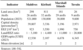
Table 1. Comparative profiles of the four atoll countries.
1.3.2. Comparative Geographic and Socioeconomic Profiles
These four countries differ markedly in terms of land area, population distribution, economic capacity, and maritime jurisdiction. Table 1 summarizes the key indicators relevant to their adaptation contexts.
These data reveal several structural patterns. The extreme imbalance between land area and exclusive economic zones, exemplified by Tuvalu’s land-to-EEZ ratio of \(1:\textrm{28,800}\) being one of the most disproportionate in the world, highlights the strategic importance of maritime jurisdiction for national livelihoods and sovereignty 19. Urban population densities in capital atolls are exceptionally high, with Malé exceeding 39,807 persons per square kilometer, generating intense pressure on limited land resources and motivating reclamation efforts, independent of future climate projections 55. Economic disparities are also pronounced: the Maldives’ GDP per capita is nearly an order of magnitude higher than that of Kiribati, and the Pacific states rely heavily on fishery royalties, remittances, and external assistance 56. Collectively, these factors shape each country’s capacity to finance, govern, and maintain large-scale adaptation infrastructure such as artificial islands.
1.3.3. Governance Structures and Land-Tenure Systems
Governance and land-tenure systems play a critical role in determining the feasibility of artificial island development. The Maldives operates under a highly centralized system in which the state retains ownership of most land 57. This arrangement allows the government to undertake extensive reclamation projects without the complex negotiations required in customary tenure contexts; it has also facilitated the accumulation of technical expertise across decades 29.
Conversely, Pacific atoll countries maintain customary land-tenure systems in which land ownership is vested in extended families or lineage-based groups. In Kiribati, most of the land in South Tarawa is held under customary arrangements that require negotiation and consent for any significant land-use change 58. The Marshall Islands adds further complexity through its hierarchical Iroij–Alap–Ri-jerbal system; the historical displacement associated with nuclear testing has created additional sensitivities surrounding land rights and community relocation 59,60. In Tuvalu, traditional assemblies known as Falekaupule exert substantial influence over local development decisions, in accordance with the Falekaupule Act 61. These customary systems safeguard community interests but complicate efforts to define the ownership of newly reclaimed land, as customary legal frameworks rarely address the status of land created from the sea. These institutional differences shape artificial island feasibility: the Maldives’ state ownership enables centralized implementation, whereas Pacific nations’ customary systems require complex negotiations over rights to newly created land.
1.3.4. Divergent Adaptation Trajectories
Although the four atoll countries face similar biophysical risks, their adaptation trajectories differ significantly. The Maldives is the only country to have completed large-scale artificial island development. Hulhumalé, initiated in 1997, has produced a 4.32 km\(^2\) island with an elevation of approximately 2 m above mean sea level and a planned capacity exceeding 240,000 residents 62. This outcome reflects a combination of centralized land ownership, sustained political support, tourism-generated revenue, and accumulated technical capacity 63.
Kiribati and Tuvalu are at the planning stage. Kiribati’s Temaiku reclamation proposal for South Tarawa has undergone feasibility assessments but has not progressed due to financing and land-tenure complexities 64. Meanwhile, Tuvalu’s National Adaptation Plan (NAP), adopted in August 2025, positions land reclamation as a vital component of its climate resilience strategy 65. The NAP’s overarching framework—the National Reclamation and Relocation Strategy (Tuvalu Survival Pathway)—aims to develop and implement an integrated framework for reclamation, relocation, and coastal protection 65. This strategy is aligned with the Te Kete National Development Strategy 2021–2030, which mandates a phased land reclamation program designed to address the worst-case scenario of up to 1 m of SLR by 2100 65. Short-term actions (2025–2030) include continuing land reclamation in priority areas, such as Funafuti and Nukufetau, while medium-term plans (2030–2050) envision managed relocation and ecosystem-based adaptation 65. The 2023 Falepili Union Treaty with Australia provides mobility pathways for Tuvaluan citizens while reinforcing international recognition of Tuvalu’s ongoing statehood 25. However, both nations face significant resource constraints that limit near-term implementation.
The Marshall Islands remains in an exploratory phase, weighing options for coastal protection, island elevation, and community relocation 66. Its widely dispersed population and historical legacy of nuclear testing make relocation and land-use planning particularly sensitive. Additionally, the migration provisions under the Compact of Free Association (COFA) with the United States complicate national debates by providing an established pathway for voluntary movement abroad 60.
These divergences demonstrate that the feasibility of artificial island development depends on environmental conditions, political preferences, economic capacity, and institutional structures. Understanding these country-specific trajectories is essential for evaluating the prospects of artificial islands as an adaptation strategy. Therefore, the subsequent sections undertake a detailed country-by-country analysis.
2. Maldives: Leading Innovation in Artificial Island Development
The Maldives has emerged as one of the most prominent cases of innovation in artificial island development under conditions of extreme climate vulnerability. Often portrayed as the world’s lowest-lying nation, the country has pursued artificial islands as engineering solutions to SLR and as integrated instruments of urban restructuring, population consolidation, and state-led climate adaptation. Innovation in the Maldivian context extends beyond reclamation technologies to encompass governance arrangements, financing mechanisms, and socio-environmental trade-offs. This section examines how artificial islands have been conceived, implemented, and contested in the Maldives by assessing their adaptive potential and the new forms of ecological, fiscal, and institutional risks they generate.
2.1. Country Profile and Climate Vulnerability
Often described as the world’s lowest-lying country, the Maldives has an average elevation of approximately 1.5 m above mean sea level and faces a substantial risk of submergence driven by SLR. The capital, Malé, is among the world’s most densely populated urban areas, with approximately 250,000 residents living on the central island of Malé (less than 6.8 km\(^2\)), and acute housing shortages and severe pressure on infrastructure constitute pressing challenges. Under these conditions, the Maldivian government has promoted the creation of new artificial islands with the dual aims of climate change adaptation and decentralization of urban functions 34,35,67,68.
Key motivations for artificial island development include: (1) securing residential land by creating higher-elevation terrain resilient to SLR, storm surges, and tsunamis 67; (2) alleviating congestion in the Greater Malé area and accommodating population growth 69; (3) strengthening the economic base by expanding tourism and industrial infrastructure 68; and (4) supporting island consolidation under the post-2004 Indian Ocean tsunami “Safer Island” policy by relocating residents from vulnerable small islands to larger disaster-preparedness hubs 70. Against this backdrop, the Maldives began large-scale land reclamation and artificial island construction in the late 1990s, positioning this as an “innovative” model for building a disaster-resilient nation and attracting sustained scholarly attention 38.
Taken together, the extreme physical exposure of the Maldives to SLR and its highly centralized population structure have rendered conventional in situ adaptation insufficient. Thus, artificial island development emerged not simply as an engineering response but as a state-led spatial strategy to simultaneously address climate risk, urban congestion, and territorial fragmentation. This framing positions artificial islands as a cornerstone of national adaptation policy rather than as isolated infrastructure projects.
2.2. Artificial Island Projects and Experiences
In the Maldives, land reclamation and expansion have been conducted on more than 50 islands; anthropogenic increases in island area have been confirmed for approximately 93.5% of all inhabited islands, including resort islands. Over the past decade, 59.1% of the inhabited and resort islands in the Maldives have expanded 38.
Among these, the following artificial islands are regarded as strategically significant national projects.
The Maldivian government created Hulhumalé, an artificial island in a lagoon near the capital, as an emblematic climate change adaptation project. To create this island, which is located approximately 8 km northeast of Malé, reclamation began in 1997 and the first residents were accommodated in 2004. The elevation of the island is designed to be approximately 2 m above mean sea level, more than double that of conventional natural islands (generally under 1 m), and it is positioned as a comparatively “safer urban hub,” an adaptation measure against SLR and inundation risks. With an area of approximately 4 km\(^2\), Hulhumalé housed roughly 50,000 residents as of 2019 and is planned to accommodate more than 200,000 in the future. The project is being developed in two phases: Phase 1 (reclamation between 1997 and 2002; 188 ha) advanced housing and basic infrastructure with a target capacity of approximately 88,000 people, while Phase 2 (reclaimed in 2015; 244 ha) added an urban expansion designed for an additional 145,000 people and was completed within nine weeks 69,71. Completion of the island as a whole is scheduled to proceed in stages through the 2030s.
Hulhumalé is not merely reclaimed land; it incorporates an advanced urban plan that presents itself as “the Maldives’ first sustainable city.” For example, ventilation corridors (“wind corridors”) are integrated along streets to reduce thermal loads on high-rise housing under anticipated future warming; building layouts are oriented along a north–south axis to mitigate solar heat gain. The plan also emphasizes renewable energy deployment; photovoltaic panels are being installed on 1,000 high-rise units in Phase 1, with an ongoing initiative to supply roughly one-third of the island’s energy through solar power. In addition, climate resilience is being pursued through rainwater storage systems for water security and green infrastructure, including urban farms, parks, and wetlands. Through these comprehensive measures, Hulhumalé has been framed as a model case that simultaneously adapts to future SLR and advances sustainability, and it is sometimes referred to as the “City of Hope.” The Director-General of the Global Center on Adaptation (GCA), Patrick Verkooijen, has described Hulhumalé as “probably one of the largest and boldest adaptation projects on the planet” 35.
The development of Hulhumalé is led by the state-owned Housing Development Corporation (HDC). Established by presidential decree in 2001, HDC oversees the island’s development in its entirety, from urban planning and reclamation to housing provision 72,69. Hulhumalé is positioned as an urban hub that could, in the long run, accommodate approximately two-thirds of the national population 69. This large-scale concentration of population on an artificial island is also intended to address inefficiencies arising from the spatial dispersion of the national territory and to enable the provision of advanced infrastructure under severe resource constraints 73.
Gulhifalhu, which is located in a lagoon approximately 2.5 km west of Malé, is another large-scale reclamation project that has attracted attention in recent years. It is an artificial island created by reclaiming shallow waters that were originally a coral reef lagoon and is intended to expand port functions in the Greater Malé area while securing land for housing 74. The project proceeded in stages: in the first phase, approximately 30 ha were reclaimed in 2020 using government funding, followed by plans for an additional expansion of roughly 150 ha using international loans 74. The contract was awarded to the Dutch dredging firm Boskalis; works began in 2021, and reclamation was completed in July 2024. Total costs amounted to 3 billion Maldivian rufiyaa (approximately USD 195 million). The volume of sand used reached about 18 million m\(^3\), producing a reclaimed area of 150 ha, which corresponds to converting more than half of the lagoon area into land 68.
The development rationale is closely linked to capacity constraints at Malé’s commercial port. In response, the relocation of port functions within the Greater Malé region (including the Thilafushi new port concept) and the parallel development of port and industrial functions around Gulhifalhu have been debated and advanced 75. The island is also planned to host industrial infrastructure such as warehouses and factory plots, positioning it as a logistics and manufacturing base for the capital region 75,76. In 2018, then-President Yameen announced a large-scale housing project referred to as “Villimalé 2,” and indicated a policy of conducting residential development on Gulhifalhu as an alternative housing site for the neighboring Villingili Island 77,78. If realized, Gulhifalhu is expected to become a new city with a population density and urban scale exceeding those of Malé. Gulhifalhu is also scheduled to be connected via road to Malé proper, the nearby Villingili Island, and the industrial island of Thilafushi via the “Sinamalé Bridge Phase 2” (also known as the “Thila-Malé Bridge”), supported by India, with a target completion year of 2026. If completed, together with the existing Sinamalé Bridge, the capital region’s artificial islands would function as an integrated metropolitan area.
In addition to Hulhumalé and Gulhifalhu, Thilafushi is a representative artificial island in the Greater Malé region. Thilafushi began as a reclaimed island created in 1992 to be a waste-disposal site for Malé and is now widely known as a “trash island” where industrial and municipal waste accumulates 79,80. As the island expanded, large waste mounds formed; however, marine pollution and fires became serious concerns, leading the government to pursue countermeasures, including construction of a waste-to-energy facility on the island 81,79. More broadly, reclamation for resort development and infrastructure has been undertaken across the country, and resort island expansion, aimed at attracting tourists, has progressed since the 2000s. Research suggests that many resort islands have undergone artificial expansion through reclamation and/or breakwater construction, and that, in light of post-2004 tsunami assessments, the importance of coastal protection and the development of design guidelines has been further emphasized 38,82. For example, large-scale reclamation within lagoons has recently been implemented in the southern Addu Atoll; however, some stakeholders in the tourism sector have raised concerns that land creation of questionable necessity has damaged the attractiveness of beaches through environmental degradation 83,84. Collectively, these cases underscore the fact that balancing economic development with environmental protection remains a central challenge in artificial island development.
The experiences of Hulhumalé, Gulhifalhu, and Thilafushi illustrate how artificial islands in the Maldives function as multipurpose urban platforms, simultaneously serving housing, industrial, logistical, and disaster-preparedness roles. While these projects demonstrate the state’s capacity to rapidly create urban land at scale, they also reveal a tendency toward population and infrastructure concentration that may amplify systemic risks. Thus, artificial islands operate as instruments of spatial efficiency and sites of emerging socio-environmental vulnerability.
2.3. Environmental and Social Impacts
In the Maldives, artificial island creation typically relies on dredging sand and gravel from shallow areas within atoll lagoons and hydraulically pumping the material through pipelines to the reclamation site for deposition and land formation 85,86. Hulhumalé was likewise constructed by pumping and depositing several million cubic meters of dredged seabed sand 29. At Gulhifalhu, large-scale suction and pumping operations were conducted using trailing suction hopper dredgers 74. In Phase 2 of Gulhifalhu, approximately 18 million m\(^3\) of fill material was placed, and a perimeter revetment using rock blocks was constructed to attenuate offshore wave energy 86. The standard workflow involves first constructing an enclosing bund using sandbags or sandbars and then filling the enclosed area with dredged material to create land. In Gulhifalhu, a 2.2 km-long enclosure bund was installed, and silt curtains were also deployed to mitigate the spread of turbid water generated by reclamation activities 74. While these methods enable the rapid creation of large land areas using abundant atoll-derived sand, they raise persistent concerns regarding the impact of suspended sediment on coral reefs and seagrass beds, as well as the potential depletion of borrow-material resources 87,88.
In the Maldives, most of the reclamation sand is sourced from within local atolls, which can directly disturb valuable coral reef ecosystems. Reclamation may also undermine surrounding natural “reef-protection systems,” potentially increasing vulnerability to storm surges and coastal erosion rather than reducing it 38,34. For this reason, in Gulhifalhu Phase 2, which was supported by foreign financing, an implementation plan aligned with the International Finance Corporation’s (IFC) environmental and social standards was developed, and protective measures such as coral transplantation and water-quality monitoring were implemented 86. Concrete measures include adjusting borrow sites and construction schedules to reduce impacts on corals during spawning periods; setting turbidity thresholds and controlling dredging intensity through real-time monitoring; and conducting advance briefings and consultations with surrounding stakeholders (including fishers and diving operators) 86,74. Conversely, for smaller-scale reclamation undertaken by domestic firms, such safeguards may be insufficient; environmental degradation has also been raised as a concern in reclamation projects led by the state-owned Maldives Transport and Contracting Company (MTCC) 89,90. Overall, although advanced technologies enable rapid reclamation, reconciling sand extraction with effective environmental conservation remains a major unresolved challenge 91.
Because reclaimed land is composed largely of gently sloping coral sand and gravel, shoreline protection infrastructure is indispensable for protecting newly created terrain from wave action and storm surges 38. While traditional approaches may rely on sandbags or stone revetments, large-scale developments typically employ modern methods such as concrete armor units (tetrapods), sheet piles, and rock-block structures 92. Cost estimates as of 2011 suggest that tetrapod seawalls can be extremely expensive, at roughly 64,000 Maldivian rufiyaa per meter (approximately USD 4,000), with other approaches also requiring substantial expenditures (around 40,000 rufiyaa per meter). In Malé, shoreline protection has been implemented with support, including Japan’s grant aid. Hulhumalé, conversely, was planned as an artificial island with its ground level raised to approximately 1.8–2.0 m, aiming to reduce risk through elevation gain combined (as needed) with peripheral coastal defenses 92. Internal drainage infrastructure is also critical: reclaimed land tends to have low permeability and is prone to inundation during heavy rainfall, making adequate drainage systems and pump stations essential 93. Taken together, artificial islands often entail a trajectory toward “fortification” through hard infrastructure, and their long-term maintenance costs and technical sustainability must be evaluated explicitly from a multi-decadal perspective 38.
The environmental impacts of large-scale reclamation underscore a fundamental tension between engineered adaptation and ecosystem-based coastal protection. Although artificial islands can enhance short-term physical security through elevation and hard defenses, their reliance on extensive dredging risks degrading coral reef systems, which attenuate natural hazards. These dynamics suggest that artificial island development may, under certain conditions, reproduce forms of maladaptation by undermining long-term ecological resilience.
2.4. Governance and Financing
For decades, the government has explored policies to consolidate populations dispersed across the outer islands to improve infrastructure efficiency. As part of this agenda, the post-2004 Indian Ocean tsunami “Safer Islands Programme” institutionalized a plan to relocate residents from vulnerable small islands to larger islands that are elevated and equipped with disaster-prevention infrastructure 38. Hulhumalé represents the most prominent example and is positioned as a disaster-preparedness hub where national human and economic resources are concentrated 69. At the same time, maintaining the sustainability of outer-island communities remains a challenge, and consolidation policies have been criticized for potentially severing residents’ cultural attachment and livelihoods 94.
Since 1993, development projects have been subject to mandatory EIAs, with the Environmental Protection Agency (EPA) responsible for review and oversight under the environmental protection law 95. However, in practice, implementation challenges have been noted. In the Gulhifalhu reclamation project, civil society actors raised concerns about a lack of transparency regarding the sequencing of EIA procedures relative to contracting and project commencement 96. Public environmental awareness has also increased in recent years, including moves by civil society groups to seek injunctive relief against reclamation projects 97. In one case where the High Court ordered a construction halt, the Supreme Court reportedly overturned the decision on the grounds that continuing suspension would cause “significant losses to the national economy,” illustrating how tensions between development and environmental protection have entered judicial arenas 97.
As large-scale reclamation requires substantial capital, the Maldivian government has actively leveraged external loans and aid. For example, Gulhifalhu Phase 2 reportedly secured financing from multiple international financial institutions via export credit provided through the Netherlands-based Atradius, enabling access to funds that would be difficult to mobilize domestically 74,86. Under the lending conditions, compliance with the World Bank Group’s IFC Environmental and Social Performance Standards and the Equator Principles was required, and international-standard environmental and social impact assessment and monitoring frameworks were introduced. Regional powers have also played a significant role in infrastructure assistance. While external financing enables large-scale projects, attention must also be paid to growing external debt burdens and their potential geopolitical implications 96.
The World Bank’s 2024 Country Climate and Development Report has raised concerns regarding the Maldives’ fiscal sustainability, noting that the country’s public debt has risen significantly and that its heavy reliance on external financing from a relatively small number of bilateral and multilateral sources creates fiscal vulnerabilities 98. The concentration of development finance among a limited set of donors amplifies exposure to shifting geopolitical priorities and lending conditions. These fiscal pressures are compounded by the ongoing capital requirements for large-scale reclamation projects, raising questions about the long-term financial sustainability of artificial island development as a national adaptation strategy without substantial reform of public fiscal management and diversification of funding sources.
The government has established specialized state-owned enterprises (SOEs) to advance artificial island development 99. The HDC has been responsible for Hulhumalé development, spanning master planning through land sales and housing development, while also leveraging domestic and external financing (including borrowing) 99. In parallel, the MTCC functions as a key domestic contractor for port dredging and reclamation works, undertaking numerous smaller-scale projects on the outer islands (e.g., fisheries-harbor upgrades and airport expansions) 100. Although SOE-led development can enable integrated implementation aligned with national strategy, it has also been associated with risks such as non-competitive contracting and corruption. In Gulhifalhu, no-bid contracting and corruption allegations have been raised, highlighting persistent governance challenges 101,102.
The governance and financing arrangements underpinning artificial-island development reveal the enabling and constraining roles of state-led implementation and external capital. Although SOEs and international financing have facilitated rapid project execution and access to advanced technologies, they have also intensified concerns regarding transparency, debt sustainability, and environmental accountability. Consequently, the long-term viability of artificial islands depends on engineering performance and on institutional capacity to balance development imperatives with environmental and social safeguards.
The governance and financing arrangements examined above illustrate how the Maldives has established itself as a pioneer in artificial island development among atoll countries. The country has demonstrated that large-scale land creation is technically feasible and can proceed rapidly when supported by state-led implementation and international capital. Hulhumalé, in particular, represents a pioneering model of climate-resilient urban development that combines elevated terrain with integrated sustainability features. As this section has shown, realizing the full potential of such projects requires continued attention to balancing development priorities with environmental safeguards, maintaining outer-island community sustainability alongside population consolidation, and ensuring fiscal prudence in the use of external financing. The Maldivian experience offers valuable lessons for other atoll countries considering artificial islands as a climate adaptation pathway.
3. Kiribati: Challenges and Opportunities
Kiribati presents a compelling case study for examining artificial island development as a climate adaptation strategy. As a low-lying atoll country comprising 33 islands scattered across 3.5 million km\(^2\) of ocean with a total land area of only approximately 800 km\(^2\), Kiribati faces existential threats from SLR, storm surge intensification, and coastal erosion 55. The country’s maximum elevation of 3–4 m above mean sea level leaves virtually no land beyond the reach of projected inundation scenarios 103. These geographic vulnerabilities are compounded by rapid urbanization: South Tarawa, the capital atoll, now accommodates more than half of the national population of approximately 130,000, yielding population densities exceeding 3,000 persons per km\(^2\) and reaching over 8,000 per km\(^2\) in the most congested areas such as Betio 104. This demographic concentration strains freshwater lenses, sanitation infrastructure, and housing, while limiting options for inland retreat 105. Against this backdrop, Kiribati has emerged as a testing ground for innovative adaptation concepts and a site where the practical constraints of such interventions become stark. This section examines Kiribati’s geographic and demographic profile, traces the evolution of policy discourse from cautious resistance toward transformative engineering solutions, and analyzes the legal, technological, and financial constraints shaping the feasibility of large-scale land creation projects.
3.1. Country Profile and Climate Vulnerability
Kiribati is a Central Pacific atoll country comprising 33 coral islands organized into three distinct groups: the Gilbert Islands in the west, the Phoenix Islands in the center, and the Line Islands in the east. The nation’s 811 km\(^2\) of land area is scattered across approximately 3.5 million km\(^2\) of ocean, making it one of the most dispersed territorial configurations in the world 55. This extreme spatial distribution creates substantial governance and infrastructure challenges, as the capital atoll of South Tarawa lies over 3,000 km from the easternmost Line Islands. The country’s exclusive economic zone (EEZ) of approximately 3.55 million km\(^2\) represents one of the largest maritime jurisdictions among Pacific Island states, with a land-to-EEZ ratio of approximately \(1:\textrm{4,400}\) (Table 1).
The geomorphological characteristics of Kiribati’s atolls render them exceptionally vulnerable to climate change. All islands are low-lying carbonate formations with mean elevations of approximately 2 m above sea level and maximum elevations rarely exceeding 3–4 m 103. The islands rest on porous coral substrates that allow seawater to infiltrate readily, placing the thin freshwater lenses—the primary source of potable water for most communities—under constant threat from salinization and storm-driven overwash 3. The physical stability of these islands depends critically on the health of the surrounding coral reef systems, which dissipate up to 97% of incoming wave energy and supply the carbonate sediment essential for island maintenance 4. As ocean warming and acidification impair coral survival and accretion capacity, Kiribati’s islands simultaneously lose natural wave protection and sediment supply 5.
Climate projections indicate severe compound risks for Kiribati over the coming decades. SLR in the Central Pacific is expected to exceed the global mean, with regional projections suggesting increases of 0.3–0.6 m under moderate emission scenarios and potentially exceeding 1 m under high-emission pathways by 2100 6. However, scientific evidence suggests that Kiribati’s atolls may become effectively uninhabitable well before permanent submersion occurs. Storlazzi et al. 1 project that wave-driven flooding will contaminate freshwater resources across most atolls by mid-century, rendering them uninhabitable decades before complete inundation. These trends coincide with intensifying tropical cyclone risks, prolonged drought episodes, and coral bleaching events that have already affected over 75% of regional reef systems during the 2014–2017 marine heatwave 106.
Kiribati’s socioeconomic profile compounds these physical vulnerabilities. The national population of approximately 131,000 (2023) is heavily concentrated in South Tarawa, which accommodates over half of all residents on just 16 km\(^2\) of land. This concentration yields population densities exceeding 3,500 persons per km\(^2\) on average, with the most congested areas, such as Betio, reaching more than 8,000 persons per km\(^2\) 104. Such extreme densities place immense pressure on limited freshwater resources, sanitation systems, and housing stock, while severely constraining options for inland retreat from coastal hazards. The nation’s economic capacity to finance adaptation measures remains limited: GDP per capita of approximately USD 2,000 places Kiribati among the lowest-income atoll countries, with the economy heavily dependent on fishing license revenues, remittances, and external development assistance 107.
Critical national infrastructure faces acute exposure to climate hazards. The international airport, main hospital, government buildings, and port facilities on South Tarawa are situated at elevations of only 1–2 m above sea level, rendering them vulnerable to chronic flooding and extreme storm events 108. The causeway system connecting the islets of South Tarawa, essential for daily transportation and economic activity, has experienced repeated damage from storm surges and king tides. These infrastructure vulnerabilities interact with freshwater stress: the Bonriki freshwater lens, which supplies drinking water to South Tarawa’s population, has experienced progressive salinization from SLR and overextraction 3.
The convergence of geomorphological fragility, climate hazard exposure, demographic concentration, and limited economic resources has made Kiribati one of the world’s most climate-vulnerable nations. These conditions frame the adaptation challenges examined throughout this section and explain why artificial island development has emerged as a subject of serious policy consideration, despite the significant obstacles to its implementation.
3.2. Artificial Island Development Prospects
Kiribati’s early adaptation documents, such as the National Adaptation Programme of Action (NAPA) published in 2007, do not propose artificial island development as a primary strategy; instead, they portray existing land reclamation efforts in South Tarawa as contributing to coastal vulnerability rather than resilience 109. The NAPA describes South Tarawa’s shoreline as featuring “seawall protection, land reclamation, accreted land, uprooted coconut trees by shoreline erosion, dilapidated buildings that are undermined through erosion, and sand mining,” highlighting how such uncoordinated interventions exacerbate erosion and accretion processes 109. Priority projects emphasize upgrading existing seawalls and causeways, community-based coastal zone management, and regulatory enforcement, without explicit endorsement of large-scale reclamation or new artificial islands 109.
The 2007 First National Consultation under the Kiribati Adaptation Project (KAP) Phase II reveals that artificial island development was not yet conceived as a viable adaptation option; even when participants addressed worst-case scenarios in which all measures fail, discussions focused exclusively on international relocation to Australia, New Zealand, and Canada, despite having visited existing reclaimed structures such as the Parliament House 110.
Earlier documentation from the KAP reinforces this cautious stance. The 2005 Lands Acquisition and Resettlement Policy Framework, prepared for KAP Phase II and later amended for Phase III, identifies ten priority areas for climate adaptation—including water resources, coastal erosion, and overcrowding—but makes no reference to artificial island development 111. The framework explicitly states a “preference for adaptation strategies that do not include hard structural solutions such as seawalls or related structures but rather involve preservation or extension of natural protection against climate-related threats” 111. Although the Foreshore and Reclamation Ordinance (Cap 35) provides a legal pathway for reclamation projects requiring ministerial approval and public consultation 111, such mechanisms were envisioned for protective infrastructure rather than for large-scale land creation.
This cautious stance was reinforced by documented implementation failures during KAP Phase II. Donner and Webber 105, based on eight years of field research, reported that seawalls constructed under the project experienced serious erosion within months of completion, with experts describing them as “not best practice” due to designs that poorly dissipated wave energy. These experiences underscore the institutional reluctance toward hard structural solutions evident in early adaptation frameworks.
The Kiribati Joint Implementation Plan (KJIP), published in 2019, marks a shift toward transformative prospects, integrating land reclamation into broader coastal resilience under Strategy 6 104. It promotes “bold and innovative engineering solutions” such as raising islands to 2 m above sea level, piloting alternatives, and incorporating reclamation into land-use plans while addressing unavoidable impacts 104. KJIP envisions strategic reclamation in high-risk areas such as South Tarawa and Kiritimati to protect infrastructure, aligned with community-based mangrove management and marine spatial planning 104. However, prospects hinge on overcoming historical maladaptation, with emphasis on EIA, participatory design, and international partnerships for technical and financial support. This evolving policy trajectory aligns with Kiribati’s long-term development blueprint, Kiribati 20-Year Vision (KV20), published in 2016, which prioritizes improving land use planning and creating additional land for commercial development as part of building national wealth and infrastructure resilience 64.
Beyond conventional reclamation, futuristic floating island concepts have also been proposed for Kiribati. In 2013, Shimizu Corporation unveiled the “Green Float” project, a lily-pad-shaped floating city designed to accommodate 40,000 residents, and former President Anote Tong reportedly held discussions with the company about purchasing such structures 112. However, Bryant-Tokalau 112 argues that such externally driven technological solutions often exclude community participation and fail to recognize Pacific Islanders’ centuries-long history of constructing artificial islands. These critiques underscore the importance of participatory design as emphasized in the KJIP framework.
Contrary to earlier policy documents that did not articulate large-scale reclamation or artificial island development, recent engineering studies for the Temaiku Land and Urban Development project propose reclaiming approximately 300 ha of low-lying swampy land in the Temaiku Bight area in South Tarawa and raising it 2–5 m above the highest measured sea level 113. This initiative aims to create resilient urban space for up to 35,000 people, government facilities, and infrastructure, while addressing overcrowding, SLR, and storm surges through integrated coastal engineering and environmental planning 113. Site investigations have confirmed limited suitable lagoon sediments for fill, highlighting key technological challenges 114. These constraints must be navigated within Kiribati’s overarching governance framework outlined in the KV20, which emphasizes infrastructure development, anti-corruption measures, and mainstreaming climate adaptation across sectors to support sustainable projects such as Temaiku 64.
The Temaiku site has been under consideration for urban development for over two decades. A 2004 feasibility study proposed sustainable urban development of approximately 306 ha, with a projected capacity of 15,000 residents upon completion 115. However, that earlier proposal did not incorporate climate-resilient elevation standards, reflecting the limited emphasis on SLR adaptation at the time. The current proposal’s requirement to elevate land by 2–5 m represents a significant evolution in planning philosophy, although it also substantially increases the material requirements and associated costs.
The Temaiku project represents more than a defensive adaptation measure. By creating an elevated, resilient urban space for up to 35,000 residents, it offers a proactive solution to South Tarawa’s overcrowding while demonstrating that atoll countries can build sustainable futures rather than await displacement. This transformative potential positions Temaiku as a model for climate-resilient development across the Pacific.
Kupferberg 116 offers a positive assessment of the Temaiku Adaptation Project in the short term but expresses skepticism about its viability as a long-term solution. This is because Kiribati’s population is projected to reach approximately 239,000 by the end of this century, and given Temaiku’s capacity of only 35,000 people, approximately seven Temaiku-scale projects would be required for it to succeed as a climate change adaptation measure. However, this argument warrants further investigation. Hulhumalé, an artificial island currently under construction in the Maldives, is expected to have an area of 432 ha and accommodate a population of 240,000 upon completion 34,117,118. Given that the Temaiku project covers an area of 300 ha, assuming the same population density as Hulhumalé, it could accommodate approximately 167,000 residents. Since Kiribati’s current total population is approximately 131,000, Temaiku alone would have sufficient capacity to house the entire present national population with room to spare—although additional land creation would be required to accommodate the projected population growth. At present, the status of the Temaiku project remains unclear, particularly following the withdrawal of New Zealand government funding in 2021 119, a constraint examined further in the following section.
3.3. Legal, Technological, and Financial Constraints
Under Kiribati law, the foreshore and seabed are vested in the state, and any land reclaimed through government-authorized projects becomes state property 120,121. The responsible minister may subsequently enter into agreements for the sale, lease, or granting of other rights over reclaimed land (Sec.10). This legal framework means that large-scale reclamation projects, such as the Temaiku development, would initially create state-owned land, which could then be allocated to residents through leasehold or freehold arrangements under the State Lands Act 2001.
Lister and Muk-Pavic 33 proposed a modular hexagonal mega-float structure as a sustainable artificial island concept for the Republic of Kiribati, with an estimated cost of approximately GBP 19.2 billion (USD 24 billion) for a 9.15 km\(^2\) island. This study dismissed conventional reclamation on the grounds that sediment cannot be locally sourced on isolated atoll islands. However, this categorical dismissal oversimplifies technical realities. Although site investigations for the Temaiku project have confirmed that suitable lagoon sediments are limited in South Tarawa 114, this finding indicates constrained rather than absent resources. The Hulhumalé experience in the Maldives demonstrates that lagoon dredging can provide sufficient fill material under comparable atoll conditions, although project-specific geological assessments remain essential. The key distinction is between technical challenges requiring adaptive engineering solutions and fundamental impossibility—the former characterizes Kiribati’s situation more accurately than the latter. Notably, South Tarawa itself possesses a lagoon of approximately 20 m deep at the proposed construction site—a resource acknowledged by the authors but not adequately evaluated for dredging potential.
Table 2. Cost comparison between Hulhumalé (reclamation) and the proposed Kiribati mega-float island.
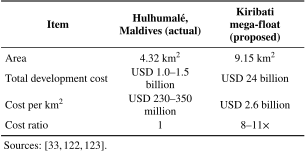
The cost difference between the two approaches is substantial (Table 2). The proposed mega-float would cost approximately USD 2.6 billion per km\(^2\), whereas Hulhumalé’s total development cost, including housing and infrastructure, amounts to USD 230–350 million per km\(^2\)—approximately 8 to 11 times lower. This significant disparity suggests that while floating structures may offer certain advantages in terms of flexibility and tsunami resilience, their economic viability for large-scale permanent settlement remains questionable compared to proven reclamation approaches. The Hulhumalé experience demonstrates that lagoon-based reclamation represents a technically feasible and substantially more cost-effective alternative that warrants serious consideration for atoll countries such as Kiribati.
Kupferberg 116 raises another financial concern specific to the Temaiku project, noting that land reclamation alone would cost approximately USD 273 million—exceeding Kiribati’s annual GDP of approximately USD 194 million—and questioning whether such an investment is feasible for a small island developing state. However, comparative analysis suggests this cost is not unreasonable by international standards. The Temaiku reclamation cost translates to approximately USD 91 million per km\(^2\), whereas Hulhumalé’s total development cost—including reclamation, housing, roads, utilities, and other infrastructure—amounts to USD 230–350 million per square kilometer (Table 2). Thus, Temaiku’s per-unit-area reclamation cost represents only 26%–40% of Hulhumalé’s comprehensive development expenditure. Kupferberg’s critical point is not that the project is too expensive in absolute terms but that it exceeds Kiribati’s domestic financing capacity. However, Hulhumalé itself was not financed solely by the Maldivian government; it relied on international development finance institutions, bilateral aid, public-private partnerships, and reinvestment of housing sales revenues 122,123. This suggests the relevant question is not whether Temaiku’s costs are prohibitive but whether adequate international climate adaptation funding can be secured. The withdrawal of New Zealand government funding for Temaiku in 2021 119 underscores the project’s dependence on external support and its vulnerability to shifting donor priorities.
The legal, technological, and financial constraints examined above carry significant implications for Kiribati’s long-term adaptation pathway. Unlike some Pacific Island nations, where land tenure conflicts impede adaptation, Kiribati’s legal framework vesting reclaimed land in state ownership provides a relatively favorable foundation for projects such as Temaiku. Technologically, conventional reclamation remains substantially more cost-effective than alternatives such as floating structures. The critical constraint is financial: projects of the required scale exceed domestic fiscal capacity and depend on sustained international climate finance, as demonstrated by the withdrawal of donor funding for Temaiku. Nevertheless, Kiribati’s policy evolution from cautious resistance toward hard structural solutions to explicit endorsement of “bold and innovative engineering solutions” in the 2019 KJIP reflects growing recognition that incremental measures alone cannot secure long-term habitability.
4. Marshall Islands: Challenges and Opportunities
The Republic of the Marshall Islands (RMI) presents a critical case for understanding the governance and institutional barriers that constrain artificial island development as a climate adaptation strategy. Unlike the Maldives, where state-led reclamation has advanced at scale, RMI’s adaptation planning confronts a fundamental legal conflict: the constitutional authority for public land acquisition clashes with domestic legislation that vests reclaimed land in adjacent private owners, creating a structural barrier to securing international climate finance. Facing severe technological constraints, limited implementation capacity, and costs that far exceed national fiscal resources, RMI illustrates how transformative adaptation options may remain unattainable without prior resolution of foundational governance challenges.
The country faces acute exposure to SLR, wave-driven flooding, coastal erosion, and saltwater intrusion into fragile freshwater lenses that constitute its drinking water supply 124. These biophysical risks intersect with structural socioeconomic vulnerabilities: a small, aid-dependent economy centered on government services, fisheries, and copra; heavy reliance on imported food; and high population concentrations in urban atolls, such as Majuro and Ebeye, where land scarcity, overcrowding, and aging coastal infrastructure severely constrain options for retreat or on-site protection 124. In response, RMI’s recent climate strategies have moved beyond incremental measures, such as ad hoc seawalls, toward a more transformative agenda featuring large-scale land raising, selective reclamation, and strategic consolidation of people and services onto newly elevated sites, while recognizing that these interventions are bound by financial, legal, and technological constraints. Migration induced by climate change from atoll countries has begun toward the United States, particularly in Arkansas, Hawaii, and Washington State; however, these migrants are pushed by climate risks and economic, educational, and healthcare considerations 125.
Furthermore, the 1951 Refugee Convention does not include climate or environmental change among the grounds for refugee status, leaving climate-induced migrants in legal limbo 24. This gap has prompted calls for new international frameworks addressing climate displacement, including proposals such as “climate passports” and recognition of a “right to migrate” as a form of climate adaptation. Simultaneously, many atoll communities, including those in the Marshall Islands, strongly assert a “right to stay”: the principle that adaptation support should enable people to remain in their homelands rather than be forced into relocation 20. This tension between migration as adaptation and resistance to displacement-oriented solutions mirrors deeper questions about agency, cultural preservation, and the responsibilities of high-emitting countries in supporting in-place adaptation in highly vulnerable states, such as RMI. This section examines RMI to assess the technical feasibility and costs of artificial land creation on atolls, alongside the governance, equity, and ecological questions that will determine whether such projects can sustain long-term habitability without exacerbating existing patterns of coastal erosion and social vulnerability.
4.1. Country Profile and Climate Vulnerability
RMI is located in the western Pacific Ocean, north of the equator, and west of the International Date Line. Comprising 29 atolls and five low coral islands, RMI has a landmass of 181 km\(^2\) in total with an exclusive economic zone of 1,990,530 km\(^2\) 126. Recent World Bank data show a population of roughly 37,500–38,000 people in 2023, down from approximately 42,000 around 2022, reflecting continued outmigration 127. The economy is small and aid-dependent, with key sectors including government services, fisheries, copra, and small-scale commerce, and limited tourism 128. Approximately 80%–90% of food consumed in RMI is imported, making food security sensitive to external price and supply shocks 129. Limited arable land, poor soil, freshwater scarcity, and increasing climate impacts constrain domestic agriculture and make substantial increases in staple crop production difficult 130. The extreme topographic vulnerability exposes RMI to compound climate risks, including SLR, wave-driven flooding, coastal erosion, and saltwater intrusion into freshwater lenses that underpin domestic water supply 3. Recent modeling indicates that even under moderate emissions scenarios, many atolls in the Marshall Islands may experience annual wave-driven flooding sufficient to contaminate freshwater resources by mid-century, rendering large areas effectively uninhabitable well before permanent inundation occurs 1. RMI often faces repeated typhoons, which cause severe economic losses. For instance, Typhoon Paka in 1997 damaged agricultural areas and destroyed 80% of the houses in the Ailiniglaplap Atoll. This disaster brought significant financial losses to the entire nation, estimated at USD 80 million 127. Urban atolls in the Marshall Islands—particularly Majuro (the capital, with more than 20,000 residents) and Kwajalein—face severe inundation risk from SLR 127. Without adaptation measures, a 1-m rise in sea level could lead to permanent inundation of 37% of buildings in Majuro and over 50% of buildings in Ebeye, highlighting the urgent need for adaptation planning 127.
This section reviews RMI’s broader adaptation strategies before focusing on artificial island development as an emerging option. RMI’s recent adaptation plan highlights a gradual shift toward transformative adaptation pathways, including large-scale land raising, engineered reclamation, and planned internal relocation. In the Marshall Islands, such approaches are most frequently discussed for Majuro Atoll, where population density, infrastructure concentration, and economic activity are highest 131. In 2018, the Tile Til Eo 2050 Climate Strategy defined four key adaptation pathways for RMI: Protection; Elevation; Consolidation; and Relocation 132. Protection focuses on strengthening coastal defenses, climate-proofing infrastructure, and safeguarding community resilience, along with food, water, and health security 132. Elevation involves raising all new infrastructure and developing elevated settlements under updated building standards 132. Consolidation includes strategies to concentrate population in safer high-ground areas as climate impacts intensify 132. Relocation is considered a last-resort option, ensuring the right to remain on the islands and the provision of dignified migration pathways if long-term habitability can no longer be sustained 132.
Building seawalls and other physical defenses has been used as a conventional adaptation strategy. RMI has constructed seawalls, mostly via the private sector, particularly along Majuro’s valuable coastline. For example, a 450-m-long seawall near the new stadium on Majuro was built to mitigate the indirect impact of the existing seawall, with a budget of USD 1 million 133. However, recent assessments by the World Bank in 2021 revealed that conventional protection measures alone may be insufficient under high SLR scenarios. In such cases, large-scale land reclamation and engineered land raising are increasingly discussed as unavoidable last-resort adaptation options to maintain the habitability of key atolls such as Majuro, despite their financial, environmental, and technical costs 127.
RMI’s NAP identifies land reclamation and land raising as core long-term adaptation measures for maintaining habitability under projected SLR, particularly beyond the 0.5 m SLR threshold (around 2070) and up to 2 m SLR by 2150 133. In highly urbanized areas such as Majuro and Ebeye, raising land within existing city centers is considered economically and technically impractical because of groundwater salinization, drainage and dewatering requirements, and construction constraints. Consequently, the strategy emphasizes the creation of new elevated land through selective reclamation or raising of less-developed islands, enabling the consolidation of population, government functions, and critical infrastructure into new centers. Cost estimates indicate unit costs of approximately USD 800/m\(^2\) for raising land with rebuilding (1 m SLR) and USD 1,500/m\(^2\) for raising land with revetments (2 m SLR), with higher protection standards substantially reducing the area and population that can be accommodated per dollar invested 133. For example, an investment of USD 500 million could create about 0.63 km\(^2\) of elevated land under a 1 m SLR design, compared with 0.33 km\(^2\) under a 2 m SLR design, accommodating up to approximately 25,000 and 13,000 people, respectively, under high-density assumptions. Island-scale estimates further show that elevating individual islets to withstand long-term SLR typically requires up to several billion USD, making nationwide reclamation infeasible 133. Consequently, the NAP concludes that reclamation and raising land must be applied selectively, at high densities, and in a phased manner, forming part of a broader adaptation pathway that ultimately prioritizes strategic consolidation over the comprehensive protection of all existing atolls.
4.2. Artificial Island Development Prospects
Artificial islands have also emerged as climate adaptation infrastructure; however, they remain a controversial approach. Nakayama et al. identified land reclamation and elevation as one of four major adaptation options for RMI, and more recent work has started to examine the technical feasibility and social acceptability of artificial islands as tools to operationalize the “right to stay” 134. In the Pacific, artificial island development faces context-specific technical and cultural challenges that differ markedly from those of land reclamation in continental settings. Atoll-based artificial islands must often be constructed in deeper waters with limited sediment sources, requiring designs that can maintain structural stability during extreme weather, prevent erosion, preserve sufficient elevation above future sea levels, and support essential infrastructure such as freshwater supply, sewage treatment, and renewable energy 135. For Marshallese communities, these engineering issues intersect with profound cultural considerations because people–land relationships are deeply rooted in particular atolls and islets, tied to ancestral heritage and matrilineal land-tenure systems. Relocating to “artificial” land that is detached from customary tenure and ancestral sites; therefore, challenges core dimensions of Marshallese identity and social organization 136. Existing research on Marshallese views toward artificial islands is mixed. Some studies suggest conditional openness, where such projects allow people to remain within national waters and retain sovereignty, while others highlight strong spiritual and emotional bonds to ancestral lands that may be difficult to reproduce on engineered substrates 125. These accounts also point to concerns about losing traditional land connections, doubts about whether culture and community can truly be transplanted to new landforms, and skepticism that artificial islands can replicate the complex ecological and social systems of natural atolls.
4.3. Legal, Technological, and Financial Constraints
RMI faces a key legal constraint in implementing its reclamation-based adaptation strategy, primarily a conflict between its Constitution, which allows government land acquisition for public use, and a domestic law that vests reclaimed land in adjoining private owners 137. Sec.105 of the 2008 Public Lands and Resources Amendment Act states that reclaimed land automatically becomes the property of adjoining private owners; however, Art. II, Sec.5 of RMI’s Constitution authorizes the government to acquire land for public use, including through reclamation 137. This key legal issue hinders climate adaptation funding tied to public-purpose projects, as the required billions of dollars in funding for the NAP must be donated for public purposes rather than private benefits. According to Bernard Adiniwin (who has worked as the Attorney General since March 2022), uncertainty over whether reclaimed land is public or private directly undermines the ability to structure and justify large-scale adaptation investments. He filed a petition against Speaker Brenson Wase in the High Court at the end of September 2025. However, High Court Judge Anne Bodley ruled against the government in her 18-page decision 138. While the judge ordered the deletion of the introductory phrase “notwithstanding the provision of any law to the contrary” from Sec.105 of the 2008 Landfill Act, she upheld the core provision: title to new land created through landfill from marine areas below the ordinary high-water mark shall vest in the owners of the adjoining land. This ruling confirms that reclaimed land funded by the government or donors will automatically become private property, potentially complicating efforts to secure international funding for the NAP because donors typically refuse to fund projects that benefit private entities.
Table 3. Estimated land area and population that can be accommodated on newly raised land in RMI under different investment levels, unit costs, and population densities.
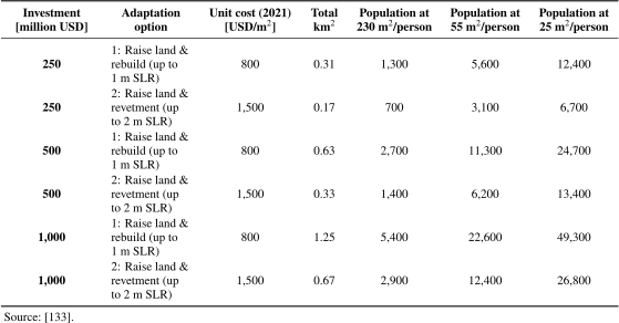
RMI’s land-elevation and reclamation strategy also faces significant technological constraints alongside legal and financial barriers. From geotechnical and engineering design perspectives, the atolls comprise narrow, low-lying coral limestone and sand; hence, raising land by several meters requires a large volume of fill and sophisticated geotechnical design to ensure stability and avoid erosion or settlement 139. As the goal is to remain above SLR, storm surge, and wave run-up, designs must consider higher elevations, robust coastal protection, and integrated drainage to prevent chronic flooding from rainfall and overtopping. Densely populated urban atolls such as Majuro and Ebeye need to be raised by up to 3–4 m 139, making it difficult to sequence phased construction while maintaining essential services, public facilities, and evacuation routes during implementation. Implementation capacity and long-term operability present additional technological risks. Large dredging vessels, heavy machinery, and specialized engineers are largely sourced from overseas, and RMI’s remoteness and limited port capacity tend to inflate project costs and construction timelines. Moreover, the long-term maintenance of elevated land—addressing settlement, erosion, coastal defense repair, and drainage system upkeep—requires technical expertise and financial resources that are not yet fully available domestically. Consequently, post-construction maintenance and operational sustainability remain critical technological uncertainties in the reclamation-based adaptation strategy.
Further technological constraints involve the need to minimize environmental damage; using technology and optimization to reduce the impact on sand movement and reef ecology for planning seawalls, rising lands, and reclamation is essential but challenging. Xue’s study indicates that coastal erosion is mainly caused by human activities, including sand excavation and the construction of causeways, artificial channels, and landfill, among others 140. Vertical seawalls, protruding landfills, artificial channels, and large wharves are listed as human-induced causes that either block longshore sediment transport or divert sand offshore—reclamation for cargo wharves and fuel depots has eliminated the space on reef flats where sand could otherwise accumulate 140. Since World War II, low-cost aggregates have been excavated, mainly from beaches and reef flats along the eastern lagoon coast, to build runways, causeways, wharves, and housing, significantly reducing the supply of sand to the lagoon shore 140. Further research indicates that the reclamation of reef flats and channels would result in the loss of foraminiferal habitats and create differences in water circulation patterns 141. Osawa et al. show that pier construction and associated human activities on the northeastern reef flat of Majuro degrade communities of large benthic foraminifers, which are key producers of carbonate sand, implying that coastal structures should be designed to minimize disruption to these biological sand factories 141. Additionally, studies on ecosystem-based coastal protection for atoll countries emphasize the role of coral reefs, seagrass, and coastal vegetation as natural buffers, and warn that hard structures such as vertical seawalls can interfere with sediment transport and ecological processes that underpin long-term shoreline stability 140. Hence, technologies that minimize the risks of coastal erosion and changes to coastal ecology must be considered to reduce existing erosion risks.
RMI’s reclamation plan is constrained by financing challenges. Large-scale land reclamation and elevation projects require extensive capital investment for dredging, material transport, coastal protection structures, and long-term maintenance, which far exceeds the fiscal capacity of the RMI government. The RMI economy is highly dependent on fisheries and external development assistance, particularly grants provided under the Compacts of Free Association. In 2021 (at constant 2021 prices), the RMI received approximately USD 330 million in climate-related development finance in the form of grants, equivalent to approximately 130% of its GDP 142. According to the Organisation for Economic Co-operation and Development (OECD) data, the World Bank was the largest contributor, accounting for 32% of total financing, followed by the GCF (23%) and Japan (16%) in 2024 143,144.
Estimates for implementing the NAP run into several billion USD, making the country heavily dependent on external climate finance and donor support (Table 3). With an investment of USD 250 million, raised land could accommodate approximately 1,300 people under low-density settlement patterns (230 m\(^2\) per person) or up to 12,400 people at high density (25 m\(^2\) per person) 133. Scaling up to USD 2 billion increases the potential capacity to between 10,900 and 100,000 people across the same density range. Land-raising and rebuilding strategies designed to withstand 1 m of SLR, at an estimated cost of USD 800 per m\(^2\), consistently yield approximately twice the usable land area and population capacity compared to designs incorporating revetments for 2 m SLR, which cost around USD 1,500 per m\(^2\) 133. Island-level estimates further underscore the magnitude of financial constraints: elevating individual islets typically requires investments ranging from several hundred million to multiple billions of USD, whereas larger islands may exceed USD 4 billion under higher protection standards 133. These estimates indicate that targeted, high-density consolidation on newly raised land is substantially more cost-effective than the uniform elevation of all existing islands. Nevertheless, even this comparatively efficient approach would depend heavily on sustained external financing and comprehensive long-term planning to ensure economic viability and long-term habitability.
To summarize, the RMI case suggests that conventional seawalls alone are increasingly inadequate as a long-term adaptation strategy in the context of accelerating SLR. While seawalls can provide short-term, site-specific protection, they do not address fundamental constraints such as land scarcity, chronic flooding, freshwater salinization, or the need to sustain urban functions in densely populated atolls such as Majuro. As climate impacts intensify, reliance on piecemeal coastal defenses risks locking the country into escalating maintenance costs, while failing to preserve long-term habitability. Conversely, artificial islands, employing land raising and selective reclamation, offer a more strategic pathway by creating elevated, consolidated spaces that can support housing, infrastructure, and essential services over longer time horizons. These approaches are better aligned with the “right to stay” for Marshallese communities, enabling in-place adaptation rather than displacement. However, their feasibility on the Marshall Islands remains highly constrained due to unresolved land tenure laws, limited technical capacity, ecological risks, and extreme financial requirements. Overall, while engineered land elevation represents a more promising long-term alternative to seawalls, its success depends on substantial governance reform, ecological safeguards, and sustained international financing, rather than engineering solutions alone.
5. Tuvalu: Challenges and Opportunities
The Tuvaluan case illustrates the structural limitations of engineering-led adaptation in the absence of scale, fiscal capacity, and legal certainty. Rather than representing a failure of technology per se, it underscores the political, economic, and legal preconditions under which artificial island strategies may or may not be viable for atoll countries. Tuvalu represents the most resource-constrained case among the four atoll countries examined in this review, demonstrating the severe limitations faced by the smallest and most vulnerable states in pursuing artificial island development as a climate adaptation strategy. Unlike the Maldives, where diversified financing and established governance capacity have enabled large-scale reclamation, or even Kiribati and the Marshall Islands, where transformative projects have at least reached advanced planning stages, Tuvalu’s engagement with engineered land solutions remains largely at the pilot scale through the World Bank-supported Tuvalu Coastal Adaptation Project (TCAP). Specifically, the case reveals how financial requirements that far exceed available resources, governance limitations that hinder effective implementation, technical uncertainties inherent in atoll environments, and inadequate international legal clarity regarding sovereignty preservation combine to constrain the viability of artificial islands as adaptation measures. These interconnected challenges suggest that, while engineering solutions may form part of comprehensive adaptation portfolios, they cannot serve as singular solutions to the existential threats facing the smallest low-lying atoll country.
5.1. Country Profile and Climate Vulnerability
Tuvalu is a low-lying atoll country in the central Pacific Ocean, comprising nine inhabited islands with a total land area of approximately 26 km\(^2\) 145,146. The country is highly vulnerable to SLR, coastal erosion, and flooding 147,65. Population and infrastructure are heavily concentrated in Funafuti, where land scarcity is a major issue owing to its high population density 147,65. These geographic and demographic characteristics constrain adaptation options and intensify interest in engineered land-based solutions.
In the case of Tuvalu, “artificial island development” should be understood not as the construction of entirely new, elevated islands akin to Hulhumalé, but rather as a continuum of engineered land interventions, ranging from coastal reclamation and elevation of existing islets to hypothetical future artificial islands.
5.2. Artificial Island Development Prospects
Artificial island construction and land reclamation have emerged within policy discourse as potential long-term adaptation strategies for Tuvalu. Although large-scale, elevated artificial islands designed to host significant population resettlement have not been operationalized, smaller-scale reclamation and elevation initiatives have begun to be implemented. The consideration of engineered land solutions reflects acute constraints faced by this low-lying atoll country, where land scarcity, population concentration, and escalating climate risks intersect to produce profound habitability concerns 45. However, it is essential to recognize that discussions of artificial islands in the Tuvaluan context have not progressed to the implementation stage witnessed in other jurisdictions, and their feasibility remains subject to considerable uncertainty.
The rationale for exploring artificial island options in Tuvalu stems from several interrelated factors. With a total land area of approximately 26 km\(^2\) and an average height above sea level of less than 3 m, Tuvalu possesses minimal capacity to accommodate population displacement resulting from coastal erosion, saltwater intrusion, and inundation 145,146. The capital city, Funafuti, experiences acute land pressure, with more than half of the national population residing on an atoll where habitable land is severely constrained by the surrounding lagoon. Projections of SLR under various emissions scenarios suggest that substantial portions of existing land may become uninhabitable within decades, creating imperatives for adaptation measures that extend beyond conventional coastal protection 42.
Land reclamation has been discussed within the government and international development forums as a means of increasing habitable land area, and the TCAP—supported by the World Bank and launched in 2017—represents the most substantial and concrete engagement with engineered land solutions undertaken in Tuvalu to date 148. TCAP encompasses coastal protection infrastructure, land reclamation, and the elevation of vulnerable areas in Funafuti, with the primary objective of enhancing the resilience of existing settlements rather than creating new artificial island territory 149. The project involves reclaiming approximately 15 ha of land from the lagoon, raising ground levels to reduce flood vulnerability, and constructing seawalls and revetments to protect critical infrastructure, including government buildings and the hospital 150,151. TCAP demonstrates that engineered measures, such as reclamation and elevation, can be implemented in Funafuti.
It is important to distinguish Tuvalu’s position from that of nations such as the Maldives, where artificial island construction has advanced considerably through projects such as Hulhumalé 34. The Maldives benefits from greater financial resources, a larger population base, a more developed governance infrastructure, and established tourism revenue streams that have enabled the pursuit of more capital-intensive adaptation strategies 63. Tuvalu lacks comparable economic capacity and institutional resources, rendering large-scale implementation significantly more challenging.
Ecological constraints constitute a key limiting factor in the design of the TCAP, with environmental assessments indicating that lagoon-side reclamation in Funafuti must remain spatially restricted to mitigate unavoidable impacts on marine ecosystems 152. The financial requirements for creating and maintaining reclaimed land far exceed Tuvalu’s fiscal capacity and would necessitate sustained international support, as evidenced by the TCAP’s multi-million-dollar budget funded primarily through international climate finance 153. Furthermore, unresolved questions regarding the status of artificial islands under international maritime law introduce uncertainty about whether such interventions would preserve existing exclusive economic zone entitlements, which constitute a crucial element of national sovereignty and economic viability 154.
Consequently, while artificial islands and land reclamation remain within the spectrum of discussed adaptation options for Tuvalu, their prospects must be characterized as highly conditional. Implementation would depend upon securing unprecedented levels of climate financing, resolving complex technical and environmental challenges, achieving clarity on legal and sovereignty implications, and maintaining political commitment across extended timeframes. Currently, these engineering solutions represent aspirational possibilities rather than imminent interventions, and their ultimate viability remains uncertain, pending further technical assessments, financial commitments, and international legal development.
5.3. Legal, Technological, and Financial Constraints
As traditional adaptation measures prove insufficient, artificial islands and land reclamation have emerged as potential strategies for maintaining territorial integrity and sustaining habitability. However, these engineering solutions present substantial challenges across financial, governance, technical, and legal dimensions that warrant careful examination.
The financial barriers to implementing artificial island construction and land reclamation in Tuvalu are formidable. Small island developing states (SIDS) typically possess limited fiscal capacity, with narrow revenue bases dependent on fisheries access fees, remittances, and international aid 155. Land reclamation projects require substantial capital investment, as demonstrated above in TCAP 153. For Tuvalu, with a GDP estimated at approximately USD 60 million annually, such expenditure represents an insurmountable burden without extensive external financing 156.
International climate finance mechanisms, including the GCF and Adaptation Fund, theoretically provide potential funding sources. However, accessing these resources presents considerable obstacles for nations with limited administrative capacity 157. The competitive nature of funding applications, complex procedural requirements, and lengthy approval processes disadvantage small countries that lack technical expertise in proposal development. Moreover, the prioritization of mitigation over adaptation in global climate finance architecture means that transformative engineering projects may struggle to secure adequate support 158.
The long-term financial sustainability of reclaimed land presents additional concerns. Maintenance costs for coastal protection structures, ongoing monitoring requirements, and potential reconstruction following extreme weather events create perpetual financial obligations that may exceed the initial construction expenditure over multidecadal timeframes 159. Without guaranteed sustained funding mechanisms, artificial islands risk becoming stranded assets that further strain national budgets.
These financial constraints intersect with significant governance and institutional challenges. Effective implementation of large-scale land reclamation requires robust institutional frameworks and technical capacity that often exceed the capabilities of small island states. The complexity of designing, tendering, implementing, and overseeing major infrastructure projects demands specialized expertise in coastal engineering, EIA, procurement management, and contract administration—skills that may necessitate extensive international consultancy support, especially in a country with limited economic capacity such as Tuvalu.
Governance challenges also extend to land tenure and customary ownership systems. In many Pacific contexts, including Tuvalu, land is communally held under customary arrangements that complicate state-led development initiatives 160. Reclamation projects may require negotiation with multiple landholding groups, raising questions about benefit distribution, compensation mechanisms, and decision-making authority. The potential for social conflict over newly created land, particularly regarding ownership rights and access, introduces governance complexities that technical solutions alone cannot resolve.
In parallel with physical adaptation strategies, Tuvalu has begun exploring innovative approaches to sovereignty preservation through digital means. The government’s “digital nation” initiative seeks to establish a virtual presence that could persist even if physical territory becomes uninhabitable, including digitizing government services and cultural heritage and potentially asserting continuing statehood through digital infrastructure 161. However, the governance capacity required to operationalize such novel approaches, including digital infrastructure development, international diplomatic engagement to establish precedents, and coordination with technology partners, represents additional institutional demands on an already constrained public administration. This initiative highlights a divergent adaptation pathway, one that decouples sovereignty from physical territory, implicitly challenging the premise that engineered land solutions are the only means of preserving statehood.
Beyond governance, the technical viability of artificial islands and land reclamation in atoll environments presents equally significant uncertainties. Atolls comprise coral reef structures surrounding lagoons, with limited availability of suitable fill material for reclamation 162. Extracting sand and aggregate from lagoon floors or reef systems risks damaging critical coastal protection functions and marine ecosystems that provide essential services such as fishery productivity and natural wave attenuation. Importing fill material from external sources escalates costs substantially while introducing additional logistical complexities.
Geotechnical conditions in atoll settings pose engineering challenges for supporting infrastructure and buildings on reclaimed land. The unconsolidated nature of fill material and underlying coral substrates may result in settlement issues, liquefaction risks during seismic events, and limitations on load-bearing capacity for structures 163. Ensuring adequate land stability requires careful engineering design, including ground improvement techniques, which further increase project costs.
Coastal dynamics and wave action in exposed atoll environments create ongoing threats to the integrity of reclaimed land. Climate change-induced increases in tropical cyclone intensity, changing wave patterns, and accelerating SLR may overwhelm coastal defense structures designed using historical parameters 1. The effectiveness of protection measures over 50–100-year timeframes remains uncertain, given the magnitude of projected environmental changes. Furthermore, reclamation that disrupts natural sediment transport processes or alters wave refraction patterns may inadvertently exacerbate erosion elsewhere in these interconnected atoll systems.
Finally, international law and sovereignty considerations introduce additional constraints. The implications of artificial islands for maritime zones and sovereignty under international law present complex challenges. The United Nations Convention on the Law of the Sea (UNCLOS) determines maritime entitlements—including territorial seas, EEZs, and continental shelf rights—based on naturally formed land territory 19. Art.60, Sec.8 of UNCLOS explicitly states that artificial islands do not possess the status of islands for purposes of generating maritime zones 164. This provision suggests that constructing artificial islands to replace submerging natural land may not preserve existing EEZ boundaries, potentially resulting in a substantial loss of maritime territory and associated resources.
The question of whether land reclamation on existing natural features maintains maritime entitlements lacks definitive resolution in international law 165. Although reclamation that augments existing islands may be viewed differently from entirely artificial structures, the proportion of artificial to natural land, changes to baseline determinations, and persistence of habitability remain controversial issues. For Tuvalu, whose EEZ encompasses approximately 750,000 km\(^2\) of ocean containing valuable fishery resources, uncertainty regarding maritime boundary preservation introduces profound concerns about long-term economic viability and sovereignty 19.
The potential for reclamation to be perceived as illegitimate by neighboring states or the international community presents additional risks. Accounts from disputed maritime regions suggest that alterations to contested maritime features can become politically and diplomatically sensitive, particularly when such actions intersect with unresolved claims under the law of the sea 166. Although Tuvalu’s circumstances differ fundamentally—as defensive adaptation rather than territorial expansion—establishing international acceptance of reclamation as legitimate climate adaptation requires diplomatic engagement and potentially new legal frameworks.
However, Tuvalu has achieved significant success in securing international financing for land reclamation as an adaptation measure. The TCAP has received substantial funding from the GCF and the World Bank 148,153, and the 2023 Falepili Union Treaty with Australia provides financial support for adaptation and migration pathways for Tuvaluan citizens 25. In this respect, Tuvalu may be considered more advanced than Kiribati in mobilizing international resources for engineered adaptation, despite its smaller economic base and more constrained institutional capacity. This contrast highlights the significant role of bilateral diplomatic arrangements and successful engagement with multilateral climate funds in enabling adaptation measures that would otherwise be beyond the fiscal reach of small island developing states.
In sum, artificial islands and land reclamation present multifaceted challenges that severely constrain their viability as climate adaptation strategies for Tuvalu. Financial requirements exceed available resources; governance limitations hinder effective implementation; technical feasibility remains uncertain in atoll environments; and international law provides inadequate clarity on the preservation of sovereignty. These interconnected challenges suggest that while engineering solutions may form part of comprehensive adaptation portfolios, they cannot serve as sole solutions to the existential threats faced by low-lying atoll countries.
6. Comparative Analysis Across Atoll Countries
The preceding country-specific sections reveal striking commonalities and significant divergences among the Maldives, Kiribati, the Marshall Islands, and Tuvalu in their approaches to artificial island development as climate adaptation. This comparative analysis synthesizes these findings to identify patterns, evaluate relative feasibility, and assess prospects for regional collaboration.
6.1. Common Challenges and Opportunities
6.1.1. Shared Climate Vulnerabilities
All four atoll countries face fundamentally similar existential threats arising from their geomorphological characteristics. Maximum elevations rarely exceed 3 m above mean sea level 42, and their carbonate substrates render freshwater lenses highly susceptible to saltwater intrusion 2,3. The dependence on surrounding coral reef systems for coastal protection—reefs dissipate up to 97% of wave energy 4—creates a shared vulnerability, as mass-bleaching events degrade these natural defenses 8. SLR projections of 0.28–1.01 m by 2100 under varying emission scenarios 6 threaten all four nations with wave-driven flooding and freshwater contamination by mid-century 1.
6.1.2. Universal Financial Constraints
The enormous capital requirements for artificial island development represent the most significant shared barrier. As Table 4 illustrates, estimated adaptation costs substantially exceed the fiscal capacities of all four nations. The Maldives faces estimated needs of USD 2–4 billion 98, the Marshall Islands requires investments ranging from several hundred million to multiple billions of USD for comprehensive island raising 133, and Tuvalu’s land reclamation projects require resources far exceeding domestic capacity. Even Kiribati’s modest Temaiku proposal would impose a substantial fiscal burden, with reclamation costs alone estimated at approximately USD 273 million, exceeding Kiribati’s annual GDP 116.
Table 4. Adaptation costs relative to GDP across atoll countries.
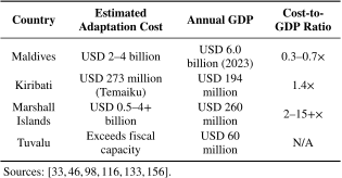
The GCF has approved only about USD 1.6 billion for all SIDS combined, representing roughly 12% of its total portfolio, with approximately 44% delivered as debt rather than as grants 40. This structural inadequacy in international climate finance constitutes a universal constraint requiring coordinated advocacy and innovative financing mechanisms.
6.1.3. Environmental Trade-Offs
All four nations must navigate the inherent tension between creating climate-resilient territories and protecting the marine ecosystems upon which their economies and cultures depend. Dredging operations physically remove benthic communities and generate sediment plumes that smother corals over wide areas 37. The Maldives’ experience demonstrates that reefs around reclamation sites suffer significantly greater mortality and fourfold increases in sand deposition than undisturbed areas 39. Given that coral reef health directly influences coastal protection and the tourism and fisheries sectors, which are critical to all four economies, this environmental trade-off presents a universal challenge that requires careful site selection and mitigation measures. The Maldives’ experience also reveals governance challenges in environmental protection. Civil society actors have raised concerns about the sequencing of EIA procedures relative to project contracting and commencement, and have sought judicial intervention to halt reclamation projects. In one notable case, the Supreme Court overturned a High Court construction halt order on the grounds that suspension would cause “significant losses to the national economy,” illustrating how tensions between development and environmental protection have entered judicial arenas 97,83.
Table 5. Governance and land tenure comparison.

6.1.4. Legal Uncertainties Under International Law
UNCLOS Article 60 establishes that artificial islands cannot claim territorial seas or exclusive economic zones 167, a principle reaffirmed in the 2016 South China Sea Arbitration. All four nations face uncertainty regarding the long-term status of maritime zones established from baselines, which may shift or disappear as sea levels rise 19. The potential implications for statehood under the Montevideo Convention criteria—requiring defined territory and permanent population 18—represent a shared existential concern that transcends technical adaptation questions. Regional coordination through mechanisms such as the CANCC 44 provides opportunities for collective advocacy on these legal dimensions.
6.1.5. Opportunities Through Demonstrated Feasibility
The successful implementation of land reclamation projects—most notably Hulhumalé in the Maldives and TCAP—demonstrates that artificial island development is technically achievable in atoll settings. Hulhumalé has created approximately 4.3 km\(^2\) of elevated land at approximately twice the elevation of natural Malé, with Phase 1 (188 ha) and Phase 2 (244 ha) creating land at approximately 2 m above mean sea level 62,34. TCAP successfully reclaimed approximately 15 ha of land using lagoon-sourced materials 150,151. These precedents provide valuable engineering knowledge, cost benchmarks, and proof-of-concept that benefit all atoll countries considering similar approaches.
6.1.6. The “Right to Stay” as Policy Foundation
Underlying the shared interest in artificial island development across all four nations is the concept of the “right to stay”: the principle that adaptation support should enable people to remain in their homelands rather than be forced into relocation 20. This stands in opposition to approaches that emphasize migration as the primary adaptive response to climate change. In the Marshall Islands, community consultations have revealed a strong rejection of external migration as an adaptation response among surveyed citizens, underscoring the political imperative for in situ solutions 125. Similarly, while Tuvalu’s Falepili Union Treaty with Australia provides migration pathways, the government’s policies explicitly emphasize support for residents choosing to remain. Thus, the right to stay provides a unifying policy foundation for artificial island development across diverse governance systems, linking technical adaptation measures to fundamental questions of sovereignty, cultural identity, and self-determination.
6.2. Country-Specific Factors
6.2.1. Governance Structures and Land Tenure
Perhaps the most consequential variation among the four nations lies in their governance frameworks and land-tenure systems, which fundamentally shape the feasibility of implementation (Table 5). The Maldives operates under a highly centralized system in which the state retains ownership of most land 57, enabling the government to undertake extensive reclamation without complex negotiations. The 2015 constitutional amendment, which created pathways for foreign investment in reclaimed land, further demonstrates this institutional flexibility 169.
Conversely, the Pacific atoll countries maintain customary land-tenure systems that require extensive community engagement. Kiribati’s Foreshore and Land Reclamation Ordinance (1969) vests state ownership in the foreshore and seabed, with reclaimed land becoming state property, providing some flexibility for adaptation projects. The Marshall Islands presents the most complex case, with its hierarchical Iroij–Alap–Ri-jerbal system embedded in matrilineal clans 170,59. A particularly acute governance challenge has emerged: a fundamental legal conflict between the Constitution, which authorizes government land acquisition for public purposes, including reclamation (Art. II, Sec.5), and Sec.105 of the 2008 Public Lands and Resources Amendment Act, which automatically vests reclaimed land in adjacent private landowners. In January 2026, the High Court upheld this statutory provision, ruling that land created through government-funded reclamation becomes private property. This legal uncertainty directly undermines the ability to structure international climate adaptation investments, as donors typically require funded projects to serve public rather than private purposes 138,171,172. Tuvalu’s Falekaupule system grants traditional assemblies substantial influence over local development decisions 61, requiring consensus-building processes that may slow but potentially strengthen community ownership of adaptation initiatives.
Table 6. Implementation status comparison.

6.2.2. Economic Capacity and Financing Mechanisms
Economic profiles vary substantially across the four nations, influencing domestic contribution capacity and access to international finance. The Maldives’ GDP per capita of approximately USD 11,486—the highest in South Asia—places it among upper-middle-income countries 46, enabling greater domestic resource mobilization and reducing eligibility for certain concessional finance mechanisms. Tourism generates nearly 30% of the GDP 173, providing a revenue base but also creating economic incentives that may conflict with environmental protection.
Pacific atoll countries possess a markedly lower economic capacity, with a GDP per capita of approximately USD 2,000 in Kiribati 46. The Marshall Islands benefits from COFA with the United States, renewed in March 2024 with USD 2.3 billion allocated over 20 years, including specific climate resilience provisions 174. Tuvalu’s 2023 Falepili Union Treaty with Australia establishes a migration pathway permitting approximately 280 Tuvaluan citizens per year to relocate to Australia, while reaffirming Tuvalu’s ongoing sovereignty 25. The inaugural ballot, held in mid-2025, attracted 8,750 applicants—more than half of the resident population 175. Kiribati lacks comparable bilateral arrangements, though its 3.55 million km\(^2\) EEZ—one of the largest in the Pacific—provides fishing license revenues 55.
6.2.3. Implementation Progress and Institutional Capacity
These four nations occupy very different positions along the implementation continuum (Table 6). The Maldives has accumulated over five decades of reclamation experience, with an estimated 2,500 ha created by 2020 39. HDC, established in 2001, provides dedicated institutional capacity for project implementation 122. Ongoing projects, including Hulhumalé Phase 2 and the planned Ras Malé development—which will reclaim 1,150 ha at elevations of 2–3 m—demonstrate sustained commitment and technical capability.
Tuvalu has transitioned from planning to early implementation through TCAP, with the project demonstrating that lagoon-based dredging can provide sufficient fill material for reclamation in Funafuti 150. Kiribati remains at the planning stage, with the Temaiku project proposing to reclaim approximately 300 ha at 2–5 m elevation 176, although site investigations have identified limited suitable lagoon sediments 177. Notably, Kiribati’s policy trajectory illustrates significant evolution: early frameworks, including the 2007 NAPA and the 2005 KAP Lands Acquisition and Resettlement Policy Framework, explicitly preferred “adaptation strategies that do not include hard structural solutions such as seawalls or related structures” 178. However, the 2019 KJIP marked a decisive shift, calling for “bold and innovative engineering solutions,” including raising islands to 2 m above sea level and integrating reclamation into land-use plans 104. The withdrawal of New Zealand government funding for the Temaiku project in 2021 119 underscores the vulnerability of transformative adaptation initiatives to external decision-making. The Marshall Islands occupies the earliest position, with its comprehensive NAP establishing a phased pathway extending to 2150, but with transformative interventions not envisioned until approximately 2070 133.
6.2.4. Population Dynamics and Spatial Constraints
Demographic pressures and migration patterns differ significantly across the four nations. The Maldives faces acute urban concentration, with more than 250,000 residents on the central island of Malé, which is less than 6.8 km\(^2\) 179 (the administrative area of Malé City is approximately 8.3 km\(^2\); see Section 1.1.3 and Table 1), creating immediate pressure for population dispersal that artificial islands can address. Similarly, South Tarawa in Kiribati experiences densities exceeding 3,500 persons per km\(^2\), with the most congested areas such as Betio reaching over 8,000 persons per km\(^2\) 104. Majuro in the Marshall Islands also faces severe population concentration with more than 20,000 residents 127.
The Marshall Islands presents a unique migration dynamic: approximately one-third of the Marshallese population already resides in the United States under Compact provisions 180, yet community consultations have revealed strong preferences for territorial preservation, underscoring the political imperative for in situ solutions 125. As detailed in Section 6.2.2, Tuvalu’s 2023 Falepili Union Treaty with Australia combines a structured migration pathway with an explicit commitment to supporting in situ adaptation 25. The Tuvaluan government’s policies explicitly emphasize support for residents choosing to remain, reflecting a dual-track approach that balances migration facilitation with territorial preservation. This model merits attention from other atoll countries seeking to provide population security without abandoning sovereign territory.
Table 7. Comparative feasibility assessment.
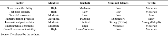
6.2.5. Technical and Environmental Constraints
Technical feasibility varies with local geomorphological conditions. The Maldives benefits from extensive lagoon systems with suitable sediment sources, as demonstrated through decades of successful dredging operations 34. Tuvalu’s TCAP similarly confirmed adequate lagoon materials for its more modest reclamation 150. Kiribati faces significant constraints, with site investigations confirming limited suitable lagoon sediments for the proposed Temaiku development 177. The floating mega-float concept proposed by Lister and Muk-Pavic 33 would circumvent sediment limitations but at dramatically higher costs—approximately USD 2.6 billion per km\(^2\) compared to USD 230–350 million per km\(^2\) for conventional reclamation at Hulhumalé 122,123.
6.3. Regional Cooperation Potential
6.3.1. Existing Cooperation Frameworks
The four atoll countries have demonstrated capacity for regional coordination through existing mechanisms. All four participate in the AOSIS, which has enabled them to have a collective voice in international climate negotiations 43. The formation of the CANCC in 2014 specifically addresses shared concerns regarding climate mobility and sovereignty 44. These platforms provide institutional foundations for deepened cooperation on artificial island development.
6.3.2. Knowledge Transfer Opportunities
The Maldives’ extensive experience offers substantial knowledge transfer potential for Pacific atoll countries. Hulhumalé provides concrete lessons regarding engineering approaches, cost management, environmental mitigation, and institutional arrangements. Technical specifications—including elevation standards, sediment sourcing, and coastal protection integration—developed through Maldivian projects can inform Pacific planning processes. The HDC’s operational model may offer insights into institutional capacity building in nations that lack dedicated implementing agencies.
Conversely, Pacific nations’ experience with customary land tenure and community engagement processes may inform approaches to social acceptance and equitable benefit-sharing that centralized Maldivian governance has not needed to develop. The Marshall Islands’ comprehensive community consultation process—which incorporates insights from citizen interviews for its NAP—demonstrates methodologies for building social license in contexts of complex traditional governance.
6.3.3. Collective Advocacy and Finance Mobilization
The inadequacy of current climate finance flows—only approximately USD 1.6 billion approved by GCF for all SIDS 40—underscores the need for collective advocacy. Joint proposals highlighting the unique circumstances of atoll countries and the transformational nature of artificial island development may prove more compelling for international funders than requests from individual countries. The formation of the CANCC signals recognition of this potential 44.
Innovative financing mechanisms can also be developed regionally. Debt-for-climate swaps, blue bonds linked to maritime zone preservation, and collective insurance arrangements represent possibilities that gain feasibility through regional scale. The disparity between the nations’ modest land areas and vast EEZs—ranging from \(1:\textrm{3,100}\) for the Maldives to approximately \(1:\textrm{35,000}\) for Tuvalu—suggests opportunities for financing linked to ocean resource management and conservation.
6.3.4. Joint Advocacy on Legal Frameworks
Shared uncertainty regarding maritime zone preservation and statehood criteria creates strong incentives for coordinated legal advocacy. Collective efforts to establish precedents for “freezing” maritime baselines regardless of physical land changes, or to develop new international instruments addressing climate-displaced states, would benefit all four nations. The Pacific Islands Forum’s 2021 “Declaration on Preserving Maritime Zones in the Face of Climate Change-Related SLR” provides a model for regional legal coordination that could be extended to artificial island-specific questions.
6.3.5. Barriers to Cooperation
Despite these opportunities, several factors constrain regional cooperation. Geographic separation—the Maldives lies in the Indian Ocean, while the three Pacific nations span vast distances—limits practical collaboration. Differing economic circumstances affect priorities and partnerships. The Maldives’ upper-middle-income status and tourism-dependent economy create distinct incentive structures from the aid-dependent Pacific economies. Bilateral relationships—the Marshall Islands’ Compact with the United States, Tuvalu’s Falepili Union Treaty with Australia, the Maldives’ complex relationships with India and China—may sometimes compete with multilateral coordination.
6.4. Synthesis: Toward a Comparative Framework
The comparative analysis reveals that artificial island feasibility varies substantially across the four nations based on the interaction of multiple factors (Table 7). The Maldives demonstrates the highest near-term feasibility due to favorable governance structures, established institutional capacity, proven technical experience, and relatively stronger economic capacity. Tuvalu has achieved important early implementation progress and benefits from international partnerships, though financial constraints remain binding. Kiribati possesses some institutional flexibility through state foreshore ownership but faces technical constraints and lacks bilateral support arrangements that benefit other nations. Despite developing the most comprehensive long-term planning framework, the Marshall Islands faces the most significant governance complexity and accordingly envisions the longest implementation timeline.
These variations suggest that no single model is suitable for all atoll countries. Rather, country-specific approaches calibrated to local governance systems, technical conditions, financial access, and community preferences offer the most promising pathway. Regional cooperation can nonetheless enhance collective advocacy, facilitate knowledge transfer, and potentially unlock financing mechanisms that are unavailable to nations acting alone.
7. Conclusions
This review has examined artificial island development as a climate change adaptation strategy across four atoll countries—the Maldives, Kiribati, the Marshall Islands, and Tuvalu—which face existential threats from SLR. The analysis reveals the transformative potential and substantial constraints of this approach.
7.1. Summary of Key Findings
The Maldives’ experience with Hulhumalé (approximately 430 ha at 2 m elevation) and Tuvalu’s TCAP (approximately 15 ha) demonstrate that artificial island construction is technically achievable in atoll environments. Hydraulic fill methods using lagoon-sourced sediments have proven effective, although sediment availability varies by location. Site investigations for Kiribati’s Temaiku project identified limited suitable lagoon sediments as a constraint.
Governance structures critically determine implementation prospects. The Maldives’ centralized state land ownership enables rapid project execution, as demonstrated by HDC’s management of Hulhumalé. Conversely, customary land-tenure systems in Pacific nations require complex negotiations. The Marshall Islands faces a particularly acute barrier: the legal conflict between constitutional provisions authorizing government land acquisition and the 2008 statute vesting reclaimed land in adjacent private owners directly undermines international climate finance eligibility.
Financial requirements represent the most significant shared barrier. Estimated adaptation costs—USD 2–4 billion for the Maldives, USD 273 million for Kiribati’s Temaiku reclamation alone, and up to several billion of USD for the Marshall Islands’ phased land raising—vastly exceed domestic fiscal capacities. GCF has approved only approximately USD 1.6 billion for all SIDS combined, with 44% delivered as debt rather than as grants. The withdrawal of New Zealand government funding for the Temaiku project in 2021 illustrates the vulnerability of transformative adaptation initiatives to external decision-making.
All four nations must navigate the tension between creating climate-resilient territory and protecting coral reef ecosystems. Dredging operations physically remove benthic communities and generate sediment plumes that damage corals. In the Maldives, reefs around reclamation sites have suffered significantly greater mortality than those in undisturbed areas. This trade-off is particularly consequential, given that coral reefs provide natural coastal protection and support tourism and fisheries sectors, which are critical to all four economies.
UNCLOS Article 60 establishes that artificial islands cannot generate territorial seas or exclusive economic zones. All four nations face uncertainty regarding the long-term status of maritime zones as sea levels rise and natural baselines shift or disappear. These unresolved questions have profound implications for sovereignty and resource access.
7.2. Country-Specific Conclusions
The Maldives has demonstrated the highest implementation capacity, with more than five decades of reclamation experience and approximately 2,500 ha created by 2020. Hulhumalé represents a successful model of climate-resilient urban development, although the environmental impacts on the surrounding reef systems and governance challenges in environmental oversight remain concerning.
Kiribati has evolved from a strong rejection of hard structural solutions in early adaptation frameworks to the endorsement of “bold and innovative engineering solutions” in the 2019 KJIP. The Temaiku project offers transformative potential for South Tarawa’s overcrowding and climate vulnerability but faces technical constraints from limited sediment availability and dependence on external financing.
The Marshall Islands has developed the most comprehensive long-term planning framework through its NAP, with a phased pathway extending to 2150. However, the unresolved legal conflict over reclaimed land ownership presents a fundamental barrier that must be addressed before large-scale implementation can proceed. The NAP envisions transformative interventions beginning only around 2070.
Tuvalu has transitioned from planning to early implementation through TCAP, demonstrating that engineered land solutions can be realized even in the most resource-constrained contexts when international support is secured. The project’s successful reclamation of approximately 15 ha provides proof-of-concept for future phases, although financial and institutional constraints remain binding.
7.3. Overall Assessment
Artificial island development can serve as an effective climate adaptation strategy under specific conditions: clear legal frameworks for land acquisition, availability of suitable sediment sources, access to international climate finance, effective environmental mitigation, and community acceptance. The four nations occupy distinctly different positions along the implementation continuum, with feasibility determined by the interaction between governance capacity, technical conditions, and financial access.
The “right to stay” concept provides the unifying policy foundation across all four nations. Political leaders have consistently rejected external migration as a primary adaptation strategy, emphasizing sovereignty, cultural continuity, and the right to remain in ancestral homelands. Artificial island development, despite its costs and complexities, offers a pathway to honor this commitment.
However, engineering solutions alone cannot address the existential threats faced by atoll countries. Successful implementation requires integrated governance reform, sustained international financing at scales far exceeding current commitments, and careful environmental management to avoid undermining the natural coastal protection systems upon which these nations also depend.
7.4. Limitations and Future Research
This review focuses on technical, financial, legal, and governance dimensions of artificial island development. Several areas warrant further investigation: the long-term social and cultural implications of population relocation to artificial islands; the effectiveness of environmental mitigation measures over decadal timescales; evolving international legal frameworks for climate-affected states; and comparative cost-effectiveness of artificial islands versus other transformational adaptation options.
The question that the international community faces is not primarily whether artificial islands are technically feasible—the Maldives has demonstrated that they are—but whether sufficient resources and political will can be mobilized to support this transformational adaptation at the required scale. For atoll countries that assert their right to stay, the answer has existential implications.
If, however, the international community is unable or unwilling to mobilize the resources required for in situ adaptation at the necessary scale, the consequences will extend beyond the atoll countries themselves. Countries across the Pacific Rim and other regions may ultimately be compelled to determine the number of climate migrants they are willing and able to accept. This question has profound implications for international solidarity, burden-sharing, and the future of climate justice. The Falepili Union Treaty between Tuvalu and Australia may represent an early precedent for such arrangements. However, the potential scale of climate-induced displacement from vulnerable coastal and island communities worldwide would require responses of an entirely different magnitude.
Appendix A. International Legal, Policy, and Scientific Frameworks Relevant to Artificial Island Development in Atoll Countries
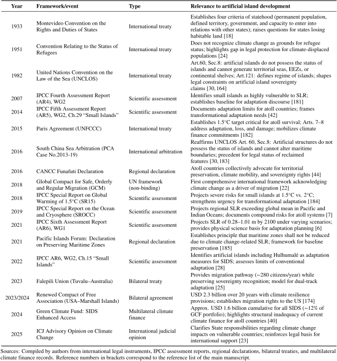
Acknowledgments
The preparation of this review article was supported by the Global Infrastructure Fund Research Foundation, Japan.
- [1] C. D. Storlazzi, S. B. Gingerich, A. van Dongeren et al., “Most atolls will be uninhabitable by the mid-21st century because of sea-level rise exacerbating wave-driven flooding,” Sci. Adv., Vol.4, No.4, Article No.eaap9741, 2018. https://doi.org/10.1126/sciadv.aap9741
- [2] R. T. Bailey, J. W. Jenson, and A. E. Olsen, “Numerical modeling of atoll island hydrogeology,” Groundwater, Vol.47, Issue 2, pp. 184-196, 2009. https://doi.org/10.1111/j.1745-6584.2008.00520.x
- [3] I. White and T. Falkland, “Management of freshwater lenses on small Pacific islands,” Hydrogeol. J., Vol.18, No.1, pp. 227-246, 2010. https://doi.org/10.1007/s10040-009-0525-0
- [4] F. Ferrario, M. W. Beck, C. D. Storlazzi et al., “The effectiveness of coral reefs for coastal hazard risk reduction and adaptation,” Nat. Commun., Vol.5, Article No.3794, 2014. https://doi.org/10.1038/ncomms4794
- [5] C. T. Perry, L. Alvarez-Filip, N. A. J. Graham et al., “Loss of coral reef growth capacity to track future increases in sea level,” Nature, Vol.558, No.7710, pp. 396-400, 2018. https://doi.org/10.1038/s41586-018-0194-z
- [6] IPCC, “Climate change: The physical science basis,” V. Masson-Delmotte et al. (Eds.), “Contribution of Working Group I to the Sixth Assessment Report of the Intergovernmental Panel on Climate Change,” Cambridge University Press, 2021. https://doi.org/10.1017/9781009157896
- [7] Intergovernmental Panel on Climate Change, “IPCC special report on the ocean and cryosphere in a changing climate,” Cambridge University Press, 2019. https://www.ipcc.ch/site/assets/uploads/sites/3/2019/12/SROCC_FullReport_FINAL.pdf [Accessed July 14, 2026]
- [8] T. P. Hughes, K. D. Anderson, S. R. Connolly et al., “Spatial and temporal patterns of mass bleaching of corals in the Anthropocene,” Science, Vol.359, No.6371, pp. 80-83, 2018. https://doi.org/10.1126/science.aan8048
- [9] O. Hoegh-Guldberg, E. S. Poloczanska, W. Skirving et al., “Coral reef ecosystems under climate change and ocean acidification,” Front. Mar. Sci., Vol.4, Article No.158, 2017. https://doi.org/10.3389/fmars.2017.00158
- [10] Australian Bureau of Meteorology, CSIRO, “Climate variability, extremes and change in the western tropical Pacific,” Pacific-Australia Climate Change Science and Adaptation Planning Program, 2014. https://www.pacificclimatechangescience.org/wp-content/uploads/2014/07/PACCSAP_CountryReports2014_WEB_140710.pdf [Accessed July 14, 2026]
- [11] T. Knutson, S. J. Camargo, J. C. L. Chan et al., “Tropical cyclones and climate change assessment: Part II,” Bull. Am. Meteorol. Soc., Vol.101, Issue 3, pp. E303-E322, 2020. https://doi.org/10.1175/BAMS-D-18-0194.1
- [12] Government of Kiribati, “Kiribati 2015 population and housing census,” National Statistics Office, 2016. https://microdata.pacificdata.org/index.php/catalog/199 [Accessed July 14, 2026]
- [13] National Bureau of Statistics, “Statistical yearbook of Maldives 2022,” Government of Maldives, 2022. https://statisticsmaldives.gov.mv/yearbook/2022/ [Accessed July 14, 2026]
- [14] J. D. Bell, I. Senina, T. Adams et al., “Pathways to sustaining tuna-dependent Pacific Island economies during climate change,” Nat. Sustain., Vol.4, No.10, pp. 900-910, 2021. https://doi.org/10.1038/s41893-021-00745-z
- [15] Ministry of Tourism, “Tourism yearbook 2022,” Government of Maldives, 2022. https://www.tourism.gov.mv/en/statistics/dashboard [Accessed July 14, 2026]
- [16] Asian Development Bank, “Climate risk country profile: Kiribati,” Asian Development Bank, 2020. https://climateknowledgeportal.worldbank.org/sites/default/files/2021-06/15816-WB_Kiribati%20Country%20Profile-WEB.pdf [Accessed July 14, 2026]
- [17] C. D. Storlazzi, E. P. L. Elias, and P. Berkowitz, “Many atolls may be uninhabitable within decades due to climate change,” Sci. Rep., Vol.5, Article No.14546, 2015. https://doi.org/10.1038/srep14546
- [18] J. Crawford, “The creation of states in international law,” 2nd Edition, Oxford University Press, 2006. https://doi.org/10.1093/acprof:oso/9780199228423.001.0001
- [19] R. Rayfuse, “W(h)ither Tuvalu? International law and disappearing states,” UNSW Law Research Paper, No.2009-9, 2009.
- [20] J. McAdam, “Climate change, forced migration, and international law,” Oxford University Press, 2012. https://doi.org/10.1093/acprof:oso/9780199587087.001.0001
- [21] K. M. Teaiwa, “Consuming Ocean Island: Stories of people and phosphate from Banaba,” Indiana University Press, 2015.
- [22] United Nations (UN) General Assembly, “Global compact for safe, orderly and regular migration,” A/RES/73/195, 2018. https://docs.un.org/en/A/RES/73/195 [Accessed July 14, 2026]
- [23] International Court of Justice (ICJ), “Advisory opinion on the obligations of states in respect of climate change,” 2025. https://icj-web.leman.un-icc.cloud/sites/default/files/case-related/187/187-20250723-adv-01-00-en.pdf [Accessed July 14, 2026]
- [24] M. Burkett, “The nation ex-situ: On climate change, deterritorialized nationhood and the post-climate era,” Clim. Law, Vol.2, No.3, pp. 345-374, 2011. https://doi.org/10.3233/CL-2011-040
- [25] Government of Australia and Government of Tuvalu, “Australia-Tuvalu Falepili Union Treaty,” Signed at Rarotonga, 9 November 2023; entered into force 28 August 2024. https://www.dfat.gov.au/geo/tuvalu/australia-tuvalu-falepili-union-treaty/treaty-text-falepili-union [Accessed July 14, 2026]
- [26] H.-O. Pörtner et al. (Eds.), “Climate Change 2022: Impacts, Adaptation, and Vulnerability: Contribution of Working Group II to the Sixth Assessment Report of the Intergovernmental Panel on Climate Change,” Cambridge University Press, 2022. https://doi.org/10.1017/9781009325844
- [27] P. D. Nunn, “Responding to the challenges of climate change in the Pacific Islands,” Clim. Res., Vol.40, pp. 211-231, 2009. https://doi.org/10.3354/cr00806
- [28] M. Mycoo, M. Wairiu, D. Campbell et al., “Small islands,” H.-O. Pörtner et al. (Eds.), “Climate Change 2022: Impacts, Adaptation, and Vulnerability: Contribution of Working Group II to the Sixth Assessment Report of the Intergovernmental Panel on Climate Change,” Cambridge University Press, pp. 2043-2121, 2022. https://doi.org/10.1017/9781009325844.017
- [29] A. K. Naylor, “Island morphology, reef resources, and development paths in the Maldives,” Prog. Phys. Geogr., Vol.39, Issue 6, pp. 728-749, 2015. https://doi.org/10.1177/0309133315598269
- [30] I. Saunders, “Artificial islands and territory in international law,” Vanderbilt J. Transnatl. Law, Vol.52, Issue 3, pp. 643-689, 2019.
- [31] A. H. A. Soons, “Artificial islands and installations in international law,” Occasional Paper, No. 22, Law of the Sea Institute, 1974. https://repository.library.noaa.gov/view/noaa/9935 [Accessed July 14, 2026]
- [32] C. M. Wang, E. Watanabe, and T. Utsunomiya (Eds.), “Very large floating structures,” Taylor and Francis, 2008. https://doi.org/10.1201/9781482265927
- [33] N. Lister and E. Muk-Pavic, “Sustainable artificial island concept for the Republic of Kiribati,” Ocean Eng., Vol.98, pp. 78-87, 2015. https://doi.org/10.1016/j.oceaneng.2015.01.013
- [34] A. Sakamoto, K. Nishiya, X. Guo et al., “Mitigating impacts of climate change induced sea level rise by infrastructure development: Case of the Maldives,” J. Disaster Res., Vol.17, No.3, pp. 327-334, 2022. https://doi.org/10.20965/jdr.2022.p0327
- [35] G. Díaz Musmanni, “Hulhumalé, Maldives: Monumental climate adaptation effort raises hope in a threatened paradise,” Global Center on Adaptation, February 25, 2022. https://gca.org/hulumale-maldives-monumental-climate-adaptation-effort-raises-hope-in-a-threatened-paradise/ [Accessed January 20, 2026]
- [36] R. J. Nicholls, D. Lincke, J. Hinkel et al., “A global analysis of subsidence, relative sea-level change and coastal flood exposure,” Environ. Res. Clim., Vol.2, No.1, Article No.012001, 2023. https://doi.org/10.1088/2752-5295/ac8594
- [37] P. L. A. Erftemeijer, B. Riegl, B. W. Hoeksema et al., “Environmental impacts of dredging and other sediment disturbances on corals: A review,” Mar. Pollut. Bull., Vol.64, Issue 9, pp. 1737-1765, 2012. https://doi.org/10.1016/j.marpolbul.2012.05.008
- [38] V. K. E. Duvat, “Human-driven atoll island expansion in the Maldives,” Anthropocene, Vol.32, Article No.100265, 2020. https://doi.org/10.1016/j.ancene.2020.100265
- [39] M. Montefalcone, C. Morri, C. N. Bianchi et al., “Synergic effect of global thermal anomalies and local dredging activities on coral reefs of the Maldives,” Mar. Pollut. Bull., Vol.160, 111585, 2020. https://doi.org/10.1016/j.marpolbul.2020.111585
- [40] Green Climate Fund, “Enhancing access to climate finance for small island developing states,” 2024. https://www.greenclimate.fund/event/enhancing-access-climate-finance-small-island-developing-states [Accessed July 14, 2026]
- [41] Climate Policy Initiative, “State and trends of climate adaptation finance in small island developing states,” Climate Policy Initiative, 2025. https://www.climatepolicyinitiative.org/publication/state-and-trends-of-climate-adaptation-finance-in-small-island-developing-states/? [Accessed July 14, 2026]
- [42] L. A. Nurse, R. F. McLean, J. Agard et al., “Small islands,” V. R. Barros, C. B. Field, D. J. Dokken et al. (Eds.) “Climate change 2014: Impacts, adaptation, and vulnerability,” pp. 1613-1654, Cambridge University Press, 2014. https://www.ipcc.ch/site/assets/uploads/2018/02/WGIIAR5-Chap29_FINAL.pdf [Accessed July 14, 2026]
- [43] A. Thomas and L. Benjamin, “Policies and mechanisms to address climate-induced migration in Pacific and Caribbean small island developing states,” Int. J. Clim. Chang. Strateg. Manag., Vol.10, Issue 1, pp. 86-104, 2017. https://doi.org/10.1108/IJCCSM-03-2017-0055
- [44] Coalition of Atoll Nations on Climate Change (CANCC), “Funafuti Declaration,” Funafuti (TV), October 7, 2016. https://mfed.gov.ki/sites/default/files/2025-06/Funafuti%20Declaration%20Signed%208%20Oct%202016.pdf [Accessed July 14, 2026]
- [45] L. Yamamoto and M. Esteban, “Atoll island states and international law,” Springer, 2014. http://ndl.ethernet.edu.et/bitstream/123456789/77531/1/35.pdf [Accessed July 14, 2026]
- [46] World Bank, “World Development Indicators 2023,” World Bank, 2023. https://databank.worldbank.org/source/world-development-indicators [Accessed July 14, 2026]
- [47] Central Intelligence Agency (CIA), “The World Factbook 2024,” 2024. https://www.cia.gov/the-world-factbook/ [Accessed July 14, 2026]
- [48] Pacific Community, “Pacific Data Hub 2023,” SPC, 2023. https://pacificdata.org/ [Accessed July 14, 2026]
- [49] Permanent Mission of the Republic of the Marshall Islands to the United Nations, “Country Facts,” United Nations. https://www.un.int/marshallislands/marshallislands/country-facts [Accessed January 20, 2026]
- [50] Malé City Council, “Statistics,” Malé City Council, 2026. https://malecity.gov.mv/en/statistics [Accessed January 20, 2026]
- [51] “South Tarawa – Population trends and demographics,” CityFacts. https://www.city-facts.com/tarawa/population [Accessed January 20, 2026]
- [52] M. Issitt, “Majuro, Marshall Islands,” EBSCO Information Services, 2025. https://www.ebsco.com/research-starters/geography-and-cartography/majuro-marshall-islands [Accessed January 20, 2026]
- [53] World Population Review, “Funafuti population 2025,” World Population Review, 2025. https://worldpopulationreview.com/cities/tuvalu/funafuti [Accessed January 20, 2026]
- [54] UNESCO World Heritage Centre, “The Pacific atoll-island cultural landscape of Tuvalu,” UNESCO, January 24, 2024. https://whc.unesco.org/en/tentativelists/6707/ [Accessed January 20, 2026]
- [55] D. Storey and S. Hunter, “Kiribati: An environmental ‘perfect storm’,” Aust. Geogr., Vol.41, Issue 2, pp. 167-181, 2010. https://doi.org/10.1080/00049181003742294
- [56] J. Connell, “Vulnerable islands: Climate change, tectonic change, and changing livelihoods in the Western Pacific,” Contemp. Pac., Vol.27, No.1, pp. 1-36, 2015. https://doi.org/10.1353/cp.2015.0014
- [57] Constitution of the Republic of Maldives, “Article 238,” 2008. https://faolex.fao.org/docs/pdf/mdv136135.pdf [Accessed July 14, 2026]
- [58] World Bank, “South Tarawa Water Supply Project (STWSP): Project information document – Integrated safeguards data sheet,” Report No.P162938, World Bank, 2018. https://documents.worldbank.org/en/publication/documents-reports/documentdetail/396751536746086581 [Accessed July 14, 2026]
- [59] L. M. Carucci, “Nuclear nativity: rituals of renewal and empowerment in the Marshall Islands,” Northern Illinois University Press, 1997.
- [60] B. R. Johnston (Ed.), “Half-lives, half-truths, and other radioactive legacies of the Cold War,” School for Advanced Research Press, 2007. https://sarpress.org/wp-content/uploads/2017/07/sar_press_half_live_and_half_truths.pdf [Accessed July 14, 2026]
- [61] “Falekaupule Act 1997,” Laws of Tuvalu, Chapter 4.08, 1997. https://faolex.fao.org/docs/pdf/tuv169401.pdf [Accessed July 14, 2026]
- [62] Housing Development Corporation, “Hulhumalé Phase II master plan,” HDC Ltd., 2019. https://www.hdc.mv/app/files//2024/10/Hulhumale-Phase-2-Planning-Development-Guidelines-V_1.0-2.pdf [Accessed January 22, 2026]
- [63] B. K. Sovacool, “Perceptions of climate change risks and resilient island planning in the Maldives,” Mitig. Adapt. Strateg. Glob. Chang., Vol.17, No.7, pp. 731-752, 2012. https://doi.org/10.1007/s11027-011-9341-7
- [64] Government of Kiribati, “Kiribati 20-year vision 2016–2036,” Office of the President, 2018. https://president.gov.ki/images/kiribati-20-year-vision-2016-2036%E2%80%A2sept.final.pdf [Accessed July 14, 2026]
- [65] Government of Tuvalu, “Tuvalu National Adaptation Plan,” Ministry of Home Affairs, Climate Change, and Environment, 2025. https://unfccc.int/sites/default/files/resource/NAP_Tuvalu_2025.pdf [Accessed July 14, 2026]
- [66] Republic of the Marshall Islands, “Adaptation Communication,” Climate Change Directorate, 2020. https://unfccc.int/sites/default/files/resource/RMI-AdaptationCommunication_Dec2020.pdf [Accessed July 14, 2026]
- [67] A. Voiland, “Preparing for rising seas in the Maldives: Satellite image pair February 3, 1997 and February 19, 2020,” NASA Earth Observatory, 2021. https://science.nasa.gov/earth/earth-observatory/preparing-for-rising-seas-in-the-maldives-148158/ [Accessed January 20, 2026]
- [68] J. Chase-Lubitz, “The Maldives is racing to create new land. Why are so many people concerned?,” Nature, April 24, 2024. https://doi.org/10.1038/d41586-024-01157-7
- [69] A. N. Ahmed, “Housing Development Corporation brings city of Hulhumalé to life,” World Finance. https://www.worldfinance.com/infrastructure-investment/housing-development-corporation-bringing-city-of-hulhumale-to-life [Accessed January 20, 2026]
- [70] P. Plewa, “Migration in Maldives: A country profile 2018,” International Organization for Migration, 2018. https://publications.iom.int/books/migration-maldives-country-profile-2018 [Accessed July 14, 2026]
- [71] Housing Development Corporation (HDC), “Commercial space allocation in Hulhumalé,” 2020. https://properties.hdc.mv/storage/assets/HFxTeZPwRI0hVBG9KpOwpaHZH3K06wcNH0pojBWe.pdf [Accessed July 14, 2026]
- [72] Ministry of Finance and Planning, “Housing Development Corporation Limited (HDC),” SOE Gateway, 2026. https://soegateway.finance.gov.mv/soe/hdc [Accessed January 20, 2026]
- [73] A. N. Ahmed, “The Authenti-City of an artificial city,” United Nations Development Programme (UNDP) Maldives, August 10, 2023. https://www.undp.org/maldives/blog/authenti-city-artificial-city [Accessed January 20, 2026]
- [74] I. Wood and B. Hendriksen, “Gulhifalhu reclamation project,” DFSI Magazine, International Association of Dredging Companies, 2025. https://www.iadc-dredging.com/article/gulhifalhu-reclamation-project [Accessed July 14, 2026]
- [75] Ministry of Finance, Republic of Maldives, “Thilafushi International Port Development Project: Project formulation, master planning, design and transaction advisory consultancy,” Ministry of Finance, 2019. https://www.finance.gov.mv/public/attachments/HYpr6wayEVMYWo7hs1ZYwxSruOG1dTWaDwiglBIM.pdf [Accessed July 14, 2026]
- [76] F. Zunaam, “First phase of Gulhifalhu reclamation project completed,” The Times of Addu, January 4, 2021. https://timesofaddu.com/2021/01/04/first-phase-of-gulhifalhu-reclamation-project-completed/ [Accessed January 20, 2026]
- [77] Z. Zalif, “Changes to Gulhifalhu spark widespread public outcry,” Raajje Television, 2025. https://raajje.mv/166144 [Accessed January 20, 2026]
- [78] F. Shaahunaz, “Govt discloses details of mega housing project Vilimalé 2,” The Edition, August 2, 2018. https://edition.mv/news/of-the-world/6705 [Accessed January 20, 2026]
- [79] Ministry of Environment of the Republic of Maldives, “Environmental impact assessment: Greater Malé Waste-to-Energy Project – Waste to Energy Plant Part B (Project No. 51077-003),” Asian Development Bank, 2020. https://www.adb.org/sites/default/files/project-documents/51077/51077-003-eia-en_22.pdf [Accessed July 14, 2026]
- [80] Ministry of Environment and Energy of the Republic of Maldives, “Initial environmental examination: Greater Malé environmental improvement and waste management project (Project No. 51077-002 Draft),” Ministry of Environment and Energy, 2018. https://www.adb.org/sites/default/files/project-documents/51077/51077-002-iee-en_3.pdf [Accessed July 14, 2026]
- [81] Ministry of Environment, Climate Change and Technology, “Environmental impact assessment: Maldives Greater Malé Waste-to-Energy Project – Waste to Energy Plant Part C,” Ministry of Environment, Climate Change and Technology, 2023. https://www.adb.org/sites/default/files/project-documents/51077/51077-003-eia-en_23.pdf [Accessed July 14, 2026]
- [82] United Nations Environment Programme, “Maldives: post-tsunami environmental assessment,” UNEP, September 29, 2005. https://wedocs.unep.org/handle/20.500.11822/8969 [Accessed July 14, 2026]
- [83] Human Rights Watch, “We still haven’t recovered: local communities harmed by reclamation projects in the Maldives,” Human Rights Watch, October 18, 2023. https://www.hrw.org/report/2023/10/18/we-still-havent-recovered/local-communities-harmed-reclamation-projects-maldives [Accessed January 20, 2026]
- [84] The Edition, “MATI voices concern over reclamation of lagoons near resorts,” The Edition, January 24, 2018. https://edition.mv/news/5004 [Accessed January 20, 2026]
- [85] E. N. Fonias, E. van Eekelen, B. van den Bosch, “Fine sediment dispersion in the Addu-City dredging and reclamation project,” J. Mar. Sci. Eng., Vol.13, No.3, 489, 2025. https://doi.org/10.3390/jmse13030489
- [86] Boskalis, “Project sheet: Gulhifalhu phase 2 — dredging, reclamation and revetment works,” Boskalis, 2025. https://boskalis.com/media/251n3m1y/gulhifalhu-phase-2-maldives.pdf [Accessed January 20, 2026]
- [87] World Bank, “Maldives: Country environmental analysis – Towards a more sustainable and resilient blue economy,” World Bank, 2024. https://documents1.worldbank.org/curated/en/099021524234511634/pdf/P1784891f12d1a0cd18d5516f8fcf6ceaf4.pdf [Accessed July 14, 2026]
- [88] P. L. A. Erftemeijer and R. R. Lewis, “Environmental impacts of dredging on seagrasses: A review,” Mar. Pollut. Bull., Vol.52, Issue 12, pp. 1553-1572, 2006. https://doi.org/10.1016/j.marpolbul.2006.09.006
- [89] Z. Rasheed, “MTCC not responsible for severe sand spill on Komandoo reef, says environment minister,” Minivan News (archived at Archive.mv), October 27, 2014. https://archive.mv/en/articles/LLEv4 [Accessed January 20, 2026]
- [90] Maldives Independent, “NGO criticises government reclamation project,” Maldives Independent, April 9, 2018. https://maldivesindependent.com/environment/ngo-criticises-government-reclamation-project-137331 [Accessed January 20, 2026]
- [91] A. Niyaz and D. Storey, “Environmental management in the absence of participation: A case study of the Maldives,” Impact Assess. Proj. Apprais., Vol.29, Issue 1, pp. 69-77, 2011. https://doi.org/10.3152/146155111X12913679730313
- [92] Japan International Cooperation Agency (JICA), “The project for the seawall construction in Malé Island (Phase II),” 2001. https://www.jica.go.jp/Resource/english/our_work/evaluation/reports/2001/pdf/2001_1212e.pdf [Accessed July 14, 2026]
- [93] Japan International Cooperation Agency (JICA), “Signing of Grant Agreement with Maldives: Contributing to environmental conservation, climate change measures, and disaster prevention through improvement of seawall and provision of equipment for stormwater drainage in the Malé Island,” September 9, 2025. https://www.jica.go.jp/english/information/press/2025/20250904_12.html [Accessed January 20, 2026]
- [94] B. Spilka, “Hulhumalé: Are artificial islands a solution or problem for island countries grappling with rising seas?,” Starting With Us; December 4, 2023. https://www.startingwithus.org/the-rundown/hulhumale-artificial-islands [Accessed January 20, 2026]
- [95] “Environment Protection and Preservation Act (Law No. 4/93),” Ministry of Tourism and Environment, 1993 (amended 2016). http://www.environment.gov.mv/biodiversity/wp-content/uploads/2016/01/environment_protection_and_preservation_act_1993_english.pdf [Accessed July 14, 2026]
- [96] H. Abdulghafoor, “Open letter to the people of The Netherlands, from the environmentally endangered Maldives,” Contested Ports, 2023. https://www.contestedports.com/gulhifalhu-maldives [Accessed January 20, 2026]
- [97] R. Newton, “Suing Maldives to enforce its environmental laws,” Human Rights Watch, February 29, 2024. https://www.hrw.org/news/2024/02/29/suing-maldives-enforce-its-environmental-laws [Accessed January 20, 2026]
- [98] World Bank, “Maldives country climate and development report,” World Bank, 2024. https://doi.org/10.1596/41729
- [99] World Bank, “Maldives development update: Towards resilient and affordable housing,” World Bank, 2022. https://documents1.worldbank.org/curated/en/099052823153532649/pdf/P1795600e808e508808dd204ee234055cf6.pdf [Accessed July 14, 2026]
- [100] Maldives Transport and Contracting Company Plc, “Reclamation and harbor development at Lh. Felivaru,” MTCC, 2021. https://mtcc.mv/project/reclamation-and-harbor-development-at-lh-felivaru [Accessed January 16, 2026]
- [101] World Trade Organization (WTO), “Trade policy review: report by the Secretariat – Maldives (WT/TPR/S/332),” February 15, 2016. https://www.wto.org/english/tratop_e/tpr_e/s332_e.pdf [Accessed July 14, 2026]
- [102] Transparency Maldives, “Maldives public procurement system study,” 2021. https://transparency.mv/wp-content/uploads/2022/02/Procurement-Study-1.pdf [Accessed July 14, 2026]
- [103] L. McIver, R. Kim, A. Woodward et al., “Health impacts of climate change in Pacific Island countries: a regional assessment of vulnerabilities and adaptation priorities,” Environ. Health Perspect., Vol.124, No.11, pp. 1707-1714, 2016. https://doi.org/10.1289/ehp.1509756
- [104] Government of Kiribati, “Kiribati joint implementation plan for climate change and disaster risk management (KJIP) 2019–2028,” 2019. https://policy.asiapacificenergy.org/node/4391 [Accessed July 14, 2026]
- [105] S. D. Donner and S. Webber, “Obstacles to climate change adaptation decisions: A case study of sea-level rise and coastal protection measures in Kiribati,” Sustain. Sci., Vol.9, No.3, pp. 331-345, 2014. https://doi.org/10.1007/s11625-014-0242-z
- [106] T. P. Hughes, J. T. Kerry, A. H. Baird et al., “Global warming transforms coral reef assemblages,” Nature, Vol.556, No.7702, pp. 492-496, 2018. https://doi.org/10.1038/s41586-018-0041-2
- [107] World Bank, “World development indicators: Kiribati,” 2023. https://data.worldbank.org/country/kiribati [Accessed July 14, 2026]
- [108] Asian Development Bank, “Asian Development Bank and Kiribati: Fact sheet,” 2020. https://www.adb.org/publications/kiribati-fact-sheet [Accessed July 14, 2026]
- [109] Government of Kiribati, “Republic of Kiribati national adaptation programme of action (NAPA),” Environment and Conservation Division, Ministry of Environment, Land, and Agricultural Development, 2007. https://unfccc.int/resource/docs/napa/kir01.pdf [Accessed July 14, 2026]
- [110] Kiribati Adaptation Project Phase II, “Report on the First National Consultation Workshop, 2007 Dec 4-7,” University of the South Pacific, 2007. https://repository.usp.ac.fj/id/eprint/7189/1/KAP_II_Workshop.pdf [Accessed January 27, 2026]
- [111] R. Teiwaki, “Lands Acquisition and Resettlement Policy Framework: Kiribati Adaptation Programme Pilot Investment Phase (KAP II),” Government of the Republic of Kiribati, 2005. https://documents1.worldbank.org/curated/en/764661468047112101/pdf/RP11370EAP1RPF10Box358345B01PUBLIC1.pdf [Accessed January 27, 2026]
- [112] J. Bryant-Tokalau, “Indigenous responses to environmental challenges: Artificial islands and the challenges of relocation,” P. D’Arcy and D. W. Kuan (Eds.), “Islands of hope: Indigenous resource management in a changing Pacific,” pp. 183-196, ANU Press, 2023. https://doi.org/10.22459/IH.2023.09
- [113] S. Watkin, M. Foon, and S. Liddell, “Temaiku land and urban development – Building sustainable climate change resilience for Kiribati,” Australasian Coasts & Ports 2019 Conf., 2019. https://search.informit.org/doi/pdf/10.3316/informit.801167569539750 [Accessed July 14, 2026]
- [114] M. N. Tran and D. Gallagher, “Marine site investigations for a dredging and reclamation study in Tarawa, Kiribati,” Australasian Coasts & Ports 2019 Conf., 2019. https://search.informit.org/doi/pdf/10.3316/informit.800962606855910 [Accessed July 14, 2026]
- [115] J. Hockings, M. Hefferan, L. A. Dawes et al., “Tarawa urban futures project: Kiribati (Unpublished project report),” Queensland University of Technology, 2004. https://eprints.qut.edu.au/215979/ [Accessed July 14, 2026]
- [116] J. S. Kupferberg, “Migration and dignity – relocation and adaptation in the face of climate change displacement in the Pacific – a human rights perspective,” Int. J. Hum. Rights, Vol.25, Issue 10, pp. 1793-1818, 2021. https://doi.org/10.1080/13642987.2021.1889515
- [117] D. Sasaki, A. Sakamoto, A. Laila et al., “Facilitating the smooth migration of inhabitants of atoll countries to artificial islands: Case of the Maldives,” Sustainability, Vol.16, Issue 11, Article No.4582, 2024. https://doi.org/10.3390/su16114582
- [118] M. Maekawa, R. Abdul Raheem, A. Khalid et al., “Motivations for voluntary migration to Hulhumalé in the context of climate change,” J. Disaster Res., Vol.20, No.1, pp. 25-36, 2025. https://doi.org/10.20965/jdr.2025.p0025
- [119] R. Ng Shiu, C. Newport, Y. Underhill-Sem et al., “St. John, Betio: A community case study on climate (im)mobility from Kiribati,” Waipapa Taumata Rau, University of Auckland, 2024. https://www.pacific-climate-research.auckland.ac.nz/ [Accessed July 14, 2026]
- [120] “Foreshore and Land Reclamation Ordinance (Cap 35),” Ministry of Environment, Lands and Agricultural Development, Government of Kiribati, 1969. https://www.melad.gov.ki/images/lmd/Legislation/CAP35_FORESHORE_AND_LAND_RECLAMATION_.pdf [Accessed July 14, 2026]
- [121] “State Lands Act 2001 (Kiribati),” Government of the Republic of Kiribati, 2001. https://www.melad.gov.ki/images/lmd/Legislation/Stateland_Act.pdf [Accessed July 14, 2026]
- [122] Housing Development Corporation, “Hulhumalé.” https://www.hdc.mv/hulhumale/ [Accessed July 14, 2026]
- [123] Maldives Financial Review, “Hulhumalé development and Hiya flats,” Maldives Financial Review, 2020. https://mfr.mv/policy/hulhumale-development-and-hiya-flats [Accessed July 14, 2026]
- [124] World Bank, “Reducing the risks of disasters and climate variability in the Pacific islands: Republic of the Marshall Islands country assessment,” 2010. https://library.sprep.org/content/reducing-risk-disasters-and-climate-variability-pacific-islands-republic-marshall-islands [Accessed July 14, 2026]
- [125] M. Nakayama, J. Seru, C. Vila et al., “Artificial island construction as an instrument for the right to stay: Case of the Marshall Islands,” J. Disaster Res., Vol.20, No.1, pp. 44-52, 2025. https://doi.org/10.20965/jdr.2025.p0044
- [126] Australian Department of Foreign Affairs and Trade, “Republic of the Marshall Islands (RMI) country brief,” Australian Government, 2021. https://www.dfat.gov.au/geo/republic-of-marshall-islands/republic-of-the-marshall-islands-country-brief [Accessed January 20, 2026]
- [127] World Bank, “Adapting to rising sea levels in the Marshall Islands,” 2021. https://storymaps.arcgis.com/stories/8c715dcc5781421ebff46f35ef34a04d [Accessed January 20, 2026]
- [128] Food and Agriculture Organisation of the United Nations (FAO), “TCP Marshall Islands (country report).” https://www.fao.org/countryprofiles/index/en/?iso3=MHL [Accessed July 14, 2026]
- [129] Republic of the Marshall Islands, “National Food Systems Summit Dialogue: Pre-Pathway Document,” Government of the Marshall Islands, 2021. https://www.unfoodsystemshub.org/docs/unfoodsystemslibraries/national-pathways/marshall-islands/2021-09-12-en-rmi-national-fssd-pre-pathway-10sept2021.pdf [Accessed July 14, 2026]
- [130] Pacific Centre for Environment and Sustainable Development (PaCE-SD), “Community Experience: Marshall Islands,” University of the South Pacific, 2024. https://www.usp.ac.fj/pace-sd/wp-content/uploads/sites/80/2024/12/Community-Experience-Marshall-Islands.pdf [Accessed July 14, 2026]
- [131] V. K. E. Duvat, “Coastal protection structures in Tarawa Atoll, Kiribati,” Sustain Sci., Vol.8, No.1, pp. 49-65, 2013. https://doi.org/10.1007/s11625-013-0205-9
- [132] Republic of the Marshall Islands, “Tile Til Eo 2050 climate strategy: Lighting the way,” Majuro: Government of the Republic of the Marshall Islands, 2018. https://unfccc.int/sites/default/files/resource/180924%20rmi%202050%20climate%20strategy%20final_0.pdf [Accessed July 14, 2026]
- [133] Republic of the Marshall Islands, “The national adaptation plan of the Republic of the Marshall Islands,” Government of the Republic of the Marshall Islands, 2023. https://unfccc.int/sites/default/files/resource/NAP-RMI-2023.pdf [Accessed July 14, 2026]
- [134] M. Nakayama, R. Fujikura, R. Okuda et al., “Alternatives for the Marshall Islands to cope with the anticipated sea level rise by climate change,” J. Disaster Res., Vol.17, No.3, pp. 315-326, 2022. https://doi.org/10.20965/jdr.2022.p0315
- [135] J. Barnett and W. N. Adger, “Climate dangers and atoll countries,” Clim. Change, Vol.61, No.3, pp. 321-337, 2003. https://doi.org/10.1023/B:CLIM.0000004559.08755.88
- [136] J. A. Tobin, “Land tenure in the Marshall Islands,” “Land tenure patterns: Trust Territory of the Pacific Islands,” Vol.1, Office of the High Commissioner, Trust Territory of the Pacific Islands, 1958. https://rmicourts.org/wp-content/uploads/tobin_land_tenure.pdf [Accessed July 14, 2026]
- [137] Radio New Zealand, “Marshall Islands seeks to invalidate land law undermining climate action,” 2025. https://www.rnz.co.nz/news/pacific/575724/marshall-islands-seeks-to-invalidate-land-law-undermining-climate-action [Accessed January 20, 2026]
- [138] G. Johnson, “RMI loses case – Landowners get landfill $$ benefits,” Marshall Islands Journal, pp. 1-2, January 16, 2026.
- [139] J. Bittle, “Inside the Marshall Islands’ life-or-death plan to survive climate change,” ICT News, December 16, 2023. https://ictnews.org/news/inside-the-marshall-islands-life-or-death-plan-to-survive-climate-change/ [Accessed January 20, 2026]
- [140] C. Xue, “Coastal erosion and management of Majuro Atoll, Marshall Islands,” J. Coast. Res., Vol.17, No.4, pp. 909-918, 2001.
- [141] Y. Osawa, K. Fujita, Y. Umezawa et al., “Human impacts on large benthic foraminifers near a densely populated area of Majuro Atoll, Marshall Islands,” Mar. Pollut. Bull., Vol.60, No.8, pp. 1279-1287, 2010. https://doi.org/10.1016/j.marpolbul.2010.03.014
- [142] World Bank, “Pacific possible: Long-term economic opportunities and challenges for Pacific island countries,” World Bank, 2017. https://documents1.worldbank.org/curated/en/168951503668157320/pdf/ACS22308-PUBLIC-P154324-ADD-SERIES-PPFullReportFINALscreen.pdf [Accessed July 14, 2026]
- [143] Organisation for Economic Co-operation and Development (OECD), “Development finance for climate and environment,” 2024. https://www.oecd.org/dac/financing-sustainable-development/development-finance-topics/climate-change.html [Accessed January 20, 2026]
- [144] M. Ishiwatari, M. Maekawa, and R. Fujikura, “Climate change adaptation strategies and economic challenges in atoll countries: A case study of the Republic of the Marshall Islands,” J. Disaster Res., Vol.20, No.1, pp. 53-61, 2025. https://doi.org/10.20965/jdr.2025.p0053
- [145] J. T. Locke, “Climate change-induced migration in the Pacific Region: Sudden crisis and long-term developments,” Geogr. J., Vol.175, Issue 3, pp. 171-180, 2009. https://doi.org/10.1111/j.1475-4959.2008.00317.x
- [146] World Bank, “Climate Risk Country Profile: Tuvalu,” World Bank Group, 2021. https://climateknowledgeportal.worldbank.org/sites/default/files/2021-06/15824-WB_Tuvalu%20Country%20Profile-WEB.pdf [Accessed July 14, 2026]
- [147] Ministry of Natural Resources, Environment, Agriculture and Lands, Department of Environment, “Tuvalu’s National Adaptation Programme of Action,” Government of Tuvalu, 2007. https://unfccc.int/resource/docs/napa/tuv01.pdf [Accessed July 14, 2026]
- [148] World Bank, “Implementation Status & Results Report: Tuvalu Coastal Adaptation Project,” World Bank, 2020. https://documents.worldbank.org/en/publication/documents-reports/documentdetail/099405003182320102/p156939040b1450a0b5f30eb9d7e9f72bf [Accessed January 22, 2026]
- [149] C. Klöck and P. D. Nunn, “Adaptation to climate change in small island developing states: A systematic literature review of academic research,” J. Environ. Dev., Vol.28, Issue 2, pp. 196-218, 2019. https://doi.org/10.1177/1070496519835895
- [150] World Bank, “Tuvalu Coastal Adaptation Project. Project Appraisal Document,” 2017. https://documents.worldbank.org/en/publication/documents-reports/documentdetail/458971497611577490/tuvalu-coastal-adaptation-project [Accessed January 22, 2026]
- [151] United Nations Development Programme (UNDP), “Tuvalu and partners deliver landmark coastal adaptation project creating new land for the future,” UNDP Pacific Office, October 15, 2025. https://www.undp.org/pacific/press-releases/tuvalu-and-partners-deliver-landmark-coastal-adaptation-project-creating-new-land-future [Accessed July 24, 2026]
- [152] Government of Tuvalu and United Nations Development Programme, “Environmental and social impact assessment: Funafuti – Tuvalu Coastal Adaptation Project (TCAP), Revision 1.1,” 2020. https://www.adaptation-undp.org/sites/default/files/resources/tcap_funafuti_island_environmental_and_social_impact_assessment_esia_final_october_2020.pdf_0.pdf [Accessed July 14, 2026]
- [153] United Nations Development Programme, “Tuvalu Coastal Adaptation Project (TCAP).” https://www.adaptation-undp.org/projects/tuvalu-coastal-adaptation-project [Accessed January 16, 2026]
- [154] R. Rayfuse, “International law and disappearing states: Utilising maritime entitlements to overcome the statehood dilemma,” UNSW Law Research Paper No.2010-52, 2011.
- [155] J. Barnett and J. Campbell, “Climate change and small island states: Power, knowledge and the South Pacific,” Earthscan, 2010. https://doi.org/10.4324/9781849774895
- [156] International Monetary Fund (IMF), “Tuvalu – IMF DataMapper country profile.” https://www.imf.org/external/datamapper/profile/TUV [Accessed January 16, 2026]
- [157] S. Robinson, “Climate change adaptation in SIDS: A systematic review of the literature pre and post the IPCC Fifth Assessment Report,” WIREs Clim. Chang., Vol.11, No.4, Article No.e653, 2020. https://doi.org/10.1002/wcc.653
- [158] S. Robinson and M. Dornan, “Climate finance for Pacific SIDS: Recipient needs and donor effectiveness,” Asia Pac. Policy Stud., Vol.4, Issue 3, pp. 533-549, 2017. https://doi.org/10.1002/app5.191
- [159] J. Hinkel, D. Lincke, A. T. Vafeidis et al., “Coastal flood damage and adaptation costs under 21st century sea-level rise,” Proc. Natl. Acad. Sci. U.S.A., Vol.111, No.9, pp. 3292-3297, 2014. https://doi.org/10.1073/pnas.1222469111
- [160] J. Campbell, “Climate change and population movement in Pacific island countries,” B. Burson (Ed.), “Climate change and migration: South Pacific perspectives,” pp. 29-50, Institute of Policy Studies, 2010.
- [161] Government of Tuvalu, “About – Tuvalu: The first digital nation.” https://www.tuvalu.tv/about [Accessed January 16, 2026]
- [162] P. S. Kench, D. Thompson, M. R. Ford et al., “Coral islands defy sea-level rise over the past century: Records from a central Pacific atoll,” Geology, Vol.43, No.6, pp. 515-518, 2015. https://doi.org/10.1130/G36555.1
- [163] J. P. Terry and T. F. M. Chui, “Evaluating the fate of freshwater lenses on atoll islands after eustatic sea-level rise and cyclone-driven inundation,” Glob. Planet. Change, Vols.88-89, pp. 76-84, 2012. https://doi.org/10.1016/j.gloplacha.2012.03.008
- [164] United Nations (UN), “United Nations Convention on the Law of the Sea,” 1982.
- [165] C. Schofield and D. Freestone, “Options to protect coastlines and secure maritime jurisdictional claims in the face of global sea level rise,” M. B. Gerrard and G. E. Wannier (Eds.), “Threatened island nations,” pp. 141-165, Cambridge University Press, 2013. https://doi.org/10.1017/CBO9781139198776.008
- [166] K. Zou, “Historic rights in international law,” J. Barrett and R. Barnes (Eds.), “Law of the sea: UNCLOS as a living treaty,” British Institute of International and Comparative Law, pp. 181-210, 2016.
- [167] A. G. O. Elferink, “Artificial islands, installations and structures,” R. Wolfrum (Ed.), “Max Planck Encyclopedia of Public International Law,” Oxford University Press, 2013. https://opil.ouplaw.com/display/10.1093/law:epil/9780199231690/law-9780199231690-e247 [Accessed July 14, 2026]
- [168] “Constitution of the Republic of the Marshall Islands,” 1979 (rev. 1995). https://rmiparliament.org/cms/?view=article&id=134:the-constitution&catid=87 [Accessed July 14, 2026]
- [169] Library of Congress, “Maldives: People’s Majlis passes amendment to constitution allowing foreign ownership of land,” 2015. https://www.loc.gov/item/global-legal-monitor/2015-07-30/maldives-peoples-majlis-passes-amendment-to-constitution-allowing-foreign-ownership-of-land/ [Accessed July 14, 2026]
- [170] J. E. Tobin, “Land tenure in the Marshall Islands,” Atoll. Res. Bull., Vol.11, pp. 1-36, 1956.
- [171] K. Langlois, “The Marshall Islands aren’t giving in to sea level rise,” Hakai Magazine, Jan. 29, 2024. https://hakaimagazine.com/news/the-marshall-islands-arent-giving-in-to-sea-level-rise/ [Accessed January 28, 2026]
- [172] Pacific Islands News Association (PINA), “Marshall Islands AG seeks to invalidate land law undermining climate action,” October 13, 2025. https://pina.com.fj/2025/10/13/marshalls-islands-ag-seeks-to-invalidate-land-law-undermining-climate-action/ [Accessed January 28, 2026]
- [173] Ministry of Tourism, “Tourism yearbook 2023,” Government of Maldives, 2024. https://www.tourism.gov.mv/en/statistics/dashboard [Accessed July 14, 2026]
- [174] U.S. Department of the Interior, “Compact of Free Association: Marshall Islands,” 2024. https://www.doi.gov/oia/compacts-of-free-association [Accessed July 14, 2026]
- [175] R. Edwards, “The first Falepili Union visa ballot: A preliminary assessment,” Devpolicy Blog, Development Policy Centre, The Australian National University, August 26, 2025. https://devpolicy.org/the-first-falepili-union-visa-ballot-a-preliminary-assessment-20250826/ [Accessed February 28, 2026]
- [176] A. Kubale, “Temaiku Land and Urban Development Project: Environmental and social impact assessment approach,” New Zealand Association for Impact Assessment Annual Conf., 2018. https://www.nzaia.org.nz/uploads/1/2/3/3/12339018/anthony_kubale.pdf [Accessed July 14, 2026]
- [177] Jacobs, “Temaiku Land and Urban Development,” 2022. https://www.jacobs.com/projects/kiribati [Accessed January 28, 2026]
- [178] Government of Kiribati, “Lands Acquisition and Resettlement Policy Framework,” Kiribati Adaptation Project Phase II, 2005. https://policycommons.net/artifacts/1466234/kiribati-third-phase-of-the-adaptation-of-the-least-developed-country-fund-project/2114091/ [Accessed July 14, 2026]
- [179] National Bureau of Statistics, “Census 2022,” Government of Maldives, 2022. https://census.gov.mv/2022/ [Accessed July 14, 2026]
- [180] M. R. Duke, “Marshall Islanders: Migration patterns and health-care challenges,” Migration Policy Institute, 2014. https://www.migrationpolicy.org/article/marshall-islanders-migration-patterns-and-health-care-challenges [Accessed July 23, 2026]
- [181] N. Mimura, L. Nurse, R. F. McLean et al., “Small islands,” M. L. Parry, O. F. Canziani, J. P. Palutikof et al. (Eds.) “Climate change 2007: Impacts, adaptation and vulnerability: Contribution of Working Group II to the Fourth Assessment Report of the Intergovernmental Panel on Climate Change,” pp. 687-716, Cambridge University Press, 2007.
- [182] United Nations Framework Convention on Climate Change, “Adoption of the Paris Agreement,” FCCC/CP/2015/L.9/Rev.1, UNFCCC, 2015. https://unfccc.int/resource/docs/2015/cop21/eng/l09r01.pdf [Accessed July 14, 2026]
- [183] Permanent Court of Arbitration, “In the Matter of the South China Sea Arbitration (the Republic of the Philippines v. the People’s Republic of China), PCA Case No.2013-19, Award,” PCA; July 12, 2016. https://docs.pca-cpa.org/2016/07/PH-CN-20160712-Award.pdf [Accessed July 14, 2026]
- [184] IPCC, “Global warming of 1.5°C,” Cambridge University Press, 2018. https://doi.org/10.1017/9781009157940
- [185] Pacific Islands Forum, “Declaration on Preserving Maritime Zones in the Face of Climate Change-Related Sea-Level Rise,” Pacific Islands Forum Secretariat, 2021. https://forumsec.org/publications/declaration-preserving-maritime-zones-face-climate-change-related-sea-level-rise [Accessed July 14, 2026]
This article is published under a Creative Commons Attribution-NoDerivatives 4.0 Internationa License.