Review:
Advancement of Research on Earthquake Phenomena Research Group in 2019–2023
Takashi Iidaka*,**,†
*Center for Integrated Disaster Information Research Interfaculty Initiative in Information Studies, The University of Tokyo
1-1-1 Yayoi, Bunkyo, Tokyo 113-0032, Japan
**Earthquake Research Institute, The University of Tokyo
Tokyo, Japan
†Corresponding author

Japan has experienced many destructive earthquakes. The prevention and mitigation of disasters are important aspects of seismology. Earthquakes have been elucidated through multiple studies, providing significant information for earthquake prediction. We review the new results obtained through the “Second Earthquake and Volcano Hazards Observation and Research Program.” The project advanced understanding in several key areas. GNSS-A observations were performed in the southern part of the Kuril subduction zone, the Japan Trench, and the Nankai Trough, revealing accurate data regarding movement at the plate boundary. GNSS-A observations in the Kuril subduction zone were successfully conducted. The data from the Japan Trench and the Nankai Trough showed that temporal changes and regional variations in crustal movement could be detected, enabling the monitoring of plate interface displacement. This knowledge will be valuable in evaluating the risk of plate boundary earthquakes. The technological advances in this project have significantly contributed to the acquisition of stable data. For instance, knowledge of the mechanism of intraslab earthquakes has improved. The fluids and fissures existing within the plate were found to be closely related to the cause of intraplate earthquakes. Earthquakes occurring on active faults cause severe disasters, making risk mitigation crucial. This project identified numerous cases in which earthquakes were associated with crustal fluids. A comprehensive understanding of these cases will help elucidate the phenomenon of earthquakes caused by active faults. Seismic experiments were conducted in a laboratory to understand fault slips and the mechanisms driving these earthquakes.
This study reviews a project in Japan
1. Introduction
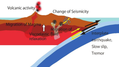
Beneath Japan, the Pacific and Philippine Sea Plates subduct beneath the continental plate. Stress in the Japanese island arc is controlled by plate convergence. Large plate-boundary earthquakes have caused severe disasters. We aimed to determine the coupling state at the plate boundaries, which is useful for evaluating the risk of plate boundary earthquakes. The geofluid was dehydrated using the subducting oceanic plate in the subduction zone. The dehydrated water decreases the strength of the fault. This phenomenon is related to inland earthquakes. To understand the risk of earthquakes, the entire subduction zone system must be understood (Fig. 1). In Japan, a scientific project dubbed “Second Earthquake and Volcano Hazards Observation and Research Program,” which was supported by the Ministry of Education, Culture, Sports, Science and Technology (MEXT) of Japan, was conducted during 2019–2023. The Earthquake Phenomena Research Group is one of the research groups under the Second Earthquake and Volcano Hazards Observation and Research Program. This group has conducted research aimed at understanding earthquake phenomena. This study reviews the results of the research group. Images of earthquakes that have occurred in subduction areas of Japan have become clearer. Understanding the mechanisms of earthquakes in Japan will help to reduce the damage caused by earthquakes and volcanic eruptions.
These research groups have examined several thematic areas, including plate boundary earthquakes, intraplate earthquakes, earthquake source processes, and the physical properties of fault zones and mantle wedges. For plate boundary earthquakes, the study areas are divided into the southern part of the Kuril subduction zone, the Japan Trench, the Nankai Trough, and other subduction zones. In these areas, there are concerns regarding the occurrence of earthquakes in the near future. A large earthquake occurred in the Japan subduction zone on March 11, 2011, prompting numerous seismic observations. Several important characteristics related to the causes of earthquakes were identified. Observations and analyses of data from other subduction zones are essential for understanding the universal characteristics of subduction zones. This study reviews the progress made in understanding each research topic.

Fig. 1. Schematic of earthquakes and volcanoes at the subduction zone. This schematic illustrates key processes relevant to earthquake generation. To predict the cycle of large megathrust plate boundary earthquakes, previous earthquake cycles must be examined. The coupling condition at the plate boundary is important for understanding these cycles. Laboratory experiments using sampled materials could provide information on the physical properties at the plate boundary. The occurrence of earthquakes caused by the fault is related to the stress distribution and slip strength of the fault. The close relationship between crustal fluids and strength of the fault has been investigated in numerous studies. The results of these studies help elucidate the occurrence of earthquakes.
2. Plate Boundary Earthquakes
2.1. Southern Part of the Kuril Subduction Zone
In Japan, the Pacific Plate subducts beneath the continental plate from east to west. The Philippine Sea Plate subducts in a northwesterly direction. Numerous megathrust earthquakes have repeatedly occurred along these trenches. The geometries of the subducting plates beneath Japan are complex. Large-scale earthquakes with long trench intervals, for which we have minimal knowledge owing to their low frequency, have caused severe damage. The southern Kuril subduction zone is expected to experience a large plate boundary earthquake in the future. Numerous large earthquakes have occurred along these trenches, including the 1963 Etorofu earthquake (Mw 8.5), the 1969 Kuril earthquake (Mw 8.2), the 1973 Nemuro-Oki earthquake (Mw 7.8), the 1952 Tokachi-Oki earthquake (Mw 8.1), and the 2003 Tokachi-Oki earthquake (Mw 8.3). This area is considered to be at high risk of future major earthquakes.
To understand the state of the earthquake occurrence cycle, it is necessary to understand the coupling state between the subducting and overriding plates at the plate boundary. Geodetic data obtained from the seafloor are valuable in this regard. GNSS-A, an underwater positioning system that combines the Global Navigation Satellite System (GNSS) and acoustic data transmission, is a good method for measuring displacement at the seafloor. Although the southern part of the Kuril subduction zone is considered a high-risk area for future major earthquakes, there have been no geodetic observations of the seafloor in this region. The lack of geodetic data prevents us from determining the current stage of the earthquake cycle. To address this gap, the research group applied GNSS-A to this area and geodetic data were successfully obtained 1. Three GNSS-A stations were established along the subduction direction—two on the back-arc side of the Japan Trench, and one on the forearc side. A theoretical simulation was also conducted. The simulation results suggest that a comparison of the theoretical and observed data made it possible to understand the coupling depth at the plate boundary. However, these data were insufficient to determine the coupling depth. In the near future, the accumulated data will enable the determination of the coupling depth in subduction zones. This knowledge is important for simulation analyses to determine the occurrence cycles of large plate boundary earthquakes. Frequent observation and low-error data are required to obtain accurate seafloor displacement measurements. Improvements in measurement methods have been studied. The observed data’s quality has also improved 2.
2.2. Japan Trench
Large earthquakes have also occurred in the Japan Trench, many of which have caused significant damage. In 1968, the Tokachi-Oki earthquake (Mw 8.3) occurred off the coast of Aomori Prefecture. Other earthquakes that occurred in the Japan Trench were the 1994 offshore Sanriku Earthquake (Mw 7.8), the 1978 Miyagi-Oki Earthquake (Mw 7.5), the 1938 Fukushima-Oki earthquake swarm (Mw 7.6–7.8), and the 1896 Sanriku-Oki Earthquake (Mw 8.1). The 2011 Tohoku-Oki Earthquake (M 9.0) occurred in the Japan Trench on March 11, 2011. Large displacements were observed at several GNSS stations in Japan. Given the magnitude of the Tohoku-Oki earthquake, GNSS and GNSS-A analyses indicated large displacements 3,4. A maximum horizontal displacement of 5.3 m was observed on the east coast of northeastern Japan 3. However, in the ocean, a large displacement was observed using GNSS-A 4. The co-seismic displacements of 5–24 m toward the ESE were estimated using GNSS-A measurements before and after the event. Results were obtained immediately after the earthquake.
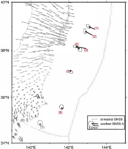
Fig. 2. Horizontal seafloor movements along the Japan Trench. The observed data were recorded over four years (Aug. 2018–Sep. 2022). This figure was adapted from a previous study 5.
Geodetic observations continued along the Japan Trench after the earthquake. High data accuracy is necessary for detailed interpretation. Accumulated GNSS-A data from August 2018 to September 2022 suggest regional variations along the Japan Trench 5 (Fig. 2). The accuracy of measurements using the GNSS-A system was a key challenge in this study. The observation frequency was increased to obtain more accurate values. The Wave Glider system allowed for more frequent data measurements. It was possible to detect regional variations and changes along the Japan Trench. The horizontal displacement results show that the spatial patterns change over time. The distribution of horizontal displacement velocities along the Japan Trench indicates that landward displacement due to viscoelastic relaxation continues to dominate the central part, whereas the spatial pattern of post-seismic deformation after the Tohoku-Oki earthquake changes over time in the northern section. Spatially dense geodetic stations with frequent data collection will be useful for monitoring the state of coupling at plate boundaries. These characteristics are helpful in understanding earthquake mechanisms. This research group conducted seismic observations using pop-up ocean-bottom seismometers (OBSs). Seismometers were used to detect tectonic tremors in the northern periphery of the aftershock area of the 2011 Tohoku-Oki earthquake 6. The detected tremors occurred near a sequence of small repeating earthquakes, indicating a mixed distribution of tremors and regular interplate earthquakes in the region. However, the close relationship between large plate-boundary earthquakes and tremors remains unclear. Further studies of tremors are required to clarify this relationship.
Data on earthquake mechanisms are required to determine the stress field in the research area. Centroid moment tensor (CMT) inversion analysis is useful for solving this problem. However, as the research area along the Japan Trench is far from land, performing such an analysis is difficult. The CMT inversion analysis was performed using data from an OBS 7. Specifically, a CMT inversion analysis was performed for small to moderate earthquakes using a dense short-period OBS array off Ibaraki Prefecture. This study demonstrates that CMT analysis is possible when high-spatial-density OBS arrays are used. In total, 536 CMT solutions were obtained. Regional variations in the CMT solutions have also been suggested.
Recently, distributed acoustic sensing (DAS) measurements utilizing optical fibers as sensors have become popular in various fields and have been applied to seismic observations. Few studies have been conducted using optical fiber cables in the oceans. In this study, DAS measurements were analyzed using a seafloor cable 8,9. The shortest spatial sampling of the DAS observations allowed the dense seismic observations to form a linear array. DAS measurements using seafloor cables are advantageous, because the amount of available data can be significantly increased in marine areas. In this study, data from the DAS measurements were compared with those obtained using a seismometer 8. No study has compared data from optical fibers and OBSs in the same area. Therefore, this study makes an important contribution by confirming the reliability of optical fiber data.
In seismic seafloor observations, the seismic structure of soft sediment is important because the seismic velocity of the layer changes based on the water in the layer. The S-wave velocity (Vs) structure of the sediments and uppermost crust on the landward slope of a subduction zone, which determines the dynamics of the overriding plate, provides significant data for this study. Seismic interferometry using DAS data was performed to image the sedimentary and crustal structures offshore Tohoku, Japan 9. A two-dimensional Vs structure was created along the cable, suggesting that the application of frequency–wavenumber filtering and seismic interferometry to marine DAS data can estimate Vs and Vp/Vs structures.
Long-term continuous observations of seafloor pressure are effective in detecting vertical seafloor deformations. These are associated with transient tectonic phenomena, such as slow slip events (SSEs). Since the aseismic slip event before the 2011 Tohoku earthquake, several discoveries have been made regarding spontaneous SSEs and various other types of slow earthquakes along the Japan and Kuril Trenches 10. In this project, pressure data on the seafloor were recorded, and high-quality data were obtained. Observations were conducted off the coast of the Boso Peninsula using ocean-bottom pressure gauges. Analysis of the data showed that slow slip continued offshore of the Boso Peninsula.
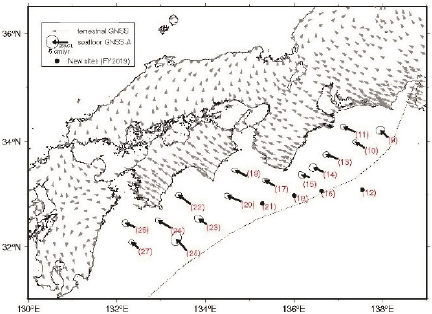
Fig. 3. Horizontal movements of the seafloor at the Nankai Trough for four years relative to the Amur plate. This figure was adapted from a previous study 11.
2.3. Nankai Trough
The Nankai Trough is a region in which major earthquakes have occurred repeatedly. The most recent major earthquakes in the Nankai Trough were the 1944 Tonankai (M 7.9) and the 1946 Nankai (M 8.0) earthquakes. Therefore, disaster mitigation measures should be considered for the next large earthquake in the Nankai Trough. In this regard, it is necessary to determine the coupling state at the plate boundary. Crustal deformation observations have been conducted regularly on the seafloor around the Japan Trench and Nankai Trough using GNSS-A (Fig. 3) 11,12. GNSS-A data were obtained prior to this project, allowing for an accurate understanding of the coupling between plates. The observation results were regularly reported at meetings of the Headquarters for Earthquake Research Promotion, MEXT 11.
Synthetic simulation studies are necessary to understand the cycles of large earthquakes at plate boundaries. In synthetic simulations, the plate geometry configuration is important, and the receiver function method is an effective tool for obtaining these data. A receiver function study suggested an interesting relationship between tremor activity and slab geometry 13. The Moho boundary is unclear at the tip of the mantle wedge because of the influence of slab-derived fluids, which may be related to the tremors. However, more detailed studies are required to determine the sources of these tremors. Numerous seismic studies have been conducted to obtain clear images of the subducting Philippine Sea slab in the Nankai Trough 14,15. A 3D map of fault geometries at the plate boundary was constructed from seismic profiles 14. A structural anomaly was found and interpreted as a low-seismic velocity zone in the overriding plate at the boundary between the zone of large coseismic slip during the 1946 Nankai earthquake and the area that produced slow earthquakes. This anomaly may be related to variations in the plate boundary fault slip.
The estimation of heat flow can contribute to an understanding of geological structures in plate convergence areas. Heat flow values in the accretionary wedge of the Nankai Trough off the Kii Peninsula, Japan, were calculated 16, and anomalies were found to be indicators of active faulting, corresponding to low-seismic velocity zones along the faults. Several geophysical datasets were used to obtain images of fault zones of megathrust earthquakes in the Nankai Trough.
2.4. Other Subduction Zones
To comprehensively understand plate boundary earthquakes, it is necessary to conduct research on various subduction zones, extract common characteristics, and clarify universal properties. Seismic studies have been conducted in several subduction zones. In particular, the relationship between slow earthquakes and variations in frictional properties with depth and interplate coupling has been considered. In the Nansei Islands region, where many islands are distributed from southern Kyushu to northeastern Taiwan, seismic observations of the oceanic area have been conducted because of the lack of land just above the subduction zone. Seismic observations using the OBS have been conducted in the plate boundary area of the northern Nansei Islands 17,18. Hyuga-nada, off the Pacific coast of Kyushu along the Nankai Trough in southwestern Japan, is one of the most active slow-earthquake regions in Japan. The region has also experienced significant seismic activity, which several studies have investigated. Shallow tremors and normal micro-earthquakes have been studied 17,18,19,20. Seismic observations of the seafloor in the Hyuga-nada region, located at the western end of the Nankai Trough, were performed to characterize shallow low-frequency tremor activity 17. The frequency of shallow tremors in the region was lower than that of deep tremors in the Nankai Trough, and major activities involving migration occur only once every two or more years. In contrast, minor activities lasting a few days occur several times per year. Major activities in 2015 were accompanied by migration, similar to those in 2013. The tremors in 2013 were characterized by a south-to-north migration at 30–60 km/d. However, the tremors in 2015 were characterized by a west-to-east migration, and the activity area extended further to the east. Migration rates were also markedly slower (up to 20 km/d) than those in 2013. These different migration properties likely reflect the state of interplate coupling on the down-dip side of shallow slow earthquake areas.
The energies of shallow tremors and moments of shallow very low-frequency earthquakes (VLFEs) in Hyuga-nada were estimated using data from a permanent onshore broadband network and temporary OBS observations 19. The energies and moments of these slow earthquakes exhibited similar along-strike variations. These values are generally higher south of the subducted Kyushu–Palau Ridge than near the top of the ridge. This spatial variation is also related to the characteristics of slow earthquake migration. The along-strike migration speed was faster at initiation in the south. For a more quantitative discussion of slow earthquake activity, the detection limits of the VLFE were investigated. Slow seismic earthquakes observed in low-frequency bands (\(<0.05\) Hz) have been evaluated in the Nankai Subduction Zone 20.
During this period, numerous seismic observations were made in other countries (e.g., 21,22,23,24). Seismic observations were also recorded in Mexico 21. The triggering of large earthquakes on a fault hosting aseismic slip and the triggering of SSE by passing seismic waves are useful for understanding the behavior of events at plate boundaries. The three devastating earthquakes in Guerrero and Oaxaca, Mexico, were likely related to SSEs. The discovery of episodic shallow tremors and potential SSEs offshore Guerrero has been reported. Their distribution, together with those of repeated earthquakes, seismicity, residual gravity, and bathymetry, suggests that a portion of the shallow plate interface in the gap underwent a stable slip.
Seismic observational studies using OBS were conducted in the New Zealand subduction zone 22,23,24. Using OBS along the northern Hikurangi subduction zone, New Zealand, the locations of 2005 earthquakes (M 0.7–4.5) and detailed 3-D Vp and Vs models were obtained 22. Analysis over a \(120 \times 110\) km\(^2\) area revealed a high Vp/Vs (\(>1.8\)) in the subducting 10-km-thick Hikurangi Plateau oceanic crust below an area of repeating SSEs. Low Vp/Vs was mapped in a 15-km-wide domain along the coastline offshore of Gisborne. Seismic observational research on subduction zones worldwide is advancing our understanding of subduction zone systems.
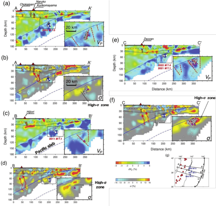
Fig. 4. Trench-normal vertical cross-sections of tomographic images. (a) Vp tomography along profile A–A\('\). The red triangles and the thick black line at the top show active volcanoes and the land area, respectively. The orange dots under the volcanoes show low-frequency microearthquakes (M 0.0–2.0) within a 30-km-wide profile. The dashed and solid black lines denote the Conrad and Moho discontinuities, respectively. The solid and dashed blue lines denote the slab’s upper and lower boundaries, respectively. The vicinity of the intraslab earthquakes (the black rectangle) is scaled up and shown beside the panel. The dashed red lines denote estimated hydrated faults. The blue focal mechanism plots show fault-plane solutions of the four large intraslab earthquakes (M \(\ge 7.0\)). (b) Similar to (a) but for Poisson’s ratio (\(\sigma\)) image along profile A–A\('\). The red arrows show the migration paths of fluids released from slab dehydration. (c) and (d) are the same as (a) and (b) but along profile B–B\('\). (e) and (f) are the same as (a) and (b) but along profile C–C\('\). The locations of the three profiles are shown in (g). The red and white dots in (a)–(f) denote relocated hypocenters of the mainshock and aftershocks (in the two months following the mainshock) of the 2022 Fukushima-Oki earthquake (Mj 7.4), respectively, whereas the red and white triangles denote relocated hypocenters of the mainshocks and corresponding aftershocks, respectively, of the other three large intraslab events. The Vp and \(\sigma\) perturbation scales are shown below (f). This figure is adapted from Fig. 4 of Wang et al. 25.
3. Intraplate Earthquakes
3.1. Intraslab Earthquakes
Intraslab earthquakes can cause large disasters. For instance, the 1933 Sanriku earthquake (Mw 8.4) was an intraslab earthquake that occurred off the coast of Sanriku in northeastern Japan. This earthquake caused a large tsunami, which killed over 3,000 people. Several other large intraslab earthquakes have also occurred in Japan. The 1993 Kushiro-Oki earthquake (Mw 7.6) and 1994 Kuril Islands earthquake (Mw 8.3) were also intraslab earthquakes. Owing to their depth and magnitude, intraslab earthquakes can also cause disasters. Several seismic studies have been conducted to elucidate the source mechanisms of this type of earthquake. The source areas of intraslab earthquakes have also been investigated. However, the resolution of the data was insufficient to explain the cause of intraslab earthquakes. Recently, a clear image of the source areas of intraslab earthquakes was obtained from the accumulation of seismic data. The relationship between the seismic structure of the slab and intraslab sources area was investigated 25. Fine 3D seismic velocity structures of the source area of four large intraslab earthquakes ( \(\textrm{M} \ge 7.0\)) in northeast Japan, including the March 16, 2022 Fukushima-Oki earthquake (M 7.4), were obtained 25 (Fig. 4). The four intraslab events were located in a local zone with a high Poisson’s ratio down to a depth of approximately 20 km below the upper surface of the slab. A zone with a high Poisson’s ratio was considered to reflect water enrichment. The four large intraslab events were thought to be associated with the reactivation of buried hydrated faults formed during the outer rise in the subduction process. Dehydration embrittlement can control the occurrence of large intra-slab earthquakes.
Some intra-slab earthquake faults were created in the slab when it was located on the seafloor. Cracks on the seafloor surface are a key cause of intraplate earthquakes; thus, topography and faults on the seafloor have been thoroughly studied 26,27,28. The upper boundary of the subducting oceanic plate is not smooth. Several fractures and faults were observed. The detailed structure of the interface, which is composed of fractures and faults, and the physical properties at the interface provide informative data for understanding the causes of intraslab earthquakes.
3.2. Inland Earthquakes
Inland earthquakes caused by active faults can cause serious disasters because the source faults can be located very close to populated areas. The causes of inland earthquakes were also investigated, revealing that they are caused by the accumulation of strain and concentration of stress on faults. Earthquakes occur when the stress exceeds the fault strength limit. Therefore, we must consider the following points: (1) What controls fault strength? (2) Why do stress concentration and strain accumulation occur?
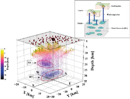
Fig. 5. Distribution of reflection points and inset figure. The reflection points were obtained using Reverse Vertical Seismic Profiling (VSP) analysis. VSP is a method of clarifying the underground structure by setting up observation points in a borehole and transmitting seismic waves from the surface to obtain elastic wave records in the vertical direction. Reverse VSP analysis clarifies vertical subsurface structure by deploying many observation points on the surface, taking advantage of the fact that the distribution of the hypocenters of each earthquake varies in depth. Yellow stars indicate earthquakes used for Reverse VSP analysis. Reflection points obtained using the analysis are color-coded according to the depth. Two broken red lines indicate the approximate locations of S-wave reflection boundaries, R1 and R2. This figure is modified from Figs. 10 and 13 in Usuda et al. 31.
Several seismic studies have been conducted to determine the causes of inland earthquakes. Seismic structures in fault zones have also been studied 29. It has been suggested that a low-seismic-velocity zone is located below the fault. This is a common feature of fault zones where earthquakes occur. The resistivity structure was also investigated. Low-seismic-velocity zones are characterized by low resistivity. It has been suggested that geofluids exist below the fault zone. Recently, it has also been considered that low-seismic and low-resistivity zones are evidence that the fluid is located just below the fault zone. Crustal fluids are also considered to be related to inland earthquakes. Geofluids weaken the strength of the fault, resulting in earthquakes. During this five-year research period, studies on the source faults of inland earthquakes increased. A relationship between faults and low-seismic velocity and low-resistivity areas has also been suggested 30,31,32,33,34,35,36. The characteristics of the lower crust are related to fault weakening. The anelastic strain rate in the lower crust and interplate coupling rate were investigated via inversion analysis using GNSS data to elucidate seismotectonics 30. The rate suggests the existence of a shear zone consisting of weak faults in the Beppu-Shimabara graben, Kyushu. It has been suggested that stress concentration is related to the deformation of the lower crust. A close relationship between the location of the fault and the lower crust structure has also been suggested.
The Fukushima-Hamadori earthquake (Mj 7.0) occurred in south-northeastern Japan approximately one month after the 2011 Tohoku-Oki earthquake. A seismic array was deployed in this area, and two phases were observed. The latter phases were interpreted as reflected waves at the boundaries at depths of 15–23 and 26–34 km beneath the source fault 31. These were the crustal and Moho boundaries, respectively. The crustal boundary was considered to have been formed by crustal fluid because the amplitude of the observed wave was large. Seismic activity may have been caused by crustal fluids in the Iwaki area (Fig. 5). Crustal reflectors, caused by crustal fluid, are related to the source fault of inland earthquakes.
The seismicity of crustal earthquakes has changed since the 2011 Tohoku-Oki earthquake, according to data analyzed for several regions in central Tohoku, Japan 32. A clear migration of seismic activity from deeper to shallower regions has been previously reported. The seismicity was thought to have been caused by a decrease in fault strength due to the rise in crustal fluids. Several studies support the idea that crustal earthquakes are caused by crustal fluids 29,31,32. The physical parameters along source faults were also examined, further confirming the close relationship between crustal fluids and fault ruptures 33. The focal area of the 2016 Kumamoto earthquake (Mw 7.0) was investigated using 200 broadband magnetotelluric stations. The relationship between the magnetotelluric structure and rupture processes of an earthquake is important for the initiation, growth, and arrest of the rupture (Fig. 6). The ruptures were arrested by high-temperature fluid-rich zones, which were higher than 400°C, whereas shallower low-temperature (200°C–400°C) fluid-rich zones either promoted or arrested the ruptures. It has been suggested that the distribution of midcrustal fluids contributes to the initiation, growth, and arrest of crustal earthquakes. Moreover, inland earthquakes are thought to be caused by crustal fluids. The results of this study provide strong evidence that inland earthquakes are caused by crustal fluids. The next step is to determine the fluid supply source and amount of crustal fluid transported. These results provide important information for understanding the potential occurrence of inland earthquakes.
The relationship between the seismic structure and the source faults of large earthquakes has also been revealed. The concentration of stress and accumulation of strain on the source fault are also important for understanding earthquake mechanisms. Many small aftershocks occur following a large earthquake. In addition, large earthquakes do not typically occur near fault edges. Highly accurate focal mechanism solutions for the aftershocks of the 2016 Central Tottori earthquake (Mw 6.2) were investigated 34. Aftershocks rarely occur near the horizontal edges or extensions of the fault. The mainshock rupture was arrested within areas characterized by substantial stress relaxation. This stress relaxation along the fault edges could explain why mainshocks were rarely followed by large earthquakes.
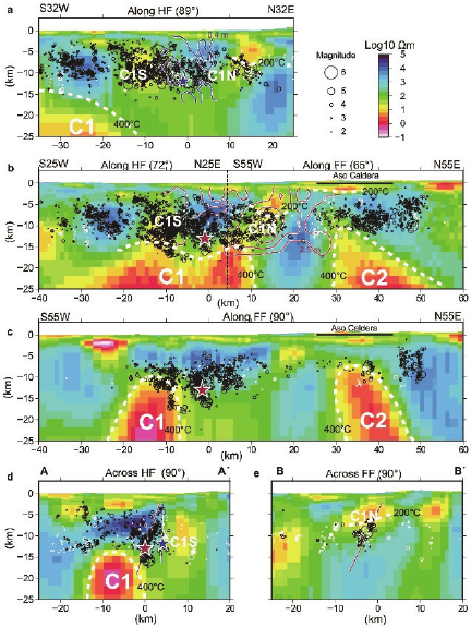
Fig. 6. Dipping and vertical slices of the electrical resistivity structure and seismicity along and across the faults. The hypocenters within 2 km of each slice are plotted on the resistivity profiles. (a) Near-vertical slice along Hinagu Fault, which slipped during the Mw 6.2 foreshock. Blue stars and contours indicate the foreshock hypocenter and spatial slip distribution on the fault plane (0.3-m contour interval), respectively. (b) Northward and westward-dipping slices along the mainshock fault planes. The mainshock rupture propagated along the Futagawa and Hinagu Faults; these two fault planes merged at the location of the vertical dashed line. Red stars and contours indicate the mainshock hypocenter and spatial slip distribution on the fault plane, respectively. Dashed white lines show the inferred 200°C and 400°C isotherms, which correspond to the base of the altered clay (smectite) layer and brittle–ductile transition zone, respectively. (c) Vertical slice along the Futagawa Fault. (d) Vertical slice across the foreshock and mainshock hypocenters. (e) Vertical slice across the midpoint of Futagawa Fault, where the largest slip due to the mainshock is estimated. This figure is adapted from Fig. 3 of Aizawa et al. 33.
To elucidate how the sizes of these earthquakes were determined, the aftershocks of the 2016 Central Tottori earthquake (Mw 6.2) and the 2000 Western Tottori earthquake (Mw 6.7) were investigated. The stress field estimated from the focal mechanisms of aftershocks was compared with the calculated post-earthquake stress field. The differential stress before the earthquake was very low near both horizontal edges. These results suggest that the fault size of large intraplate earthquakes can be determined by the region of small differential stress surrounding the future earthquake faults.
A large earthquake (Mw 7.5) occurred on the Noto Peninsula in central Japan on January 1, 2024. On the Noto Peninsula, an Mw 6.2 earthquake occurred on May 5, 2023. Analysis of the event in 2023 revealed systematic upward migration of seismicity through a complex fault network during the preceding swarm period. The mainshock rupture was initiated near the shallower part of the swarm earthquakes, propagated in an updip direction, followed by many aftershocks in a shallow extension. The systematic upward earthquake migration at depths of 5–18 km can be explained by the upward fluid movement 36.
4. Source Process
Understanding rupture propagation is important for understanding source processes. Asperity behavior is a key factor controlling rupture propagation, and the asperities of source faults have been extensively studied 37. The source processes of eight large earthquakes with magnitudes greater than 7 that occurred after 1930 in northeastern Japan were investigated. An asperity map of the subducting plate along the Japan Trench was obtained, and several asperity characteristics were identified: (1) the location was fixed in space; (2) asperities tended to be located away from the initial break; and (3) the aftershock activity was rather low in the asperity. It was assumed that earthquakes of the same size would occur repeatedly because the location was fixed in space. Before the 2011 Tohoku-Oki earthquake, this concept was considered a universal asperity characteristic. However, the source of the 2011 Tohoku-Oki earthquake was complex. While more complex characteristics have been proposed, it was difficult to explain the rupture process based on previous studies. The source fault asperity was modified by considering the asperity characteristics 38. All large earthquakes start from a point and spread over hundreds of kilometers. Whether the growth process of the rupture of a large earthquake is predictable and whether it produces observable signatures different from those of smaller events are fundamental questions. The large and small events occurred close to each other. The frequent similarities between subduction earthquakes of different magnitudes suggest repeated cascading rupture processes over a widespread hierarchy along the plate boundaries (Fig. 7). Research on asperities is necessary to determine the magnitude of earthquakes.
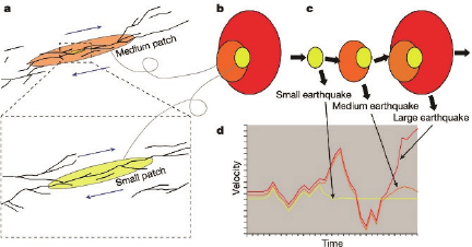
Fig. 7. Schematic of a hierarchical structure that produces almost identical initial waveforms, regardless of the size of the earthquake. (a) Generalized fault system with a complex and nested geometrical heterogeneity. Parts of the fault can be simplified at various scales. (b) Simplified image of a complex fault system with three nested patches. (c) Illustration of the cascading rupture of a hierarchical patch. (d) Typical seismic waveforms from small, medium, and large earthquakes occurring on the hierarchical structure. This figure was adapted from Fig. 4 of Ide 38.
5. Physical Properties of Fault Zones and Mantle Wedge
Studies have been conducted using seismic observations to determine the characteristics of fault rupture processes. However, the physical behavior of the materials in the geological layers and fault boundaries must be identified to understand the rupture process of the fault based on physical processes. Knowledge of the physical properties of plate boundaries and fault zones is important for understanding rupture processes 39,40,41. Fluid–rock interactions within accretionary prisms drastically change the frictional strength and slip stability of fault zones. To understand the effect of the ultramafic components on the degree of interplate coupling, data on the frictional properties of the reaction zone between serpentinite and argillite in a tectonic mélange were collected 39. Si-metasomatism along the argillite–serpentinite contact reduced friction and stabilized slip, forming frictionally weak velocity-strengthening regions in the megathrust zone. This information is important for understanding the behavior of fault planes.
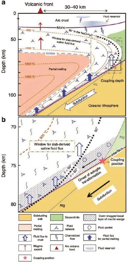
Fig. 8. Schematic model of migration of saline aqueous fluids. (a) Overview of subduction fluid migration. (b) Enlargement of the black rectangle in (a). Slab-derived saline fluids can form an interconnected network in the mantle wedge at depths of approximately 80 km and can percolate partly through the overriding mantle without causing melting or serpentinization to form a fluid reservoir in the forearc crust. This figure was adapted from Fig. 7 of Huang et al. 42.
This suggests that the fluids affect fault strength. Therefore, the behavior of water in mantle wedges must be considered 42. The results showed that the slab-released fluid formed an interconnected network at a relatively shallow depth of approximately 80 km and could partly reach the forearc crust without causing wet melting or serpentinization of the mantle. Fluid transport through this permeable window of the mantle wedge accounts for the high electrical conductivity anomalies detected in the forearc regions (Fig. 8).
Several studies have been conducted to understand earthquake mechanisms. This accumulated knowledge is valuable for understanding the entire earthquake phenomena and is saved in a database accessible to multiple researchers. A geophysical database is important for understanding these phenomena, therefore, several databases on this topic have been published 43. A crustal stress map of Japan was published in the crustal stress field database 43, which collects available data on crustal stress in Japan, primarily measured and observed for earthquake research as well as for various functions. Geophysical data will be useful for improving many researchers’ studies.
6. Summary
Recently, several earthquakes have occurred in Japan, which have caused large-scale disasters. This study aimed to understand the mechanisms by which earthquake disasters can be mitigated. Earthquakes that have occurred around Japan include plate boundary, intraplate, and inland earthquakes.
Knowledge of the coupling state at the plate boundary is important for understanding the cycle of large plate boundary earthquakes. A geodetic study using GNSS-A was conducted in the Kuril area to obtain important data for this project. Geodetic data were obtained from regular observations in the Japan Trench and Nankai Trough areas. To obtain highly accurate data, it is important to increase the observation frequency. The data acquired through this project, along with the technology advanced, have made a significant contribution to obtaining accurate data. Research on the subduction of the Nansei Islands, Mexico, and the Hikurangi subduction zone, New Zealand, has been conducted to gain a universal understanding of these subduction zones.
Knowledge of the mechanisms of intraslab earthquakes has improved, revealing that the crack structure within the plate was closely related to the cause of intraplate earthquakes. A close relationship between the structure and the source mechanisms of intraslab earthquakes has also been suggested.
Research on the relationship between earthquakes and geofluids has significantly progressed. Many studies of inland earthquakes in this project support the idea that earthquakes are caused by crustal fluids. The relationship between inland earthquakes and the crustal boundary, which is a layer of crustal fluid, provides clear evidence that the fluids were related to the cause of the inland earthquake. However, most previous studies have been qualitative, which are important as the next step.
Experimental studies on plate boundary earthquakes have been conducted to understand the physical processes occurring at plate boundaries, which have elucidated the behavior of rocks at plate boundaries. The research scales of the data obtained from experimental studies in laboratories and seismic observations at plate boundaries are different. Therefore, knowledge that combines experimental and observational data is important for advancing our understanding of earthquake rupture processes. Finally, the acknowledgement that databases of observed geophysical data are important for understanding earthquakes has led to their improvement and publication.
Acknowledgments
This study was supported by the Ministry of Education, Culture, Sports, Science and Technology (MEXT) of Japan under the Second Earthquake and Volcano Hazards Observation and Research Program (Earthquake and Volcano Hazard Reduction Research). We express our sincere gratitude to the two anonymous reviewers who carefully checked the manuscript.
- [1] F. Tomita, M. Kido, T. Iinuma, Y. Ohta, R. Hino, M. Ohzono, H. Takahashi, R. Plata-Martínez, T. No, K. Nakahigashi, and K. Nakamura, “GNSS-Acoustic seafloor geodetic observations and their results along the Japan-Kuril trench,” Abstract of the Fall Meeting of Seismological Society of Japan, Article No.S03-05, 2023 (in Japanese).
- [2] F. Tomita and M. Kido, “An approximate travel time calculation and a robust GNSS-acoustic positioning method using an MCMC technique,” Earth Planets Space, Vol.74, Article No.176, 2022. https://doi.org/10.1186/s40623-022-01740-0
- [3] S. Ozawa, T. Nishimura, H. Suito, T. Kobayashi, M. Tobita, and T. Imakiire, “Coseismic and postseismic slip of the 2011 magnitude-9 Tohoku-Oki earthquake,” Nature, Vol.475, Issue 7356, pp.373-376, 2011. https://doi.org/10.1038/nature10227
- [4] M. Sato, T. Ishikawa, N. Ujihara, S. Yoshida, M. Fujita, M. Mochizuki, and A. Asada, “Displacement above the hypocenter of the 2011 Tohoku-Oki Earthquake,” Science, Vol.332, Issue 6036 Article No.1207401, 2011. https://doi.org/10.1126/science.1207401
- [5] https://cais.gsi.go.jp/YOCHIREN/report/kaihou109/03_03.pdf [Accessed November 18, 2024]
- [6] H. Takahashi, R. Hino, N. Uchida, T. Matsuzawa, Y. Ohta, S. Suzuki, and M. Shinohara, “Tectonic tremors immediately after the 2011 Tohoku-Oki earthquake detected by near-trench seafloor seismic observations,” Prog. Earth Planet. Sci., Vol.9, No.1, Article No.66, 2022. https://doi.org/10.1186/s40645-022-00525-z
- [7] L. Yamaya, K. Mochizuki, T. Akuhara, S. Takemura, M. Shinohara, and T. Yamada, “CMT inversion for small-to-moderate earthquakes applying to dense short-period OBS array at off Ibaraki region,” Earth Planets Space, Vol.74, Article No.164, 2022. https://doi.org/10.1186/s40623-022-01721-3
- [8] M. Shinohara, T. Yamada, T. Akuhara, K. Mochizuki, and S. Sakai, “Performance of seismic observation by distributed acoustic sensing technology using a seafloor cable off Sanriku, Japan,” Front. Mar. Sci., Vol.9, Article No.844506, 2022. https://doi.org/10.3389/fmars.2022.844506
- [9] S. Fukushima, M. Shinohara, K. Nishida, A. Takeo, T. Yamada, and K. Yomogida, “Detailed S-wave velocity structure of sediment and crust off Sanriku, Japan by a new analysis method for distributed acoustic sensing data using a seafloor cable and seismic interferometry,” Earth Planets Space, Vol.74, Article No.92, 2022. https://doi.org/10.1186/s40623-022-01652-z
- [10] R. Hino, T. Kubota, N. Y. Chikasada, Y. Ohta, and H. Otsuka, “Assessment of S-net seafloor pressure data quality in view of seafloor geodesy,” Prog. Earth Planet. Sci., Vol.9, Article No.73, 2022. https://doi.org/10.1186/s40645-022-00526-y
- [11] https://cais.gsi.go.jp/YOCHIREN/report/kaihou109/08_05.pdf [Accessed November 18, 2024]
- [12] S. Watanabe, T. Ishikawa, Y. Nakamura, and Y. Yokota, “Full-Bayes GNSS-A solution for precise seafloor positioning with single uniform sound speed gradient layer assumption,” J. Geod., Vol.97, Article No.89, 2023. https://doi.org/10.1007/s00190-023-01774-6
- [13] T. Shibutani, M. Teraishi, S. Komatsu, K. Yamazaki, Y. Yamashita, T. Ohkura, S. Yoshikawa, M. Iguchi, T. Tameguri, and T. Sonoda, “Estimation of the structure of the Philippine Sea Slab and its surrounding area beneath southern Kyushu by seismological methods,” DPRI Annu., Vol.62-B, pp. 280-287, 2019.
- [14] Y. Nakamura et al., “Structural anomaly at the boundary between strong and weak plate coupling in the central-western Nankai Trough,” Geophys. Res. Lett., Vol.49, Issue 10, Article No.e2022GL098180, 2022. https://doi.org/10.1029/2022GL098180
- [15] K. Shiraishi et al., “Seismogenic zone structures revealed by improved 3-D seismic images in the Nankai Trough off Kumano,” Geochem. Geophys. Geosyst., Vol.20, pp. 2252-2271, 2019. https://doi.org/10.1029/2018GC008173
- [16] S. Takenouchi et al., “Identification of active faults and tectonic features through heat flow distribution in the Nankai Trough, Japan,” Earth Planets Space, Vol.75, Article No.147, 2023. https://doi.org/10.1186/s40623-023-01890-9
- [17] Y. Yamashita et al., “Shallow tectonic tremor activities in Hyuga-nada,” Earth Planets Space, Vol.73, Article No.196, 2021. https://doi.org/10.1186/s40623-021-01533-x
- [18] T. Akuhara et al., “Shallow low-velocity layer in the Hyuga-Nada accretionary prism,” J. Geophys. Res. Solid Earth, Vol.128, Issue 4, Article No.e2022JB026298, 2023. https://doi.org/10.1029/2022JB026298
- [19] S. Baba et al., “Spatial variation in shallow slow earthquake activity in Hyuga-nada,” Geophys. J. Int., Vol.237, pp. 271-287, 2024. https://doi.org/10.1093/gji/ggae039
- [20] S. Takemura et al., “Detectability analysis of very low frequency earthquakes,” Geophys. J. Int., Vol.237, pp. 49-63, 2024. https://doi.org/10.1093/gji/ggae033
- [21] V. M. Cruz-Atienza et al., “Short-term interaction between silent and devastating earthquakes in Mexico,” Nat. Commun., Vol.12, pp. 49-63, 2021. https://doi.org/10.1038/s41467-021-22326-6
- [22] K. Mochizuki et al., “Seismicity and velocity structure in the vicinity of repeating slow slip earthquakes,” Earth Planet. Sci. Lett., Vol.563, Article No.116887, 2021. https://doi.org/10.1016/j.epsl.2021.116887
- [23] Y. Iwasaki et al., “Continuous tremor activity with stable polarization direction,” J. Geophys. Res. Solid Earth, Vol.127, Issue 2, Article No.e2021JB022161, 2022. https://doi.org/10.1029/2021JB022161
- [24] D. Bassett et al., “Crustal structure of the Hikurangi Margin from SHIRE seismic data,” Geophys. Res. Lett., Vol.49, Issue 2, Article No.e2021GL096960, 2022. https://doi.org/10.1029/2021GL096960
- [25] Z. W. Wang et al., “Fine structure of the subducting slab and the 2022 M7.4 Fukushima-Oki earthquake,” Seismol. Res. Lett., Vol.94, pp. 17-25, 2023. https://doi.org/10.1785/0220220234
- [26] E. Jamali Hondori et al., “Full-waveform inversion for imaging faulted structures,” Pure Appl. Geophys., Vol.178, pp. 1609-1630, 2021. https://doi.org/10.1007/s00024-021-02727-w
- [27] E. J. Hondori and J.-O. Park, “Connection between high pore-fluid pressure and frictional instability,” Sci. Rep., Vol.12, Article No.12556, 2022. https://doi.org/10.1038/s41598-022-16578-5
- [28] J.-O. Park et al., “Mantle-derived helium released through the Japan trench bend-faults,” Sci. Rep., Vol.11, Article No.12026, 2021. https://doi.org/10.1038/s41598-021-91523-6
- [29] A. Hasegawa et al., “Plate subduction and generation of earthquakes and magmas in Japan,” Gondwana Res., Vol.16, Issues 3-4, pp. 370-400, 2009. https://doi.org/10.1016/j.gr.2009.03.007
- [30] Y. Yuasa and S. Matsumoto, “Anelastic deformation in the lower crust,” Tectonophysics, Vol.846, Article No.229674, 2023. https://doi.org/10.1016/j.tecto.2022.229674
- [31] Y. Usuda et al., “Imaging of S wave reflection boundaries,” Zisin (J. Seismol. Soc. Jpn.), Vol.75, pp. 125-143, 2022 (in Japanese). https://doi.org/10.4294/zisin.2021-13
- [32] K. Yoshida, “Studies about the impacts of upward fluid migration,” Zisin (J. Seismol. Soc. Jpn.), Vol.74, pp. 95-116, 2021 (in Japanese). https://doi.org/10.4294/zisin.2020-20
- [33] K. Aizawa et al., “Electrical conductive fluid-rich zones,” Earth Planets Space, Vol.73, Article No.12, 2021. https://doi.org/10.1186/s40623-020-01340-w
- [34] Y. Iio et al., “Stress relaxation arrested the mainshock rupture,” Commun. Earth Environ., Vol.2, Issue 1, Article No.156 2021. https://doi.org/10.1038/s43247-021-00231-6
- [35] Y. Iio et al., “Spatial change in differential stress magnitudes,” Geophys. J. Int., Vol.233, pp. 1279-1295, 2023. https://doi.org/10.1093/gji/ggac521
- [36] K. Yoshida et al., “Updip fluid flow in the crust of the northeastern Noto peninsula,” Geophys. Res. Lett., Vol.50, Issue 21, Article No.e2023GL106023, 2023. https://doi.org/10.1029/2023GL106023
- [37] Y. Yamanaka and M. Kikuchi, “Asperity map along the subduction zone,” J. Geophys. Res. Solid Earth, Vol.109, Issue B7, Article No.B07307, 2004. https://doi.org/10.1029/2003JB002683
- [38] S. Ide, “Frequent observations of identical onsets of large and small earthquakes,” Nature, Vol.575, Isssue 7772, pp. 112-116, 2019. https://doi.org/10.1038/s41586-019-1508-5
- [39] K. Hirauchi et al., “The role of metasomatic alteration on frictional properties,” Earth Planet. Sci. Lett., Vol.531, Article No.115967, 2020. https://doi.org/10.1016/j.epsl.2019.115967
- [40] K. Hirauchi et al., “Cataclastic and crystal-plastic deformation,” Earth Planet. Sci. Lett., Vol.572, Article No.117232, 2021. https://doi.org/10.1016/j.epsl.2021.117232
- [41] M. Semba et al., “Effects of hydrothermal alteration on shear localization,” Tectonophysics, Vol.868, Article No.230081, 2023. https://doi.org/10.1016/j.tecto.2023.230081
- [42] Y. Huang et al., “Saline aqueous fluid circulation in mantle wedge,” Nat. Commun., Vol.10, Article No.5557, 2019. https://doi.org/10.1038/s41467-019-13513-7
- [43] Crustal stress field database. https://gbank.gsj.jp/crstress/ [Accessed November 28, 2025]
This article is published under a Creative Commons Attribution-NoDerivatives 4.0 Internationa License.