Paper:
Successive Estimation Model of Residential Flood Damage Based on Staged Acquisition of Field Information: Integration of Pre-Event Hazard Maps, Early Inundation Observations, and Roughly Identified Inundation Areas
Kazushiro Yoshimori† and Yuichiro Usuda
National Research Institute for Earth Science and Disaster Resilience (NIED)
3-1 Tennodai, Tsukuba, Ibaraki 305-0006, Japan
†Corresponding author

Immediately after a flood, actionable information emerges sequentially over several days, progressing from initial detection to early on-site observations and ultimately to broadly delineated inundation extents provided by responsible agencies. This study presents a three-phase model that updates estimates in step with this progression by integrating (i) pre-event inundation assumption areas (data of flood hazard area) prepared before disasters, (ii) on-site point observations of inundation depths or edges, and (iii) a roughly identified inundation area grasped on-site or from above by disaster response agencies such as municipalities, prefectures, and Geospatial Information Authority of Japan, obtained and shared over several days. Assuming a locally horizontal water surface, we infer water-surface elevations from point depths and propagate them to house-level depths, classifying above/below-floor with a 0.5 m threshold. With multiple points, we report Hmax/Hmin and Hb-max/Hb-min to express uncertainty. Applied to three districts in Nagano Prefecture affected by Typhoon Hagibis (2019), above-floor estimates in Phases 2–3 achieved ∼10% error in one district. Errors tended to increase in flat, high-density urban areas but were mitigated by sub-domain partitioning along levees and arterial roads. The framework successively updates estimates as datasets are obtained and shared by relevant agencies, supporting early, depth-indexed tasks such as resource allocation and damage recognition.
1. Introduction
1.1. Background
When a flood occurs, it causes diverse forms of damage, including inundation of residential buildings, loss of life and injury, and disruption to roads and critical lifeline infrastructure. Among these, residential inundation has particularly severe and immediate consequences for affected households: residents are often forced to dispose of unusable household goods, secure temporary housing, and undertake every kind of practical procedure to reconstruct their livelihoods. The concerned municipalities have to swiftly proceed with a wide range of responses, such as disposal of disaster waste, provision of emergency temporary housing, building damage assessment, issuance of victim certificates, and support for reconstructing livelihoods.
To enable early reconstruction of residents’ livelihoods, these responses must be carried out smoothly; thus, timely assessment of the extent of residential property damage in the initial stage of a flood is essential. The guidelines on disaster-related measures taken by the municipalities 1 list 17 items for disaster responses. Each item demands a response on the day of the disaster. Moreover, some responses such as the plan for building damage assessment and the plan for disposal of disaster waste require calculating the extent of residential property damage. Consequently, to formulate plans for each measure, it is important to grasp the extent of residential property damage on the day of a disaster. For example, Fujiwara et al. 2 indicate the importance in disaster response to formulate the response plan using the evaluation of the disaster response process by “the General Adviser for Disaster Management.” Concretely, in conducting the damage assessment, the extent of residential property damage should be estimated, and the necessary plan for personnel, goods, budget, time period, and other response elements should be formulated from the initial day of responses.
Several models have been proposed to determine the scale of responses based on the extent of damage. For example, the first model calculates the necessary workload of volunteers 3, the second one calculates the amount of disaster waste based on the inundation depth corresponding to the houses flooded above and below floor levels, respectively (hereafter, “inundation rank”) 4,5,6,7,8, the third one calculates the required number of emergency temporary housing units 9, and the fourth one concerns the building damage assessment 10. These models are proposed to concretize the plan for disaster response. However, these models do not prioritize acquiring information on the extent of damage at the right time. In other words, the methods are necessary to determine the extent of damage to acquire information on the extent of residential property damage at the timing necessary for the responses from the day of a disaster and apply this information to calculate the scale of responses.
According to “the Fire and Disaster Reporting Procedures” stipulated by the Fire and Disaster Management Agency, the extent of residential property damage shall be reported from municipalities to prefectures and then from prefectures to the Central Government 11. These procedures highlight the fact that it takes several days to several weeks in order to estimate the extent of residential property damage from the municipalities 12. Using the current methods relying on the report on the extent of residential property damage, the municipalities, the prefectures, and the Central Government cannot determine the extent of damage for the initial response and formulate a plan on time.
1.2. Previous Studies
Previous studies have proposed various models to estimate inundation area and inundation depth to quickly determine the extent of inundation damage after the occurrence of a disaster. For example, one model estimates inundation area using satellite images 13,14, one calculates inundation depth and inundation area from SNS and news images 15,16,17, and a third one quantitatively evaluates inundation depth from the state of submersion of the object, such as a car judged visually on-site 18,19. These studies primarily focus on the inundation phenomenon, similar to inundation area and inundation depth, and the accuracy of their estimation but not on the time taken for the estimation to be completed. No previous study has calculated residential property damage based on the estimated inundation area and inundation depth. Many previous studies show that it takes several days from the day of the disaster to achieve results because, for example, numerous observations of inundation depth are needed for the same. Such studies do not consider the successive update of the estimation by incorporating it on the day of the disaster and the partial information thereafter.
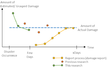
Fig. 1. Positioning of this study with respect to the process of evaluating flood damage. The green line shows this research, which updates estimates successively according to the progress of information acquisition—from immediate post-disaster to inundation areas shared by agencies over several days.
1.3. Objective of this Study
The study aims to construct a model to swiftly determine the extent of residential property damage at the time of river flood and the successive estimation corresponding to the information acquired in stages. The available information varies in a time series occurring immediately after a disaster. Only limited information on the flood occurrence point is available immediately after a disaster, and the information on inundation depth and inundation area is added over time. This study aims to use such available information successively, construct a method to estimate the extent of damage in stages, and calculate the damage cost to formulate the plan for initial response.
Especially, because it is necessary for the municipalities, the prefectures, and the Central Government supporting the municipalities to undertake the responses on the day of a disaster, we construct the model to estimate the extent of damage in order to successively update estimates as datasets are obtained and shared by relevant agencies over several days. By incorporating the information available before the disaster occurs and the information on inundation area and inundation depth acquired on-site, the authors focus on estimating residential property damage according to the inundation rank based on the information available successively. This method of estimation enables us to determine the extent of damage earlier than the previous process of the residential property damage report. Previous studies have estimated the damage only at one point of time, while this method estimates the damage in stages by using the information acquired successively (Fig. 1).
With this method, this study aims to estimate the scale of damage earlier and realize the effective responses to disaster based on the scale of damage.
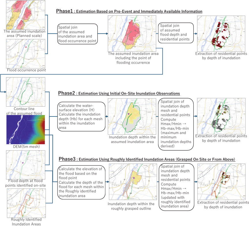
Fig. 2. Processing flow of model to estimate extent of residence inundation.
1.4. Study Methods
This study comprises the design of a disaster estimation model, its application to an actual disaster as a case, and the evaluation.
In Section 2, focusing on the changes in the information obtained immediately after the disaster, the model to estimate the damage in stages is designed using the information available successively in a time series. In Section 3, taking the case of Suzaka City and Nagano City, Nagano Prefecture, which suffered flood damage from Typhoon Hagibis in 2019 as an example, the designed model is applied for the evaluation. In Section 4, based on the application and evaluation of this model, the problems are summarized, and the feasibility and problems of the damage estimation model are discussed.
2. Methodology
2.1. Design of Model
In designing the model, the authors construct it to calculate the inundation area, the inundation depth, and the inundation depth of each house within the inundation area by incorporating the information prepared in peacetime and that acquired after the occurrence of a disaster. The authors design the model by classifying the kinds of information into three phases according to the information acquired in a time series after the occurrence of a flood.
Target and assumption: Our scope is riverine flooding, including overtopping and levee breach (e.g., the 2019 Chikuma River event involved a breach near KP57 in addition to overflow). We assume a locally horizontal water surface within analysis sub-domains to propagate observed depths to house-level estimates. This assumption is less valid near breach jets or in steep reaches; therefore, we use \(H_{\textrm{max}}\)/\(H_{\textrm{min}}\) and \(H_{\textrm{b-max}}\)/\(H_{\textrm{b-min}}\) to bound uncertainty and exclude high-velocity buffers where appropriate.
Staged information and three phases: The model follows three estimation phases aligned with the staged acquisition of information after flood onset: Phase 1 uses pre-event hazard maps and immediately available alerts; Phase 2 uses initial on-site observations (inundation depths or edges); Phase 3 uses a roughly identified inundation area grasped generally on-site (municipal field surveys) or from above (aerial observations by prefectures/Geospatial Information Authority of Japan [GSI]). We report Phase-2 outputs explicitly as \(H_{\textrm{max}}\)/\(H_{\textrm{min}}\) \(\to\) \(H_{\textrm{b-max}}\)/\(H_{\textrm{b-min}}\). Fig. 2 shows the processing flow of the model to estimate the extent of house inundation in each phase.
As the inundation depth is calculated based on partial information, we neglect advective downflow effects and assume a locally horizontal water surface within the analysis domains. The inundation rank is classified into flooded above and below floor level, respectively. According to the criteria of the Ministry of Land, Infrastructure, Transport and Tourism (MLIT) 20, an inundation of 50 cm and over is classified into flooded above floor level and that less than 50 cm into flooded below floor level.
In running this model, the authors use ArcGIS Pro (Ver.3.0.3) of Esri.
The processing flow of each phase is explained below.
(1) Phase 1: Estimation based on pre-event and immediately available information
The stage before the recognition of the inundation area corresponds to the time point when a trigger to inundation is recognized from the information of the occurrence of river flood. In this stage, the inundation depth of each house is calculated based on the assumed inundation area including the flood occurrence point. The number of the inundated houses is estimated.
The area to be extracted includes the flood occurrence point. The contour where the assumed inundation area vanishes is regarded as the inundation area. As the inundation depth is not evaluated in this phase yet, the inundation depth supposed in the assumed inundation is considered. Spatially combining the inundation depth with the location information of the residential points, the inundation depth is calculated for each house, and the extent of residential property damage is estimated according to the inundation rank.
This phase corresponds to the stage when the river flood is detected. Without the information of inundation points and inundation area on-site, the maximum number of inundated houses can be estimated according to the assumed inundation rank.
(2) Phase 2: Estimation using initial on-site inundation observations
This phase corresponds to the stage when the inundation depth at one point or more, or the inundation edge at one point or more is recognized on-site. The organization (e.g., the municipalities) engaged in the activities on-site evaluates the general situation of inundation. Even if the information on inundation depth is not acquired, the inundation edge is confirmed for the investigation of inundation area 12. The data on inundation depth acquired by such general investigations are incorporated into the model. With this information, the extent of residential property damage is estimated according to the inundation rank with higher accuracy.
First, using the inundation depth at one point (\(H_{a}\)) or the inundation edge at one point (\(H_{a}=0\)) and adding the inundation depth (\(H_{a}\)) to the elevation data of digital elevation model (DEM) (\(d_{a}\)), the inundation surface elevation (\(H\)) is calculated. (1) Next, setting this inundation surface elevation as standard and subtracting the elevation of each DEM mesh (\(d_{b}\)), the inundation depth (\(H_{b}\)) is found. (2) If multiple inundation depths are acquired, adding the inundation depth to the DEM elevation at each point, the maximum inundation surface elevation (\(H_{\textrm{max}}\)) and the minimum inundation surface elevation (\(H_{\textrm{min}}\)) are found. Using the same procedure, the maximum inundation depth (\(H_{\textrm{b-max}}\)) and the minimum inundation depth (\(H_{\textrm{b-min}}\)) are found.
Combining the calculated inundation depth (\(H_{b}\), \(H_{\textrm{b-max}}\), and \(H_{\textrm{b-min}}\)) with the location information of the residential point data, the inundation depth at each residential point is estimated, and the extent of residential property damage is estimated according to the inundation rank.
In this phase, although the whole inundation area is not recognized clearly yet, a part of the inundation depths is recognized. The inundation depth can be estimated more accurately by setting the maximum inundation area within the assumed inundation area.
(3) Phase 3: Estimation using roughly identified inundation areas (evaluated on-site or from above)
This phase corresponds to the stage when a roughly identified inundation area is delineated. Using the data of the inundation area that is generally evaluated and identified on-site, the extent of residential property damage is estimated according to each inundation rank.
The method to calculate the inundation depth and the number of houses in each inundation rank is the same as that of Phase 2. However, in this stage, the actual inundation area based on the surveys by the municipalities and the analyses using the aerial photos is analyzed.
Using the inundation area close to the reality, the extent of residential damage can be estimated with far more accuracy.
2.2. Data Applied to Model
The data applied to the model are classified into those before and after disaster occurrence, respectively. Each part of the data has a different role, which is outlined. The methods to process the data for the application to the model are explained below.
2.2.1. Data Before Disaster Occurrence
a. DEM data
In Japan, the GSI publishes DEM, and the elevation data per mesh are available. In urban areas and river basins, highly accurate DEM data per 5 m mesh are prepared using aerial laser surveys. This study adopts the highly accurate DEM data per 5 m mesh prepared by the GSI using aerial laser surveys.
The DEM data the GSI provides are JPGIS (GML format), but the data set converted to GeoTIFF file format is prepared for the analysis.
b. Data of residence location
As for the information on building locations in Japan, the digital national land information published by the MLIT and the house maps and digital maps created by private companies are available. This study selects the Building Point Data from Zenrin Co., Ltd. for the analysis because this data set enables to extract the categorical attributes of houses and the information of house locations. Although this data set is provided in the CSV format and includes a lot of attributes, for the analysis, this study uses only the longitude and latitude and the attributes on the usage of housing.
c. Pre-event flood hazard maps (data of flood hazard area)
Data of inundation assumption areas prepared before disasters for designated rivers are provided in GIS polygon formats (e.g., Shapefile), and the polygon data are available according to the inundation depth. In the areas expected to be flooded, two kinds of flood scale are assumed. One is “planned scale,” which means a flood that would occur once in 10 to 100 years. The other is “assumed maximum scale,” which means a flood may occur once in 1,000 years. This study uses the data of the areas expected to be flooded in “planned scale” with a relatively high probability of occurrence for the analysis.
2.2.2. Data After Disaster Occurrence
a. Information on flood occurrence
If river flood, such as overflowing, occurs in the designated river to be controlled, the MLIT or the prefecture concerned publishes the flood occurrence information as “Flood Warnings and Advisories for Designated Rivers” 21. As the flood occurrence information is published under the local name or in the unit of kilometer post, this study uses the central point of the local name or the spot of kilometer post as the flood occurrence spot in applying the model.
b. Inundation depth evaluated partially by on-site survey
The officials of the municipalities and so on are supposed to acquire information on inundation depth by conducting a post-disaster on-site survey. The data for analysis are acquired from the spots of inundation edge and the traces of inundation in conducting the on-site survey.
c. Roughly identified inundation area based on on-site surveys
In this study, a roughly identified inundation area refers to an inundation area evaluated generally on-site or from above. It is a broad, preliminary delineation made prior to detailed verification. A previous study 12 confirms that the municipality evaluates the inundation area through an on-site survey on the day of the flood. Thus, this study assumes that a municipality uses the information of inundation area acquired by the on-site survey. If the information of the inundation area is provided via paper, it is converted to GIS data using geo-referencing for the analysis. If the information is provided as GIS data, it can be used unaltered.
d. Roughly identified inundation area based on aerial observations
When a large-scale flood occurs, the prefectures and the MLIT use helicopters and other aircraft and take aerial photos to evaluate the damage on the ground. At that time, it is assumed that the inundation area is created based on visual inspections and photos. During actual disasters, some administrative organizations and prefectures identify the inundation area based on information observed from airplanes. For example, in the case of Typhoon Hagibis in 2019, the observation was made on the day when the flood occurred, and the inundation area was created using the visual inspection 22,23,24.
In applying the model, the data on inundation area evaluated from above are prepared as GIS data for the analysis using the same method as in the case of the inundation area evaluated by the on-site survey.
3. Evaluation of Model
3.1. Method to Evaluate Accuracy
The accuracy of the model is evaluated with data from past disasters. Using the data acquired after the disaster and applying the proposed model, the extent of residential property damage is estimated in each phase according to the inundation rank.
The accuracy is evaluated by comparing the estimation with the actual measurements and the actual number of damaged houses reported by the municipalities and prefectures.
In evaluating the accuracy, the difference between the estimated values and the measured ones is evaluated by percentage error.
3.1.1. Disaster and Areas to Be Analyzed
The disaster to be analyzed is Typhoon Hagibis in 2019, affecting a wide area of eastern Japan between October 12 and 13, 2019. This disaster caused extensive damage, and the Disaster Relief Law was applied to 390 municipalities in 14 prefectures in Japan 25. As of October 2024, this was the disaster in which the Disaster Relief Law was applied to the greatest number of municipalities.
As for the areas to be analyzed, multiple municipalities and multiple inundation areas are to be selected. Nagano City and Suzaka City in Nagano Prefecture are covered in this study. This was because the authors conducted a survey on the information collection of residential property damage by the local governments in the previous study 12 and confirmed that the officials of both cities evaluated the inundation area. Consequently, two cities are selected for the analysis. The authors select three areas, Kitaainoshima District in Suzaka City (K district), Naganuma District in Nagano City (N district), and Shinonoi District in Nagano City (S district) for the analysis, because the location information connected with the inundation depth and the information of the inundation area can be acquired in these areas from the related materials in the past.
3.1.2. Comparison Between Actual and Predicted Extent of Damage in the Model
The comparison between the actual extent of damage and the predicted extent of damage in the model is made in each district using percentage error.
The actual extent of residential damage is evaluated in each district based on the materials published by the local governments concerned 26,27. As Suzaka City classifies the residential damage into “completely destroyed,” “half destroyed,” and “partially destroyed,” the authors consider completely destroyed and half destroyed as “flooded above floor level” and partially destroyed as “flooded below floor level.” Table 1 shows the actual extent of residential property damage (number of houses).
Table 1. Amount of residential damage in each district.

Table 2. Issuance situation of information of flood occurrence in Suzaka City and Nagano City.

3.2. Application of the Model and Results
3.2.1. Data to Be Applied
The data listed up in Section 3.2.1 are used as the data available before the disaster. As the data available after the disaster, the applicable data are prepared referring to the materials in the past. The details of the data available after the disaster are described below.
a. Information on flood occurrence
The information on flood occurrence is published in Suzaka City and Nagano City as “the flood warnings and advisories for designated rivers.” Table 2 shows the issuance situation of information on flood occurrence in Suzaka City and Nagano City.
Based on this information of flood occurrence, the concrete point is identified and is considered as the flood occurrence point. Fig. 3 shows the identified flood occurrence points and the flood hazard area (the assumed maximum scale) including the flood occurrence points.
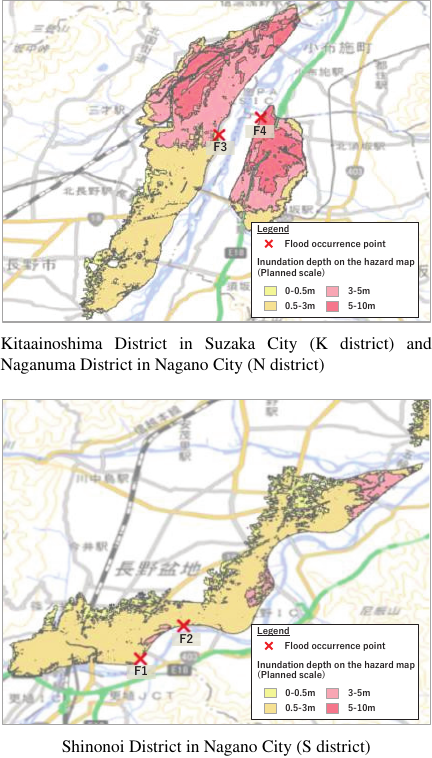
Fig. 3. Flood occurrence points and flood hazard area.
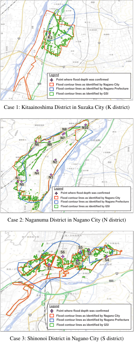
Fig. 4. Inundation depth points and inundation depth according to the information on-site.
b. Data on inundation depth
The following data are adopted as the data for the inundation depth. Fig. 4 shows the points where the inundation depth is confirmed, and Table 3 shows the inundation depth at these points. In the data on the inundation depth in Suzaka City, the points of the inundation edge are confirmed from the contemporaneous photos taken, and these points are considered as the inundation depth of 0 m. However, in the data on the inundation depth in Nagano City, no suitable photo can be found, and the inundation points and inundation depth in a disaster record 27 are adopted as the data that are supposed to be acquired on the day of the disaster.
Table 3. Inundation points and inundation depth.

Table 4. Creation of inundation area of Kitaainoshima District in Suzaka City.

Table 5. Creation of inundation area of Naganuma District in Nagano City.

Table 6. Creation of inundation area of Shinonoi District in Nagano City.

c. Data of inundation area
In the areas to be covered in this study, the municipalities, Nagano Prefecture, and the Central Government (the GSI) examine and create the inundation area, and each inundation area is evaluated. In addition, the days that it takes until the inundation area is evaluated and created differ according to the district. Tables 4–6 show the day and time when the inundation area is created.
The method of publishing inundation areas differs according to the district as well. The information on the inundation areas created by the GSI is published as GIS data and is used unmodified. The information on the inundation areas of Suzaka City is handwritten on a large map. This information is photographed, and the GIS data are created using geo-referencing. As for the data of inundation area of Nagano Prefecture and Nagano City, the GIS data are created using geo-referencing based on the information of inundation area published in PDF.
3.3. Calculation of the Estimated Extent of Damage Using the Model
3.3.1. Estimated Extent of Damage at the Time When River Flood Is Detected (Phase 1)
Based on the information on flood occurrence of “the flood warnings and advisories for designated rivers” shown in Table 2, the authors extract the flood hazard area concerned and identify the residence points included in these areas. The authors calculate the inundation depth of each house and estimate the number of inundated houses. The flood-hazard contour delineates the area of continuous inundation. Consequently, Yokota in Shinonoi District and Komori in Shinonoi District on the left and right sides of Chikuma River, respectively, are included in the same flood hazard area. Taking K district as a sample case, Fig. 5 shows the residence points according to the inundation rank. Table 7 shows the estimated extent of damage.
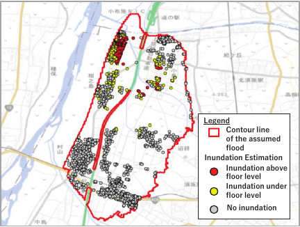
Fig. 5. Residence points according to inundation rank (example: K district).
Table 7. Estimated extent of damage according to inundation rank.

3.3.2. Estimated Extent of Damage at the Time When Inundation Depth Is Recognized (Phase 2)
The contour line of the flood hazard area explained in Section 3.3.1 is used as the inundation area. The inundation depth is calculated based on the values of inundation depth shown in Table 3 by adding the elevation at each point. N and S districts have multiple inundation points, and the difference between the maximum and minimum elevation of the water surface can be recognized. Thus, such elevations are calculated in each district, and based on these elevations, the inundation depth is calculated for the residences included in each inundation area. Table 8 shows the results of the totalization of the numbers of houses according to the inundation rank.
Table 8. Estimated extent of damage according to inundation rank.

Table 9. Estimated amount of damage according to inundation rank.

3.3.3. Estimated Amount of Damage at the Time When Inundation Area Is Recognized (Phase 3)
In the stage when the inundation area is evaluated, using the maximum and minimum water-surface elevations, respectively, estimated from the inundation depth, and the evaluated inundation area, the residence included in the inundation area is extracted, and the inundation depth is calculated. Using the inundation areas evaluated by the Central Government (the GSI), the prefecture (Nagano Prefecture), and the municipalities (Suzaka City and Nagano City) for comparison, the estimated extent of damage is calculated. Table 9 shows the results of the totalization of the numbers of houses according to the inundation rank.
3.4. Comparison Between Actual and Estimated Extent of Damage, Evaluation of Accuracy
The estimated extent of damage in each phase calculated in Section 3.3 is totaled for each district, and the result is compared with the actual extent of damage. Comparing the number of buildings for residences according to Zenrin with “Housing and Land Survey” by the Statistics Bureau 28, the former is 1.32–1.57 times as large as the latter. Thus, to convert the estimated results for comparison with the actual extent of damage, the estimated numbers are corrected by multiplying the numbers for Suzaka City by 1.32 and those for Nagano City by 1.57.
The evaluation is made in each district, and all three districts are reviewed. First, Fig. 6 shows the comparison between the estimated numbers of damage and the actual numbers in each phase in K district. Table 10 shows the percentage error to the actual numbers.
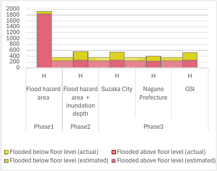
Fig. 6. K district: Estimated amount of damage according to inundation rank.
Table 10. K district: Percentage error between estimated values and actually measured ones.

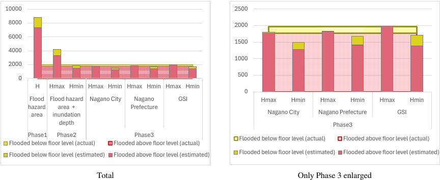
Fig. 7. N district: Estimated amount of damage according to inundation rank.
Table 11. N district: Percentage error between estimated values and actually measured values.

The estimated values of “flooded above floor level” have 7% error when the estimation of “flood hazard area of inundation \(+\) inundation depth” is recognized in Phase 2. When “inundation area \(+\) inundation depth” are evaluated by each organization in Phase 3, the estimated values have 7% or less error. Contrarily, the estimated values in Phase 1 are overestimated with a 647% error. If the actual inundation is lower than the estimated one, the damage is overestimated. Next, as for the estimated value of “flooded below floor level,” the overestimation with the error ranging from 70% to 190% in Phases 2 and 3 is recognized. Finally, in the estimated total values in Phases 2 and 3, the result is an overestimation with the percentage error ranging from 16% to 61%.
In K district, estimating Phases 2 and 3, the calculation of the number of houses flooded above floor level is relatively highly accurate, while that of houses flooded below floor level is less accurate. As for the time axis, without taking the time for the communication and analysis, half a day after the disaster occurrence (AM on October 13), the total number of estimated damaged houses can be calculated with an approximately 50% error and the estimated number of houses flooded above floor level with a less than 10% error.
Next, Fig. 7 shows the comparison between the estimated numbers of damage and the actual numbers in each phase in N district. Table 11 shows the percentage error to the actual numbers.
In Phase 1, the estimated extent of damage is overestimated with a 452% error, as in the case of K district. In Phases 2 and 3, where the inundation depth is acquired at multiple points, the estimation is based on the maximum and the minimum elevation of surface water, respectively. The difference between the maximum (\(H_{\textrm{max}}\)) and the minimum (\(H_{\textrm{min}}\)) water-surface elevation is 1.81 m. In the case of the maximum water-surface elevation, the number of houses flooded above floor level is overestimated with the error ranging from 0% to 12%, while in the case of the minimum water-surface elevation, the number of houses flooded below floor level is underestimated; overall, the estimates are underestimated except for the inundation area identified by the GSI.
Figure 8 shows the comparison between the estimated numbers of damage and the actual numbers in each phase in S district. Table 12 shows the percentage error to the actual numbers. In Phase 1, the estimated extent of damage is overestimated as in the cases of K and N districts with a 1,032% error—the largest error among the three districts. In Phases 2 and 3, where the inundation depth is acquired at multiple points, the estimation is based on the maximum and the minimum water-surface elevation, respectively. The difference between the maximum (\(H_{\mathrm{max}}\)) and the minimum (\(H_{\mathrm{min}}\)) water-surface elevation is 1.04 m. In the case of the maximum water-surface elevation, the number of houses flooded above floor level is overestimated with the error ranging from \(-\)28% to 164%, while in the case of the minimum water-surface elevation, the number of houses flooded below floor level is underestimated with the error ranging from \(-\)92% to \(-\)95%. In the case of S district, the inundation area evaluated by Nagano City and Nagano Prefecture in terms of houses flooded above floor level is overestimated, while that evaluated by GSI is underestimated. Confirming the number of houses included in the inundation area evaluated by the GSI, the number is 688 houses (the corrected number) with a \(-\)47% error with regard to the actual numbers. This result is close to the percentage error of \(-\)54% of the estimated total number of inundated houses. This indicates that the inundation area estimated by the GSI would be underestimated, with the map likely reflecting a receding stage rather than the peak, as the institute published the data on October 15, three days after the disaster (Table 6).
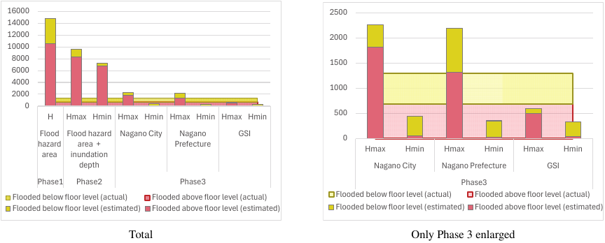
Fig. 8. S district: Estimated amount of damage according to inundation rank.
Table 12. S district: Percentage error between estimated values and actually measured values.

As for the inundation areas evaluated by Nagano City and Nagano Prefecture, excluding the results estimated by the GSI, comparing between the maximum water-surface elevation (\(H_{\mathrm{max}}\)) in N and in S districts, the inundation area in S district is overestimated significantly.
In acquiring the inundation depths at multiple points, as in the case of N and S districts, and estimating both the maximum and minimum water-surface elevation, the estimation result has a large error. Next, the authors hypothesize, analyze, and consider the factors of the large error.
Table 13. Density and average angle of gradient of residence point in each district.

3.5. Analysis of the Difference in Estimation Results According to District
3.5.1. Analysis on the Difference in Estimation Results in Districts
In S district, different from K and N districts in the estimation based on the maximum water-surface elevation (\(H_{\mathrm{max}}\)), the number of houses is overestimated, and in the estimation based on the minimum water-surface elevation (\(H_{\mathrm{min}}\)), it is underestimated. This point is considered by comparing N and S districts.
First, comparing the differences between \(H_{\mathrm{max}}\) and \(H_{\mathrm{min}}\) in N district and S district, the differences are 1.81 m and 1.04 m, respectively; that is, the difference in elevation is smaller in S district. However, the authors suppose that, as background factors, the topographic features and the distribution density of houses would influence the overestimation of the number of houses in S district.
As for the influence of topography, the angle of gradient of a 5 m mesh including houses is calculated to analyze the topographical features. If the angle of gradient is gentle, a minuscule change in water level would extend the inundation range easily, which could influence the estimation of the number of houses. Next, the density of houses is calculated using the area of the inundation area and the number of houses within the inundation area. If the density of houses within the inundation area is high, the change in water level would increase the error.
Table 13 shows the results of the analysis. The comparison between N and S districts shows the following characteristics. The density of houses within the inundation areas evaluated by three organizations in S district is 1.7–6.2 times as large as that in S district. The average angle of gradient in 5 m mesh within the inundation areas grasped by three organizations in S district is 0.66–0.82 times as low as that in N district. That is, the topography in S district is flatter. The abovementioned data indicate that the topography is gentler and the density of houses is higher in S district; that is, the error of the estimation of the number of houses caused by the change of the water-surface elevation would become more notable.
To mitigate the error, the following response is considered effective.
To reflect the change of the inundation depth more precisely, observation points are to be added in an area where the houses are built densely and water-surface elevation can be captured more accurately. The influence of housing density and the topographical characteristics could be localized, and the error could be mitigated by dividing the inundation division into smaller divisions for the analysis.
3.5.2. Evaluation by Division of Districts
Based on the above considerations, the analyses and evaluations are made by dividing the district into smaller divisions. To confirm the effectiveness of such divisions where the houses are built densely, S district is divided for the verification of accuracy.
(1) Criteria for division of district
As the criteria for the division of districts, the topographical elements with relatively high elevation are selected. Concretely, river embankments, main roads (national road), and rail routes are selected.
Consequently, S district is divided into three divisions (Fig. 9). Based on the elevations of the inundation surface acquired from the inundation confirmation points in each division, the water-surface elevation is calculated in each division. If multiple inundation confirmation points are present in a division, the average value is considered as the water-surface elevation.
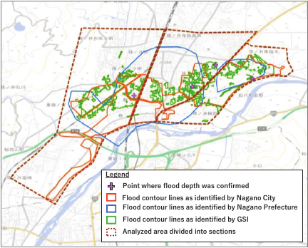
Fig. 9. Result of division of district in S district.
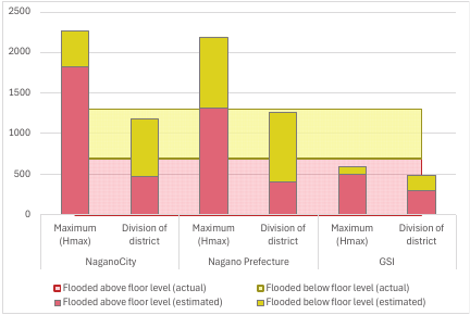
Fig. 10. Comparison of damage estimation with division and without division.
(2) Result of estimating the division of districts
Figure 10 shows the cases with and without the division of the district, respectively, in the inundation area evaluated by each organization (Nagano City, Nagano Prefecture) in S district. Table 14 shows the percentage error. The data of the GSI are excluded from the analysis because they have a significant tendency to overestimate, as shown in Section 3.4.
As a result of the estimation, the error of estimating the houses flooded above floor level based on the data evaluated by Nagano City improves from 164% to \(-\)31%. The error of the total including the houses flooded below floor level improves from 73% to \(-\)9%.
The error of estimating the houses flooded above floor level based on the data grasped by Nagano Prefecture improves from 92% to \(-\)41%. The error of the total including the houses flooded below floor level improves from 68% to \(-\)4%.
Table 14. Percentage error of estimated value with division of district to measured value.

(3) Consideration of the results of the analysis
The authors confirm that the division of districts brings about a significant decrease of error in the area where the houses are built densely. However, the tendency of underestimation is still recognized even after the division of the district. This underestimation would be influenced by the following two factors. First, in the case of multiple observation points in a district, the change in inundation depth would not be correctly reflected because the average values are used. Second, the criteria for the division would differ from the actual division.
4. Considerations
4.1. Accuracy and Effectiveness of the Proposed Model
The model of successive estimation constructed in this study uses post-disaster information acquired in stages and realizes the estimation of the number of houses flooded above floor level. Especially in Phases 2 (at the time when the inundation depth is recognized) and 3 (at the time when the inundation area is generally recognized), some districts achieve less than 10% error, showing the accuracy of estimation applicable practically. In the district where the overestimation is made in Phase 3, the accuracy of estimation is improved significantly by taking the density of houses into consideration and dividing the district into multiple divisions. However, in Phase 1 (at the time when river flood is detected), overestimation occurs in all the districts. Such estimation is, however, still useful as a reference value to evaluate the maximum value of disaster scale.
-
K district (Kitaainoshima District in Suzaka City): The error in the number of houses flooded above floor level in Phase 2 is 7%, and that in Phase 3 (based on the information examined by Suzaka City) is 6%.
-
N district (Naganuma District in Nagano City): The error in the number of houses flooded above the floor level in Phase 2 is 86% and in Phase 3 (based on the information grasped by Nagano Prefecture) is 3%.
-
S district (Shinonoi District in Nagano City): The error in the number of houses flooded above the floor level in Phase 2 is 1,112% and in Phase 3 (based on the information grasped by Nagano City) is 164%. The error is improved to \(-\)31% in Phase 3 by taking the influence of housing density into consideration and dividing the district into multiple divisions.
The above result shows that the scale of damage, which is necessary for disaster response, can be evaluated by practically using the information acquired successively on-site. It is revealed that building density significantly influences the accuracy of the estimation, and the addition of observation points and the division of a district into multiple divisions contribute to improving the accuracy in the high-density area. Such knowledge is considered useful to the effective information collection according to the degree of building density and the improvement of estimation.
As mentioned above, by using the information to successively update estimates as datasets are obtained and shared by relevant agencies over several days, the maximum scale of disaster can be evaluated first, and then the information can be provided with higher accuracy depending on the information acquired thereafter.
4.2. Applicability to Practical Work
By applying to the practical works, the operational plan can be formulated based on the extent of residential property damage. The material and human resources necessary for building damage assessment, volunteers, and disposal of disaster waste can be calculated using the results of damage estimation and applying the methods of previous studies. Thus, the plan could be implemented on a quantitative basis already in the stage of formulating a plan for disaster response.
The extent of residential property damage can be used as an index to ascertain whether only the officials of the municipality concerned could respond to a disaster or whether the support from the officials of other local governments should be asked for. For example, if the number of houses flooded above floor level exceeds the capacity of the officials of the local government concerned, this could be used as a trigger to judge whether support should be dispatched. In the case of Typhoon Hagibis in 2019, support officials were dispatched to 23 municipalities via “Counter Support System” of the Ministry of Internal Affairs and Communications 29. However, the time of actually begin providing post-disaster support varies among the municipalities ranging from 3 to 25 days (7 days on average). The application of this model is considered to enable to swiftly judge the necessity of support dispatch even on the day when a disaster occurs, arrange dispatch, and shorten the time until the start of dispatch. During a wide-area disaster, the effectiveness of the dispatch of officials could be maximized by prioritizing the support resources among the multiple damaged municipalities.
4.3. Problems
The following problems are revealed by this study.
(1) General-purpose model of division of district
In the area where the houses are built densely, large scatter is recognized. The improvement of accuracy by dividing the district into multiple divisions is confirmed, but it remains unclear to what extent of density of houses should be set as the threshold to divide the district. In the future, the appropriate threshold should be established based on the density of houses by increasing the cases for comparison. River embankments, main roads, and rail routes are applied to the criteria for division of districts in this study, but further examinations are required to ascertain whether these criteria could be applied to other districts and different conditions. A model of division of districts, taking the characteristics affecting the damage estimation into consideration, should be constructed.
(2) Application to district with steep gradient
The districts this study covers are relatively gentle areas with the river slope ranging from \(1/1000\) to \(1/1500\). Thus, the application of the model in a district with a steep gradient is not confirmed. As the variation of stream of water and inundation depth could be different, the effectiveness of the model should be evaluated.
(3) Problem of sharing data and estimation results
The application of this model assumes the sharing of the data necessary to estimate the extent of residential property damage. In this study, the authors make the evaluation using the materials in the past and the contemporaneous temporal information available. However, during an actual disaster, the process of establishing mechanisms such as systems and operations should be examined to successively collect information on inundation depth and inundation area as data and share the results of estimation among the local governments concerned.
(4) Practical use of other sensors
In addition to the information on inundation area based on field surveys and aerial photos, the data acquired from satellite images, IoT sensors, and so on should be incorporated. By incorporating these data in smaller time units, it should complement the areas that cannot be recognized on-site and supplement the lack of information on-site.
5. Conclusions
In this study, the authors construct a model to successively update estimates as datasets are obtained and shared by relevant agencies over several days, corresponding to the staged acquisition of information after a river flood: a) Phase 1, when flood occurrence is detected, b) Phase 2, when inundation depths or edges are recognized through initial on-site observations, and c) Phase 3, when a roughly identified inundation area is delineated based on field surveys or aerial observations by disaster response agencies such as municipalities, prefectures, and GSI.
In Phases 2 and 3, the model estimated the inundation depth of houses flooded above floor level with an error of less than 10% in some areas, indicating sufficient accuracy for practical use. In high-density residential areas, the estimation accuracy was significantly improved by dividing the district into multiple sub-areas, whereas a tendency to overestimate was observed in Phase 1; however, such estimation remains useful as an upper-bound reference for understanding the maximum potential scale of damage.
The approach targets conditions for ponding in riverine flooding. Near breach jets or in steep reaches, the horizontal-surface assumption can break down; thus, we exclude high-velocity buffers and report Hmax/Hmin envelopes. In dense, low-slope urban areas, small vertical errors near the 0.5-m threshold can flip classification; defining an uncertainty band (0.3–0.6 m) and subdividing analysis domains by levees/arterial roads/railways mitigated biases in S district.
However, there remain problems such as generalizing the criteria for division of district, taking the density of houses into consideration, verifying the applicability of this model in an area with a steep gradient, the arrangement of data collection and sharing in time of disaster, and examining the use of IoT sensor and satellite images. In the future, we aim to further develop a framework that supports disaster response swiftly and effectively by utilizing information acquired in stages immediately after disaster occurrence.
- [1] Cabinet Office, “Guidelines for earthquake response in local cities, etc.,” 2013 (in Japanese). https://www.bousai.go.jp/jishin/chihou/pdf/chihou_guidelines.pdf [Accessed December 12, 2024].
- [2] H. Fujiwara et al., “A comparative analysis of local government officials and ‘the general adviser for disaster management (GADM)’ on management work through the disaster response process,” J. of Social Safety Science, No.39, pp. 255-265, 2021 (in Japanese). https://doi.org/10.11314/jisss.39.255
- [3] Y. Mizui and H. Fujiwara, “Estimation of house cleanup work volume based on disaster volunteer center work management data—The case of the 2018 Kurashiki City Mabi—,” J. of Social Safety Science, No.41, pp. 219-228, 2022 (in Japanese). https://doi.org/10.11314/jisss.41.219
- [4] N. Hirayama and Y. Kawa, “Estimation procedure for quantity of disaster waste from the viewpoint of emergency responses of public authorities at flood disaster,” Environmental Systems Research, Vol.33, pp. 29-36, 2005 (in Japanese). https://doi.org/10.2208/proer.33.29
- [5] N. Hirayama, S. Nakamura, N. Fukuwa, and K. Nomura, “Quantitative estimation procedure for disaster debris using inundation assumption map in initial response to flooding disaster,” Proc. of the 31st Annual Conf. of Japan Society of Material Cycles and Waste Management, pp. 105-106, 2020 (in Japanese). https://doi.org/10.14912/jsmcwm.31.0_105
- [6] A. Onishi, “Fundamental study on flood waste estimation in the anticipated inundation area of the Kinugawa River: Housing and building flood damages,” Planning and Public Management, Vol.39, No.4, pp. 33-44, 2016 (in Japanese). https://doi.org/10.14985/jappm.39.4_33
- [7] H. Ishii and K. Ikeuchi, “New method to estimate flood waste using the data of the number of damaged houses and residential analysis,” J. of Japan Society of Civil Engineers, Ser.B1 (Hydraulic Engineering), Vol.76, No.2, pp. I_1447-I_1452, 2020 (in Japanese). https://doi.org/10.2208/jscejhe.76.2_I_1447
- [8] Ministry of the Environment, “Method of estimating the amount of disaster waste, etc. generated,” 2023 (in Japanese). http://kouikishori.env.go.jp/guidance/download/pdf/046_gi14-2.pdf [Accessed December 12, 2024]
- [9] Ministry of Land, Infrastructure and Transport, “Interim summary of emergency temporary housing construction essentials,” 2012 (in Japanese). https://www.mlit.go.jp/common/000211741.pdf [Accessed December 12, 2024]
- [10] Cabinet Office, “Guideline for the implementation system of residential damage recognition services related to disasters,” 2024 (in Japanese). https://www.bousai.go.jp/taisaku/pdf/r605saigai_tebiki_full.pdf [Accessed December 12, 2024]
- [11] Fire and Disaster Management Agency, “Fire and disaster reporting procedures,” 2021 (in Japanese). https://www.fdma.go.jp/laws/tutatsu/items/210520oukyuu29.pdf [Accessed December 12, 2024]
- [12] K. Yoshimori and Y. Usuda, “Analysis and discussion on the early identification of the estimated number of damages caused by inundated dwellings using prefectural damage reports,” J. of Disaster Information Studies, No.21-2, pp. 169-180, 2023 (in Japanese).
- [13] H. Shirozu, K. Kinjo, H. Yamamoto, and K. Asai, “Study on estimation method of inundation area and depth using SAR data,” J. of Japan Society of Civil Engineers, Ser.B1 (Hydraulic Engineering), Vol.75, No.2, pp. I_1471-I_1476, 2019 (in Japanese). https://doi.org/10.2208/jscejhe.75.2_I_1471
- [14] K. Kageyama et al., “Demonstration of flood detection using satellites during the Kyushu floods in July 2020,” J. of Japan Society of Civil Engineers, Ser.B1 (Hydraulic Engineering), Vol.77, No.1, pp. 150-157, 2021 (in Japanese). https://doi.org/10.2208/jscejhe.77.1_150
- [15] N. Yamamuro and K. Hirano, “Examination of effectiveness of flood area estimation during flooding disasters using SNS posts – Case study on Typhoon Hagibis in 2019 –,” Report of the National Research Institute for Earth Science and Disaster Resilience, No.86, pp. 1-10, 2022 (in Japanese). https://doi.org/10.24732/NIED.00003452
- [16] K. Yoshida, “Provisional inundation depth map in the heavy rain event in July 2018 – Estimation of inundation area and depth during disaster using social media and DEM –,” J. of the Japan Society of Photogrammetry and Remote Sensing, Vol.60, No.6, pp. 323-326, 2021 (in Japanese). https://doi.org/10.4287/jsprs.60.323
- [17] K. Uzaki and N. Ohashi, “Development of analytical method of regional inundation depths and flood velocities by using social media information,” Advances in River Engineering, Vol.27, pp. 551-556, 2021 (in Japanese). https://doi.org/10.11532/river.27.0_551
- [18] T. Sayama and K. Takara, “A data assimilation technique for real-time inundation mapping with local flood information,” J. of Japan Society of Civil Engineers, Ser.B1 (Hydraulic Engineering), Vol.74, No.4, pp. I_1297-I_1302, 2018 (in Japanese). https://doi.org/10.2208/jscejhe.74.I_1297
- [19] T. Sayama et al., “Flood inundation mapping by assimilating local information – Practical improvement and application to the Oda River Flooding in July 2017 –,” J. of Japan Society of Civil Engineers, Ser.B1 (Hydraulic Engineering), Vol.75, No.2, pp. I_1465-I_1470, 2019 (in Japanese). https://doi.org/10.2208/jscejhe.75.2_I_1465
- [20] Ministry of Land, Infrastructure, Transport and Tourism, “Guide to analyzing damage indicators for flooding,” 2013 (in Japanese). https://www.mlit.go.jp/river/basic_info/seisaku_hyouka/gaiyou/hyouka/pdf/higaisihyou_h25.pdf [Accessed December 12, 2024]
- [21] National Institute of Informatics, “Database of flood warnings and advisories for designated rivers,” CPS-IIP Risk Watcher. http://agora.ex.nii.ac.jp/cps/weather/river/ [Accessed December 12, 2024]
- [22] Nagano prefecture, “5th disaster control headquarters meeting (Typhoon No.19, 2019),” (in Japanese). https://www.pref.nagaNo.lg.jp/bosai/kurashi/shobo/bosai/bosai/r1typhoon19/documents/dai5-2.pdf [Accessed December 12, 2024]
- [23] T. Ise et al., “Synthesis and sharing of disaster information by ISUT – Case of Typhoon Faxai and Hagibis (Typhoon No.15 and 19) in 2019 –,” Technical Note of the National Research Institute for Earth Science and Disaster Resilience, No.455, 2021. https://doi.org/10.24732/NIED.00002445
- [24] Disaster Management Office, Planning Department, Geospatial Information Authority of Japan, “Responses of Geospatial Information Authority of Japan to the Typhoon Hagibis (2019),” 2020 (in Japanese). https://www.gsi.go.jp/common/000227245.pdf [Accessed December 12, 2024]
- [25] Cabinet Office, “Application of disaster relief act to disaster caused by Typhoon No.19 in 2019 (13th Report),” 2019 (in Japanese). https://www.bousai.go.jp/pdf/t19tekiyou_13.pdf [Accessed November 1, 2024]
- [26] Suzaka City, “The record of the Typhoon Hagibis in 2019,” 2022 (in Japanese). https://www.city.suzaka.nagaNo.jp/material/files/group/2/R0_taifu_kiroku.pdf [Accessed December 12, 2024]
- [27] Nagano City, “Nagano City disaster reconstruction plan,” 2020 (in Japanese). https://www.city.nagaNo.nagaNo.jp/documents/670/343808_1.pdf [Accessed December 12, 2024]
- [28] Statistics Bureau, Ministry of Internal Affairs and Communications, “Housing and land survey / 2023 Housing and land survey / Basic tabulation on dwellings and households Japan,” Portal Site of Official Statistics of Japan (in Japanese). https://www.e-stat.go.jp/en/stat-search/database?page=1&layout=datalist&toukei=00200522&tstat=000001207800&cycle=0&tclass1=000001207808&tclass2=000001207809&statdisp_id=0004021421&tclass3val=0 [Accessed December 12, 2024]
- [29] Ministry of Internal Affairs and Communications, “Dispatch of support staff to municipalities affected by the East Japan Typhoon in 2019” (in Japanese). https://www.soumu.go.jp/main_content/000722234.pdf [Accessed December 12, 2024]
This article is published under a Creative Commons Attribution-NoDerivatives 4.0 Internationa License.