Paper:
Interdisciplinary and Transdisciplinary Approaches in an International Research Project for Climate Resilience: The HyDEPP-SATREPS Project Between the Philippines and Japan
Miho Ohara*,†, Patricia Ann Jaranilla-Sanchez**
 , and Fernando C. Sanchez, Jr.**
*The University of Tokyo
Be505, 4-6-1 Komaba, Meguro-ku, Tokyo 153-8505, Japan
†Corresponding author
**University of the Philippines Los Baños
Los Baños, Philippines

Interdisciplinary and transdisciplinary collaboration is becoming increasingly critical for disaster risk reduction and climate change adaptation as climate change accelerates. The authors have been leading an international research project between the Philippines and Japan to demonstrate how interdisciplinary and transdisciplinary approaches can explore new solutions toward sustainable development under future climate change. The project aims to evaluate future climate change impacts through the development of hybrid water-related disaster risk assessment technology combining climate change, hydrological, agricultural, and socio-economic models; further, it aims to provide policy recommendations to support sustainable local economic development. As each model had been separately developed by project members, both interdisciplinary and transdisciplinary approaches were necessary to integrate the individual models into a single hybrid model and apply it to the target area. However, project activities were limited due to COVID-19, especially because of travel restrictions and the lack of face-to-face or on-site visiting opportunities. Hence, various measures were adopted to efficiently undertake project activities even under such circumstances. This study analyzes the interdisciplinary and transdisciplinary approaches used under the project, focusing on the process of team building, co-creation of solution-oriented and transferable knowledge, and its integration. The difficulties in each process during COVID-19, the needs for interdisciplinary and transdisciplinary approaches, the ways explored to manage these needs, and lessons are described.
Process of dialogue with stakeholders
1. Introduction
The Sendai Framework for Disaster Risk Reduction (SFDRR) 2015–2030 1 defines four priorities for action to prevent new and reduce existing disaster risks: (i) understanding disaster risk; (ii) strengthening disaster risk governance to manage disaster risk; (iii) investing in disaster risk reduction (DRR) for resilience; and (iv) enhancing disaster preparedness for effective response and building back better in recovery, rehabilitation, and reconstruction. Among them, understanding disaster risk through evidence-based risk assessments is crucial for proper future climate resilience investments. The framework also highlights the importance of international collaboration for “generating evidence-based and practical guidance for implementation in close collaboration with States and through the mobilization of experts.”
The 2030 Agenda for Sustainable Development, which includes the Sustainable Development Goals (SDGs) 2, is also well known. It comprises 17 goals and 169 targets to be achieved by 2030, aiming to realize a sustainable society in which “no one is left behind.” Goals 11 (Sustainable Cities and Communities) and 13 (Climate Action) are closely related to the SFDRR. Koike 3 analyzed the interrelationships between disasters and SDGs across five domains: the build environment, environmental impacts, quality of life, water-food-energy nexus, and social systems. The author then proposed a conceptual model to illustrate these linkages (Fig. 1). According to this model, disasters affect both built and natural environments. These impacts influence the quality of life and water-food-energy nexus, ultimately affecting social systems. To achieve the SFDRR priority action of “understanding disaster risk,” we need to understand not only the impacts on individual targets but also their interrelationships as illustrated in this model. An interdisciplinary approach across disciplines is essential for understanding the overall structure of disaster impacts.
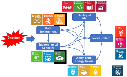
Fig. 1. Relationship between the SDGs and disasters 1.
Moreover, Ismail-Zadeh et al. 4 argued for the necessity of a paradigm shift in disaster science to a transdisciplinary system analysis with action-oriented research co-produced with multiple stakeholders, including policymakers. Takara 5 also noted that DRR cannot be achieved in a single academic discipline or sector. Ishiwatari et al. 6 define a transdisciplinary approach for DRR as an inclusive and collaborative implementation strategy that brings together stakeholders from various disciplines and sectors. A transdisciplinary approach facilitates diverse stakeholders’ collective efforts, encouraging them to work together to co-produce and co-implement solutions that reduce disaster risks. Especially in the fields of climate change adaptation (CCA) and DRR, Bendito and Barios 7 highlighted that the transdisciplinary process can help minimize trade-offs and maximize synergies and complementarities between DRR and CCA efforts.
Lang et al. 8 analyzed transdisciplinary research in sustainability science from the viewpoints of practice, principles, and challenges. The authors proposed three phases in the transdisciplinary approach: Phase A, collaboratively framing the problem and building a collaborative research team; Phase B, co-producing solution-oriented and transferable knowledge through collaborative research; and Phase C, integrating and applying the produced knowledge in both scientific and societal practice. Brandt et al. 9 reviewed transdisciplinary research and found that stakeholder empowerment was insufficient despite knowledge exchange between scientists and practitioners.
Motivated by this background, the authors have been leading an international research project between the Philippines and Japan to demonstrate how interdisciplinary and transdisciplinary approaches can explore new solutions toward sustainable development under future climate change impacts. The project title is “Development of a Hybrid Water-Related Disaster Risk Assessment Technology for Sustainable Local Economic Development Policy Under Climate Change in the Republic of the Philippines.” It is a five-year project under the Science and Technology Research Partnership for Sustainable Development (SATREPS), funded by the Japan International Cooperation Agency and Japan Science and Technology Agency. Based on the project title and funding framework, this project is referred to as the “HyDEPP-SATREPS Project.”
While the project began in April 2020 in Japan, the start of the project was postponed in the Philippines due to the COVID-19 pandemic. When it finally began in June 2021, it was still influenced by the COVID-19 pandemic. Travel between the two countries was not allowed due to travel restrictions until mid-2022.
This study analyzes how interdisciplinary and transdisciplinary processes can be applied to real international collaborative projects. In particular, it compares the actual actions of the project with the three typical phases of transdisciplinary processes described in Lang et al. 8. Difficulties in each phase, approaches taken during and after the COVID-19 pandemic, and lessons are described.
2. Project Outline
2.1. Objectives of the Project
The World Risk Report 2024 reported the Philippines as the country with the highest rank in the World Risk Index 10. The country faces various disaster risks, including floods, droughts, high tides, earthquakes, and volcanic eruptions. Annually, the nation experiences an average of 20 typhoons, with approximately eight or nine typhoons making landfall, and often causing torrential rains and widespread flooding. A key concern is that frequent water-related disasters induced by future climate change may hinder sustainable development. As stated in the SFDRR, international collaboration can accelerate the generation of “evidence-based and practical guidance” for DRR.
Through collaboration between the Philippines and Japan, the authors’ project aims to evaluate future climate change impacts by developing a hybrid water-related disaster risk assessment technology that combines climate change, hydrological, agricultural, and socio-economic models. It especially focuses on the “water–food–energy nexus” and “social systems” shown in Fig. 1. This project aims to quantify the effectiveness of investments in DRR measures and propose policy recommendations for sustainable local economic development under climate change.
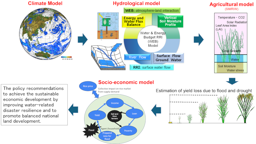
Fig. 2. Concept of a hybrid water-related disaster risk assessment model.
2.2. Hybrid Water-Related Disaster Risk Assessment Model
Figure 2 illustrates the concept of the proposed hybrid water-related disaster risk assessment model. Climate change, hydrological, agricultural, and socio-economic models, which had been developed separately by the project members, were connected to a single hybrid model.
The general circulation models developed by the Meteorological Research Institute (MRI) under the Japan Meteorological Agency were used as the climate change model. These models were the MRI-Atmospheric General Circulation Model (MRI-AGCM) version 3.2S (super-high resolution at 20 km) and version 3.2H (high resolution at 60 km), which were dynamically downscaled to a 5 km resolution and bias-corrected in Ushiyama et al. 11. Rainfall data for the past (1979–2003) and future (2075–2099) climates under the RCP2.6 (3.2H only) and RCP8.5 (3.2H and 3.2S) scenarios were used for the analysis.
The Water and Energy Budget-Based Rainfall–Runoff–Inundation (WEB-RRI) model, developed by Rasmy et al. 12, was employed as a hydrological model. This model integrates processes related to water and energy budgets, multi-layer soil moisture dynamics, land–vegetation–atmosphere interactions, and two-dimensional lateral water flows and flood inundation to simulate inundation events. Rainfall outputs from the MRI-AGCM climate model were used as inputs for the WEB-RRI model. The model employs one- and two-dimensional diffusive wave models for rivers and slopes, respectively, to calculate the runoff and inundation processes. Inundation occurs because of river overflow or water accumulation in low-lying areas due to heavy rainfall.
Next, regarding the agricultural model, the Simulation Model for Rice Irrigated/Rainfed Water-Use (SIMRIW) was used to simulate rice growth. This model simulates rice growth and yield in response to weather conditions by simplifying the underlying physiological and physical processes involved in rice crop growth 13. It was further updated to incorporate the effects of changes in atmospheric CO\(_{2}\) concentration and high temperatures on rice growth 14. Soil moisture simulated in the hydrological model and solar radiation, temperature, etc. in the climate model were used as inputs for the agricultural model. Agricultural production was simulated using the leaf area index (LAI), which is also used in hydrological models to consider transpiration. The model can simulate rice yield losses due to floods and droughts based on the soil moisture and inundation simulated by the WEB-RRI model.
Finally, the Agent-Based Model for Agricultural Activities Under Flood Risk (ABMAAF model), developed by Tanaka et al. 15, was used as the socioeconomic model. This model simulates thousands of individual farmers (“agents”) to represent the socio-economic dynamics of rice-farming households exposed to recurrent floods and droughts. Each farming household follows an annual cycle of planting, harvesting, income calculation, payment of taxes and investment costs, and adjustments based on financial conditions. Farmers’ experience of floods and droughts was considered using the agricultural yield loss calculated above. Lower harvests due to flooding decrease income, and increase reliance on loans or other coping mechanisms. By conducting annual simulations for past (1979–2003) and future (2075–2099) climates, 25-year behavior of the agricultural sector due to climate change can be estimated.
Overall, the hybrid water-related disaster risk assessment model aims to conduct an end-to-end simulation incorporating aspects from physical phenomena to socio-economic impacts. As each component model was developed within its respective discipline by different researchers, integrating these models into a single hybrid framework requires interdisciplinary collaboration among project members.
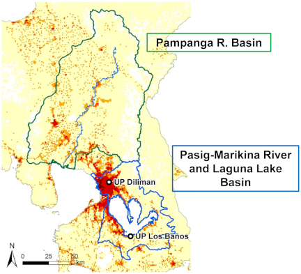
Fig. 3. Target areas of the project.
2.3. Target Area
The target area of the project is the Metro Manila area and its surrounding suburbs. Fig. 3 shows the location of each basin. The Pampanga River basin, with an area of 10,434 km\(^2\), is located in the northern part of Metro Manila. The Pasig–Marikina River and Laguna Lake basin are located in the central and southern parts, covering 3,974 km\(^2\). Laguna Lake is the third largest freshwater lake in Southeast Asia, with an area of approximately 900 km\(^2\) and average depth of 2.5 m. Among its many uses, the lake has a flood detention function that reduces flooding in Metro Manila but can also cause flooding in its low-lying and coastal areas.
One of the most severe floods in terms of casualties was caused by Typhoon Ketsana, locally known as “Ondoy,” in September 2009. It swept across Metro Manila and parts of Central Luzon. According to the Philippine National Disaster Coordinating Council, 295 people were killed and over 3.9 million were affected by the storm and subsequent flooding. Overall, the target area is at high risk of water-related disasters.
2.4. Research Organization
Researchers from both the Philippines and Japan are participating in the project. The Japanese research team is led by the first author of this study, Dr. Miho Ohara, at the University of Tokyo, with co-research organizations including the International Centre for Water Hazard and Risk Management (ICHARM) at the Public Works Research Institute under the auspices of UNESCO, Tohoku University, Nagoya University, University of Shiga Prefecture, and Kyoto University.
The Philippine research team comprises researchers from the Interdisciplinary Studies Center on Water at the University of the Philippines Los Baños (UPLB), University of Philippines (UP) Diliman, and UP Mindanao. The team is led by two co-authors of this study: Dr. Fernando C. Sanchez, Jr., as the Project Director and Dr. Patricia Ann J. Sanchez as the Project Manager.
Table 1. Phases A, B, and C.

3. Methods
As Lang et al. 8 proposed, an ideal–typical transdisciplinary research process has three phases: Phase A, collaboratively framing the problem and building a collaborative research team; Phase B, co-producing solution-oriented and transferable knowledge through collaborative research; and Phase C, integrating and applying the produced knowledge in both scientific and societal practice.
This study challenges how these ideal-typical processes can be applied to real international collaborative projects. In particular, it focuses on the difficulties and approaches taken during the COVID-19 pandemic since 2020, when the project began. Table 1 summarizes the contexts over the project period, situations before and after COVID-19, and the inter/transdisciplinary approaches explored by the project members.
3.1. Pre-Phase: Problem Framing And Team Building in an Interdisciplinary Approach
First, interdisciplinary team building among project members was conducted since the project began on June 3, 2021. As the project members had travel restrictions, the kick-off meeting of the project was held online on June 30, 2021, and attended by approximately 100 participants. Until September 2022, when the first joint site visit to the target area occurred after travel restrictions were lifted, all project activities were completed online.
As the project aims to evaluate climate change impacts by developing a hybrid water-related disaster risk assessment model, researchers from different academic fields gathered for the project. The participants were divided into four groups:
-
Group 1: Data collection and integration
-
Group 2: Flood and drought risk assessment
-
Group 3: Water-related disaster resilience assessment
-
Group 4: Sustainable local economic development
Researchers in information technology lead Group 1. Researchers in climatology, hydrology, and hydraulics are in Group 2. Group 3 includes researchers from multiple fields, including the social sciences. Finally, Group 4 has researchers in public policy and economics.
To develop a hybrid water-related disaster risk assessment model, a common understanding of climate change, hydrological, agricultural, and socio-economic models was needed to start discussions for joint research work. However, although they are essential for mutual understanding, the following activities were impossible due to the pandemic:
-
knowing researchers from different disciplines through face-to-face meetings;
-
engaging in group discussions in person; and
-
conducting field surveys to understand the situations in target basins or collect data.
Moreover, universities drastically shifted to online teaching. Owing to this shift, online meetings and discussions gradually became possible. As Internet connections in governmental organizations were much weaker than those in universities, activities focused more on university researchers. To strengthen the mutual understanding among project members, an e-learning program was implemented in the summer of 2021 to provide basic knowledge and understanding of essential assessment technologies under the project, such as climate change, hydrological, agricultural, and socio-economic models, in addition to hazard/risk mapping. Considering the limited Internet capabilities available to university members, e-learning was mainly via on-demand learning (self-learning with downloaded videos and materials), coupled with online sessions for Q&A and discussions in a limited time.
3.2. Phase A: Problem Framing and Team Building During COVID-19
After September 2021, Phase A (problem framing and team building) started also with cooperative governmental organizations, as listed in Table 2. Note that the SATREPS framework requires the establishment of cooperative organizations (non-research organizations) that can provide support and advice to research organizations. Hence, these four cooperative organizations were invited by expecting their support, such as providing necessary data and advice for the project. During this phase, the Internet situation in governmental organizations gradually improved. Then, the second e-learning session was conducted by inviting officers from cooperative organizations to enhance mutual understanding.
Table 2. Stakeholders for transdisciplinary approaches.

3.3. Phase A: Problem Framing and Team Building After COVID-19
In September 2022, Japanese members were allowed to visit the Philippines for the first time since the beginning of the project, as the impact of COVID-19 eased. Official field surveys of the two target river basins were conducted for the first time by project members from both the countries. Thereafter, face-to-face interactions between project members from these two countries became possible.
Through these field surveys, the necessity of involving other organizations at both the national and local levels was identified. In particular, the involvement of local governmental units (provincial, municipal, and barangay (smallest governmental units, the municipality)) and community leaders was also considered. Although communication with these organizations had been difficult during COVID-19 due to their weak Internet connection, a transdisciplinary approach with organizations other than the cooperative organizations listed in Table 2 was newly explored in this phase.
Fig. 4. Process of dialogue with stakeholders.
3.4. Phase B: Co-Creation of Solution-Oriented and Transferable Knowledge
In Phase A, the understanding of the local target area among project members was enhanced, and the development of the assessment model was accelerated through both face-to-face and online discussions. Based on analyses using the developed hybrid water-related disaster risk assessment model, flood and drought risks were quantified for past (1979–2003) and future (2075–2099) climates using the RCP2.6 and RCP8.5 scenarios. Project members visited each cooperative organization to engage in face-to-face discussions and obtain feedback.
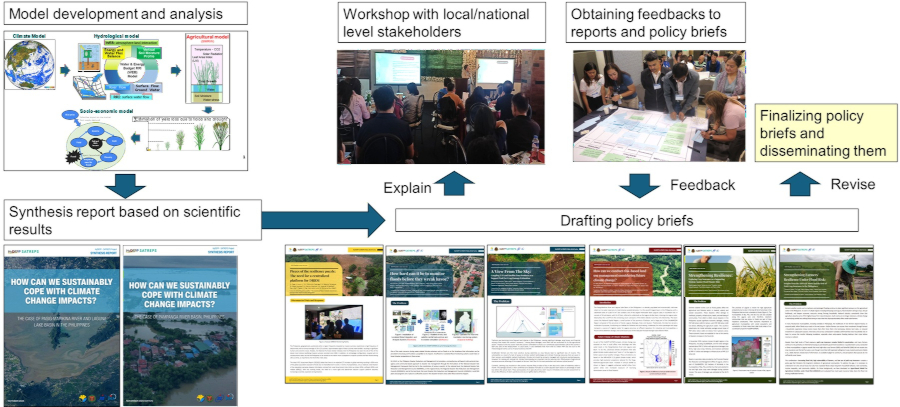
Lang et al. 8 described the importance of designing solution-oriented collaboration among different disciplines, and between researchers and actors from outside academia. For the research project, our final goal was to propose policy recommendations for sustainable local economic development under climate change conditions, as mentioned in Section 2.1. To achieve this goal, solution-oriented collaboration had to be explored in this phase to jointly draft policy recommendations. Consequently, the process described in Fig. 4 was proposed and implemented.
To demonstrate the end-to-end approach based on the findings from the hybrid model, a “Synthesis Report” summarizing findings from the analysis of each model and direction of policy recommendations was drafted. For key messages to specific related organizations, several draft policy briefs were also drafted to provide more comprehensive materials for disseminating the recommendations. This was only performed by academic members. However, from the viewpoint of implementation, these draft documents may include unrealistic recommendations due to an insufficient understanding of the institutional background, ongoing actions, or local situations of target basins. To address these concerns, drafted documents need to be validated with stakeholders to obtain feedback and suggestions through workshops or direct communication with each organization.
3.5. Phase C: Integration of Co-Created Knowledge
Finally, all drafted documents were revised to reflect the feedback from stakeholders. Phase C, as proposed by Lang et al. 8, included both the integration and application of co-created knowledge. However, considering that this is a research project, we decided to focus only on the integration of co-created knowledge because the application will come after the research project.
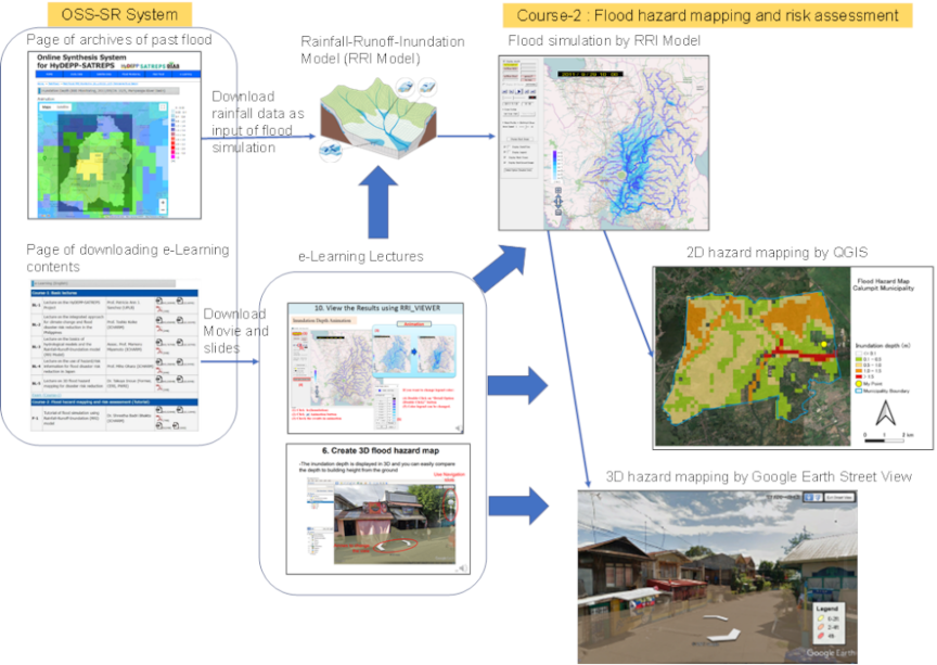
Fig. 5. Flowchart of e-learning using OSS-SR.
4. Team Building and Capacity Development via the e-Learning Program During COVID-19
4.1. e-Learning for Interdisciplinary Understanding
As the first activity in the project during COVID-19, an e-learning program was developed to enhance the basic understanding of climate change, hydrological, agricultural, and socioeconomic models, in addition to hazard/risk mapping. It was launched in the summer of 2021 for project members, as well as students and university staff supervised by project members.
The developed e-learning program comprised three courses:
-
Course 1:
Lectures on the background and current situation of DRR and climate change.
-
Course 2:
Tutorials on flood simulation, hazards, and risk mapping.
-
Course 3:
Lectures on assessment models, including hydrological, agricultural, and socio-economic models, and tutorials on using satellite image data.
Since Internet connections were not always stable for some project members in the Philippines, the e-learning program was designed to combine self-study and live online sessions. Participants downloaded lecture materials (MP4 and PDF files) from the designated website and studied them independently. Several Q&A sessions were also included, allowing participants to ask questions directly to the lecturers.
Each session was designed as follows:
-
Opening session: Opening ceremony and explanation of the e-learning courses and how to use the e-learning system.
-
Introduction session: Outline and key points of each lecture presented by the lecturers.
-
Q&A session: Questions and discussion.
-
Closing session: Review of the e-learning program (exams and assignments) and issuance of certificates.
4.2. System for Supporting e-Learning
An Online Synthesis System for Sustainability and Resilience (OSS-SR) was developed to support e-learning programs. The preliminary concept of the OSS-SR structure under the project comprised four components: an introduction page, flood and drought monitoring, sharing of flood and drought risk assessment results, and e-learning.
OSS-SR was developed using the Data Integration and Analysis System (DIAS) platform 16, which was developed in 2006 in Japan to provide massive data storage and an analytical environment for collecting Earth observation data under the initiative of the Japanese Ministry of Education, Culture, Sports, Science and Technology.
Figure 5 illustrates how OSS-SR supports the e-learning process. It shows the flow of Course 2. Participants could download the e-learning content (videos and PDF slides) on their own. After studying the lectures, they could take tutorials on flood simulations, hazards, and risk mapping. Rainfall data could be downloaded from the OSS-SR page as input and flood simulations could be performed using the hydrological model. Tutorial data were prepared for the Pampanga River basin, one of the target basins. Following the self-study lecture, participants created 2D flood hazard maps using the inundation depth distribution data from the simulation. In addition, they created 3D flood hazard maps using the Google Earth Street View function.
The OSS-SR system was also used to manage the learning process. An online examination system was developed on OSS-SR to certify course completion. The exam comprised five questions from each lecture. A certificate for completing Course 1 or 3 was issued at the closing session to those who correctly answered 80% or more of the questions. A certificate for completing Course 2 was awarded to participants who submitted the hazard/risk mapping results.
In 2025, a new server was installed in the project room in the UPLB. As part of technology transfer, the OSS-SR will operate on this server after the project ends in May 2026.
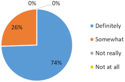
Fig. 6. Answers to the question, “Has this e-learning contributed to improving activities of your team or department?”
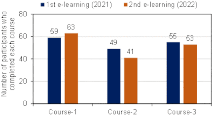
Fig. 7. Comparison of the number of participants who completed each e-learning course in 2021 and 2022.
4.3. Feedback from the Participants
In total, 82 participants were there in Course 1, 79 in Course 2, and 78 in Course 3. At the end of the program, 59 participants completed Course 1, 49 completed Course 2, and 55 completed Course 3. Meanwhile, 49 participants completed all three courses. Each participant received a certificate of completion for each course.
To understand the effectiveness of the e-learning program, a questionnaire survey was conducted through Google Forms. In total, 47 participants answered it. As shown in Fig. 6, 74% of respondents indicated that the e-learning program improved the activities of their teams, departments, or institutions.
4.4. Expansion of e-Learning as Transdisciplinary Collaboration
As COVID-19 continued to influence the project, e-learning was continuously provided until 2022 to members who had not completed it by 2021. Additionally, as a transdisciplinary approach, governmental cooperative organizations were invited to participate in e-learning to enhance their understanding of the project.
Among 93 participants in 2022, the number of participants who completed Course 1 was 63, Course 2 was 41, and Course 3 was 53, as shown in Fig. 7. Meanwhile, 40 participants completed all three courses. Among them, 44, 34, and 38 participants from the cooperative governmental organizations listed in Table 2 completed Courses 1, 2, and 3, respectively.
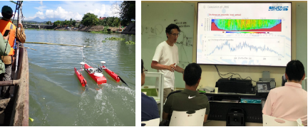
Fig. 8. Training on river flow monitoring.
Clearly, e-learning could be successfully expanded to governmental organizations, even though poor Internet connections had been a concern beforehand. Thus, sharing knowledge and understanding is the first step toward effective collaboration.
5. Team Building and Capacity Development by e-Learning Program After COVID-19
5.1. Training on Monitoring Technology
Providing lectures and tutorials on computer-based work was possible through e-learning, as described in the previous section. However, physical exercises, such as learning how to collect data using monitoring equipment, were impossible. After COVID-19, such exercises focused more on project activities. Fig. 8 shows the river flow-monitoring training. Under this project, river flow monitoring equipment (acoustic Doppler current profiler) was provided, and training on monitoring and analyzing the data was conducted.
Following the successful participation of government officers in the e-learning program, monitoring training was expanded to governmental officers to enhance mutual understanding across the organizations. In addition to river flow monitoring, crop growth and damage monitoring were also provided.
5.2. Training in Japan
Besides providing training in the Philippines, training in Japan also became possible. One-to-two weeks of training in Japan to learn about flood-protection facilities and disaster management was provided several times (Fig. 9). During the stay, additional hands-on training on the simulation model and the assessments learned in the e-learning program were also provided.
As the number of days spent in Japan was limited due to budget constraints, the e-learning system was effectively used for pre-learning before arrival in Japan.
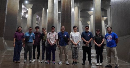
Fig. 9. Training in Japan (photo at the Metropolitan Area Outer Underground Discharge Channel).
6. Co-Creation of Solution-Oriented and Transferable Knowledge with National/Local Stakeholders
To demonstrate the end-to-end approach based on the findings from the hybrid model, a “Synthesis Report” summarizing findings from the analysis of each model and direction of policy recommendations was drafted. This report was separately drafted for two target river basins: the Pampanga River basin, and Pasig–Marikina River and Laguna Lake basin. In each report, flood and drought risks quantified for past (1979–2003) and future (2075–2099) climates using the RCP2.6 (low-emission) and RCP8.5 (high-emission) scenarios were described. As this study focuses on interdisciplinary and transdisciplinary approaches, only brief results are described here. In the Pampanga River basin, for discharges above around 2500 m\(^3\)/s, the daily mean extreme discharge is projected to be 1.3 times higher under future RCP8.5 scenarios than the past extremes. In addition, river discharge is projected to decrease for flows below 1000 m\(^3\)/s. As such, floods and droughts are likely to become more severe and frequent under high-emission scenarios compared to historical conditions. Moreover, the basin is projected to experience greater flood depths (exceeding 1 m to 2 m), which could lead to greater losses to agriculture and human settlements.
In the Pasig–Marikina River and Laguna Lake basin, both the intensity and frequency of floods are projected to increase. Meanwhile, droughts will not be significant in the future. The lowland and coastal areas along the Laguna Lake shore are projected to face greater flood depths (exceeding 1 m to 2 m) as the lake level increases in future scenarios. Because rapid urbanization is estimated in this flood area, the exposed population will be more than 10 times larger in the future. This may hinder regional development in the future.
To minimize future risks, a combination of countermeasures for hazard reduction, exposure reduction, vulnerability reduction, and capacity improvement was proposed. In particular, considering future population increases in the area, hazard control in urban areas and exposure control in rural areas that may become urbanized in the future were emphasized.
For key messages to specific related organizations, several policy briefs were also drafted, as shown in Table 3, to provide more comprehensive materials for disseminating the recommendations. Based on discussions among project members and consultations with cooperative organizations, topics such as a centralized data platform, flood monitoring, risk-based land use management, agricultural monitoring, climate resilience of farmers and fisheries, and crop insurance were selected for drafting policy briefs.
Table 3. Policy briefs developed under the project.

To validate these documents and obtain feedback, three different workshops for policy co-creation were held with local stakeholders in the Pampanga River basin in September 2025, local stakeholders in the Pasig–Marikina River and Laguna Lake basin in October 2025, and national-level stakeholders in November 2025. As described in Fig. 4, after both “Synthesis Report” and policy briefs were explained, feedback was collected from involved participants listed in Table 2.
In the workshop in the Pampanga River basin, it was suggested that “Integration of results in enhanced Local Climate Change Action Plan (LCCAP) of local government units, provincial and municipal levels” be added to ensure the consideration of projected risks in local adaptation and mitigation measures. “More collaborations between local government units and national agencies” and “Conduct information, education and communication campaigns to increase awareness of local communities especially on potential climate change and its impact to their localities” were also suggested.
At the workshop in the Pasig–Marikina River and Laguna Lake basin, these three points were edited in the documents beforehand. The comments on “More sediment flow control into the lake” and “Strengthening hydrological and sediment monitoring in major tributaries” were suggested. These helped the authors understand greater interests in sediment among local stakeholders.
After these local workshops, a workshop inviting the national organizations listed in Table 2 was held to share project achievements and feedback from the local workshops.
7. Conclusions
The HyDEPP-SATREPS project developed a hybrid water-related disaster risk assessment technology by combining climate change, hydrological, agricultural, and socio-economic models to provide policy recommendations to support sustainable local economic development. As each model was developed separately by project members, both interdisciplinary and transdisciplinary approaches were necessary to integrate the individual models into a single hybrid model and apply it to the target area. However, during the COVID-19 pandemic starting in 2020, project activities were initially limited.
This study analyzed how the ideal-typical processes proposed by Lang et al. 8 can be applied to real international collaborative projects. It focuses on the difficulties and approaches taken before and after the COVID-19 pandemic since 2020, when the project began.
The first interdisciplinary approach was adopted only by project members at the university. As the project aims to develop an integrated assessment model, understanding each basic model was essential. Thus, for team building under COVID-19 restrictions, an e-learning program was developed to enhance the basic understanding of each model as the first step in starting collaborative research. Participants successfully completed the learning process. As the next step, this e-learning program was expanded for officers in governmental organizations to start team-building and capacity development among cooperative organizations of the project as the start of the transdisciplinary approach. By applying an on-demand style and self-learning in a limited internet environment, e-learning was successfully used for team building.
After travel restrictions were eased, training was expanded to include on-site monitoring exercises and visits to Japan to learn from Japanese examples. In addition, as part of the transdisciplinary approach, dialogues with stakeholders at the local and national levels were undertaken to share the results of project activities. During the COVID-19 pandemic, the authors faced severe difficulties initially in communicating with local governments and conducting field surveys. However, as restrictions eased and with the start of local-level communication, new stakeholders were identified and their involvement expanded.
Consequently, methods for validating preliminary policy recommendations and realizing co-creation processes through a workshop style were developed and implemented. Feedback from related stakeholders was reflected in the report and policy briefs for sustainable development under future climate change.
The project is now nearing completion. The drafted documents for dialogue will continue to be elaborated upon and finalized toward implementation by stakeholders by the end of the project in May 2026.
Acknowledgments
This research was supported by the Science and Technology Research Partnership for Sustainable Development (SATREPS) in collaboration with the Japan Science and Technology Agency (JST, JPMJSA1909) and Japan International Cooperation Agency (JICA). We would like to express our gratitude to the participants at the workshops held under the project for their precious comments.
- [1] United Nations Office for Disaster Risk Reduction, “Disaster risk reduction and resilience in the 2030 Agenda for Sustainable Development.” https://www.preventionweb.net/files/46052_disasterriskreductioninthe2030agend.pdf [Accessed September 30, 2025]
- [2] The Global Goals, “The 17 goals.” https://globalgoals.org/goals/ [Accessed September 30, 2025]
- [3] T. Koike, “Presentation at the Asian Water Cycle Initiative (AWCI) session,” Asia-Oceania Group on Earth Observations (AOGEO), 2021. https://www.pwri.go.jp/icharm/ifi/awci/topics/20211029_14/6-1_Koike.pdf [Accessed September 30, 2025]
- [4] A. T. Ismail-Zadeh, S. L. Cutter, K. Takeuchi, and D. Paton, “Forging a paradigm shift in disaster science,” Nat. Hazards, Vol.86, No.2, pp. 969-988, 2017. https://doi.org/10.1007/s11069-016-2726-x
- [5] K. Takara, “Promotion of interdisciplinary and transdisciplinary collaboration in disaster risk reduction,” J. Disaster Res., Vol.13, No.7, pp. 1193-1198, 2018. https://doi.org/10.20965/jdr.2018.p1193
- [6] M. Ishiwatari et al., “Transdisciplinary approach: Toward innovative recovery and disaster risk reduction,” J. Disaster Res., Vol.19, No.3, pp. 534-538, 2024. https://doi.org/10.20965/jdr.2024.p0534
- [7] A. Bendito and E. Barios, “Convergent agency: Encouraging transdisciplinary approaches for effective climate change adaptation and disaster risk reduction,” Int. J. Disaster Risk. Sci., Vol.7, No.4, pp. 430-435, 2016. https://doi.org/10.1007/s13753-016-0102-9
- [8] D. J. Lang et al., “Transdisciplinary research in sustainability science: Practice, principles, and challenges,” Sustain. Sci., Vol.7, Suppl.1, pp. 25-43, 2012. https://doi.org/10.1007/s11625-011-0149-x
- [9] P. Brandt et al., “A review of transdisciplinary research in sustainability science,” Ecological Economics, Vol.92, pp. 1-15, 2013. https://doi.org/10.1016/j.ecolecon.2013.04.008
- [10] https://weltrisikobericht.de/worldriskreport/ [Accessed September 30, 2025]
- [11] T. Ushiyama, A. Hasegawa, M. Miyamoto, and Y. Iwami, “Dynamic downscaling and bias correction of rainfall in the Pampanga River basin, Philippines, for investigating flood risk changes due to global warming,” Hydrol. Res. Lett., Vol.10, No.3, pp. 106-112, 2016. https://doi.org/10.3178/hrl.10.106
- [12] M. Rasmy, T. Sayama, and T. Koike, “Development of water and energy budget-based rainfall-runoff-inundation model (WEB-RRI) and its verification in the Kalu and Mundeni River basins, Sri Lanka.” J. of Hydrol., Vol.579, Article No.124163, 2019. https://doi.org/10.1016/j.jhydrol.2019.124163
- [13] T. Horie, H. Nakagawa, H. G. S. Centeno, and M. J. Kropff, “The rice crop simulation model SIMRIW and its testing,” R. B. Matthews, M. J. Kropff, D. Bachelet, and H. H. van Laar (Eds.), “Modeling the Impact of Climate Change on Rice Production in Asia,” pp. 51-66, CAB International, 1995.
- [14] T. Horie, H. Nakagawa, and H. Y. Kim, “The effect of increased CO2 concentration and temperature on rice yield,” Optimization of Plant Nutrition: Proc. of the 9th Int. Plant Nutrition Colloquium, 1993.
- [15] T. Tanaka et al., “Assessing economic impact on rice farmers by flood disasters in Pampanga River Basin, Republic of the Philippines,” DPRI Annual Meeting 2025, Session No.E212, 2025 (in Japanese).
- [16] Data Integration and Analysis System Program. https://diasjp.net/en/ [Accessed September 30, 2025]
This article is published under a Creative Commons Attribution-NoDerivatives 4.0 Internationa License.