Research Paper:
Space-Air-Ground Integrated Intelligent Monitoring System for Geological Hazards Based on Multi-Source Information Fusion Technology
Sijing Chen*1, Yunyan Shao*1, Zikang Wu*2,*3,*4, Chengda Lu*2,*3,*4, and Min Wu*1,*2,*3,*4,†
*1School of Future Technology, China University of Geosciences
No.388 Lumo Road, Hongshan, Wuhan 430074, China
*2School of Artificial Intelligence and Automation, China University of Geosciences
No.388 Lumo Road, Hongshan, Wuhan 430074, China
*3Hubei Key Laboratory of Advanced Control and Intelligent Automation for Complex Systems
No.388 Lumo Road, Hongshan, Wuhan 430074, China
*4Engineering Research Center of Intelligent Technology for Geo-Exploration, Ministry of Education
No.388 Lumo Road, Hongshan, Wuhan 430074, China
†Corresponding author

Geological hazards exhibit strong abruptness and severe destructive effects, frequently occur worldwide, and pose a serious threat to human life and property. Conventional methods for geological hazard monitoring are inadequate for fulfilling the requirements of accurate and real-time monitoring under complex geological conditions. This study provides an intelligent system for geological hazard monitoring based on multi-source information fusion. The characteristics of space-based, airborne, and ground-based multi-source information were analyzed. Multi-source information fusion methods at different scales were also discussed. Subsequently, intelligent algorithms for hazard identification, spatiotemporal prediction, and real-time warnings in the field of geological hazard monitoring were explored. Furthermore, practical application cases of the system were presented, laying a foundation for research on the application of artificial intelligence to geological hazards.
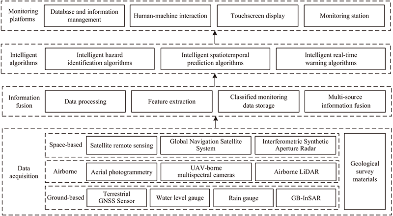
Overall architecture of geological hazard monitoring
1. Introduction
With the intensification of global climate change and human engineering activities, the frequency and impact of geological hazards continue to rise 1. Geological hazards are one of the major natural hazards threatening human life and property. Landslides and other geological hazards occur frequently worldwide, making intelligent monitoring of these hazards crucial.
Current geological hazard monitoring methods primarily utilize field surveys, point-based instruments, and single-technology approaches. Fu et al. processed optical remote sensing data to extract diverse geospatial information by integrating the multi-scale features of geological hazards 2. Qu et al. used remote sensing images before and after landslides and digital elevation model (DEM) data to construct a multi-channel dataset that was applied to distinguish landslides from other objects with similar spectral characteristics 3. Bu et al. developed a deep learning model combining speckle reduction and super-resolution techniques to process multi-temporal synthetic aperture radar (SAR) data, effectively suppressing speckle noise and markedly enhancing image resolution 4. Pattanaik et al. used software to generate 3D point clouds and DEMs from aerial images, and ground control points were collected for geographic registration and model error estimation to analyze landslide features 5.
However, these monitoring methods suffer from incomplete information acquisition, poor timeliness, and difficulty in capturing hazards. When faced with complex geological conditions and wide-area monitoring demands, these methods have limitations in terms of precise monitoring and fail to meet the requirements of high-precision monitoring.
Multi-source information fusion technology offers novel approaches for intelligent geological hazard monitoring by combining diverse data sources to provide comprehensive, precise, and real-time information, thereby improving monitoring accuracy and dependability. Curzio et al. studied its application for handling large-scale spatiotemporal datasets and proposed a fusion method that offers key theoretical and technical support for landslide surveillance 6. Dou et al. fused interferometric synthetic aperture radar (InSAR) data, unmanned aerial vehicle (UAV) images, satellite imagery, and field survey data to comprehensively analyze landslide failure mechanisms and hazard extents 7. Zhang et al. combined persistent scatterer interferometric synthetic aperture radar (PS-InSAR) and distributed scatterer interferometric synthetic aperture radar (DS-InSAR) methods, employing light detection and ranging (LiDAR)-derived DEM from UAV to reveal the actual microtopography and terrain features related to landslide movement 8.
These methods satisfy the monitoring requirements across extensive geological environments using multi-source information. Nonetheless, a detailed analysis of geospatial multi-source data and a relatively systematic monitoring framework tailored to diverse needs are lacking. Aiming at diverse practical scenarios in geological hazard monitoring, multi-dimensional space-based, airborne, and ground-based information is integrated by combining sensor, geographic, and meteorological information, enabling real-time monitoring.
Although multi-source information fusion provides comprehensive data, the processing and analysis of this vast amount of heterogeneous information requires powerful tools. In this context, artificial intelligence (AI) technologies play a significant role, and computer vision and predictive intelligent algorithms offer solutions for hazards monitoring 9. Traditional monitoring methods are gradually being replaced by intelligent approaches, especially in data processing and model construction, where AI shows significant advantages such as simulating, extending, and expanding human intelligence capabilities, thus enabling computer systems to perform cognitive tasks similar to humans. Deep learning algorithms handle large datasets and multi-level abstract complex relationships, employing specific methods and algorithms to achieve geological hazard monitoring 10. Various deep learning algorithms have great application potential in geological hazard monitoring. Their use in intelligent hazard identification and spatiotemporal prediction mainly focuses on image analysis, enabling the rapid acquisition of information for emergency responses 11.
In recent years, monitoring systems for geological hazards have developed rapidly. Dai et al. developed a framework that employed Earth observation techniques to construct a feasible landslide warning system 12. Zhu et al. integrated an intelligent computing architecture and implemented adaptive data sampling based on objective physical value changes within the embedded microcontrollers of sensor nodes 13. Chen et al. developed a novel data fusion technique based on generalized evidence theory that maps multi sensor data to landslide probabilities and basic probability assignments in intuitionistic fuzzy sets 14. Xu et al. developed a real-time landslide early warning system that employed 3D surveys to study the positions and sizes of landslides 15.
This study comprehensively applied multi-source information fusion technology and artificial intelligence to achieve accurate and intelligent monitoring, which is of great significance in the field of geological hazard monitoring. First, the characteristics of the multi-source geological information were analyzed. The methods of information fusion are then designed at multiple scales to enhance the integrity of the monitoring information. Intelligent algorithms have been developed for this purpose. Finally, a monitoring system architecture is established, and a detailed explanation of the system, combined with practical application cases, is provided, demonstrating the effectiveness of the proposed system.
2. Multi-Source Information Characteristics Analysis and Monitoring System Architecture Design
Geological hazard monitoring relies on large amounts of complex multi-source information. However, through information fusion, complementary advantages can be leveraged to offer more comprehensive information than single-source information. Accordingly, multi-source information is classified into space-based, airborne, and ground-based types for characteristic analysis, constructing an integrated space-air-ground architecture for intelligent geological hazard monitoring.
2.1. Multi-Source Information and Characteristics Analysis
Multi-source information is the core component for constructing integrated space-air-ground monitoring. To utilize and analyze this information for intelligent geological hazard monitoring, the applications and data provided by space-based, airborne, and ground-based intelligent monitoring technologies were analyzed separately.
(1) Space-based: Satellite remote sensing information
Satellite remote sensing offers wide-area geographic information using space-based technologies that depict the overall macro-scale status of geological hazards. The global navigation satellite system (GNSS) is an important application that offers real-time monitoring, high-precision positioning, and ease of use, with millimeter-level monitoring accuracy 16. Critical hazard features were extracted by applying interpretation techniques using satellite remote sensing. Recently, more satellites have been deployed in near-Earth orbit, with high-resolution or ultra-high-resolution optical satellite sensors providing large volumes of Earth observation data 17. InSAR, with its all-time, all-weather observations, and cloud-penetrating capabilities, achieves millimeter-level monitoring 18.
Space-based technologies provide extensive coverage and periodic information, but lack detailed local information. The revisit cycles of satellites and time required for data processing limit the real-time nature of space-based information. Optical satellite data generally take hours to days from collection to distribution, whereas SAR data, owing to complex interferometric processing, are delayed by days to weeks. This low update frequency hinders real-time wide-area monitoring requirements and restricts the monitoring of localized geological hazards, thus requiring integration with airborne or ground-based data.
(2) Airborne: Aerial and UAV information
Airborne technologies are characterized by high flexibility and resolution, enabling the acquisition of detailed aerial and UAV information over localized regions, which supports timely and rapid responses and assessments. Airborne platforms equipped with diverse sensors address geological hazards using advanced information processing technologies 19. Airborne technologies include aerial photogrammetry, UAV-borne multispectral cameras, and airborne LiDAR. Monitoring with UAVs has described the geometric form of geological hazards and evaluated the morphological and topographic changes in recent years 20. Aerial photogrammetry produces RGB optical images. UAV-borne multispectral cameras employ multispectral imaging to capture the detailed surface characteristics. A DEM was generated using airborne LiDAR point clouds. The generated digital orthophoto maps (DOM), digital surface models (DSM), and DEM were used to analyze the landslide morphology. Airborne technologies create three-dimensional (3D) models to support hazard analysis. Furthermore, UAVs are equipped with route planning and intelligent scheduling, leveraging edge computing to improve data collection efficiency, thereby achieving flexible deployment and swift responsiveness. However, constraints on battery capacity and flight altitude make it difficult to cover large areas, thereby limiting the operational and monitoring ranges. Under adverse weather conditions, UAV flights are affected to some extent, which limits their application.
(3) Ground-based: Surface monitoring information
Ground-based monitoring delivers high-precision, real-time measurements of surface deformation and key environmental triggers, such as hydrological and meteorological variables, which are essential for deciphering landslide mechanisms and supporting warning systems 21. Typical instruments include water-level gauges 22, ground-based InSAR (GB-InSAR) 23, and rain gauges 24, which enable continuous unmanned operation under all weather conditions. However, despite ground-based sensors being core high-precision real-time tools in landslide monitoring, particularly suitable for capturing local deformation and short-term dynamics, they are limited by their small coverage, high cost, and deployment difficulty. In practical applications, they are often combined with space- and air-based technologies (such as satellite InSAR and UAV surveys) to form a point-surface coordinated monitoring network, balancing accuracy and coverage to improve the reliability of landslide warnings.
(4) Geological survey materials
By studying geological survey materials, it is possible to identify the type and scale of past geological hazards and analyze the geological processes of evolution and change in a given area. Geological, topographic, and tectonic maps were used to identify potential hazard areas and to provide data for hazard monitoring and prediction.
2.2. Functional Requirements of the Monitoring System
The overall tasks related to geological hazards are summarized into three core functional aspects: intelligent hazard identification, intelligent spatiotemporal prediction, and intelligent real-time warning.
(1) Intelligent hazard identification
Intelligent hazard identification forms the foundation of geological hazard monitoring and analysis of multi-source information to identify impact areas.
(2) Intelligent spatiotemporal prediction
Intelligent spatiotemporal prediction aims to reveal the temporal and spatial evolution patterns of geological hazards and anticipate potential development stages in advance.
(3) Intelligent real-time warning
Intelligent real-time warning by combining outcomes from intelligent hazards identification and spatiotemporal prediction, based on predefined thresholds, promptly warns when hazards are imminent or have already occurred but have not yet caused severe consequences.
2.3. Intelligent Monitoring System Architecture
To satisfy the requirements of intelligent hazard identification, intelligent spatiotemporal prediction, and intelligent real-time warning, the overall architecture was designed to complement each other, as shown in Fig. 1, and included data acquisition, information fusion, intelligent algorithms, and monitoring platforms.
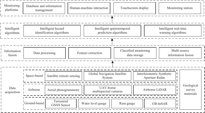
Fig. 1. Overall architecture of geological hazard monitoring.
(1) Multi-source information fusion
By analyzing monitoring information from sensors of various types and spatiotemporal characteristics, extracting useful information, and removing redundancies and contradictions, space-based, airborne, and ground-based information is fused for wide-area local-scale detailed and space-air-ground integrated monitoring.
Geological hazard fields involve multi-source and multi-modal data. Through real-time acquisition by multiple sensors, raw data are preprocessed via filtering, normalization, spatiotemporal interpolation, and other techniques to form a multi-source heterogeneous database for hazard monitoring and data-level fusion. Correlating multi-dimensional information, extracting relevant features, and performing similarity matching enable feature-level fusion. The results of feature-level fusion were used to build intelligent hazard identification, intelligent spatiotemporal prediction, and intelligent real-time warning, ultimately achieving decision-level fusion for system functionality.
(2) Intelligent monitoring algorithms
Intelligent monitoring algorithms are at the core of monitoring systems. These are embedded in the system through normal operations by applying deep learning to automatically identify patterns, predict trends, and assess warnings from massive amounts of information to achieve intelligent monitoring.
(3) Database and information management
A database architecture was constructed to organize and manage data effectively, ensuring integrity, consistency, and rapid access, thereby providing strong and efficient data support for analysis, visualization, and intelligent warnings. Through information management, an online intelligent analysis of monitoring data can be performed to extract valuable information, enabling real-time access to target information, and supporting real-time monitoring and decision-making.
(4) Monitoring platform (server, client, and app)
A user interface was designed, and an information service center was established to achieve real-time monitoring of the core geological hazard parameters on both PC and mobile terminals. The server handles core business logic processing, data access control, user authentication and authorization, and task scheduling. The client enables data visualization, presents geological hazards data, and monitors the parameters on the PC. The app provides mobile access, including real-time viewing of data, instant warning notifications, handling, remote control, and service configuration.
3. Multi-Source Information Fusion Methods
Multi-source information fusion methods have become a means of processing and analyzing information, complementing each other’s strengths and achieving basic unification of spatiotemporal information. A multi-source information fusion framework was constructed, as shown in Fig. 2. Specifically, the framework encompasses fusion methods for same type fusion monitoring, remote sensing collaborative monitoring, and space-air-ground integrated monitoring.
Fig. 2. Framework of multi-source information fusion.
3.1. Same Type Fusion Monitoring
Satellite remote sensing data from space-based platforms have been integrated with geological survey materials to achieve long-term, continuous, and intelligent monitoring. Surface condition information was obtained from RGB optical images, ground deformation was measured using InSAR, and fusion algorithms were applied to provide strong support for monitoring. Coordinated multi-source satellite sensing and airborne technologies offer rich and multi-perspective information.
The RGB optical images and the InSAR and DEM datasets were fused using different methods to ensure quality and consistency. Hazard-related features were extracted from different data sources, fused together, and then fed into classifiers and intelligent models for training. Optical features, such as texture, color, and spectral information, and geometric features, such as shape, form, boundary, and edge information, were extracted from the RGB optical images. Surface deformation features were extracted from the InSAR data, and topographic features were extracted from the DEM. These features were combined into a comprehensive feature vector to fully describe the hazardous areas. Incorporating these features into intelligent monitoring algorithms further produced training sample set for geological hazard identification, detailed regional maps, deformation composite maps, and multi-source image feature maps.
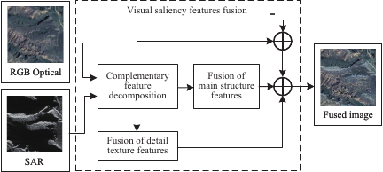
Fig. 3. Visual saliency features fusion.
Two fusion methods were designed for different data sources. Specifically, decomposition and feature fusion rules 25 were used to enhance the fusion of complementary information. A detailed workflow of the RGB optical images and SAR data is showed in Fig. 3.
The data were decomposed into a set of complementary features: the main structural features and detailed texture features. The source data and decomposed parts are defined as follows:
Next, the pixel saliency map and structure saliency map were extracted by fusing the main structural features. The fusion process is as follows:
Then, the detailed texture features from the optical and SAR images were fused, which were calculated as follows:
Finally, the color transformation method was used to transfer the spectral information, which was calculated as follows:
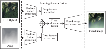
Fig. 4. Learning features fusion.
Inspired by U2Fusion 26, a fusion method for RGB optical images and DEM data was designed to fuse complementary information from different domains. The detailed workflow is showed in Fig. 4. The fusion process is as follows:
3.2. Remote Sensing Collaborative Monitoring
Remote sensing collaborative monitoring focuses on globalized and localized characteristics using information sourced from space-based and airborne technologies. This process involves extracting features from aerial and UAV data for integration with space-based information or directly applying space-based and airborne technologies to monitor hazardous areas.
Surface DEM construction and differencing further revealed topographic changes. Airborne technologies such as LiDAR point clouds generate 3D models. In general, airborne methods transcend the constraints of space-based imagery and capture detailed information.
The RGB optical images obtained through aerial photogrammetry compensate for the limitations of satellite remote sensing imagery. Analyzing the technical strengths, data collection, and processing procedures of UAV systems and extracting the parameters of spatial, geometric, and optical features allows for the effective monitoring of geological hazards. Intelligent control technologies combined with edge computing can be adopted to accommodate diverse application scenarios. The fusion formulation can be expressed as follows:
Space-based and airborne techniques can be combined with on-site verification. The integrated application of multiple technologies and multi-source information further enhances the accuracy and comprehensiveness of hazard monitoring, offering a technical pathway for analyzing the formation patterns of hazards.
3.3. Space-Air-Ground Integrated Monitoring
The space-air-ground integrated monitoring unit satellite coverage, high-resolution aerial observations, and continuous ground-based monitoring. This study conducted deformation monitoring and prediction of geological hazards based on the integration of multi-source data. First, high-precision deformation fields derived from time-series InSAR analysis were combined with on-site GNSS displacement measurements to generate spatiotemporally continuous landslide displacement time series, serving as the baseline for prediction 27. Concurrently, satellite imagery and UAV-derived DSMs have been incorporated to enhance the representation of surface details and landslide geomorphological structures, and to quantify surface changes 28. These multi-source spatial datasets were further integrated with key environmental driving factors, including rainfall and groundwater table variations, to construct a multi-dimensional spatiotemporal feature matrix encompassing the deformation behavior, geomorphic structure, and environmental triggers. Based on this matrix, a deep neural network model was trained to achieve both short- and medium-to-long-term landslide displacement predictions, thereby improving the accuracy of the warning and the robustness of stability assessments.
A multi-source heterogeneous information fusion method was used to develop an intelligent fusion model based on the space-air-ground integrated system for the collaborative dynamic monitoring of geological hazards. Employing optical imagery, InSAR, UAV-based photogrammetry, and wireless sensor networks enable complete process monitoring.
4. Intelligent Monitoring Algorithms
Intelligent monitoring algorithms can be categorized into intelligent hazard algorithms, intelligent spatiotemporal prediction algorithms, and intelligent real-time warning algorithms, as showed in Fig. 5. AI algorithms, with their powerful nonlinear fitting and adaptive learning capabilities, enable the intelligent monitoring of geological hazard trends through learning models.
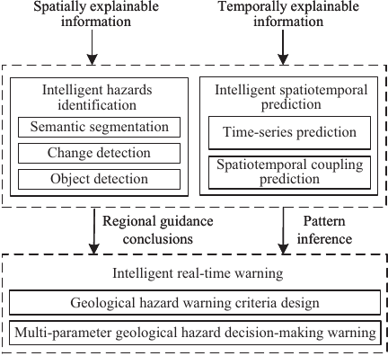
Fig. 5. Design of intelligent monitoring algorithms.
4.1. Intelligent Hazard Identification
Intelligent hazard identification algorithms extract information from images using computer vision-based multi-source data interpretation, identify potential hazards via deep learning, and broadly classify them using semantic segmentation, change detection, and object detection.
(1) Semantic segmentation
Semantic segmentation algorithms still face challenges such as boundary blurring and inaccurate feature extraction, making edge delineation difficult. Transformer-based U-Net (TransUNet) captures local details and the global context in geological hazard image segmentation with strong adaptability to complex topography 29. To address this challenge, improvements have been made to the TransUNet architecture by incorporating a vision encoder and a mask decoder, which are designed to enhance multi-scale feature extraction and facilitate the restoration of edge details, as shown in Fig. 6.
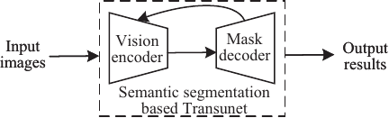
Fig. 6. Framework for semantic segmentation.
The vision encoder and mask decoder were designed to achieve semantic segmentation of geological hazard areas. The framework can be formulated as follows:
(2) Object detection
Object detection algorithms face limitations when dealing with complex backgrounds and multi-scale features, particularly with large variations in target orientation. YOLO has been widely applied in geological hazard object detection 30. YOLO-based detection models were improved by optimizing the network structure and framework for object detection under complex conditions have been developed, as shown in Fig. 7. For detailed detection in specific scenarios, UAVs are used to enhance the object detection performance, which effectively addresses the real-world challenges of complex backgrounds and small-target interference, improving the detection accuracy and reliability for small targets.
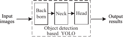
Fig. 7. Framework for object detection.
Employing object detection algorithms for area identification can predict the labels of target objects and their existence in the candidate regions of the input images, narrowing the focus of the original images. The framework can be formulated as follows:
(3) Change detection
One challenge in change detection for geological hazards is that the generation of large damaged pixel blocks makes it difficult for models to distinguish between actual hazards and hazard-like features. ResUnet was used to capture the large-scale spatial and temporal dependencies of hazard regions 31. An improved hybrid method based on ResUnet treats hazards as objects with multiple attribute information, extracting and modeling features from local elements at various scales and global information. Multi-temporal remote sensing images acquired before and after the hazard were compared to detect changes, as shown in Fig. 8.
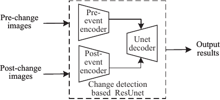
Fig. 8. Framework for change detection.
A model with two branches was designed to process the pre- and post-change images separately, and change detection was performed by comparing the resulting feature maps. The framework can be formulated as follows:
Intelligent hazard identification employs techniques such as semantic segmentation, change detection, and object detection, making full use of computer vision and deep learning to efficiently interpret multi-source remote sensing information. These algorithms not only improve identification accuracy and efficiency but also provide strong technical support for intelligent monitoring and real-time warning of geological hazards.
4.2. Intelligent Spatiotemporal Prediction
Predicting landslide displacement is a critical component of landslide hazard research. By analyzing temporal changes in landslide displacement, it is possible to predict future development trends. This landslide displacement prediction method was explored from two perspectives: time-series landslide displacement prediction and spatiotemporal coupled modeling landslide displacement prediction.
(1) Time-series landslide displacement prediction
Deep learning models based on time-series have been widely adopted because of their strong capacity to represent dynamic evolutionary processes. These approaches establish a predictive model by exploiting the correlations between historical displacements and exogenous driving factors. Typical model inputs include the cumulative displacement, precipitation, pore-water pressure, groundwater level, and surface temperature, all of which are incorporated as sequential covariates. Existing approaches that incorporate weighted moving average (WMA) decomposition with enhanced long short-term memory (LSTM) architectures have demonstrated significant improvements in prediction accuracy 32.
Building upon these decomposition–reconstruction frameworks, a multi-scale attention-enhanced temporal modeling paradigm has been widely adopted. In this paradigm, multi-scale convolutional operations and hierarchical attention mechanisms are used to capture both local and global dependencies within the displacement sequences. Furthermore, residual connections and dropout regularization were integrated to enhance the model stability and generalization capability, thereby achieving superior prediction accuracy and robustness in complex environmental scenarios. The overall workflow of the time-series prediction paradigm is shown in Fig. 9.
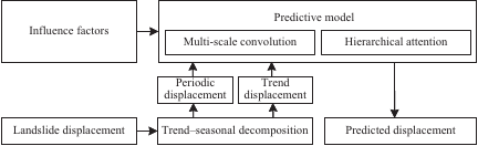
Fig. 9. Framework for the time-series landslide displacement prediction.
Within this time-series paradigm, let \(\mathbf{y}=\{y_t\}_{t=1}^{T}\) denote the cumulative displacement at a representative monitoring point. A generic decomposition operator \(\mathcal{D}_\phi\) such as a complete ensemble empirical mode decomposition with adaptive noise, variational mode decomposition, or singular spectrum analysis, maps \(\mathbf{y}\) into \(K\) components and a residual as follows:
For each component, multi-scale 1D convolutions with receptive fields \(\{s_\ell\}_{\ell=1}^{L}\) were applied as follows:
A hierarchical attention mechanism then fuses information across components and scales as follows:
The fused representation \(\widehat{\mathbf{h}}_t\) is then fed into a temporal prediction function \(f_{\theta}\) to obtain the future displacement as follows:
(2) Spatiotemporal coupled modeling for landslide displacement prediction
The core of spatiotemporal coupled modeling lies in the simultaneous characterization of spatial correlations between monitoring points and their time-evolving dynamic dependencies. By integrating sequential data, such as displacement observations and rainfall, into graph-structured network models, this approach synchronously captures the underlying propagation mechanisms and evolutionary trends of deformation within the spatiotemporal domain, thereby enabling the accurate prediction of landslide displacement. For multi-point landslide displacement prediction, methodologies based on graph deep learning and the T-GCN model, which combines a GRU with a GCN and an Attention-TGCN, have demonstrated high predictive accuracy and applicability in practical landslide case studies 33,34.
Building upon these foundations, recent studies have introduced learnable dynamic adjacency matrices and multi-head attention mechanisms to adaptively update the spatial connections between monitoring points and effectively capture non-stationary spatial dependencies. The overall framework of the dynamic spatiotemporal graph model is shown in Fig. 10.
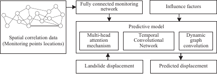
Fig. 10. Framework for the spatiotemporally coupled landslide displacement prediction.
Concurrently, temporal convolutional networks (TCNs) are incorporated to extend the receptive field for long-term sequence modeling. This integration aims to achieve superior cross-scenario generalization capability while concurrently enabling precise modeling of both step-like and gradual deformation patterns. Let \(\mathbf{X}_t\in\mathbb{R}^{N\times F}\) denote the multivariate features of \(N\) monitoring sites at time \(t\) and \(\mathbf{A}_t\in\mathbb{R}^{N\times N}\) be a dynamic adjacency matrix. A generic fusion of physical, data-driven, and attention-based graphs can be written as follows:
After normalization, spatial propagation is performed via graph convolution as follows:
The temporal module models the spatial feature sequence \(\mathbf{Z}_{t-w+1:t}\) of length \(w\) to obtain the hidden state \(\mathbf{H}_t\), and then predicts the displacement vector \(\widehat{\mathbf{y}}_{t+\tau} \in \mathbb{R}^N\) for all monitoring sites at time \(t+\tau\) as follows:
4.3. Intelligent Real-Time Warning
Intelligent real-time warnings are the ultimate goal of intelligent geological hazard monitoring. Based on the evolution of geological environments, real-time monitoring data and historical data were analyzed to issue geological hazard warnings in advance. The warning criteria were designed by integrating probabilistic relationships from multi-source information, and the thresholds were dynamically adjusted. The warning criterion can be expressed as follows:
The warning index can be defined as follows:
When \(R\) exceeded the dynamic threshold \(T_{\mathit{d}}\), a geological hazard warning was triggered. Based on the regional guidance conclusions and pattern inference of intelligent hazard identification and intelligent spatiotemporal prediction, a multi-parameter geological hazard decision-making warning system was constructed, which was applied to real-time data monitoring and warning generation.
5. Implementation of Monitoring System
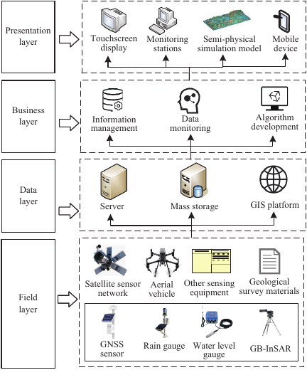
Fig. 11. Distributed system configuration.
An intelligent geological hazard monitoring system was implemented using a distributed space-air-ground integrated architecture. The following is an introduction to the system configuration and its practical application.
5.1. System Configuration
The system based on multi-source information fusion is divided into four layers, combining multi-platform collaborative to achieve hierarchical monitoring. The distributed system configuration is shown in Fig. 11.
The field layer consists of multi-source information acquisition modules, integrating space-, air-, and ground-based sensing to realize multi-scale and all-weather monitoring.
The data layer manages and stores data collected from the monitoring points. It includes functions such as the acquisition, storage, and processing of monitoring data. Data received from the device-end servers were preprocessed using a geographic information systems (GIS) platform and stored in the storage center database.
The business layer includes information management, data monitoring, and algorithm development, which processes, analyzes, and predicts data, identifies hazard regions, issues warnings, and maintains data exchange and coordination with the data layer.
The presentation layer provides real-time depictions of hazard areas, visualization of data from multiple sensors, displays of monitoring components, and warning management functions, including web and mobile applications.
5.2. Practical Applications
Two case studies of landslide identification using a deep learning method and an integrated intelligent monitoring system are presented below.
(1) Landslide identification based on segmentation network
Landslides were classified according to their occurrence time and characteristics into new landslides from Bijie City, Guizhou Province, China, and old landslides from Enshi Prefecture, Hubei Province, China. The landslides in Bijie City were identified using a model that improved U-Net 35. A landslide identification method based on an integrated segmentation network and transfer learning was proposed to address the difficulties with indistinct optical features and improve the accuracy for small sample sizes. The accuracy of the proposed method reached 91.60%, the recall reached 65.49%, and the F1 score reached 62.77%. Experimental results demonstrated that the proposed method achieved improvements in segmentation tasks 36.
(2) Intelligent monitoring and dynamic warning system for geological hazards
An intelligent monitoring system for geological hazards was developed for the Zigui–Badong region in the Three Gorges area, China to enable real-time monitoring and warnings. It integrates multi-source data and supports storage, management, analysis, and visualization through PC and mobile platforms. TCP protocols are used in portions of the area for warning simulations through semi-physical model-database interactions. Utilizing a GIS platform, the system facilitates efficient data processing and predictive model optimization. Deployed in Yichang, Hubei, and Qingyuan, Guangdong, it covers 136 monitoring sites with 733 sensors and provides reliable data and decision-making support for geological hazards 37.
5.3. System Functional Results
This system ensures comprehensive spatiotemporal coverage by integrating space-, air-, and ground-based observations within a unified architecture that overcomes the limited scope of single-source systems. The representative results of typical application scenarios are presented.
The intelligent hazard identification functions are shown in Fig. 12. The spatial extent and morphology of the hazards were captured, indicating that the system provided spatial information.
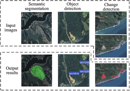
Fig. 12. Results of intelligent hazard identification.
The function of intelligent displacement prediction is shown in Fig. 13. The predicted time-series followed the observed displacement evolution for several monitoring points, demonstrating that time-series landslide displacement prediction and spatiotemporal coupled modeling for landslide displacement prediction are effective in characterizing the spatiotemporal dynamics of displacement.
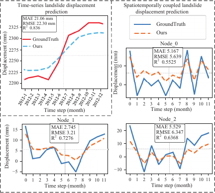
Fig. 13. Results of intelligent displacement prediction.
6. Conclusion
This study begins with the three core aspects of intelligent hazard identification, intelligent spatiotemporal prediction, and intelligent real-time warning, analyzing the technical characteristics of space-based, airborne, and ground-based information, exploring fusion methods for geological hazards at different scales, and discussing the application of deep learning algorithms. However, information is heterogeneous with complex interactions, and information loss occurs during the fusion process. Intelligent algorithms have restricted generalization in complex geological environments for practical applications. Therefore, future work should explore more advanced technologies using integrated satellites and unmanned systems with edge computing to build more intelligent monitoring platforms and extend them to diverse multi-hazard scenarios for hazard prevention and control in high-risk areas.
Acknowledgments
This study was supported in part by the Technological Innovation Project of Hubei Province under Grant 2024BCB067, the 111 Project under Grant B17040, and the Fundamental Research Funds for the Central Universities, China University of Geosciences.
- [1] P. Ward, V. Blauhut, N. Bloemendaal, J. Daniell, M. de Ruiter, M. Duncan, R. Emberson, S. Jenkins, D. Kirschbaum, M. Kunz, S. Mohr, S. Muis, G. Riddell, A. Schäfer, T. Stanley, T. Veldkamp, and H. Winsemius, “Review article: Natural hazard risk assessments at the global scale,” Natural Hazards and Earth System Sciences, Vol.20, pp. 1069-1096, 2020. https://doi.org/10.5194/nhess-20-1069-2020
- [2] Y. Fu, H. Zhong, and C. Fang, “Attention U-Mamba: A simple and efficient method for landslide segmentation,” IEEE Geoscience and Remote Sensing Letters, Vol.22, pp. 1-5, 2025. https://doi.org/10.1109/LGRS.2025.3580565
- [3] Y. Qu, H. Xing, L. Sun, X. Shi, J. Huang, Z. Ao, Z. Chang, and J. Li, “Integrating sentinel-2a imagery, DEM data, and spectral feature analysis for landslide detection via fully convolutional networks,” Landslides, Vol.22, pp. 335-352, 2025. https://doi.org/10.1007/s10346-024-02379-6
- [4] L. Bu, J. Zhang, Z. Zhang, Y. Yang, and M. Deng, “Deep learning for integrated speckle reduction and super-resolution in multi-temporal SAR,” Remote Sensing, Vol.16, Article No.18, 2024. https://doi.org/10.3390/rs16010018
- [5] R. Pattanaik and Y. Singh, “Study on characteristics and impact of Kalikhola landslide, Manipur, NE India, using UAV photogrammetry,” Natural Hazards, Vol.120, pp. 6417-6435, 2024. https://doi.org/10.1007/s11069-024-06484-6
- [6] D. Curzio, A. Castrignanò, S. Fountas, M. Romić, and R. Rossel, “Multi-source data fusion of big spatial-temporal data in soil, geo-engineering and environmental studies,” Science of The Total Environment, Vol.788, Article No.147842, 2021. https://doi.org/10.1016/j.scitotenv.2021.147842
- [7] J. Dou, K. Xing, Z. Lu, B. Peng, Y. Peng, and F. Guo, “Comprehensive analysis of July 17, 2024, heavy rainfall-induced landslide at Zigui County in the Three Gorges Reservoir Area, China,” Landslides, Vol.22, pp. 957-965, 2025. https://doi.org/10.1007/s10346-024-02442-2
- [8] L. Zhang, R. Zhang, J. Dou, S. Hou, Z. Xiang, H. Wang, P. Yang, and X. Liu, “Advancing reservoir landslide stability assessment via TS-InSAR and airborne LiDAR observations in the daping landslide group, Three Gorges Reservoir Area, China,” Landslides, Vol.22, pp. 169-188, 2025. https://doi.org/10.1007/s10346-024-02337-2
- [9] W. Li and C. Hsu, “GeoAI for large-scale image analysis and machine vision: Recent progress of artificial intelligence in geography,” ISPRS Int. J. of Geo-Information, Vol.11, No.7, Article No.385, 2022. https://doi.org/10.3390/ijgi11070385
- [10] M. Binetti, C. Massarelli, and V. Uricchio, “Machine learning in geosciences: A review of complex environmental monitoring applications,” Machine Learning and Knowledge Extraction, Vol.6, No.2, pp. 1263-1280, 2024. https://doi.org/10.3390/make6020059
- [11] Z. Ma and G. Mei, “Deep learning for geological hazards analysis: Data, models, applications, and opportunities,” Earth-Science Reviews, Vol.223, Article No.103858, 2021. https://doi.org/10.1016/j.earscirev.2021.103858
- [12] K. Dai, Z. Li, Q. Xu, R. Bürgmann, D. Milledge, and R. Tomás, “Entering the era of earth observation-based landslide warning systems: A novel and exciting framework,” IEEE Geoscience and Remote Sensing Magazine, Vol.8, No.1, pp. 136-153, 2020. https://doi.org/10.1109/MGRS.2019.2954395
- [13] X. Zhu, H. Xi, Z. He, and Y. Liu, “An intelligent wireless displacement sensor for landslide monitoring and early warning,” IOP Conf. Series: Earth and Environmental Science, Vol.861, Article No.072038, 2021. https://doi.org/10.1088/1755-1315/861/7/072038
- [14] M. Chen, Z. Cai, Y. Zeng, and Y. Yu, “Multi-sensor data fusion technology for the early landslide warning system,” J. of Ambient Intelligence and Humanized Computing, Vol.14, pp. 11165-11172, 2023. https://doi.org/10.1007/s12652-022-04396-6
- [15] Q. Xu, D. Peng, S. Zhang, X. Zhu, C. He, X. Qi, K. Zhao, D. Xiu, and N. Ju, “Successful implementations of a real-time and intelligent early warning system for loess landslides on the Heifangtai terrace, China,” Engineering Geology, Vol.278, Article No.105817, 2020. https://doi.org/10.1016/j.enggeo.2020.105817
- [16] W. Li, I. Ivan, Y. Liu, and L. Yang, “Visual processing and analysis of landslide deformation based on GNSS,” IEEE Sensors J., Vol.21, No.22, pp. 25260-25266, 2021. https://doi.org/10.1109/JSEN.2021.3061256
- [17] E. Schönfeldt, D. Winocur, T. Pánek, and O. Korup, “Deep learning reveals one of Earth’s largest landslide terrain in Patagonia,” Earth and Planetary Science Letters, Vol.593, Article No.117642, 2022. https://doi.org/10.1016/j.epsl.2022.117642
- [18] T. Shao, Z. Zheng, Y. He, W. Huang, and C. Xie, “Monitoring geological hazards with InSAR,” IEEE Int. Geoscience and Remote Sensing Symp. (IGARSS 2022), 2022. https://doi.org/10.1109/IGARSS46834.2022.9884003
- [19] B. Chen, J. Maurer, and W. Gong, “Applications of UAV in landslide research: A review,” Landslides, Vol.22, pp. 3029-3048, 2025. https://doi.org/10.1007/s10346-025-02547-2
- [20] D. Godone, P. Allasia, L. Borrelli, and G. Gullà, “UAV and structure from motion approach to monitor the Maierato landslide evolution,” Remote Sensing, Vol.12, Article No.1039, 2020. https://doi.org/10.3390/rs12061039
- [21] A. Kyriou and K. Nikolakopoulos, “Landslide mapping using optical and radar data: A case study from Aminteo, Western Macedonia, Greece,” European J. of Remote Sensing, Vol.53, pp. 17-27, 2020. https://doi.org/10.1080/22797254.2019.1681905
- [22] Q. Lin, Z. Yang, J. Huang, J. Deng, L. Chen, and Y. Zhang, “A landslide displacement prediction model based on the ICEEMDAN method and the TCN–BiLSTM combined neural network,” Water, Vol.15, Article No.4247, 2023. https://doi.org/10.3390/w15244247
- [23] C. Hu, Y. Deng, W. Tian, J. Wang, and T. Zeng, “Novel MIMO-SAR system applied for high-speed and high accuracy deformation measurement,” The J. of Engineering, Vol.2019, No.20, pp. 6598-6602, 2019. https://doi.org/10.1049/joe.2019.0290
- [24] W. Nie, C. Tian, D. Song, X. Liu, and E. Wang, “Disaster process and multisource information monitoring and warning method for rainfall-triggered landslide: A case study in the southeastern coastal area of China,” Natural Hazards, Vol.121, pp. 2535-2564, 2025. https://doi.org/10.1007/s11069-024-06897-3
- [25] X. Gong, Z. Hou, A. Ma, Y. Zhong, M. Zhang, and K. Lv, “An adaptive multiscale Gaussian co-occurrence filtering decomposition method for multispectral and SAR image fusion,” IEEE J. of Selected Topics in Applied Earth Observations and Remote Sensing, Vol.16, pp. 8215-8229, 2023. https://doi.org/10.1109/JSTARS.2023.3296505
- [26] H. Xu, J. Ma, J. Jiang, X. Guo, and H. Ling, “U2Fusion: A unified unsupervised image fusion network,” IEEE Trans. on Pattern Analysis and Machine Intelligence, Vol.44, No.1, pp. 502-518, 2022. https://doi.org/10.1109/TPAMI.2020.3012548
- [27] A. Parizzi, F. Gonzalez, and R. Brcic, “A covariance-based approach to merging InSAR and GNSS displacement rate measurements,” Remote Sensing, Vol.12, Article No.300, 2020. https://doi.org/10.3390/rs12020300
- [28] K. Nikolakopoulos, A. Kyriou, I. Koukouvelas, N. Tomaras, and E. Lyros, “UAV, GNSS, and InSAR data analyses for landslide monitoring in a mountainous village in western Greece,” Remote Sensing, Vol.15, Article No.2870, 2023. https://doi.org/10.3390/rs15112870
- [29] J. Chen, Y. Lu, Q. Yu, X. Luo, E. Adeli, Y. Wang, L. Lu, A. Yuille, and Y. Zhou, “TransUNet: Transformers make strong encoders for medical image segmentation,” arXiv:2102.04306, 2021. https://doi.org/10.48550/arXiv.2102.04306
- [30] Y. Yang, Z. Miao, H. Zhang, B. Wang, and L. Wu, “Lightweight attention-guided YOLO with level set layer for landslide detection from optical satellite images,” IEEE J. of Selected Topics in Applied Earth Observations and Remote Sensing, Vol.17, pp. 3543-3559, 2024. https://doi.org/10.1109/jstars.2024.3351277
- [31] X. Zhang, W. Yu, M. Pun, and W. Shi, “Cross-domain landslide mapping from large-scale remote sensing images using prototype-guided domain-aware progressive representation learning,” ISPRS J. of Photogrammetry and Remote Sensing, Vol.197, pp. 1-17, 2023. https://doi.org/10.1016/j.isprsjprs.2023.01.018
- [32] Z. Lin, X. Sun, and Y. Ji, “Landslide displacement prediction model using time series analysis method and modified LSTM model,” Electronics, Vol.11, Article No.1519, 2022. https://doi.org/10.3390/electronics11101519
- [33] C. Yang, Y. Yin, J. Zhang, P. Ding, and J. Liu, “A graph deep learning method for landslide displacement prediction based on global navigation satellite system positioning,” Geoscience Frontiers, Vol.15, Article No.101690, 2024. https://doi.org/10.1016/j.gsf.2023.101690
- [34] Y. Sun, T. Liu, C. Zhang, N. Xi, and H. Wang, “Spatiotemporal prediction of landslide displacement using graph convolutional network-based models: A case study of the Tangjiao 1# landslide in Chongqing,” Applied Sciences, Vol.14, Article No.9288, 2024. https://doi.org/10.3390/app14209288
- [35] H. Qu, C. Lu, Y. Pan, Y. Zeng, and M. Wu, “Semantic segmentation of historical landslide based on improved U-Net,” 2023 42nd Chinese Control Conf. (CCC), 2023. https://doi.org/10.23919/CCC58697.2023.10240652
- [36] S. Chen, H. Qu, Y. Shao, Y. Zeng, Z. Wu, C. Lu, and M. Wu, “A landslide identification method based on integrated segmentation network and transfer learning,” Neurocomputing, Vol.653, Article No.131242, 2025. https://doi.org/10.1016/j.neucom.2025.131242
- [37] Y. Pan, C. Lu, W. Yu, and M. Wu, “Design and application of intelligent monitoring system for geological hazards,” 2022 41st Chinese Control Conf. (CCC), 2022. https://doi.org/10.23919/CCC55666.2022.9902700
This article is published under a Creative Commons Attribution-NoDerivatives 4.0 Internationa License.