Research Paper:
Space-Air-Ground Integrated Intelligent Monitoring System for Geological Hazards Based on Multi-Source Information Fusion Technology
Sijing Chen*1, Yunyan Shao*1, Zikang Wu*2,*3,*4, Chengda Lu*2,*3,*4, and Min Wu*1,*2,*3,*4,†
*1School of Future Technology, China University of Geosciences
No.388 Lumo Road, Hongshan, Wuhan 430074, China
*2School of Artificial Intelligence and Automation, China University of Geosciences
No.388 Lumo Road, Hongshan, Wuhan 430074, China
*3Hubei Key Laboratory of Advanced Control and Intelligent Automation for Complex Systems
No.388 Lumo Road, Hongshan, Wuhan 430074, China
*4Engineering Research Center of Intelligent Technology for Geo-Exploration, Ministry of Education
No.388 Lumo Road, Hongshan, Wuhan 430074, China
†Corresponding author

Geological hazards exhibit strong abruptness and severe destructive effects, frequently occur worldwide, and pose a serious threat to human life and property. Conventional methods for geological hazard monitoring are inadequate for fulfilling the requirements of accurate and real-time monitoring under complex geological conditions. This study provides an intelligent system for geological hazard monitoring based on multi-source information fusion. The characteristics of space-based, airborne, and ground-based multi-source information were analyzed. Multi-source information fusion methods at different scales were also discussed. Subsequently, intelligent algorithms for hazard identification, spatiotemporal prediction, and real-time warnings in the field of geological hazard monitoring were explored. Furthermore, practical application cases of the system were presented, laying a foundation for research on the application of artificial intelligence to geological hazards.
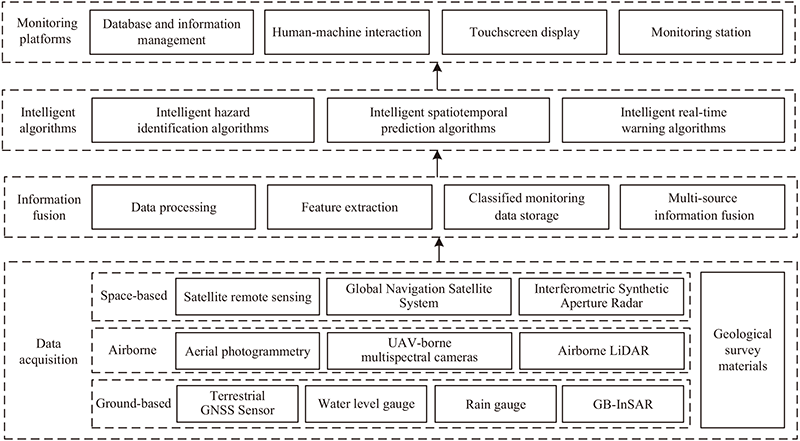
Overall architecture of geological hazard monitoring
- [1] P. Ward, V. Blauhut, N. Bloemendaal, J. Daniell, M. de Ruiter, M. Duncan, R. Emberson, S. Jenkins, D. Kirschbaum, M. Kunz, S. Mohr, S. Muis, G. Riddell, A. Schäfer, T. Stanley, T. Veldkamp, and H. Winsemius, “Review article: Natural hazard risk assessments at the global scale,” Natural Hazards and Earth System Sciences, Vol.20, pp. 1069-1096, 2020. https://doi.org/10.5194/nhess-20-1069-2020
- [2] Y. Fu, H. Zhong, and C. Fang, “Attention U-Mamba: A simple and efficient method for landslide segmentation,” IEEE Geoscience and Remote Sensing Letters, Vol.22, pp. 1-5, 2025. https://doi.org/10.1109/LGRS.2025.3580565
- [3] Y. Qu, H. Xing, L. Sun, X. Shi, J. Huang, Z. Ao, Z. Chang, and J. Li, “Integrating sentinel-2a imagery, DEM data, and spectral feature analysis for landslide detection via fully convolutional networks,” Landslides, Vol.22, pp. 335-352, 2025. https://doi.org/10.1007/s10346-024-02379-6
- [4] L. Bu, J. Zhang, Z. Zhang, Y. Yang, and M. Deng, “Deep learning for integrated speckle reduction and super-resolution in multi-temporal SAR,” Remote Sensing, Vol.16, Article No.18, 2024. https://doi.org/10.3390/rs16010018
- [5] R. Pattanaik and Y. Singh, “Study on characteristics and impact of Kalikhola landslide, Manipur, NE India, using UAV photogrammetry,” Natural Hazards, Vol.120, pp. 6417-6435, 2024. https://doi.org/10.1007/s11069-024-06484-6
- [6] D. Curzio, A. Castrignanò, S. Fountas, M. Romić, and R. Rossel, “Multi-source data fusion of big spatial-temporal data in soil, geo-engineering and environmental studies,” Science of The Total Environment, Vol.788, Article No.147842, 2021. https://doi.org/10.1016/j.scitotenv.2021.147842
- [7] J. Dou, K. Xing, Z. Lu, B. Peng, Y. Peng, and F. Guo, “Comprehensive analysis of July 17, 2024, heavy rainfall-induced landslide at Zigui County in the Three Gorges Reservoir Area, China,” Landslides, Vol.22, pp. 957-965, 2025. https://doi.org/10.1007/s10346-024-02442-2
- [8] L. Zhang, R. Zhang, J. Dou, S. Hou, Z. Xiang, H. Wang, P. Yang, and X. Liu, “Advancing reservoir landslide stability assessment via TS-InSAR and airborne LiDAR observations in the daping landslide group, Three Gorges Reservoir Area, China,” Landslides, Vol.22, pp. 169-188, 2025. https://doi.org/10.1007/s10346-024-02337-2
- [9] W. Li and C. Hsu, “GeoAI for large-scale image analysis and machine vision: Recent progress of artificial intelligence in geography,” ISPRS Int. J. of Geo-Information, Vol.11, No.7, Article No.385, 2022. https://doi.org/10.3390/ijgi11070385
- [10] M. Binetti, C. Massarelli, and V. Uricchio, “Machine learning in geosciences: A review of complex environmental monitoring applications,” Machine Learning and Knowledge Extraction, Vol.6, No.2, pp. 1263-1280, 2024. https://doi.org/10.3390/make6020059
- [11] Z. Ma and G. Mei, “Deep learning for geological hazards analysis: Data, models, applications, and opportunities,” Earth-Science Reviews, Vol.223, Article No.103858, 2021. https://doi.org/10.1016/j.earscirev.2021.103858
- [12] K. Dai, Z. Li, Q. Xu, R. Bürgmann, D. Milledge, and R. Tomás, “Entering the era of earth observation-based landslide warning systems: A novel and exciting framework,” IEEE Geoscience and Remote Sensing Magazine, Vol.8, No.1, pp. 136-153, 2020. https://doi.org/10.1109/MGRS.2019.2954395
- [13] X. Zhu, H. Xi, Z. He, and Y. Liu, “An intelligent wireless displacement sensor for landslide monitoring and early warning,” IOP Conf. Series: Earth and Environmental Science, Vol.861, Article No.072038, 2021. https://doi.org/10.1088/1755-1315/861/7/072038
- [14] M. Chen, Z. Cai, Y. Zeng, and Y. Yu, “Multi-sensor data fusion technology for the early landslide warning system,” J. of Ambient Intelligence and Humanized Computing, Vol.14, pp. 11165-11172, 2023. https://doi.org/10.1007/s12652-022-04396-6
- [15] Q. Xu, D. Peng, S. Zhang, X. Zhu, C. He, X. Qi, K. Zhao, D. Xiu, and N. Ju, “Successful implementations of a real-time and intelligent early warning system for loess landslides on the Heifangtai terrace, China,” Engineering Geology, Vol.278, Article No.105817, 2020. https://doi.org/10.1016/j.enggeo.2020.105817
- [16] W. Li, I. Ivan, Y. Liu, and L. Yang, “Visual processing and analysis of landslide deformation based on GNSS,” IEEE Sensors J., Vol.21, No.22, pp. 25260-25266, 2021. https://doi.org/10.1109/JSEN.2021.3061256
- [17] E. Schönfeldt, D. Winocur, T. Pánek, and O. Korup, “Deep learning reveals one of Earth’s largest landslide terrain in Patagonia,” Earth and Planetary Science Letters, Vol.593, Article No.117642, 2022. https://doi.org/10.1016/j.epsl.2022.117642
- [18] T. Shao, Z. Zheng, Y. He, W. Huang, and C. Xie, “Monitoring geological hazards with InSAR,” IEEE Int. Geoscience and Remote Sensing Symp. (IGARSS 2022), 2022. https://doi.org/10.1109/IGARSS46834.2022.9884003
- [19] B. Chen, J. Maurer, and W. Gong, “Applications of UAV in landslide research: A review,” Landslides, Vol.22, pp. 3029-3048, 2025. https://doi.org/10.1007/s10346-025-02547-2
- [20] D. Godone, P. Allasia, L. Borrelli, and G. Gullà, “UAV and structure from motion approach to monitor the Maierato landslide evolution,” Remote Sensing, Vol.12, Article No.1039, 2020. https://doi.org/10.3390/rs12061039
- [21] A. Kyriou and K. Nikolakopoulos, “Landslide mapping using optical and radar data: A case study from Aminteo, Western Macedonia, Greece,” European J. of Remote Sensing, Vol.53, pp. 17-27, 2020. https://doi.org/10.1080/22797254.2019.1681905
- [22] Q. Lin, Z. Yang, J. Huang, J. Deng, L. Chen, and Y. Zhang, “A landslide displacement prediction model based on the ICEEMDAN method and the TCN–BiLSTM combined neural network,” Water, Vol.15, Article No.4247, 2023. https://doi.org/10.3390/w15244247
- [23] C. Hu, Y. Deng, W. Tian, J. Wang, and T. Zeng, “Novel MIMO-SAR system applied for high-speed and high accuracy deformation measurement,” The J. of Engineering, Vol.2019, No.20, pp. 6598-6602, 2019. https://doi.org/10.1049/joe.2019.0290
- [24] W. Nie, C. Tian, D. Song, X. Liu, and E. Wang, “Disaster process and multisource information monitoring and warning method for rainfall-triggered landslide: A case study in the southeastern coastal area of China,” Natural Hazards, Vol.121, pp. 2535-2564, 2025. https://doi.org/10.1007/s11069-024-06897-3
- [25] X. Gong, Z. Hou, A. Ma, Y. Zhong, M. Zhang, and K. Lv, “An adaptive multiscale Gaussian co-occurrence filtering decomposition method for multispectral and SAR image fusion,” IEEE J. of Selected Topics in Applied Earth Observations and Remote Sensing, Vol.16, pp. 8215-8229, 2023. https://doi.org/10.1109/JSTARS.2023.3296505
- [26] H. Xu, J. Ma, J. Jiang, X. Guo, and H. Ling, “U2Fusion: A unified unsupervised image fusion network,” IEEE Trans. on Pattern Analysis and Machine Intelligence, Vol.44, No.1, pp. 502-518, 2022. https://doi.org/10.1109/TPAMI.2020.3012548
- [27] A. Parizzi, F. Gonzalez, and R. Brcic, “A covariance-based approach to merging InSAR and GNSS displacement rate measurements,” Remote Sensing, Vol.12, Article No.300, 2020. https://doi.org/10.3390/rs12020300
- [28] K. Nikolakopoulos, A. Kyriou, I. Koukouvelas, N. Tomaras, and E. Lyros, “UAV, GNSS, and InSAR data analyses for landslide monitoring in a mountainous village in western Greece,” Remote Sensing, Vol.15, Article No.2870, 2023. https://doi.org/10.3390/rs15112870
- [29] J. Chen, Y. Lu, Q. Yu, X. Luo, E. Adeli, Y. Wang, L. Lu, A. Yuille, and Y. Zhou, “TransUNet: Transformers make strong encoders for medical image segmentation,” arXiv:2102.04306, 2021. https://doi.org/10.48550/arXiv.2102.04306
- [30] Y. Yang, Z. Miao, H. Zhang, B. Wang, and L. Wu, “Lightweight attention-guided YOLO with level set layer for landslide detection from optical satellite images,” IEEE J. of Selected Topics in Applied Earth Observations and Remote Sensing, Vol.17, pp. 3543-3559, 2024. https://doi.org/10.1109/jstars.2024.3351277
- [31] X. Zhang, W. Yu, M. Pun, and W. Shi, “Cross-domain landslide mapping from large-scale remote sensing images using prototype-guided domain-aware progressive representation learning,” ISPRS J. of Photogrammetry and Remote Sensing, Vol.197, pp. 1-17, 2023. https://doi.org/10.1016/j.isprsjprs.2023.01.018
- [32] Z. Lin, X. Sun, and Y. Ji, “Landslide displacement prediction model using time series analysis method and modified LSTM model,” Electronics, Vol.11, Article No.1519, 2022. https://doi.org/10.3390/electronics11101519
- [33] C. Yang, Y. Yin, J. Zhang, P. Ding, and J. Liu, “A graph deep learning method for landslide displacement prediction based on global navigation satellite system positioning,” Geoscience Frontiers, Vol.15, Article No.101690, 2024. https://doi.org/10.1016/j.gsf.2023.101690
- [34] Y. Sun, T. Liu, C. Zhang, N. Xi, and H. Wang, “Spatiotemporal prediction of landslide displacement using graph convolutional network-based models: A case study of the Tangjiao 1# landslide in Chongqing,” Applied Sciences, Vol.14, Article No.9288, 2024. https://doi.org/10.3390/app14209288
- [35] H. Qu, C. Lu, Y. Pan, Y. Zeng, and M. Wu, “Semantic segmentation of historical landslide based on improved U-Net,” 2023 42nd Chinese Control Conf. (CCC), 2023. https://doi.org/10.23919/CCC58697.2023.10240652
- [36] S. Chen, H. Qu, Y. Shao, Y. Zeng, Z. Wu, C. Lu, and M. Wu, “A landslide identification method based on integrated segmentation network and transfer learning,” Neurocomputing, Vol.653, Article No.131242, 2025. https://doi.org/10.1016/j.neucom.2025.131242
- [37] Y. Pan, C. Lu, W. Yu, and M. Wu, “Design and application of intelligent monitoring system for geological hazards,” 2022 41st Chinese Control Conf. (CCC), 2022. https://doi.org/10.23919/CCC55666.2022.9902700
This article is published under a Creative Commons Attribution-NoDerivatives 4.0 Internationa License.