
Paper:
A City-Ready Framework for Urban Flood Resilience in Surabaya Integrating Spatial Exposure and Social Capacity
Bambang Sigit Widodo*1,†
 , Dian Ayu Larasati*2
, Riyadi*2
, Heni Masruroh*3
, Alfi Sahrina*3
, Adib Wahyudi*3
, Rath Sethik*4
, and Enoch Terlumun Iortyom*5
, Dian Ayu Larasati*2
, Riyadi*2
, Heni Masruroh*3
, Alfi Sahrina*3
, Adib Wahyudi*3
, Rath Sethik*4
, and Enoch Terlumun Iortyom*5
*1State University of Surabaya
Lidah Wetan Street, Surabaya, East Java 60213, Indonesia
†Corresponding author
*2State University of Surabaya
Surabaya, Indonesia
*3State University of Malang
Malang, Indonesia
*4Royal University of Phnom Penh
Phnom Penh, Cambodia
*5Ernest Bai Koroma University of Science and Technology
Magburaka, Sierra Leone

Urban flooding threatens service continuity, livelihoods, and social well-being in coastal megacities. We propose and test a framework that integrates high-resolution, Geographic Information System-based exposure mapping (inundation hotspots, drainage proximity, land cover, and critical facilities) with community-level capacity indicators (preparedness, adaptive capacity, and recovery) derived from a mixed-methods design. Using routinely available spatial data and rapid community assessment, we generate a composite index of flood resilience, identify chronic ponding clusters, and prioritize low-regret interventions. Results reveal spatially coherent hotspots that coincide with high built-up density and limited adaptive capacity; neighborhoods with weaker social preparedness also report longer recovery times. A short list of interventions, including micro-drain maintenance, targeted blue–green retrofits near drainage bottlenecks, and neighborhood-level early-warning and risk communication, offers achievable near-term impact within realistic municipal resource constraints. Sensitivity checks indicate index stability with respect to weighting choices. The approach is transferable to other flood-prone cities by coupling GIS layers with community metrics, providing a transparent basis for investment sequencing and policy design. Findings highlight that combining exposure and capacity yields more actionable prioritization than either dimension alone and aligns with global disaster risk reduction principles.
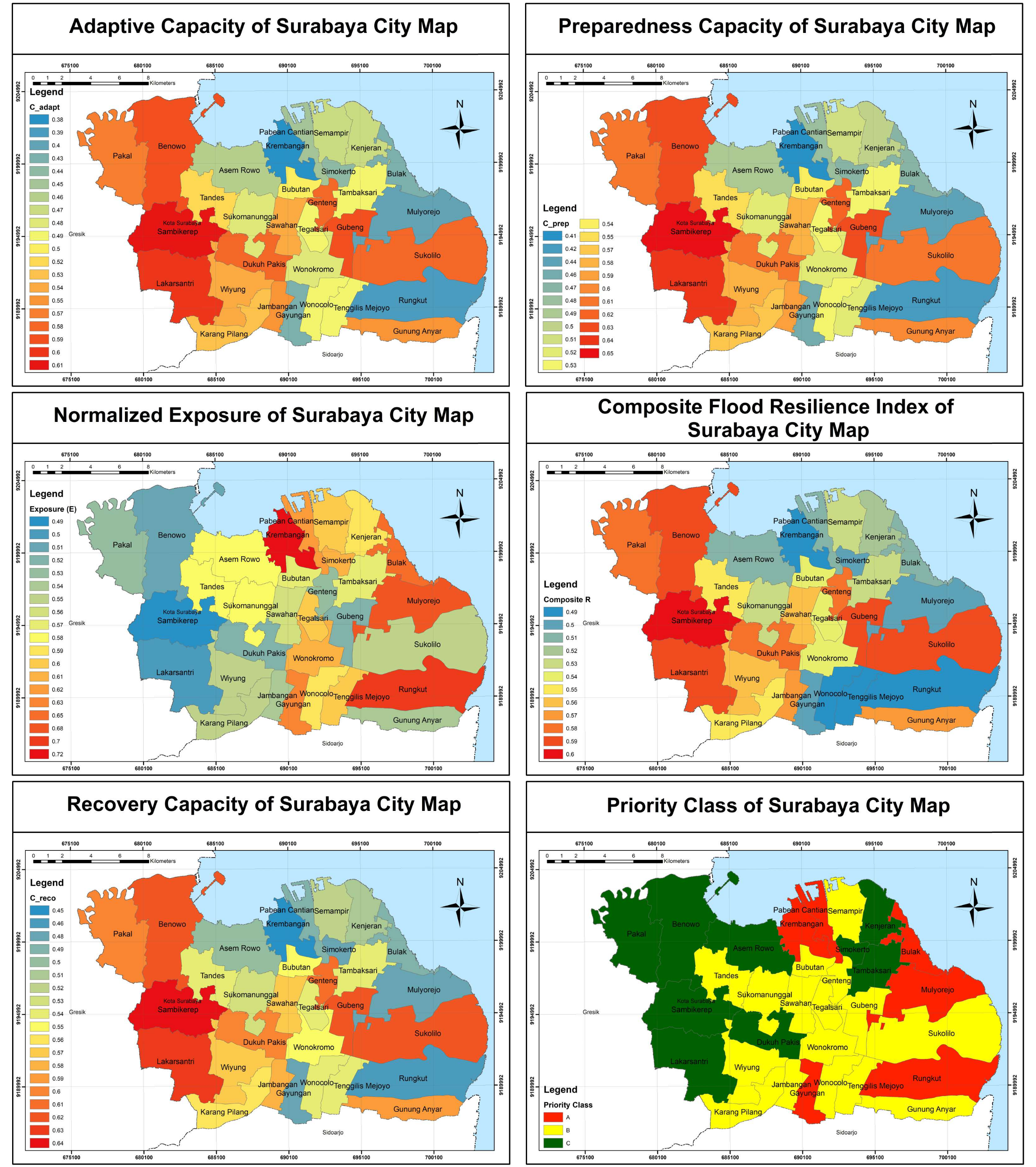
Surabaya City priority class map
- [1] J. Boguniewicz-Zabłocka and E. Łukasiewicz, “Blue–green infrastructure effectiveness for urban stormwater management: A multi-scale residential case study,” Land, Vol.14, Issue 7, Article No.1340, 2025. https://doi.org/10.3390/land14071340
- [2] J. DeSapio, “Transformational learning: A literature review of recent criticism,” J. of Transformative Learning, Vol.4, No.2, pp. 56-63, 2018.
- [3] A. D. P. Mas, “Study on flood management plan in SUrabaya City,” J. Civ. Eng. Forum., Vol.1, No.2, 2017. https://doi.org/10.22146/jcef.23891
- [4] C. N. Yuanita and S. Sagala, “Blue-green infrastructure in Jakarta’s fringe: An analysis of accessibility to blue-green spaces as a flood solution in Bekasi City,” Int. J. Disaster Risk Reduct., Vol.121, Article No.105425, 2025. https://doi.org/10.1016/j.ijdrr.2025.105425
- [5] R. D’Ambrosio, V. Foresta, A. Longobardi, and S. Ferlisi, “Exploring the role of pedological and climatic aspects in the medium-term decline of green roofs hydrological performance: An experimental study in a Mediterranean environment,” Blue-Green Syst., Vol.6, No.2, pp. 293-309, 2024. https://doi.org/10.2166/bgs.2024.021
- [6] D. Bhandari, “Challenges and opportunities in Nepal’s early warning communication,” Int. J. Disaster Risk Reduct., Vol.119, Article No.105318, 2025. https://doi.org/10.1016/j.ijdrr.2025.105318
- [7] S. Soleh and M. Sofyan, “Social impact management assessment of urban flood is important-especially in Surabaya-Wonokromo and Surabaya-Brangkal,” Ilomata Int. J. Soc. Sci., Vol.1, No.2, pp. 69-76, 2020. https://doi.org/10.52728/ijss.v1i2.80
- [8] S. Ali and A. George, “Modelling a community resilience index for urban flood-prone areas of Kerala, India (CRIF),” Nat. Hazards, Vol.113, No.1, pp. 261-286, 2022. https://doi.org/10.1007/s11069-022-05299-7
- [9] K. Phommavong, J. Yan, S. A. Shah, and C. Chisenga, “Assessment of flood risk in Northern and Southern Laos using geospatial data,” Geomat., Nat. Hazards Risk, Vol.16, Issue 1, Article No.2537859, 2025. https://doi.org/10.1080/19475705.2025.2537859
- [10] S. Pramono, S. Roekminiati, and A. V. Vitianingsih, “Effectiveness of flood management through pump houses based on geographic information systems in the city of Surabaya,” Proc. of the Int. Conf. of Public Administration and Governance (ICOPAG 2022), pp. 349-368, 2023. https://doi.org/10.2991/978-2-38476-082-4_32
- [11] P. Dang, J. Zhu, C. Dang, and H. Zhang, “A method for assessing urban flood impacts by combining hydrodynamic models with entity semantic evolution,” Int. J. Digital Earth, Vol.18, Issue 1, Article No.2515268, 2025. https://doi.org/10.1080/17538947.2025.2515268
- [12] S. Arikunto, “Prosedur Penelitian Suatu Pendekatan Praktik,” Rineka Cipta, 2010 (in Indonesian).
- [13] N. Liu and F. Zhang, “Urban green spaces and flood disaster management: Toward sustainable urban design,” Frontiers Public Health, Vol.13, Article No.1583978, 2025. https://doi.org/10.3389/fpubh.2025.1583978
- [14] J. Cachay, J. Wennemer, E. Abele, and R. Tenberg, “Study on action-oriented learning with a learning factory approach,” Procedia - Soc. Behav. Sci., Vol.55, pp. 1144-1153, 2012. https://doi.org/10.1016/j.sbspro.2012.09.608
- [15] Y. Liao and G. Huang, “A hybrid predictive sequencing control for multi-chiller plant with considerations of indoor environment control, energy conservation and economical operation cost,” Sustain. Cities Soc., Vol.49, Article No.101616, 2019. https://doi.org/10.1016/j.scs.2019.101616
- [16] W. Zhang, C. Yan, Y. Xu, J. Fang, and Y. Pan, “A critical review of the performance evaluation and optimization of grid interactions between zero-energy buildings and power grids,” Sustain. Cities Soc., Vol.86, Article No.104123, 2022. https://doi.org/10.1016/j.scs.2022.104123
- [17] A. Rizaldi, S. Kure, B. A. Priyambodho, N. F. Januriyadi, and M. Farid, “Toward sustainable flood resilience: Assessing efficacy of paddy field Dams to reduce floods in Jakarta,” J. Flood Risk Manag., Vol.18, Issue 1, Article No.e70020, 2025. https://doi.org/10.1111/jfr3.70020
- [18] N. Nurwatik, J.-H. Hong, L. M. Jaelani, H. H. Handayani, A. B. Cahyono, and M. R. Darminto, “Using GIS to understand healthcare access variations in flood situation in Surabaya,” ISPRS Int. J. Geo-Information, Vol.11, Issue 4, Article No.235, 2022. https://doi.org/10.3390/ijgi11040235
- [19] S. C. Gibson, “‘Let’s go to the park.’ An investigation of older adults in Australia and their motivations for park visitation,” Landsc. Urban Plan., Vol.180, pp. 234-246, 2018. https://doi.org/10.1016/j.landurbplan.2018.08.019
- [20] J. Borenstein and A. Howard, “Emerging challenges in AI and the need for AI ethics education,” AI Ethics, Vol.1, No.1, pp. 61-65, 2021. https://doi.org/10.1007/s43681-020-00002-7
- [21] M. Zhong, K. Lin, G. Tang, Q. Zhang, Y. Hong, and X. Chen, “A framework to evaluate community resilience to urban floods: A case study in three communities,” Sustainability, Vol.12, Issue 4, Article No.1521, 2020. https://doi.org/10.3390/su12041521
- [22] M. Tayyab et al., “GIS-based urban flood resilience assessment using urban flood resilience model: A case study of Peshawar City, Khyber Pakhtunkhwa, Pakistan,” Remote Sens., Vol.13, Issue 10, Article No.1864, 2021. https://doi.org/10.3390/rs13101864
- [23] Z. Zhang, J. Zhang, Y. Zhang, Y. Chen, and J. Yan, “Urban flood resilience evaluation based on GIS and multi-source data: A case study of Changchun City,” Remote Sens., Vol.15, Issue 7, Article No.1872, 2023. https://doi.org/10.3390/rs15071872
- [24] F. Fakhriati et al., “Making peace with disaster: A study of earthquake disaster communication through manuscripts and oral traditions,” Prog. Disaster Sci., Vol.18, Article No.100287, 2023. https://doi.org/10.1016/j.pdisas.2023.100287
- [25] G. Olcese et al., “Developing a fluvial and pluvial stochastic flood model of Southeast Asia,” Water Resour. Res., Vol.60, Issue 6, Article No.e2023WR036580, 2024. https://doi.org/10.1029/2023WR036580
- [26] C. N. Yuanita and S. Sagala, “Blue-green infrastructure in Jakarta’s fringe: An analysis of accessibility to blue-green spaces as a flood solution in Bekasi City,” Int. J. Disaster Risk Reduct., Vol.121, Article No.105425, 2025. https://doi.org/10.1016/j.ijdrr.2025.105425
- [27] Y. R. Savitri, R. Kakimoto, R. A. Begum, N. Anwar, W. Wardoyo, and E. Suryani, “The application of AHP to determine the priority drainage system on flood mitigation in Surabaya – Indonesia,” J. Disaster Res., Vol.17, No.3, pp. 431-443, 2022. https://doi.org/10.20965/jdr.2022.p0431
This article is published under a Creative Commons Attribution-NoDerivatives 4.0 Internationa License.