Paper:
Mobile Robot Localization Using Map Based on Cadastral Data for Autonomous Navigation
Satoshi Hoshino and Hideaki Yagi
Department of Mechanical and Intelligent Engineering, Utsunomiya University
7-1-2 Yoto, Utsunomiya, Tochigi 321-8585, Japan

For autonomous navigation, localization in an environment is a fundamental capability. In this regard, it is necessary for robots to have environmental maps. The environmental maps are, in general, built beforehand through SLAM. On the other hand, the authors have focused on cadastral data including road and building information. In this paper, we propose a localization method using an environmental map based on the cadastral data. The robot is assumed to be equipped with 3D LiDAR. However, the cadastral data does not include natural objects, such as trees. Moreover, the position of a building in the cadastral data is sometimes different from its actual position in the environment. For data association between the sensor measurements and environmental map, we describe point cloud processing. Furthermore, we use an RGB-D camera to obtain a dense point cloud. In the navigation experiments, we show that the robot is able to move towards the destination autonomously through the localization in the map.
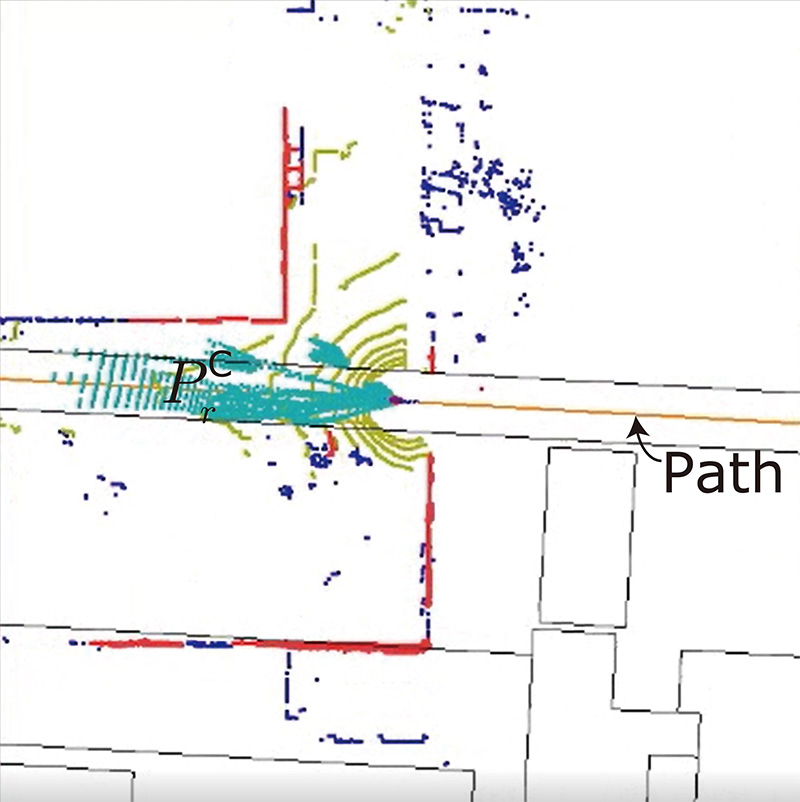
Top view of point clouds in map for localization
- [1] H. Durrant-Whyte and T. Baliey, “Simultaneous Localization and Mapping: part I,” IEEE Robotics and Automation Magazine, Vol.13, No.2, pp. 99-110, 2006.
- [2] T. Baliey and H. Durrant-Whyte, “Simultaneous Localization and Mapping (SLAM): part II,” IEEE Robotics and Automation Magazine, Vol.13, No.3, pp. 108-117, 2006.
- [3] F. Moosmann and C. Stiller, “Velodyne SLAM,” Proc. of IEEE Intelligent Vehicles Symp., pp. 393-398, 2011.
- [4] J. Zhang and S. Singh, “LOAM: Lidar Odometry and Mapping in Real-Time,” Robotics: Science and Systems, Vol.10, 2014.
- [5] T. Shan and B. Englot, “LeGO-LOAM: Lightweight and Ground-Optimized Lidar Odometry and Mapping on Variable Terrain,” Proc. of IEEE/RSJ Int. Conf. on Intelligent Robots and Systems, pp. 4758-4765, 2018.
- [6] D. Fox, W. Burgardy, F. Dellaert, and S. Thrun, “Monte Carlo Localization: Efficient Position Estimation for Mobile Robots,” Proc. of AAAI Conf. on Artificial Intelligence, pp. 343-349, 1999.
- [7] S. Thrun, D. Fox, W. Burgard, and F. Dellaert, “Robust Monte Carlo Localization for Mobile Robots,” Artificial Intelligence, Vol.128, Nos.1-2, pp. 99-141, 2001.
- [8] K. Yoneda, C. Yang, S. Mita, T. Okuya, and K. Muto, “Urban Road Localization by Using Multiple Layer Map Matching and Line Segment Matching,” Proc. of IEEE Intelligent Vehicles Symp., pp. 525-530, 2015.
- [9] P. Biber and W. Strasser, “The Normal Distributions Transform: A New Approach to Laser Scan Matching,” Proc. of IEEE/RSJ Int. Conf. on Intelligent Robots and Systems, pp. 2743-2748, 2003.
- [10] M. Magnusson, A. J. Lilienthal, and T. Duckett, “Scan Registration for Autonomous Mining Vehicles Using 3D-NDT,” J. of Field Robotics, Vol.24, No.10, pp. 803-827, 2007.
- [11] E. Takeuchi and T. Tsubouchi, “A 3-D Scan Matching Using Improved 3-D Normal Distributions Transform for Mobile Robotic Mapping,” Proc. of 2006 IEEE/RSJ Int. Conf. on Intelligent Robots and Systems, pp. 3068-3073, 2006.
- [12] E. Olson, J. Leonard, and S. Teller, “Fast Iterative Optimization of Pose Graphs with Poor Initial Estimates,” Proc. of IEEE Int. Conf. on Robotics and Automation, pp. 2262-2269, 2006.
- [13] K. Konolige, G. Grisetti, R. Kümmerle, W. Burgard, B. Limketkai, and R. Vincent, “Efficient Sparse Pose Adjustment for 2D Mapping,” Proc. of IEEE/RSJ Int. Conf. on Intelligent Robots and Systems, pp. 22-29, 2010.
- [14] R. Kümmerle, G. Grisetti, H. Strasdat, K. Konolige, and W. Burgard, “G2o: A General Framework for Graph Optimization,” Proc. of IEEE Int. Conf. on Robotics and Automation, pp. 3607-3613, 2011.
- [15] M. Hentschel, O. Wulf, and B. Wagner, “A GPS and Laser-Based Localization for Urban and Non-Urban Outdoor Environments,” Proc. of IEEE/RSJ Int. Conf. on Intelligent Robots and Systems, pp. 149-154, 2008.
- [16] M. Hentschel and B. Wagner, “Autonomous Robot Navigation Based on OpenStreetMap Geodata,” Proc. of IEEE Int. Conf. on Intelligent Transportation Systems, pp. 1645-1650, 2010.
- [17] K. Irie and M. Tomono, “Localization and Road Boundary Recognition in Urban Environments Using Digital Street Maps,” Proc. of IEEE Int. Conf. on Robotics and Automation, pp. 4493-4499, 2012.
- [18] Y. Morales, T. Tsubouchi, and S. Yuta, “Vehicle 3D Localization in Mountainous Woodland Environments,” Proc. of IEEE/RSJ Int. Conf. on Intelligent Robots and Systems, pp. 3588-3594, 2009.
- [19] O. Ronneberger, P. Fischer, and T. Brox, “U-Net: Convolutional Networks for Biomedical Image Segmentation,” Proc. of Int. Conf. on Medical Image Computing and Computer-Assisted Intervention, pp. 234-241, 2015.
- [20] E. W. Dijkstra, “A Note on Two Problems in Connexion with Graphs,” Numerische Mathematik, No.1, pp. 269-271, 1959.
This article is published under a Creative Commons Attribution-NoDerivatives 4.0 Internationa License.