Paper:
Study on Risk Reduction in Localization of Cloud-Supported Autonomous Mobile Robots
Mao Nabeta, Kazuteru Tobita
 , Seiya Nakamura, and Kazuhiro Mima
Shizuoka Institute of Science and Technology
2200-2 Toyosawa, Fukuroi, Shizuoka 437-8555, Japan

Recently, outdoor robotics applications have increasingly adopted the “cloud robotics” approach, offloading processing to computationally rich locations via cloud communication due to growing task complexity. However, network conditions in outdoor environments are often volatile, leading to significant performance degradation or unstable behavior in robots owing to poor cloud communication. To address this issue, this study proposes combining minimal self-localization capabilities on the robot side with advanced self-localization processing on the cloud side by integrating and interpolating the two. This paper presents the implementation of 2D self-localization on a robot and 3D self-localization on the cloud, clarifies their characteristics, and proposes a fusion method that combines both self-localization techniques to enhance accuracy and robustness against communication failures. Adaptive Monte Carlo localization (AMCL), a standard algorithm for 2D self-localization, was used on the robot side. Two fusion methods—time-varying weighted average (TVWA) and unscented Kalman filter (UKF)—were implemented. It was shown that the root mean squared error (RMSE) could be reduced to 0.096 m for TVWA and 0.094 m for UKF on closed paths within a 3 m × 4 m rectangle, compared to 0.124 m for AMCL. Furthermore, even with random data loss in the self-localization estimation results from Fast-LIO, the RMSE decreased to 0.102 m for TVWA and 0.097 m for UKF. In this case, the coordinate change before and after the time step due to data loss was reduced from 0.408 to 0.263 m for TVWA and 0.108 m for UKF, indicating that the proposed method reduces the sudden coordinate shifts caused by data loss.
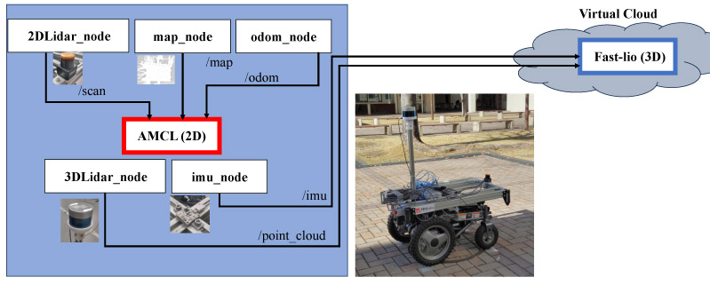
System diagram of cloud-supported AMR
- [1] X. Zhang, J. Lai, D. Xu, H. Li, and M. Fu, “2D Lidar-Based SLAM and Path Planning for Indoor Rescue Using Mobile Robots,” J. Adv. Transp., Vol.2020, No.1, Article No.8867937, 2020. https://doi.org/10.1155/2020/8867937
- [2] I. T. Ruiz, S. de Raucourt, Y. Petillot, and D. M. Lane, “Concurrent mapping and localization using sidescan sonar,” IEEE J. of Oceanic Eng., Vol.29, Issue 2, pp. 442-456, 2004. https://doi.org/10.1109/JOE.2004.829790
- [3] L. von Stumberg, V. Usenko, J. Engel, J. Stückler, and D. Cremers, “From monocular SLAM to autonomous drone exploration,” 2017 European Conf. on Mobile Robots (ECMR), 2017. https://doi.org/10.1109/ECMR.2017.8098709
- [4] S. Yuta, A. Ohya, and N. Shimaji, “Commercial Production of Optical Range-sensor for Intelligent Robot,” J. Robot. Soc. Jpn., Vol.23, No.2, pp. 181-184, 2005. https://doi.org/10.7210/jrsj.23.181
- [5] S. Raikwar, H. Yu, and T. Herlitzius, “2D LIDAR SLAM Localization System for a Mobile Robotic Platform in GPS Denied Environment,” J. Biosyst. Eng., Vol.48, No.2, pp. 123-135, 2023. https://doi.org/10.1007/s42853-023-00176-y
- [6] J. Xiong, Y. Liu, X. Ye, L. Han, H. Qian, and Y. Xu, “A hybrid lidar-based indoor navigation system enhanced by ceiling visual codes for mobile robots,” 2016 IEEE Int. Conf. Robot. and Biomimetics (ROBIO), pp. 1715-1720, 2016. https://doi.org/10.1109/ROBIO.2016.7866575
- [7] W. L. Liu, X. P. Zhao, and B. G. Xu, “Application of Constructing Three-Dimensional Model Using Laser Scanning Technology,” Appl. Mech. Mater., Vols.94-96, pp. 86-89, 2011. https://doi.org/10.4028/www.scientific.net/amm.94-96.86
- [8] J. Y. Ren et al., “LIDAR EKF-SLAM Technology and Its Application in Automated Guided Vehicle Navigation,” DEStech Trans. Comput. Sci. Eng., 2018.
- [9] S. Shen, M. Saito, Y. Uzawa, and T. Ito, “Optimal Clustering of Point Cloud by 2D-LiDAR Using Kalman Filter,” J. Robot. Mechatron., Vol.35, No.2, pp. 424-434, 2023. https://doi.org/10.20965/jrm.2023.p0424
- [10] Y. Kanuki, N. Ohta, and N. Nakazawa, “Development of Autonomous Moving Robot Using Appropriate Technology for Tsukuba Challenge,” J. Robot. Mechatron., Vol.35, No.2, pp. 279-287, 2023. https://doi.org/10.20965/jrm.2023.p0279
- [11] G. Hu, W. P. Tay, and Y. Wen, “Cloud robotics: Architecture, challenges and applications,” IEEE Netw., Vol.26, Issue 3, pp. 21-28, 2012. https://doi.org/10.1109/MNET.2012.6201212
- [12] K. Konno, “Advantages and Disadvantages of Using Cloud Computing: A Comparison of Cloud Computing and On-Premise System,” Ger. Policy Stud., Vol.22, pp. 17-33, 2012.
- [13] M. Nabeta, K. Mima, and K. Tobita, “Research on Risk Assessment in Cloud Control of Autonomous Mobile Robots,” Proc. of JSME annual Conf. Robot. Mechatron. (Robomec), 2023. https://doi.org/10.1299/jsmermd.2023.1A2-I06
- [14] J. Zhang, W. Wen, F. Huang, Y. Wang, X. Chen, and L.-T. Hsu, “GNSS-RTK Adaptively Integrated with LiDAR/IMU Odometry for Continuously Global Positioning in Urban Canyons,” Appl. Sci., Vol.12, Issue 10, Article No.5193, 2022. https://doi.org/10.3390/app12105193
- [15] Z. Niu, X. Zhao, J. Sun, L. Tao, and B. Zhu, “A Continuous Positioning Algorithm Based on RTK and VI-SLAM with Smartphones,” IEEE Access, Vol.8, pp. 185638-185650, 2020. https://doi.org/10.1109/ACCESS.2020.3028119
- [16] D. Lu and E. Schnieder, “Performance evaluation of GNSS for train localization,” IEEE Trans. Intell. Transp. Syst., Vol.16, Issue 2, pp. 1054-1059, 2014. https://doi.org/10.1109/TITS.2014.2349353
- [17] T. Hasegawa, H. Miyoshi, and S. Yuta, “Experimental Study of Seamless Switch Between GNSS- and LiDAR-Based Self-Localization,” J. Robot. Mechatron., Vol.35, No.6, pp. 1514-1523, 2023. https://doi.org/10.20965/jrm.2023.p1514
- [18] Y. Higashi and K. Yamazaki, “Autonomous Flight Using UWB-Based Positioning System with Optical Flow Sensors in a GPS-Denied Environment,” J. Robot. Mechatron., Vol.35, No.2, pp. 328-337, 2023. https://doi.org/10.20965/jrm.2023.p0328
- [19] S. Thrun, D. Fox, W. Burgard, and F. Dellaert, “Robust Monte Carlo localization for mobile robots,” Artif. Intell., Vol.128, Issues 1-2, pp. 99-141, 2001. https://doi.org/10.1016/S0004-3702(01)00069-8
- [20] W. Xu and F. Zhang, “FAST-LIO: A Fast, Robust LiDAR-Inertial Odometry Package by Tightly-Coupled Iterated Kalman Filter,” IEEE Robot. Autom. Lett., Vol.6, Issue 2, pp. 3317-3324, 2021. https://doi.org/10.1109/LRA.2021.3064227
- [21] S. J. Julier and J. K. Uhlmann, “Unscented filtering and nonlinear estimation,” Proc. of IEEE, Vol.92, Issue 3, pp. 401-422, 2004. https://doi.org/10.1109/JPROC.2003.823141
This article is published under a Creative Commons Attribution-NoDerivatives 4.0 Internationa License.