Development Report:
Autonomous Underwater Vehicle “BOSS-A” for Acoustic and Visual Survey of Manganese Crusts
Yuya Nishida*, Kenji Nagahashi**, Takumi Sato**, Adrian Bodenmann**, Blair Thornton**, Akira Asada**, and Tamaki Ura*
*Kyushu Institute of Technology
2-4 Hibikino, Wakamatsu, Kitakyushu, Fukuoka 808-0196, Japan
**The University of Tokyo
4-6-1 Komaba, Meguro, Tokyo 153-8505, Japan

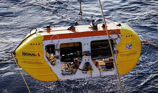
Autonomous underwater vehicle BOSS-A
- [1] B. Thornton et al., “Instruments and Methods for Acoustic and Visual Survey of Manganese Crusts,” J. of Oceanic Engineering, Vol.38, Issue 1, pp. 186-203, 2013.
- [2] Y. Nishida et al., “Autonomous Underwater Vehicle Tuna-Sand for Image Observation of the Seafloor at a Low Altitude,” J. of Robotics and Mechatronics, Vol.24, No.6, pp. 519-521, 2014.
- [3] A. Bodenmann et al., “3D mapping of the seafloor in color using a single camera: Benthic mapping based on video recordings and laser profiling to generate colored 3D reconstructions of the seafloor,” Sea Technology, Vol.51, No.12, pp. 51-53, 2010.
This article is published under a Creative Commons Attribution-NoDerivatives 4.0 Internationa License.