Paper:
Sediment Sorting Processes Affected by Tidal Currents in the Meghna Estuary
Md. Shahinur Rahman*,**, Daisuke Harada*,†, and Shinji Egashira*
*International Centre for Water Hazard and Risk Management (ICHARM), Public Works Research Institute (PWRI)
1-6 Minamihara, Tsukuba, Ibaraki 305-8516, Japan
†Corresponding author
**National Graduate Institute for Policy Studies (GRIPS)
Tokyo, Japan

This study investigates the temporal and spatial characteristics of bed-material sediment sorting in the Meghna Estuary, focusing on both riverine and estuarine regions using a depth-averaged two-dimensional numerical model. A 350 km stretch, including the Lower Meghna River, its mouth, and the surrounding estuarine areas dominated by suspended sediment transport, is simulated to understand the non-uniform sediment transport mechanism and the associated morphological changes that significantly influence the grain size distribution of bed materials. The computational results indicate that sediment sorting in deposition-dominated areas is primarily influenced by the size distribution of deposited materials, which is determined by the deposition rate of each particle size class. In erosion-prone regions, increased erosion rates enhance the downstream transport of finer particles, leading to bed material coarsening. Within the estuarine environment, stronger tidal currents during the ebb phase of spring tides generate increased hydrodynamic energy throughout the tidal cycle, enhancing sediment entrainment from the bedload layer and facilitating the downstream transport of fine particles, thereby contributing to sediment coarsening. In contrast, during the flood phase of neap tides, this process is substantially weakened, leading to reduced sediment mobility and a trend toward sediment fining. Therefore, tidal effects are particularly predominant in erosion-dominated areas of the Meghna Estuary.
1. Introduction
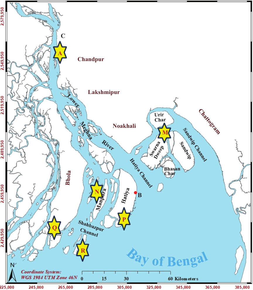
Fig. 1. Meghna Estuary area showing six locations for grain size distribution comparison.
The Ganges, Brahmaputra, and Meghna (GBM) rivers play a crucial role in shaping the Bengal Delta, one of the largest and most dynamic tide-dominated deltas in the world. The GBM river system is the third-largest freshwater outlet in the world after the Amazon and Congo rivers 1. This system transports an exceptional amount of sediment, primarily fine particles, at an annual discharge rate of nearly one billion tons 2. It is recognized as the highest sediment-carrying river system in the world 2. In the Meghna Estuary, sediment is predominantly transported in a suspended form, exhibiting a clear sorting trend characterized by a gradual downstream decrease in grain size. For instance, the average grain size of bed material in the Lower Meghna River is approximately 0.2 mm, while near the estuary’s mouth, where significant topographic changes occur, the average grain size is 0.05 mm or even finer. Effective management of the Meghna Estuary necessitates a comprehensive understanding of sediment-sorting mechanisms driven by riverine and tidal interactions and their role in governing the morphological evolution of the estuarine region. Numerous studies have investigated tidal flow patterns 1,2,3,4,5 and mechanisms of sediment dynamics 1,2,3,6,7 in the Meghna Estuary. Some studies have emphasized quantifying the sediment discharge in the Lower Meghna River 8. Nevertheless, the sediment sorting process within this highly dynamic estuarine system remains largely unexplored. Several studies have provided valuable insights into sediment-sorting mechanisms, particularly those focusing on riverine environments and bedload-dominated transport conditions. For example, Powell investigated the patterns and processes of sediment sorting in gravel-bed rivers 9, and Fu et al. attempted to predict the grain size distribution in an armor layer 10. Biswas et al. indicated that sediment sorting is primarily driven by the differences in sediment mobility across various particle sizes 11. Very few studies have attempted to evaluate the grain size distribution of the channel bed surface layer in a suspended sediment-dominated reach 12. However, limited attention has been paid to evaluating the mechanisms governing the temporal and spatial dynamics of sediment sorting processes in suspended-sediment-dominated estuarine systems influenced by active tidal fluctuations. This may be partly due to the difficulty in analyzing longitudinal sediment sorting using existing suspended sediment erosion schemes that assume equilibrium concentrations at a reference level, as they tend to produce excessively high erosion rates for fine sediment. To address this issue, we employed the erosion rate formula proposed by Harada et al. 13. This formula directly entrains suspended sediment from the bedload layer into the water column based on flow velocities, independent of grain size, enabling the analysis of longitudinal sediment sorting in environments with very fine sediments, such as the Meghna Estuary. This study aims to reveal the temporal and spatial characteristics of the bed-material sediment sorting process in a suspended sediment-dominated estuary area, particularly focusing on the mechanisms of suspended sediment transportation, erosion, and deposition. This study employs a depth-averaged, two-dimensional morphological model for non-uniform sediment sizes to simulate suspended sediment transport and associated bed deformation. Recent field observations were used to set up the model, and comparisons of sediment sorting at multiple locations enhanced confidence in the model’s performance. These findings contribute to a deeper understanding of the sediment sorting processes in suspended-sediment-dominated estuarine environments and are applicable to other tide-influenced systems worldwide.
2. Characteristics of the Study Area
Figure 1 illustrates the Meghna Estuary, including the Lower Meghna River, situated in the southeastern and south-central parts of Bangladesh. The geomorphology of this estuary is characterized by the rapid and dramatic widening of the Lower Meghna River, where shallow waters transition to deeper waters, creating a wide channel that opens into the Bay of Bengal 4. Several prominent deltaic islands, such as Sandwip, Hatiya, Swarna Dweep, Urir Char, Bhasan Char, Manpura, and Bhola, are located near the river mouth 5. Although the sizes, shapes, and locations of these islands have changed over time, they play a crucial role in redistributing flow and sediment throughout the estuary 7. Seasonal flow variation in the Lower Meghna River ranges from 3,000 to 170,000 m\(^3\)/s throughout the hydrological year 5. The flow dynamics within the Meghna Estuary are driven primarily by tidal currents moving from south to north, river outflows through the Hatiya, Shahbazpur, and Tetulia channels, and tide-induced waves originating in the Sandwip Channel 4. Tides along the coast of the Bengal Delta are semi-diurnal, and the highest tidal range, exceeding 8.6 m, has been recorded in the northeast corner of the estuary 7. This estuarine area is predominantly composed of fine-grained sediments, with approximately 70% of sediment particles smaller than 63 μm 6. The representative grain size varies from 0.016 to 0.25 mm in the estuary beds 7. The proportion of suspended sediment was approximately 95% of the total sediment load (by weight) 6. Suspended sediment concentrations (SSC) exhibit considerable variability, increasing by a factor of 2–5 during spring tides compared with neap tides 1. This estuary is highly dynamic and characterized by both erosion and accretion, with a net annual accretion of 18.9 km\(^2\)/yr during the period 1973–2000 7. The wind field in the Bay of Bengal region is dominated by a southwest monsoon with wind speeds ranging from 4 to 5 m/s, prevailing from June to September, and a northeast monsoon with wind speeds of 1.5–3 m/s, active from December to February 4.
3. Methodology
3.1. Governing Equations
This study employed a two-dimensional depth-averaged model for flow calculations to analyze a large domain approximately 350 km long and 550 km wide at downstream end. The governing equations for the two-dimensional (2D) shallow water are as follows:
The parameters \(K_1\), \(K_2\), \(f_f\), and \(f_d\) are clearly defined in the study by Egashira et al. A multilayer concept was applied to a mobile bed with a homogeneous sediment mixture to numerically analyze the sediment transportation process for non-uniform sediments, as proposed by Luu et al. 16. This method can clearly define the bed surface as the boundary between the bed-load and transition layer. In addition, several layers beneath the transition layer were considered deposition layers. In this method, we considered the temporal and spatial variations of the bedload layer instead of assuming a fixed bedload layer thickness. The bedload layer thickness was evaluated using the formula proposed by Egashira et al. 17.
3.2. Model Setup and Calculation Conditions
The calculation domain began 100 km upstream of point C in Fig. 1 and extended approximately 350 km downstream. The initial topography of the Lower Meghna River and the surrounding estuarine area was based on bathymetric data measured in 2019, while the 100 km upstream and 60 km downstream sections were extended using the generated topography to reproduce the non-tidal upstream conditions and deep-sea conditions at the downstream boundary. The grid resolution within the fan-shaped domain varied spatially, with an average cell size of approximately 800 m \(\times\) 700 m. Although the primary focus of this study was to investigate suspended sediment transport and the associated bed-material sediment sorting processes, rather than local-scale variations, the relatively coarse grid resolution facilitated the efficient computation of complex morphodynamic processes within the constraints of computational resources and time. The simulation period was set to one month in July 2020, when the Lower Meghna River experienced the highest annual discharge. This discharge is based on the combined observed monthly average discharge from the Ganges, Brahmaputra, and Upper Meghna Rivers, and was reduced by 13% from the observed value to account for tributary diversion 1. To investigate the riverine environment and the influence of tides on the sediment sorting process, two simulation cases were implemented: a non-tidal case, where tidal variations were omitted at the downstream boundary, and a with-tidal case, which incorporated tidal variations to simulate more realistic conditions. Because real‑time tidal water‑level data near the downstream boundary were unavailable, to analyze the tidal effects in the estuary region, the downstream boundary condition was generated using observed water level data from Hatiya Station (location B in Fig. 1), situated approximately 140 km upstream from the downstream end. The tidal water levels were observed manually during daytime hours, from 6:00 a.m. to 6:00 p.m. Adjustments were made to achieve a satisfactory correlation with the observed data for July, as illustrated in Fig. 2; and the tidal water level was then finalized as the downstream boundary condition, as shown in Fig. 3. In the non-tidal case, a constant water level of 1.86 mMSL was applied as the downstream boundary condition.
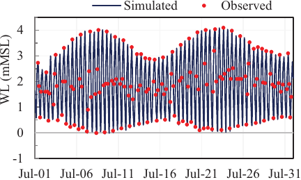
Fig. 2. Comparison of simulated and observed water levels at the Hatiya Station (location B in Fig. 1) in July during the peak monsoon season.
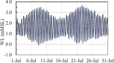
Fig. 3. Downstream boundary condition for tidal water levels in the deep sea boundary in July.
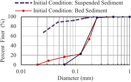
Fig. 4. Observed sediment size distribution (at location A in Fig. 1) and the initial sediment size distribution of the bed material employed in the computation.
Figure 4 shows the initial grain-size distributions of the suspended sediment at the upstream boundary obtained through computation, and of the bed material determined from the observed sediment samples at location A, as shown in Fig. 1. During bed sampling, suspended fine particles were not considered, and a substantial fraction of fine sediment was added to the observed grain-size distribution to define the initial conditions for the numerical simulation. For the calculation, the grain-size distribution was divided into eight size classes, together with the proportion of each class. At the upstream boundary of the morphological model, the suspended sediment concentration was defined under equilibrium condition, and expressed as follows:
The Manning roughness, concentration of the bed load layer, and specific gravity of the sediment particles were set to 0.026, 0.2, and 1.65, respectively. The simulation was conducted using a computational time-step of 0.5 s. In this calculation, the effects of wind fields, saline concentration, and flocculation were not considered. To conduct this numerical simulation, the iRIC-Nays2DH model proposed by Nelson et al. 18 was employed.
4. Results
4.1. Sediment Size Distributions
For the with-tidal case, the computed grain-size distribution was compared with field-observed data at six locations within the study area, as shown in Fig. 5. The locations are shown in Fig. 1. The grid system employed in this study was relatively coarse, making it challenging to select grid points that align precisely with the observed locations. To avoid this discrepancy, five grid points surrounding each observed location were compared to the measured data. Moreover, sediment sorting is highly sensitive to the specific location and timing of sample collection, particularly in morphodynamically active estuarine environments, such as the Meghna Estuary, where manual sampling is involved.
The model results for the sediment grain size distribution at the five surrounding grid points were compared with the observed data, as shown in Fig. 5. Although some discrepancies are present because of inherent limitations, the comparison demonstrates that the computed values closely match the observed sediment sorting process, indicating the model reproduces bed-material sorting.
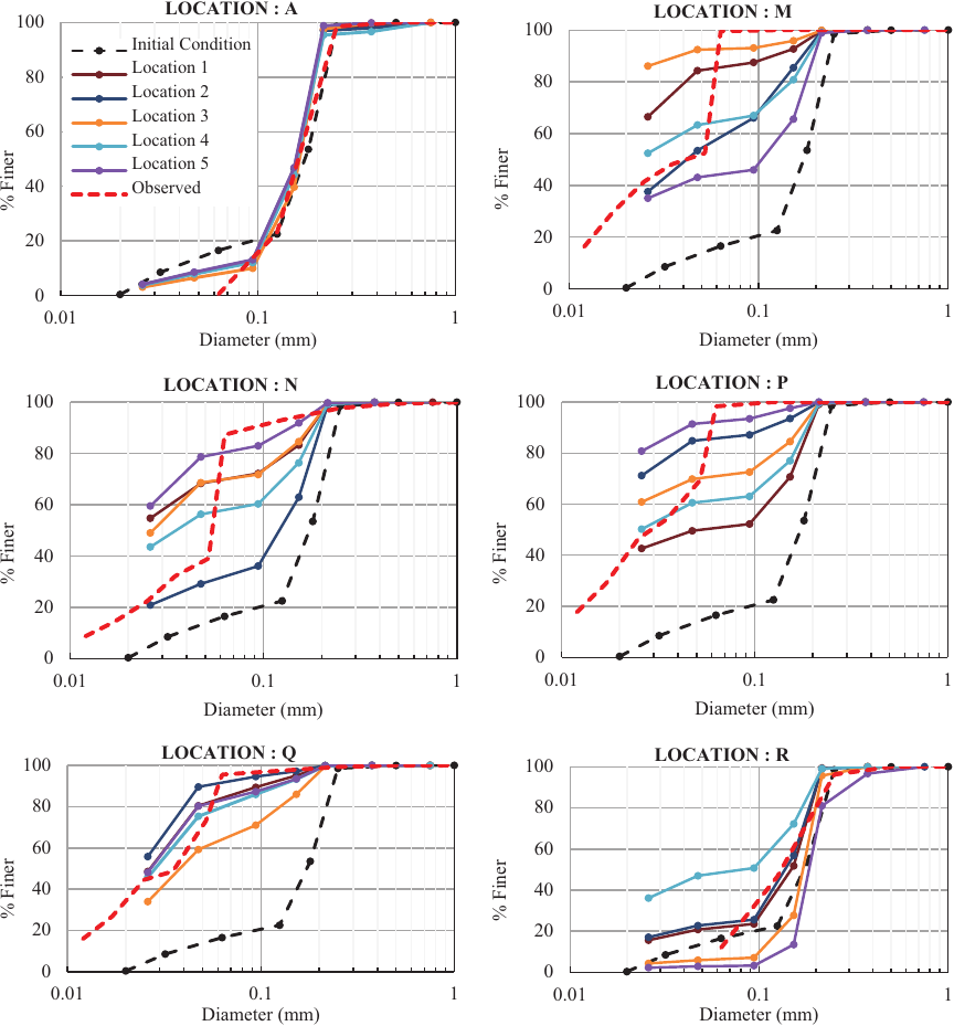
Fig. 5. Comparison of computed and observed sediment sorting at six locations in the Meghna Estuary area, as shown in Fig. 1.
4.2. Morphological Characteristics and Tidal Impacts
Figures 6(a) and (b) compare the results of bed elevation change for the non-tidal and tidal downstream boundary conditions in July. The results indicate that in the non-tidal case, deposition dominates after the midstream reach, whereas far downstream, there is no substantial change in bed elevation. However, in the tidal case, the results show significant bed deformation in the downstream region, indicating that the morphological changes in this area were strongly influenced by tidal currents.
Figures 7(a) and (b) present the computed variation in the suspended sediment concentration during the ebb and flood tide phases under downstream tidal conditions on July 31. The results indicate that the suspended sediment concentration is higher during ebb tide than during flood tide, particularly in the downstream area where tidal fluctuations dominate.
During the ebb tide, the increased flow velocity facilitates sediment transport from upstream to downstream, leading to an increase in sediment concentration. Conversely, during flood tides, the flow velocity decreases, creating a less effective transport condition for sediment compared with the ebb tide, resulting in a lower sediment concentration. However, up to the midstream reach, the suspended sediment concentration follows a similar pattern during both the ebb and flood tides. The variation in the suspended sediment concentration in the downstream area significantly influences the characteristics of the deposited material in deposition-dominated areas and affects the composition of bed material in erosion-prone areas. These findings suggest that from upstream to downstream, coarse particles are deposited more rapidly than fine particles because of their higher fall velocity, and in the far-downstream region, only finer particles dominate in the suspension. Consequently, the deposition rate of fine particles prevails downstream, resulting in sediment fining from upstream to downstream. The results further suggest a significant influence of erosional and depositional processes on controlling sediment sorting characteristics. In addition, active tidal fluctuations play an important role in sediment size distribution, particularly in estuarine environments, where the impact of tidal currents on suspended sediment transport processes strongly influences sediment sorting mechanisms.

Fig. 6. Computed results of the morphological characteristics under (a) non-tidal calculation and (b) tidal downstream conditions over the entire month of July, representing riverine and estuarine environments.
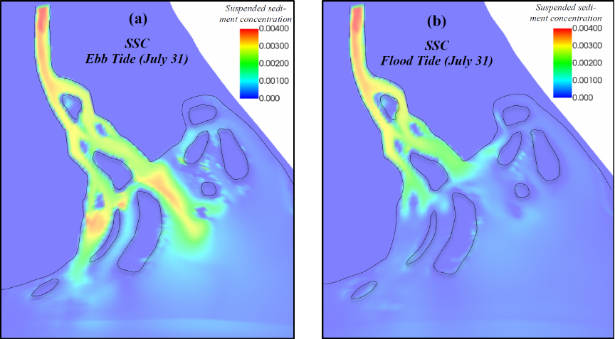
Fig. 7. Computed results of the variation in the suspended sediment concentration during the (a) ebb tide and (b) flood tide phases under tidal conditions on July 31.
4.3. Sediment Sorting Process in the Estuarine Environment During Different Tidal Phases
Figure 8 illustrates the computed results of the temporal characteristics of the mean diameter of the bed material and bed elevation change along with the tidal water level in the erosion-dominated area of the estuarine environment at location E2 (Fig. 6(b)) from July 21 to 22. The results indicate that during the ebb tide, as the water level decreased, the bed elevation also decreased, while the mean diameter of the particles increased, leading to a coarsening process. In contrast, during the flood tide, as the water level increased, the bed elevation increased, and the mean particle diameter decreased, resulting in sediment fining.
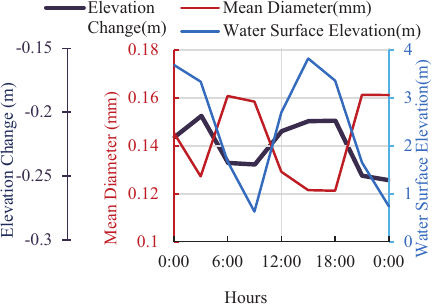
Fig. 8. Computed results of temporal change in the mean particle diameter and the bed deformation, alongside the water level in an erosion dominated location E2 for July 21, as shown in Fig. 6(b).
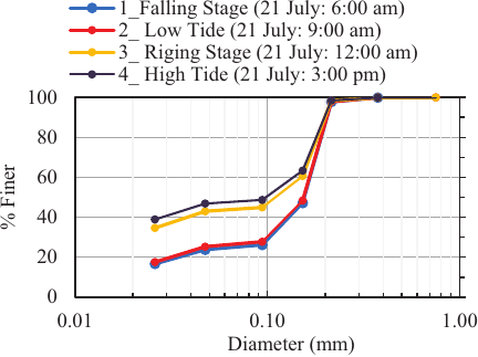
Fig. 9. Computed results of temporal characteristics of sediment sorting in an erosion-dominated location E2 (shown in Fig. 6(b)) on July 21 at different tidal phases.
Figure 9 illustrates the computed results of the sediment sorting process in the erosion-dominated area at location E2 in the estuarine environment during different tidal phases on July 21. The results indicate a considerable influence of tidal fluctuation on sediment sorting, particularly during ebb and flood tides, which alternate at six-hour intervals. During ebb tide, the tidal current increases, generating greater hydraulic energy, which significantly enhances sediment transport and leads to coarsening of the bed material. This phase of the tidal cycle transports a considerable amount of fine and coarse sediment from upstream to location E2, and both fine and coarse particles are entrained from the bed layer to the water, depending on the flow velocity and their relative availability. However, in both cases, coarse particles settled rapidly because of their higher fall velocity, whereas finer particles remained suspended and were transported further downstream.
This process increases the proportion of coarse particles in the bed-load layer, leading to coarsening during the ebb phase of the tidal cycle, with a slight dominance in the falling stage compared with the low tide phase. In contrast, during the flood tide, the flow velocity decreased and was insufficient to transport sediment as effectively as during the ebb tide. This reduction restricts the transport of fine particles, leading to fining, especially during high tides, as shown in Fig. 9.
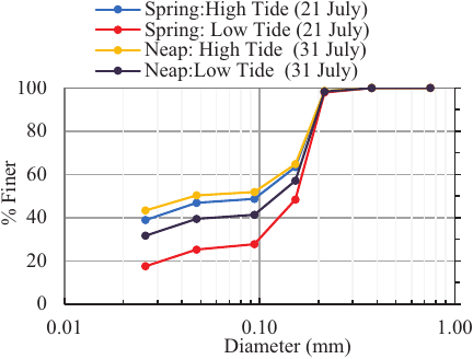
Fig. 10. Computed results of temporal characteristics of sediment sorting in an erosion-dominated location E2 (shown in Fig. 6(b)), during the spring tide on July 21 and neap tide on July 31.
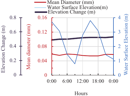
Fig. 11. Computed results of temporal change of the mean particle diameter and the bed deformation, alongside the water level in a deposition-dominated location D2 for July 21, as shown in Fig. 6(b).
Moreover, during the rising stage, the flow velocity remained higher than that during high tide, facilitating the transport of fine particles from location E2, leading to greater coarsening compared to the high-tide period. These sediment transport mechanisms were more pronounced during the spring tide, resulting in a significantly greater sediment coarsening process compared to during the neap tide. Fig. 10 illustrates the sediment sorting at the erosion-dominated location E2 (shown in Fig. 6(b)), during the spring tide on July 21 and neap tide on July 31. The results indicate that during spring tide, particularly during the falling stage of the ebb phase, the coarsening process was more dominant. Conversely, this sediment transportation mechanism gradually weakened during the ebb phase of the neap tide and the flood phase of the spring tide, reaching its lowest intensity during the flood phase of the neap tide. This resulted in a transition from coarsening to fining of the bed material, as shown in Fig. 10.
Figure 11 illustrates the computed results of the temporal characteristics of the mean diameter of the bed material and bed elevation change, along with the tidal water level fluctuation, in the deposition-dominated area of the estuarine environment in the downstream area at location D2 (Fig. 6(b)) from July 21 to 22.
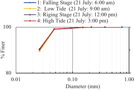
Fig. 12. Computed results of temporal characteristics of sediment sorting in a deposition-dominated location D2 (shown in Fig. 6(b)) on July 21 at different tidal phases.
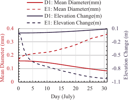
Fig. 13. Computed results of temporal change of the mean particle diameter with the bed deformation, in an eroded location E1 and deposition-dominated location D1 for July, as shown in Fig. 6(a).
The results indicate a slight gradual increase in bed elevation over time, with no significant influence of tidal fluctuations on the mean diameter of the bed particles. Fig. 12 illustrates the computed results of the temporal characteristics of the sediment sorting process in the deposition-dominated area of the estuarine environment at location D2 for different tidal phases on July 21. These results indicate that tidal fluctuations have a limited influence on sediment sorting in this deposition-dominated area throughout the entire tidal cycle.
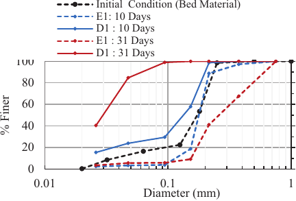
Fig. 14. Computed results of temporal characteristics of sediment sorting in an eroded location E1 and deposition-dominated location D1 for July, as shown in Fig. 6(a).
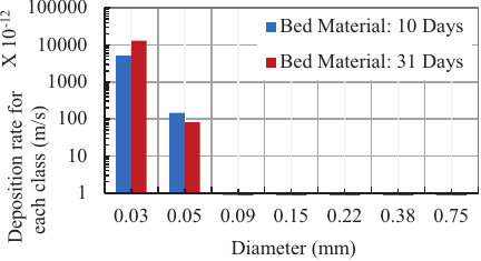
Fig. 15. Computed results of deposition rate for each particle size class in a deposition dominated area at location D1 under the riverine environment (shown in Fig. 6(a)), for 10th and 31st days on July.
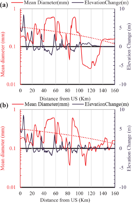
Fig. 16. Computed results of longitudinal mean diameter variation with elevation changes along \(XY\) line, as shown in Fig. 6: (a) non-tidal and (b) with tidal cases.
4.4. Sediment Sorting Process in the Riverine Environment
Figure 13 illustrates the computed results of the temporal changes in mean particle diameter along with bed-elevation changes at the eroded location E1 and deposition-dominated location D1, as shown in Fig. 6(a), in the riverine environment for July.
The results show that at location E1, the mean diameter of the bed material increases as the erosion depth increases (dashed lines), and at location D1, the mean diameter of the bed material decreases as the bed elevation increases (solid lines). Additionally, Fig. 14 shows the temporal characteristics of the sediment sorting process on the 10th and 31st days of July at locations E1 (dashed lines) and D1 (solid lines), where the 10th day represents the early days of the month following model stabilization, and the 31st day reflects the final simulation results. Both results reveal that at the erosion-dominated location E1, the grain size distribution exhibits a coarsening trend, whereas at the deposition-dominated location D1, it follows a fining trend throughout the month. Consequently, in deposition-dominated locations, when the deposition rate of fine particles is higher, sediment fining occurs, whereas when the deposition rate of coarse particles is dominant, a coarsening trend occurs. Fig. 15 illustrates the computed results of the temporal characteristics of the deposition rate of each particle class size in the downstream location at D1 in the riverine environment on the 10th and 31st days of July. The results show that the deposition rate of fine particles increases over time, whereas the deposition rate of coarse particles decreases, leading to an increasing fining process over time at location D1, as shown in Fig. 16. This analysis reveals that the sediment sorting process in a deposition-dominated area follows the same mechanism, emphasizing the influence of temporal variations in the deposition rate of different grain size classes in determining the sediment composition of the bed material. These results also highlight the influence of the erosion depth on the sediment sorting process in erosion-dominated areas, where sediment coarsening becomes more pronounced over time as the erosion depth increases.
4.5. Sediment Size Distribution and Morphological Characteristics
Figures 16(a) and (b) compare the longitudinal variation in the mean sediment diameter with the bed elevation change under non-tidal and tidal downstream boundary conditions along the \(XY\) line, as shown in Fig. 6. Both results suggest a decreasing trend in the mean diameter of the bed material from upstream to downstream. The results indicate a clear correlation between the erosion and deposition patterns and mean sediment diameter. Areas exhibiting erosion tend to have coarser sediments, whereas depositional zones are characterized by finer sediment fractions. In addition, the distinction between the non-tidal case (Fig. 16(a)) and the with-tidal case (Fig. 16(b)) becomes prominent 100 km downstream. In the non-tidal case, deposition dominates between 100 km and 140 km, accompanied by a decrease in the mean sediment diameter. Beyond 140 km, the changes in bed elevation are negligible, and the mean sediment diameter remains largely unchanged.
This is because, under these calculation conditions, the water surface slope downstream of this 100 km point is almost flat. However, under tidal conditions, significant spatial variations in bed elevation and mean sediment diameter are observed beyond the 100 km reach. The results indicate a significant influence of tidal effects on sediment redistribution 100 km downstream. In the present erosion calculation method, Eq. \(\eqref{eq:11}\), both large and very fine bed material are entrained from the bed into the water column in response to the flow velocity. Among these sediments, larger materials settle relatively quickly, whereas finer materials have slower settling velocities, resulting in further downstream transport. Consequently, as shown in Figs. 16(a) and (b), sediment sorting is characterized by a decrease in grain size from upstream to downstream.
This result corresponds to the bed-material survey results shown in Fig. 5. Therefore, the overall results indicate that in riverine environments, sediment sorting in deposition-dominated areas is governed by the grain size of the deposited materials; finer particles lead to sediment fining, whereas coarser deposits cause coarsening. In erosion-prone areas, both fine and coarse particles are entrained; however, coarser particles settle rapidly owing to higher fall velocities, leaving finer sediments to move downstream and creating a coarsening trend from upstream to downstream. In estuarine environments, tidal forces significantly influence sediment dynamics. During the spring-tide ebb phase, strong currents enhance sediment mobility and increase the entrainment of both fine and coarse materials. Coarse particles settle near erosion zones and finer particles are carried downstream, promoting coarsening. This effect diminishes during the neap tide ebb and spring tide flood phases and becomes weakest during the neap tide flood, which can shift the sorting trend toward fining. In contrast, the tidal influence on sediment sorting in the deposition-dominated estuarine zones remains minimal throughout the tidal cycle.
4.6. Influence of Wind Waves
Because of the simplification of the complex interactions within the Meghna Estuary, the influence of wave action on tidal flow and associated sediment transport processes is not considered in the present computation. However, wave effects, particularly during extreme weather conditions, can significantly affect estuarine hydrodynamics in coastal areas through wave–tide interactions. This combined forcing can enhance depth-averaged velocities, increase sediment entrainment, and elevate SSC. Consequently, wave-induced currents may significantly affect the erosion–deposition patterns and associated morphological changes. For simplicity, the general form of the sinusoidal tidal flow field is assumed to be
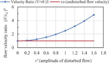
Fig. 17. The relationship between wave-affected flow amplitude and the flow velocity ratio can be used to estimate the erosion rate.
From Eqs. \(\eqref{eq:21}\) and \(\eqref{eq:22}\), the relationship between the erosion rate ratio and amplitude of the disturbed flow can be derived as follows:
Figure 17 shows the relationship between the wave-affected flow amplitude and the erosion rate between the wave-influenced and undisturbed flow conditions, as defined by Eq. \(\eqref{eq:23}\). The results indicate that for wave amplitudes below 0.4, the influence of wave action on erosion rate is minimal. However, when the wave amplitude exceeds 0.4, a pronounced increase in erosion rate is observed, indicating enhanced sediment transport activity. This highlights the critical role of wave–tide interaction in governing sediment dynamics and morphological evolution within the estuary area.
5. Discussions
Several major estuaries and deltas worldwide exhibit hydrodynamic and morphological characteristics broadly comparable to those of the Meghna Estuary, suggesting the potential for similar bed-material sorting mechanisms. Notable examples include the Columbia River Estuary (USA), Nile Delta (Egypt), Amazon River Estuary (Brazil), Mississippi River Delta (USA), Mekong Delta (Vietnam), and Yangtze Delta (China). These systems are commonly characterized by substantial river discharge, strong tidal influences, high suspended-sediment concentrations, and a predominance of fine-grained sediments 19,20. The hydromorphological characteristics of these estuaries and deltas are governed by complex interactions among tidal fluctuations, large riverine discharges, and substantial sediment input. These dynamic conditions significantly influence the sediment transport processes and associated erosion–deposition patterns. Ultimately, these mechanisms control the sorting of bed material and play critical roles in shaping the morphological evolution of globally significant deltas and estuaries. These processes can be evaluated using the mechanisms investigated in this study for the Meghna Estuary.
Previous studies, such as Iwasaki et al. 21, have highlighted the crucial influence of flow fields and sediment transport processes on sediment sorting patterns. Nguyen et al. noted that erosion rates typically increase with the bed-material particle size 22. In suspended-sediment-dominated river reaches, Egashira et al. emphasized that grain-size distribution is mainly governed by the settling characteristics of suspended particles 12. The findings of the present study further reveal that sediment-sorting mechanisms are strongly influenced by flow patterns and sediment transport processes. Specifically, erosion-prone zones tend to exhibit sediment coarsening due to the preferential transport of finer particles, while deposition-dominated areas show sorting patterns governed by the settling velocity and suspended sediment concentration (\(w_0c\)) of individual sediment size classes. These observations are consistent with those of previous studies conducted in riverine environments. Globally, sediment sorting mechanisms have been extensively investigated in riverine systems, particularly under bed-load-dominated conditions. However, these processes have not been clearly addressed in estuarine environments, where suspended sediment transport prevails. In the Meghna Estuary, while previous studies have largely focused on flow characteristics and overall sediment dynamics, limited attention has been paid to evaluating sediment sorting processes. Unlike previous studies, this study focuses on the temporal and spatial variations in sediment sorting processes in a suspended-sediment-dominated estuarine system under the influence of dynamic tidal fluctuations. While most previous investigations have primarily focused on unidirectional flow and bed-load-dominated conditions, the present study emphasizes the integrated effects of suspended sediment supply, erosion, and deposition processes in determining bed-material sorting in a tidally active estuarine environment. Furthermore, Jakobsen et al. 4 suggested that in the absence of extreme hydrological events such as cyclones, wind-induced waves have a limited impact on the overall flow dynamics of the Meghna Estuary. Therefore, because extreme events have a limited influence on long-term sediment transport processes and bed-material sorting mechanisms, the wind effect is not considered in the computation to simplify the numerical simulation of this dynamic estuarine morphology.
6. Conclusion
In this study, a depth-averaged 2D flow model with bed deformation was employed to evaluate the temporal and spatial characteristics of bed-material sorting processes in the suspended sediment-dominated Lower Meghna River and the Meghna Estuary area during the month of peak discharge. The sediment sorting process exhibits notably different characteristics in riverine and estuarine environments, with distinct mechanisms depending on erosion and deposition patterns. The major findings of this study are as follows.
-
Simulation results indicate that, in river systems, sediment sorting in deposition-dominated areas is determined by the grain-size distribution of the deposited material, whereas in erosion-prone areas, increased erosion depth leads to pronounced sediment coarsening as fine particles are transported downstream.
-
Strong tidal influences significantly affect bed‑material sorting in estuarine regions. Particularly during the ebb phases of spring tides, higher flow velocities enhance sediment mobility and facilitate the downstream transport of finer sediments. This leads to an increased proportion of coarse particles and a pronounced coarsening, particularly in erosion-dominated areas.
These findings provide valuable insights into sediment sorting mechanisms for managing fine sediments, including the prediction of future morphological evolution under changing environmental conditions. Notably, this study was conducted with limited time and data availability. Owing to computational constraints, the simulation was performed for one month, with a focus on the peak monsoon period. Under these calculation constraints limitations, the computed results indicate significant variations in bed deformation and mean sediment diameter over short intervals, as shown in Figs. 16(a) and (b). However, long-duration simulations can have a significant impact on the morphological characteristics of the study area. Despite these constraints, the analysis revealed that the bed-material sorting process was influenced by the complex interplay of tidal currents, sediment transport, and morphological changes in suspended-sediment-dominated riverine and estuarine environments.
Acknowledgments
The authors are grateful to Bangladesh Water Development Board and Japan International Cooperation Agency for their support in data collection and financial funding for this study.
- [1] R. Alam, M. S. Islam, M. R. Hasib, and M. Z. H. Khan, “Characteristics of hydrodynamic processes in the Meghna Estuary due to dynamic whirl action,” IOSR J. of Engineering, Vol.4, No.6, pp. 39-50, 2014. https://doi.org/10.9790/3021-04633950
- [2] M. R. Shahinur, D. Harada, and S. Egashira, “Characteristics of morphological change resulting from tidal currents in the Meghna Estuary,” J. of JSCE, Vol.13, Issue 2, Article No.24-16172, 2025. https://doi.org/10.2208/journalofjsce.24-16172
- [3] M. S. Islam and S. Takewaka, “Long-term erosion at the north of Hatiya Island in the Lower Meghna Estuary, Bangladesh,” Coastal Engineering J., Vol.67, Issue 1, pp. 119-135, 2025. https://doi.org/10.1080/21664250.2024.2391141
- [4] F. Jakobsen, M. H. Azam, and M. Mahboob-Ul-Kabir, “Residual flow in the Meghna Estuary on the coastline of Bangladesh,” Estuarine, Coastal and Shelf Science, Vol.55, Issue 4, pp. 587-597, 2002. https://doi.org/10.1006/ecss.2001.0929
- [5] A. M. Rezaie, S. Sumaiya, S. Alam, I. Ahmed, M. H. Ahmed, M. N. Kadir, M. K. B. Siddique, M. A. Jisan, A. Haque, and M. Rahman, “Computation of discharge and flow volume for different flooding scenario in the Lower Meghna Estuary,” 2nd Int. Conf. on Civil Engineering for Sustainable Development, 2014.
- [6] A. Ali, A. E. Mynett, and M. H. Azam, “Sediment dynamics in the Meghna Estuary, Bangladesh: A model study,” J. of Waterway, Port, Coastal, and Ocean Engineering, Vol.133, Issue 4, 2007. https://doi.org/10.1061/(ASCE)0733-950X(2007)133:4(255)
- [7] M. H. Sarker, J. Akter, R. Ferdous, and F. Noor, “Sediment dispersal processes and management in coping with climate change in the Meghna Estuary, Bangladesh,” Proc. of the Workshop on Sediment Problems and Sediment Management in Asian River Basins, Vol.349, pp. 203-218, 2011.
- [8] M. Rahman, M. Dustegir, R. Karim, A. Haque, R. J. Nicholls, S. E. Darby, H. Nakagawa, M. Hossain, F. E. Dunn, and M. Akter, “Recent sediment flux to the Ganges-Brahmaputra-Meghna delta system,” Science of the Total Environment, Vol.643, pp. 1054-1064, 2018. https://doi.org/10.1016/j.scitotenv.2018.06.147
- [9] D. M. Powell, “Patterns and processes of sediment sorting in gravel-bed rivers,” Progress in Physical Geography: Earth and Environment, Vol.22, Issue 1, 1998. https://doi.org/10.1177/030913339802200101
- [10] H. Fu, Y. Shan, and C. Liu, “A model for predicting the grain size distribution of an armor layer under clear water scouring,” J. of Hydrology, Vol.623, Article No.129842, 2023. https://doi.org/10.1016/j.jhydrol.2023.129842
- [11] R. K. Biswas, S. Egashira, D. Harada, and Y. Nakamura, “Lateral and longitudinal sediment sorting in Seri River, Japan,” J. of Japan Society of Civil Engineers, Ser. B1 (Hydraulic Engineering), Vol.75, No.2, pp. I_895-I_900, 2019.
- [12] S. Egashira, M. Qin, N. Nagumo, and D. Harada, “Sediment sorting in suspended sediment dominated rivers,” Japanese J. of JSCE, Vol.80, No.16, 2023 (in Japanese). https://doi.org/10.2208/jscejj.23-16055
- [13] D. Harada, S. Egashira, T. S. Ahmed, and H. Ito, “Entrainment of bed sediment composed of very fine material,” Earth Surface Processes and Landforms, Vol.47, Issue 13, pp. 3051-3061, 2022. https://doi.org/10.1002/esp.5442
- [14] S. Egashira and K. Ashida, “Studies on the structures of density stratified flows,” Bulletin of the Disaster Prevention Research Institute, Vol.29, No.4, pp. 165-198, 1980. http://hdl.handle.net/2433/124887
- [15] S. Egashira, K. Miyamoto, and T. Ito, “Bed-load rate in view of two phase flow dynamics,” Proc. of Hydraulic Engineering, Vol.41, pp. 789-794, 1997.
- [16] X. L. Luu, S. Egashira, and H. Takebayashi, “A new treatment of the exchange layer thickness to evaluate sediment sorting and armoring,” J. of Applied Mechanics, Vol.9, pp. 1025-1030, 2006. https://doi.org/10.2208/journalam.9.1025
- [17] S. Egashira, K. Ashida, J.-I. Takahama, and S. Tanonaka, “Derivation of bed-load formula from a view point of continuum body,” Annual J. of Hydraulic Engineering, Vol.35, pp. 441-446, 1991 (in Japanese).
- [18] J. M. Nelson, Y. Shimizu, T. Abe, K. Asahi, M. Gamou, T. Inoue, T. Iwasaki, T. Kakinuma, S. Kawamura, I. Kimura, T. Kyuka, R. R. McDonald, M. Nabi, M. Nakatsugawa, F. R. Simões, H. Takebayashi, and Y. Watanabe, “The International River Interface Cooperative: Public domain flow and morphodynamics software for education and applications,” Advances in Water Resources, Vol.93, pp. 62-74, 2016. https://doi.org/10.1016/j.advwatres.2015.09.017
- [19] L. D. Wright and C. A. Nittrouer, “Dispersal of river sediments in coastal seas: Six contrasting cases,” Estuaries, Vol.18, No.3, pp. 494-508, 1995.
- [20] L. Giosan, J. Syvitski, S. Constantinescu, and J. Day, “Climate change: Protect the world’s deltas,” Nature, Vol.516, Issue 729, pp. 31-33, 2014. https://doi.org/10.1038/516031a
- [21] T. Iwasaki, Y. Shimizu, and I. Kimura, “Computations of bed deformation and sediment sorting in meander channel using depth-averaged morphodyamic model,” Int. J. of River Basin Management, Vol.9, Issues 3-4, pp. 237-245, 2011. https://doi.org/10.1080/15715124.2011.597756
- [22] V. B. Nguyen, Q. B. Nguyen, Y. W. Zhang, C. Y. H. Lim, and B. C. Khoo, “Effect of particle size on erosion characteristics,” Wear, Vols.348-349, pp. 126-137, 2016. https://doi.org/10.1016/j.wear.2015.12.003
This article is published under a Creative Commons Attribution-NoDerivatives 4.0 Internationa License.