Paper:
Operationalizing Updated Tsunami Hazard Assumptions in School Evacuation Planning: Insights from Teacher Training and Implementation Challenges in Japan
Aiko Sakurai*1,*2,†
 , Makoto Kumagai*3, Yoshiyuki Murayama*2, Mizan B. F. Bisri*1,*4
, and Takeshi Sato*2
, Makoto Kumagai*3, Yoshiyuki Murayama*2, Mizan B. F. Bisri*1,*4
, and Takeshi Sato*2
*1Graduate School of International Cooperation Studies (GSICS), Kobe University
2-1 Rokkodai-cho, Nada-ku, Kobe, Hyogo 657-8501, Japan
*2International Research Institution of Disaster Science (IRIDeS), Tohoku University
Sendai, Japan
*3Yamagata University
Yamagata, Japan
*4Asian Disaster Reduction Center (ADRC)
Kobe, Japan
†Corresponding author

This study analyzes the tsunami evacuation plan revision process through in-service teacher training in Ishinomaki City, Miyagi Prefecture, to empirically validate the effectiveness of the Risk-Informed Decision-Making (RIDM) Approach. Revising the maximum-class (Level 2) tsunami hazard assumptions in 2022 necessitated the review of evacuation plans for all municipal schools. Analyzing the 2022 training (baseline) revealed that despite exposure to new hazard information teachers demonstrated an institutional and psychological adherence to “familiar sites” (school facilities). To address this challenge, the RIDM Approach was developed for systematically enhancing teachers’ decision-making capacity and was subsequently validated during the 2023 training. This approach combines simulations using multi-hazard scenarios with instruction on a scientific, evidence-based decision protocol. The validation results revealed that this structured intervention led to a significant increase in the proportion of teachers recommending safe horizontal evacuation. This study demonstrates that the RIDM Approach provides an empirically effective solution to the structural challenge where teachers bear responsibility for disaster response but face institutional and psychological barriers to deviating from established plans. The findings establish the RIDM Approach as a replicable, systematic educational mechanism—not reliant on specialist knowledge—that offers a clear policy blueprint for school-level disaster risk reduction facing similar structural misalignments globally.
1. Introduction
Tsunami evacuation planning at schools is a critical component of disaster risk reduction (DRR), particularly in countries such as Japan, where densely populated coastal communities face recurrent seismic threats. School-based tsunami evacuation drills and disaster education have proven effective in promoting risk awareness and preparedness among students and teachers [1–3]. Although these efforts are commendable, a significant challenge persists, the practical application of scientific tsunami risk information such as hazard maps or inundation simulations to real-time decision-making by teachers during actual or simulated emergencies remains largely unexplored and under-examined.
One compelling example of effective disaster education is Kamaishi City where schoolchildren were successfully evacuated during the 2011 Great East Japan Earthquake (GEJE) and Tsunami. Katada and Kanai 4 analyzed this case, emphasizing that consistent disaster education and student-centered drills significantly contribute to children’s self-directed evacuation behaviors. This underscores the importance of fostering proactive capacity among children through school-based programs.
Simulation-based decision support 5,6 and agent-based evacuation models 7,8 have significantly enhanced the visual understanding of complex tsunami behavior, providing dynamic insights that static maps cannot. These tools are not only valuable for city planning, but have also proven effective for risk communication and disaster education. For instance, Goto et al. 9 applied agent-based tsunami evacuation modeling in Banda Aceh, Indonesia to visualize pedestrian flow and assess the feasibility of different escape scenarios. Such tools can effectively serve educational purposes by enhancing teachers’ and students’ spatial and temporal understanding of tsunami risk. However, despite the proven utility and educational potential of these advanced simulation tools, their systematic integration into teacher training frameworks remains limited.
Therefore, teacher training is a crucial factor in effective school-based evacuation planning, as it directly influences the preparedness of educational institutions to handle emergencies efficiently. A critical review of emergency evacuation planning highlights the importance of training and preparing staff to ensure successful implementation of evacuation strategies 10. This review discusses the persistent gaps in current approaches, including limitations in the design and execution of simulation exercises, which are often owing to inadequate training components.
Beyond design flaws, the role of simulation models as tools for developing and testing evacuation plans provides significant benefits for emergency preparedness. Specifically, well-designed training aids in enhancing management, coordination, and communication functions during an evacuation 11. This underscores not only the necessity for robust teacher training in evacuation planning, but also highlights the critical need for effective pedagogical continuity and adequate institutional support to navigate high-stakes scenarios such as evacuations.
The issues of effective teacher preparedness and robust school safety mechanisms have been internationally recognized. The Sendai Framework for Disaster Risk Reduction (2015–2030) advocates a shift from reactive to risk-informed decision-making, explicitly highlighting the role of education and training in developing disaster-resilient communities 12. In parallel, the Comprehensive School Safety Framework (CSSF), endorsed by UNESCO, UNICEF, and other global agencies, positions schools as central actors in disaster preparedness, emphasizing risk reduction through curriculum, facilities, and management 13.
However, while emphasizing the role of education, both frameworks offer limited operational guidance on how teachers, as decision makers on the frontline, interpret and apply risk information during real-time evacuation scenarios. In Indonesia, Rafliana 14 documents how disaster education evolved over the six years following the 2004 Indian Ocean tsunami, highlighting both top-down government efforts and grassroots school-based initiatives. It underscores the importance of teacher capacity building and long-term institutional commitment in sustaining DRR education. Similarly, studies exploring the minimum essentials for sustainable school disaster preparedness in regions such as Banda Aceh, Indonesia emphasize these crucial factors 15.
In Japan, the Tsunami Disaster Prevention Regional Development Law (2011) provides a legal framework for tsunami risk assessment, inundation prediction, and hazard map creation. This process is largely top-down: technical modeling by the national government, followed by inundation zone designation by prefectures, and finally hazard map publication and evacuation planning by municipalities. Crucially, the connection between this legally mandated planning process and schoolteachers’ professional development remains unexplored.
At the international level, the UNESCO/IOC Tsunami Ready program offers a performance-based community certification model for tsunami preparedness based on 12 indicators across assessment, preparedness, and response 16. Similarly, Scheer et al. 17 presented a structured three-step planning framework—risk analysis, plan production, and maintenance. However, despite the application of these frameworks at the regional or municipal levels, few studies have specifically examined their intersection with school-based evacuation training, particularly from the standpoint of teachers’ decision-making capacity.
This study aims to bridge gaps between geoscientific tsunami risk information, national legal frameworks, international DRR standards, and the lived realities of teacher training in tsunami-prone schools. We specifically focus on how in-service teacher training programs can function as a connecting layer between scientific information and school-level decision-making. Thus, we pose the following research questions:
-
1)
How do teacher training programs facilitate the integration of scientific tsunami risk information (e.g., hazard maps and inundation predictions) into evacuation decision-making in schools?
-
2)
What forms of institutional support are necessary for teachers to take proactive roles in risk-informed decision-making for plan revision?
Our central academic contribution is the empirical demonstration that the structured Risk-Informed Decision-Making (RIDM) Approach can successfully overcome the institutional and psychological barriers that prevent teachers from adopting safer, risk-informed evacuation plans. This systematic approach provides a tangible mechanism for local educational actors to implement risk-informed decision-making and all-of-society engagement mandated by the Sendai Framework for Disaster Risk Reduction (SFDRR Priority 2). This study offers a globally relevant policy blueprint for local governance reform in DRR, by focusing on the structural misalignment between accountability and authority.
2. Bridging Policy and Practice: The Ishinomaki Case for Teacher Training
2.1. Okawa Elementary School Tsunami incident by the 2011 Great East Japan Earthquake and Tsunami
Ishinomaki City, in Miyagi Prefecture, was among the municipalities most severely affected by the tsunami off the Pacific coast of Tohoku in 2011. The city recorded the highest number of disaster-related deaths in the Tohoku region, particularly in the low-lying coastal areas. One of the most tragic incidents was the loss of 74 students and 10 teachers at Okawa Elementary School (OES), which became a national and international symbol of the failure of school-based disaster preparedness 18.
A landmark civil ruling by the Sendai High Court found both municipal and prefectural governments to be negligent, establishing that the failure to anticipate tsunami risk and take precautionary measures breached their duties under the School Health and Safety Act. Notably, at the time of the disaster, the school was located outside the official tsunami hazard zone and no specific tsunami evacuation plans existed. The court emphasized that precautionary planning, even amid scientific uncertainty, was legally and ethically required.
Sakurai points out that this case catalyzed a structural shift in Japan’s approach to school risk governance 19. The incident and the resulting high court decision triggered a re-examination of school disaster preparedness, emphasizing that each school must not only rely on hazard maps but also assess localized risks and develop effective contingency plans accordingly. Furthermore, the 24-point recommendation issued by the OES Incident Investigation Committee underscored the importance of pre-service and in-service teacher training, localized disaster manuals, stakeholder collaboration, and risk communication mechanisms.
In the years that followed, the Ministry of Education, Culture, Sports, Science and Technology (MEXT) institutionalized these lessons by revising its national School Safety Promotion Plans and issuing new guidelines urging all schools to reflect local disaster contexts in their safety policies 20. This marks a paradigm shift from a passive, compliance-based safety culture to a proactive, risk-informed, and teacher-empowered DRR framework in Japanese schools 19.
This legal and societal precedent has significantly shaped both educational policy and risk management systems in post-2011 Japan, not only reinforcing scenario-based evacuation planning, but also underlining the need to position school teachers as key actors in localized, real-time decision-making.
Although this policy shift represents a major step forward, a gap remains between the new DRR framework and its practical implementation in schools. Questions persist about how schools can operationalize these guidelines and effectively translate policies into everyday preparedness measures.
2.2. Updated Hazard Assumptions, Institutional Gaps, and the Rationale for the Study
In 2022, Miyagi Prefecture released a new tsunami inundation simulation based on a worst-case multi-hazard scenario that includes high tides, earthquake-induced land subsidence, and destruction of seawalls 21. This new inundation assumption is based on maximum-class Level 2 tsunami scenarios. In Japan’s dual-tier tsunami precaution system, Level 1 (L1) tsunamis are those expected with a relatively high frequency, used for issuing immediate evacuation orders, and are generally addressed by evacuating to designated safe places, often including verified vertical evacuation facilities. Conversely, Level 2 (L2) scenarios represent the maximum possible class of tsunamis expected to occur once every several hundred to thousands of years. The critical distinction is that L2 tsunamis are anticipated to exceed and overwhelm the existing protective infrastructure, making comprehensive, immediate horizontal evacuation (off-site evacuation) to high natural ground the only reliable strategy for saving lives.
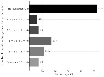
Fig. 1. Distribution of public schools in Ishinomaki by expected tsunami inundation depth (\(N =54\)).
This revised risk scenario drastically expanded the assumed inundation zones, placing 26 of public schools (48%) in Ishinomaki within areas projected to experience 0.3 to 10 m of inundation (Fig. 1). Furthermore, six of the 26 schools were not inundated by the 2011 tsunami but are now expected to be newly inundated.
In 2019, MEXT issued a notice urging schools to develop evacuation plans and conduct evacuation drills related to tsunami response in accordance with the Act on Tsunami Disaster Prevention Regional Development 22.
Under the legal framework, and in response to these updated assumptions, schools located in the revised inundation zones were required to re-examine their evacuation plans and safety measures. However, practical guidance and updated training frameworks to adequately support teachers in implementing risk-informed decision-making remained conspicuously limited. To address this crucial gap, academic researchers collaborated with the Ishinomaki City Board of Education to examine a specific in-service teacher-training program. This collaborative effort forms the case for the present study, which aims to examine how this teacher-training program functions as a connecting layer between advanced scientific information and school-level evacuation decision-making, thereby addressing the research questions posed in the Introduction.
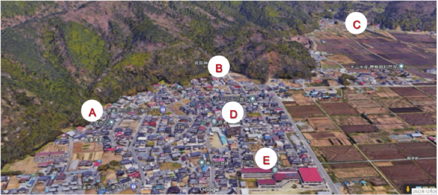
The map was created based on Google Maps.
Fig. 2. Candidate tsunami emergency evacuation sites near the school.
3. Methodology
3.1. The Proposed RIDM Approach and Program Design
In response to the research questions outlined in the introduction, this study employs an action research methodology that is particularly suitable for contexts in which solutions must be developed collaboratively with practitioners and iteratively refined through feedback. The intervention is framed as the development and validation of the RIDM Approach for school evacuation planning. The RIDM Approach is a structured capacity-building framework designed to bridge the gap between scientific hazard information (top-down) and teachers’ on-site capacity and knowledge (bottom-up), thereby strengthening their critical decision-making abilities for evacuation planning. This approach comprises three sequential core phases.
-
(a)
Information Input and Baseline Assessment: Provide updated scientific risk information and measure participants’ initial decision-making baseline.
-
(b)
Multi-Criteria Evaluation (MCE) and Decision Exercise: Structured tools to critically evaluate candidate sites based on multiple criteria and local knowledge.
-
(c)
Reflection and Institutional Feedback: Encourage self-reflection and promote the application of findings to formal school evacuation plans.
The research team, comprising academic researchers specializing in disaster education, earthquake engineering, tsunami engineering, and geography, partnered with the Ishinomaki City Board of Education. This partnership aimed to design and implement an in-service teacher training program to enable teachers to revise and strengthen their school tsunami evacuation plans in response to newly updated hazard assumptions. The training sessions were held at a branch office of the city government and attended by DRR teachers from 54 municipal schools. Miyagi Prefecture has two school-level safety positions: Disaster Preparedness Coordinators and Safety Chief Teachers. The DRR teachers who participated in the training included both Disaster Preparedness Coordinators assigned to each school and ten Safety Chief Teachers across the city.
The RIDM Approach was implemented in two distinct phases (2022 and 2023) to facilitate development and validation, building upon a previously developed training module titled “Understanding Disaster Risk Based on the Topography of School Districts” 23.
3.1.1. Implementation Phase 1: Initial Validation (2022)
During the 2022 in-service training, which served as the initial validation phase of the RIDM Approach (Phase 1), primarily aimed at understanding the baseline capability of DRR teachers and exploring initial decision-making tendencies regarding tsunami evacuation. Participating DRR teachers were guided to examine potential tsunami emergency evacuation sites using a structured worksheet developed by the authors.
The 2022 training centered on examining potential tsunami evacuation sites using X Elementary School as a case study. Specific details regarding the school’s geographic context, the urgent need for reevaluation owing to the revised 2022 hazard assumptions, and the rationale for its selection as a baseline analysis are detailed in Section 3.2.
This phase primarily served as the baseline assessment (Phase 1 of the RIDM Approach). Before conducting the exercises, participants attended a lecture that presented updated tsunami risk assumptions, including expected inundation depths and estimated arrival times of the first wave, highlighting that the school district faced simultaneous risks from landslides and tsunamis. Participants then prioritized candidate emergency evacuation sites near the school (Fig. 2), explaining their reasoning individually and through group discussions.
The data collected during this phase were analyzed to identify critical factors influencing teachers’ decisions.
The analysis indicated that despite being informed of the available evacuation time (approximately 50 min to the first wave), many participants exhibited a strong psychological tendency to favor vertical evacuation within school premises or prioritize sites close to the school. This suggests that the time buffer was not used effectively to plan comprehensive horizontal evacuation strategies. This finding reveals a critical gap between scientific information (time buffer) and actionable decision-making, which appears to be driven by institutional and psychological preferences for school premises, serving as the primary rationale for refining the RIDM Approach’s input phase in 2023.
3.1.2. Implementation Phase 2: Refinement and Targeted Intervention (2023)
To address the institutional and psychological preferences identified in the 2022 analysis (Section 4.1), which compromised the effective use of the available 50-minute time buffer for safe horizontal evacuation, the Information Input Phase (Phase 1) of the RIDM Approach was fundamentally refined for 2023 training.
The 90-minute training session systematically implemented the refined RIDM Approach, as detailed in Table 1, and was strategically designed to challenge the prevailing tendency to favor staying within school premises. Specifically, the intervention used a worst-case, multi-hazard scenario in which the L2 Tsunami Warning coincided with a Heavy Rain Warning. This scenario was selected to remove the psychological comfort associated with vertical evacuation and compel teachers to recognize the necessity of using a 50-minute time buffer for comprehensive horizontal evacuation. The scenario was further structured to reveal the latent risks of local candidate sites. While the school building itself was not located in a landslide-prone area, many of the nearby, readily selectable evacuation sites identified in 2022 were vulnerable to landslide risk owing to heavy rain.
Crucially, the training program prominently featured an institutional feedback loop identified through action research methodology and used two evidence-based peer-learning components. First, considering that over half of the DRR teachers changed between 2022 and 2023, the 2023 session was initiated by explicitly sharing the aggregated decision-making results from the 2022 training (Section 4.1). This ensured that all participants, including new attendees, understood the identified gap, which necessitated refinement of the approach and subsequent targeted intervention.
Second, the case school (X Elementary School), subject of the 2022 baseline, used the acquired insights to revise its tsunami evacuation plan and conduct subsequent drills. Successful locally adapted revisions served as a practical implementation benchmark, demonstrating the output of the institutional feedback loop. The 2023 program (Component 3, Table 1) continued with a presentation by the school’s DRR teacher sharing concrete, peer-to-peer insights into the practical challenges and success of revising the plan.
Furthermore, the session included a crucial case study presentation from an elementary school that successfully executed horizontal evacuation during the GEJE. This example specifically demonstrates that children’s lives were saved owing to prompt horizontal evacuation, although the school building itself later suffered severe damage from a tsunami-induced fire (a secondary hazard). This powerful real-world evidence directly challenged the institutional and psychological preference toward staying within school premises by highlighting the definitive necessity of safe, immediate evacuation and promoting multi-risk thinking.
Table 1. Components of the training program.

3.2. Representative Case Used in Training
To contextualize evacuation planning and site evaluation exercises, the training program employed a representative case from a local school, X Elementary School. Located approximately 1 km from the coastline on an alluvial plain with an elevation of approximately 2.1 m, the school experienced a tsunami inundation of 0.5 to 2.0 m during the 2011 GEJE. Under the 2022 revised tsunami inundation assumptions published by Miyagi Prefecture, a maximum tsunami height of 3.0 to 5.0 m is expected near the school, with the first wave predicted to arrive in 49 min at the nearest point in the sea to the school, with the highest tsunami reaching the coastal district in 56 min. The inundation zones and topographical characteristics of the school districts are presented in Fig. 3.
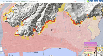
(“\(+\)” shows the school location on the maps)
The maps were created and modified based on the Web-GIS of the Geospatial Information Authority of Japan.
Fig. 3. Tsunami inundation hazard map in X Elementary School district.
The school was designated as an emergency tsunami evacuation site and shelter by the municipal government. However, deeper inundation projections have raised concerns that the second floor, initially planned as the primary refuge, will no longer provide adequate safety. This case was selected because it presented realistic constraints on evacuation timing, space limitations, and the need to prioritize multiple imperfect options, thus making it an ideal scenario for discussion and decision-making exercises among DRR teachers.
As a part of the training exercise, the research team presented teachers at School X with five candidate evacuation sites based on updated inundation scenarios, elevation data, and accessibility (Table 2).
3.3. Data Collection and Analysis
The 2022 training program served as a pilot implementation to test the usability of the training components and their relevance to the newly revised tsunami hazard assumptions. Feedback and outcomes from the 2022 session identified critical institutional and psychological preferences for school premises (as detailed in Section 4.1), which informed refinements made to the 2023 program, emphasizing school-level evacuation decision-making and prioritization of evacuation sites under specific hazard scenarios.
Table 2. Candidate evacuation sites.

This study uses structured worksheets collected from both the 2022 (baseline) and 2023 (validation) training sessions. The data from 2022 establish the pre-intervention institutional baseline for decision-making (Section 4.1). However, the primary comparative analysis centers on the 2023 worksheets, which were designed for the pre-post measurement of the effect of the approach. During the 2023 session, each teacher completed two sequential exercises: the first required them to individually evaluate and prioritize multiple tsunami evacuation sites based on their initial understanding of the hazard information (pre-test), and the second prompted them to reconsider their choices after receiving a targeted lecture on interpreting and applying scientific tsunami risk information and decision-making protocols (post-test). This sequential approach allows the observation of shifts in decision-making after specific informational interventions.
The worksheets provided quantitative data in the form of ranked site preferences and Likert-scale ratings as well as qualitative data via optional comment fields where participants explained their reasoning. Descriptive statistics were used to calculate the average rankings and identify common decision patterns. Additionally, qualitative data (open-ended responses) were reviewed to acquire deeper insights into teachers’ underlying decision-making rationales and identify perceived needs for further institutional support. These insights proved valuable in framing the discussion of institutional and psychological barriers.
To ensure the participants’ anonymity, all worksheets were designed to be completed without requiring personal identification or sensitive information. All responses were obtained during a City Board of Education-authorized training session conducted in a professional capacity, and no personal or sensitive information was collected.
4. Results
4.1. Results of Initial Validation in 2022
During the 2022 training, which served as the initial validation phase of the RIDM (Phase 1), primarily aimed at understanding the baseline capability of DRR teachers and exploring initial decision-making tendencies regarding tsunami evacuation, participating DRR teachers were guided to examine potential tsunami emergency evacuation sites using a structured worksheet developed by the authors. The worksheet identified five key categories of considerations: (1) topography and disaster risks at each location (e.g., elevation, flooding, and landslides); (2) route conditions and risks; (3) facilities and physical characteristics of each site (e.g., capacity and structure); (4) prior arrangements (e.g., agreements with owners, inspections, and stockpiling); and (5) contingency plans. This comprehensive approach aimed to help teachers systematically compare multiple sites and reflect on both geographical and institutional factors affecting emergency planning. The initial exercise results are summarized in Table 3.
Table 3. Prioritization of tsunami evacuation sites.

Although the training targeted all 54 municipal schools, responses were obtained from only 50 participants. Among them, 48 (96%) completed the prioritization task by assigning rank 1 to one of the five evacuation options, whereas two participants did not assign any ranking. Two-thirds (\(n =32\)) selected the school’s third floor as their top choice, reflected in the weighted average score of 1.5 (with lower scores indicating higher priority). This statistical result points to a critical dilemma: while the third floor offers elevation and immediate access, it carries a significant risk of being overtopped by an unexpectedly large tsunami, which is a vulnerability underscored by the updated 2022 hazard models.
The qualitative analysis of open-ended responses confirmed the underlying reasons for this preference, revealing a consensus around factors such as familiarity (“a place we are used to”), perceived safety (“feel secure”), administrative convenience (“easy hand-over of students,” “designated shelter”), and resource availability (“on-site stockpiles”).
These initial results, supported by both quantitative selection data and a qualitative rationale, suggest that even when presented with a structured evaluation framework, teachers tend to gravitate toward the school as a perceived safe space, reflecting a strong institutional and psychological preference for premises within their immediate control. This finding points to a foundational, institutional, and psychological gap in integrating complex scientific risk information, as explored in RQ1, and highlights the necessity for pedagogical approaches that guide teachers beyond familiar solutions. Moreover, it underscores the urgent need for tailored capacity building and sustained institutional and pedagogical support (as investigated in RQ2) to enable schools to plan flexible, context-sensitive, and robust evacuation strategies that realistically address the strengths and limitations of each site considering evolving hazard data.
Table 4. Evaluation criteria for evacuation sites.

4.2. Evaluation Criteria and School-Level Decision-Making
Building on the outcomes of the 2022 training, the authors developed and refined a set of 20 evaluation criteria, referred to here as the Evacuation Criteria for Evacuation Sites (Table 4). These criteria provide a systematic framework for teachers to assess potential evacuation sites by considering elevation, distance from the coast, route safety, capacity, coordination feasibility with external stakeholders, legal and administrative issues, and vulnerability to secondary hazards such as landslides or tsunami-induced fires.
In March 2023, X Elementary School conducted an all-staff training using this evaluation framework. Teachers scored each candidate site using a twenty-point criteria sheet, followed by a lecture by the chief DRR teacher on local landforms and disaster risks. Owing to internal procedural constraints and respect for participant privacy, the aggregated scoring data from all teachers were not disclosed or made available to the research teams. However, the school presented its final decision and rationale during the 2023 training, selecting K Mountain as the primary evacuation site for major tsunami warnings, designating a nearby private apartment building as an alternative, and deciding to use the school’s third floor for vertical evacuation in the case of lower-level tsunami alerts.
Importantly, a drill conducted in June 2023 revealed that the school’s third floor lacked sufficient capacity to accommodate more than 280 pupils, considering the school’s agreement to shelter children from a nearby nursery during the tsunami warnings. Additionally, because the school building is officially designated by the municipality as a tsunami evacuation building, residents are also expected to evacuate there during a tsunami emergency.
This further underscores the limitations of relying solely on the third floor and prompts discussions among teachers about the need for distributed evacuation strategies that incorporate multiple sites. This shift reflects a deeper understanding of the practical trade-offs inherent in site selection among teachers and underscores the importance of ongoing training, scenario-based planning, and flexible, risk-informed decision-making processes.
4.3. Teachers’ Decision on Evacuation Options (2023 Training Results)
As part of the core 2023 training exercise, participating DRR teachers were presented with a scenario and asked the following three-part questions before and immediately after a targeted lecture on tsunami warning systems and decision-making protocols. A total of 54 teachers participated in the training, but one participant did not answer Question (1), which was based on 53 valid responses: (1) As the designated DRR teacher at X Elementary School, would you recommend an evacuation to the school principal in the event of a tsunami warning? (2) If so, which evacuation site would you recommend for all students? (3) What are the reasons for your choice? Here, an evaluation was attempted to determine whether the recommendation to the principal (Question (1)) changed before and after the targeted lecture, reflecting the shift in the preferred evacuation site (Question (2)).
Prior to the lecture, 19 of the 53 respondents (35.8%) indicated that they would advise evacuation, whereas 34 (64.2%) would not. Following the lecture, 14 of the 34 participants who had previously not recommended evacuation changed their stance and indicated that they would now advise it. Consequently, the proportion of participants recommending evacuation increased significantly to 62.3% (Table 5).
Table 5. Cross-tabulation of evacuation advice.

McNemar’s test with Yates’ continuity correction was performed to examine changes in responses before and after the mini-lecture. As one of the discordant cells had a frequency of zero, HaldaneAnscombe correction (adding 0.5 to all cells) was also used to calculate the matched odds ratio (MOR). The result of McNemar’s test confirmed that this change was statistically significant (\(\chi^2=12.07\), \(p =0.0005<0.001\)). The MOR was 0.03 (95% CI \([0.002, 0.578]\)), indicating a significant shift toward recommending evacuation after the lecture. The effect size, \(\phi=0.48\), revealed a medium-to-large level, demonstrating a substantively significant effect.
Regarding multiple comparisons, we only sought to grasp the change in judgment using the responses before and after the lecture and did not conduct tests on multiple items; thus, no adjustment for multiple comparisons was made. Concerning confounding factors, while the participants were controlled for similar job conditions (all DRR teachers), the influence of factors other than the lecture, such as school location, years of experience, and individual prior knowledge, could not be completely excluded because of the anonymous nature of response collection.
From the above results, we conclude that the targeted lecture had a significant impact on the participants’ decision-making, strongly indicating that their willingness to recommend horizontal evacuation based on their latest risk understanding was enhanced while acknowledging the potential influence of some confounding factors.
Regarding site selection, the most frequently chosen evacuation destination, both before and after the lecture, was the entrance to a tunnel, which was selected by 56.5% of the respondents. However, the post-lecture responses revealed greater variation in site choice, with an increased selection of private apartment buildings, nearby mountains, and local shrines (Fig. 4).
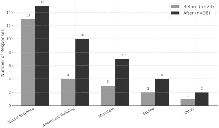
Note: Frequencies are based on \(n = 23\) (before) and \(n = 38\) (after). Source: Created by the authors based on participants’ responses to the training exercise.
Fig. 4. Comparison of recommended evacuation sites before and after the lecture.
Participants cited various reasons for their choices, often directly referencing the multi-hazard scenario presented in the training. The tunnel was perceived as the safest option because of its distance from the coastline and its assumed resistance to secondary hazards such as tsunami-induced fires, potential protection from heavy rain, and associated landslide risks. The apartment building was favored for its proximity to the school, sufficient elevation (capable of withstanding inundation from a tsunami exceeding 10 m), and critically, its low perceived landslide risk, a significant factor considering the concurrent heavy-rain warning. Moreover, the nearby mountain was appreciated for allowing staged evacuation and its relatively short distance from the school grounds, although some participants expressed concerns about exposure to heavy rain and increased landslide risk on the ascent route under the given conditions.
Participants recognized that no single evacuation site was ideal; each had strengths and weaknesses that needed to be weighed flexibly, particularly under complex multi-hazard conditions. For instance, the tunnel was the farthest from the school and required crossing inundation-prone, high-traffic roads, but its primary appeal was to provide shelter from both tsunami-induced fires and heavy rain, as indicated by the simultaneous warning, connecting to areas beyond the projected inundation zone. The private apartment building was close to the school and sufficiently tall, offering a clear vertical evacuation option when ground routes may be compromised by both inundation and rainfall-induced flooding. However, it requires prior agreement with the owner and lacks fully enclosed spaces for long-term sheltering. The mountain offered the potential for staged evacuation to higher ground and was relatively close, but its location within a landslide warning zone, particularly with the ongoing heavy rain warning, became a significant concern for participants, who also noted the exposure of evacuees to precipitation. The nearby shrine was the closest option, but similarly raised concerns about its location in a landslide hazard area under heavy rain, and lacked sufficient indoor space to accommodate all students. Through discussion and observation of the case school’s decision-making presentation during the exercise, participants began to consider distributed evacuation strategies—an important realization—particularly after recognizing the limited capacity of the school’s third floor to shelter all students during the drills. This underscores the effectiveness of training in fostering practical, context-sensitive risk analysis and flexible planning that accounts for dynamic multi-hazard scenarios.
5. Discussion
This study elucidates both the potential progress and institutional limitations of incorporating updated tsunami hazard assumptions into school-level evacuation planning through in-service teacher training in Ishinomaki City.
In May 2022, Miyagi Prefecture revised its tsunami inundation simulation, and in August 2023, Ishinomaki City updated its hazard maps and tsunami evacuation plan 24. Notably, the teacher training examined in this study was conducted in June 2023, immediately prior to the institutional revisions in Ishinomaki City. The revised plan included new “evacuation target areas” and “evacuation destination points” based on the assumption of an L2 tsunami, representing a crucial step forward in scientific knowledge.
However, while the revised plan provided reference information on estimated evacuation times, the review of evacuation facilities remained partial, and practical considerations, such as the preparedness and capacity of shelters, were not sufficiently addressed. Although the institutional framework for tsunami evacuation planning has advanced, its practical adaptability in diverse school contexts remains limited.
5.1. School-Level Autonomy vs. Municipal Uniformity: The Value of Local Adaptation
In particular, the fact that the tsunami evacuation plan was formulated at the junior high school district level presents a structural limitation in adequately reflecting the geographical characteristics of individual elementary school zones. This misalignment between municipal uniformity and local reality underscores the necessity of empowering school-level actors to critically evaluate and reinterpret centralized mandates locally. In the case of X Elementary School, the city-designated evacuation destination point was a hilltop located approximately 1.4 km away from the school and outside the school district. In contrast, based on a reconsideration of the local topography and school commuting zones, the school independently identified K Mountain, located approximately 830 m from the school, as an alternative evacuation site. Although K Mountain was not included in the official city plan, it lies outside the estimated tsunami inundation zone and was judged by the school to be a realistic evacuation destination if basic improvements were made.
This case illustrates that independent evacuation planning at the school level can yield more realistic and effective outcomes than uniform designations imposed at the municipal level. In this training program, teachers engaged in a step-by-step process using hazard maps and topographic data to analyze elevation and tsunami risk zones and evaluate potential evacuation routes and destinations. Consequently, the training provided an opportunity to re-examine evacuation strategies rooted in local realities, demonstrating the value of this approach.
5.2. The Operational Mechanism of Inaction: Institutional Constraints and Risk-Averse Coping
The designation of school buildings as tsunami evacuation buildings by the municipal government introduces a significant operational paradox in school-level evacuation planning. This designation legally mandates that the school serve as a refuge for residents, thereby expanding the school’s on-site responsibility beyond its primary duty of ensuring the safety of its own students and staff. However, our investigation (Section 4.2) revealed that the third floor of the school building, designated as a vertical evacuation site, was judged by X Elementary School as lacking sufficient capacity, even for its own students, particularly when considering the assumption that local nursery school children would also be evacuated.
To address this issue, X Elementary School adopted a strategy of dispersed evacuation, deciding to designate not only the school building, but also a nearby private apartment building as a potential tsunami evacuation building. This school-driven initiative serves as a practical supplement to official designations and highlights the importance of incorporating flexible and locally specific perspectives into future evacuation planning, such as dispersed evacuations.
This critical capacity deficit (even after adopting dispersed evacuation) illustrates the gap between institutional designation and practical feasibility. Although the school’s internal planning tends to prioritize the evacuation and safety of its students, its formal status as a community shelter compels the consideration of community evacuees (e.g., residents). This conflict highlights the inherent difficulty for schools to separate school disaster management from broader community disaster management, a situation that often stalls decisive planning.
Furthermore, under Japan’s legal framework, schools designated as “facilities for persons requiring special consideration” and located within hazard zones, as specified in a municipal disaster management plan, are required to develop evacuation assurance plans. However, they often lack adequate authority or institutional support to review or revise these plans in line with actual risks, resulting in a continued structure where schools bear disproportionate “on-site” responsibility.
Consequently, the institutional and psychological preferences for staying on site, as revealed in our baseline analysis (Section 4.1), can be understood as a rational risk-averse coping mechanism for teachers. By remaining within the designated school property, teachers prioritize minimizing the legal and institutional risks associated with deviating from official municipal mandates, even if this choice is not optimal or risk informed for life safety.
5.3. A Comparative Perspective: The Dual Paradox and Global Relevance
The structural and behavioral misalignment analyzed in Section 5.2—where responsibility is delegated to local institutions without sufficient authority or support—is a clear manifestation of what Burby termed the “paradoxes of government disaster policy” 25. This arrangement forces local entities such as teachers into a risk-averse coping mechanism that prioritizes institutional adherence over optimal life safety. This comparative analysis demonstrates that while the local expression of the “dual paradox” differs by country, ranging from institutional vacuum (Aceh) to institutional overload without empowerment (Japan), the fundamental barrier to risk-informed decision-making remains the same: a misalignment between accountability and authority.
In contrast, many countries continue to lack detailed legal or institutional capacity for hazard mapping, evacuation site designation, or official integration of updated hazard data into community evacuation plans. For example, in Aceh, Indonesia, tsunami risk assessment and hazard mapping are often led by research institutions such as the Tsunami and Disaster Mitigation Research Center (TDMRC) at Syiah Kuala University in collaboration with international partners. These assessments, using multi-scenario probabilistic tsunami hazard assessments and high-resolution inundation modeling, are provided to national agencies (BNPB), state and local disaster management offices, and community leaders, and are incorporated into evacuation training and planning exercises 26.
However, although existing laws and regulations point to local governments producing official hazard maps, the ensuing technical and institutional capacity to designate and ensure the safety and appropriateness of evacuation sites is lacking 27. Instead, information transfer, community training, and local evacuation planning occur through collaborative workshops and initiatives, which are often dependent on the technical capacity and leadership of local universities and NGOs. This has resulted in the proliferation of multiple versions of tsunami risk maps, ambiguity in the designation of evacuation sites, and what Fusinato et al. identified as a “false sense of security” among community members, including local schools 28. This phenomenon was confirmed by our survey conducted in 2014, ten years after the 2004 Indian Ocean Tsunami, targeting all elementary schools that were destroyed and subsequently rebuilt 14. This finding was initially observed in our longitudinal survey conducted in the same city in late 2024 over a 20-year span 29.
These findings from Aceh are emblematic of the Safe Development Paradox: official or semi-official hazard information and evacuation site designations, when not accompanied by clear mandates, simulation practices, or sufficient local capacity, can give rise to an illusion of preparedness. This false sense of security 28 may hinder proactive evacuation planning or undermine the perceived need for local adaptation even in high-risk areas. Although this situation in Aceh illustrates the first dimension of the paradox—overconfidence induced by formal designations—it does not fully align with the second. Local entities in Indonesia often lack both formal responsibility and institutional authority to implement evacuation planning. Thus, only one side of the “dual paradox” is present.
However, in the Japanese context, a different but more complete paradox can be observed. In Ishinomaki City, although tsunami hazard maps and overall evacuation plans were officially updated based on scientific models, the designated evacuation sites and shelters were not sufficiently reviewed. This limits the practical feasibility of evacuation, as evidenced by X Elementary School’s independent consideration of dispersed evacuation. City-designated vertical evacuation sites were found to have insufficient capacity, particularly when considering the nursery school children. Moreover, official designations do not always align with actual school commuting zones or topographic realities. This situation reflects what Burby 25 termed the paradoxes of government disaster policy, in which responsibility is delegated to local institutions—such as schools—without sufficient authority or support for effective implementation.
Therefore, the core challenge addressed by the RIDM Approach in Ishinomaki is not unique to a single locale; rather, it is a highly structural problem prevalent in many governance systems worldwide where centralized mandates clash with decentralized implementation requirements. This global relevance strongly suggests that the systematic approach to overcoming institutional and psychological biases (detailed in Section 5.2) possesses external validity for any region facing similar structural misalignments in DRR planning.
To overcome this dual paradox, school-level evacuation planning must be supported not only by updated scientific data, but also by institutional flexibility and teacher training that empower local actors to critically engage with risk information.
6. Conclusion
This study investigated how teacher training programs facilitate the integration of scientific tsunami risk information into school-based evacuation planning (RQ1), and the forms of institutional support that are necessary for teachers to assume proactive roles (RQ2).
The central academic contribution of this study is the empirical demonstration that a structured capacity-building intervention, the RIDM Approach, can successfully overcome the institutional and psychological preference for staying within school premises, which was identified as a major structural barrier.
The in-service training program examined in this study demonstrated a viable approach through which updated scientific tsunami assumptions, including revised hazard zones and evacuation principles, could be meaningfully interpreted at the school level. The targeted intervention effectively challenged the baseline decision-making tendency, achieving a significant shift toward prioritizing optimal and safer horizontal evacuation sites. This was accomplished by systematically addressing the dual operational paradox (Sections 5.2 and 5.3): first, by using multi-hazard scenarios to dismantle the false sense of security associated with vertical evacuation, and second, by leveraging peer-to-peer evidence and the institutional feedback loop to empower teachers to evaluate centralized mandates and develop risk-informed, localized plans critically.
Addressing the critique of the study’s reliance on a single case school in Ishinomaki City, we assert that the observed challenges and effectiveness of the intervention hold significant external validity for limited systemic generalization. The preference for staying on-site is not unique to this locale; rather, it is a rational, risk-averse coping mechanism prevalent among teachers across Japan who operate under a common structural misalignment (Section 5.2). The effectiveness of the RIDM Approach is based on a reproducible and structured approach designed to target this common systemic barrier. Therefore, the approach provides a blueprint applicable to any municipality or region, nationally or internationally, that faces a similar clash between centralized disaster planning and the necessity for decentralized, localized adaptation.
However, this study has several limitations. While the findings point to limited external validity by addressing a common structural paradox, the empirical evidence is derived from a single case in Ishinomaki City and requires longitudinal validation to measure sustained behavioral changes. Furthermore, the training program was externally supported by university researchers and was not embedded in the national teacher training system.
Stronger collaboration and support between local educational authorities and disaster management departments are essential to address the structural dilemmas identified in this study. The RIDM Approach demonstrates that systematic teacher training is not merely a capacity-building tool reliant on specialist knowledge, but an indispensable institutional mechanism that enables the transformation of scientific knowledge into effective school-based evacuation practices. These findings offer a clear policy blueprint for municipalities facing similar structural misalignments between centralized and decentralized implementation needs.
Acknowledgments
This work was supported by the Disaster Resilience Co-creation Center, IRIDeS, Tohoku University.
- [1] W. Adiyoso and H. Kanegae, “The effect of different disaster education programs on tsunami preparedness among schoolchildren in Aceh, Indonesia,” Disaster Mitigation of Cultural Heritage and Historic Cities, Vol.6, pp. 165-172, 2021.
- [2] J. León, P. A. Catalán, and A. Gubler, “Assessment of top-down design of tsunami evacuation strategies based on drill and model led data,” Frontiers in Earth Science, Vol.9, Article No.744193, 2021. https://doi.org/10.3389/feart.2021.744193
- [3] G. Nakano and K. Yamori, “Disaster risk reduction education that enhances the proactive attitudes of learners: A bridge between knowledge and behavior,” Int. J. of Disaster Risk Reduction, Vol.66, Article No.102620, 2021. https://doi.org/10.1016/j.ijdrr.2021.102620
- [4] T. Katada and M. Kanai, “The school education to improve the disaster response capacity: A case of ‘Kamaishi Miracle’,” J. Disaster Res., Vol.11, No.5, pp. 845-856, 2016. https://doi.org/10.20965/jdr.2016.p0845
- [5] N. Wood, J. Jones, J. Schelling, and M. Schmidtlein, “Tsunami vertical-evacuation planning in the U.S. Pacific Northwest as a geospatial, multi-criteria decision problem,” Int. J. of Disaster Risk Reduction, Vol.9, pp. 68-83, 2014. https://doi.org/10.1016/j.ijdrr.2014.04.009
- [6] E. Mas, B. Adriano, and S. Koshimura, “An integrated simulation of tsunami hazard and human evacuation in La Punta, Peru,” J. Disaster Res., Vol.8, No.2, pp. 285-295, 2013. https://doi.org/10.20965/jdr.2013.p0285
- [7] K. Kim, F. Kaviari, P. Pant, and E. Yamashita, “An agent-based model of short-notice tsunami evacuation in Waikiki, Hawaii,” Transportation Research Part D: Transport and Environment, Vol.105, Article No.103239, 2022. https://doi.org/10.1016/j.trd.2022.103239
- [8] A. Takahashi and K. Yasufuku, “Evaluation of tsunami evacuation plans for an underground mall using an agent-based model,” J. Disaster Res., Vol.19, No.2, pp. 268-278, 2024. https://doi.org/10.20965/jdr.2024.p0268
- [9] Y. Goto, M. Affan, Agussabti, Y. Nurdin, D. K. Yuliana, and Ardiansyah, “Tsunami evacuation simulation for disaster education and city planning,” J. Disaster Res., Vol.7, No.1, pp. 92-101, 2012. https://doi.org/10.20965/jdr.2012.p0092
- [10] F. Russo and C. Rindone, “Methods for risk reduction: Training and exercises to pursue the planned evacuation,” Sustainability, Vol.16, No.4, Article No.1474, 2024. https://doi.org/10.3390/su16041474
- [11] M. Radestad, C. Holmgren, E. L. Blidegård, and K. L. Montán, “Use of simulation models when developing and testing hospital evacuation plans: A tool for improving emergency preparedness,” Scandinavian J. of Trauma, Resuscitation and Emergency Medicine, Vol.31, No.1, Article No.43, 2023. https://doi.org/10.1186/s13049-023-01105-w
- [12] United Nations Office for Disaster Risk Reduction (UNDRR), “Sendai Framework for Disaster Risk Reduction 2015–2030,” 2015. https://www.undrr.org/publication/sendai-framework-disaster-risk-reduction-2015-2030 [Accessed July 10, 2025]
- [13] Global Alliance for Disaster Risk Reduction and Resilience in the Education Sector (GADRRRES), “Comprehensive school safety framework 2017,” 2017.
- [14] I. Rafliana, “Disaster education in Indonesia: Learning how it works from six years of experience after Indian Ocean tsunami in 2004,” J. Disaster Res., Vol.7, No.1, pp. 83-91, 2012. https://doi.org/10.20965/jdr.2012.p0083
- [15] A. Sakurai, M. B. F. Bisri, T. Oda, R. S. Oktari, Y. Murayama, Nizammudin, and M. Affan, “Exploring minimum essentials for sustainable school disaster preparedness: A case of elementary schools in Banda Aceh City, Indonesia,” Int. J. of Disaster Risk Reduction, Vol.29, pp. 73-83, 2018. https://doi.org/10.1016/j.ijdrr.2017.08.005
- [16] Intergovernmental Oceanographic Commission of UNESCO (UNESCO/IOC), “Tsunami Ready Recognition Guidelines,” 2023.
- [17] S. J. Scheer, V. Varela, and G. Eftychidis, “A generic framework for tsunami evacuation planning,” Physics and Chemistry of the Earth, Vol.49, pp. 79-91, 2012. https://doi.org/10.1016/j.pce.2011.12.001
- [18] Okawa Elementary School Tsunami Incident Investigation Committee, “Report on the Okawa Elementary School tsunami incident,” Ishinomaki City Board of Education, 2014 (in Japanese).
- [19] A. Sakurai, “School safety management: International framework and Japanese practice,” Y. Jing, J.-S. Han, and K. Ogawa (Eds.), “Risk Management in East Asia,” pp. 167-195, Palgrave Macmillan, 2021. https://doi.org/10.1007/978-981-33-4586-7_8
- [20] Ministry of Education, Culture, Sports, Science and Technology (MEXT), “The Third Basic Plan for the Promotion of School Safety (2022–FY2026),” Cabinet Decision, March 25, 2022 (in Japanese). https://www.mext.go.jp/a_menu/kenko/anzen/index.htm [Accessed July 10, 2025]
- [21] Miyagi Prefecture, “Publication of tsunami inundation assumptions in Miyagi Prefecture,” 2022 (in Japanese). https://www.pref.miyagi.jp/soshiki/kasen/miyagi-tsunami-shinsuisoutei-published1.html [Accessed July 10, 2025]
- [22] MEXT, “Notice on the development of evacuation securing plans and implementation of drills related to tsunami response based on the act on tsunami disaster prevention regional development,” 2019 (in Japanese). https://www.mext.go.jp/a_menu/kenko/anzen/1422067.htm [Accessed July 10, 2025]
- [23] A. Sakurai, T. Oda, Y. Murayama, and T. Sato, “Linking geomorphological features and disaster risk in a school district: The development of an in-service teacher training programme,” IOP Conf. Series: Earth and Environmental Science, Vol.630, No.1, Article No.012108, 2021. https://doi.org/10.1088/1755-1315/630/1/012108
- [24] Ishinomaki City, “Ishinomaki City tsunami evacuation plan,” 2023 (in Japanese).
- [25] R. J. Burby, “Hurricane Katrina and the paradoxes of government disaster policy: Bringing about wise governmental decisions for hazardous areas,” Annals of the American Academy of Political and Social Science, Vol.604, pp. 171-191, 2006. https://doi.org/10.1177/0002716205284676
- [26] Ibrahim, Syamsidik, Azmeri, M. Hasan, A. Irwansyah, and M. D. Al Farizi , “Assessing tsunami vertical evacuation processes based on probabilistic tsunami hazard assessment for west coast of Aceh Besar, Indonesia,” Geoenvironmental Disasters, Vol.10, Article No.8, 2023. https://doi.org/10.1186/s40677-023-00238-5
- [27] G. Strunz et al., “Tsunami risk assessment in Indonesia,” Natural Hazards and Earth System Sciences, Vol.11, pp. 67-82, 2011. https://doi.org/10.5194/nhess-11-67-2011
- [28] E. Fusinato, S. Han, M. Kobiyama, and M. M. de Brito, “Safe development paradox: Evidence and methodological insights from a systematic review,” Natural Hazards, Vol.120, pp. 13693-13714, 2024. https://doi.org/10.1007/s11069-024-06774-z
- [29] A. Sakurai, M. B. E. Bisri, B. Meidinger, and R. S. Oktari, “Two decades after the Indian Ocean Tsunami: Assessing school disaster preparedness in Banda Aceh,” AIWEST-DR 2025 Book of Abstract, p. 61, 2025.
This article is published under a Creative Commons Attribution-NoDerivatives 4.0 Internationa License.