Survey Report:
Developing and Implementing a Disaster Prevention Game to Enhance Local Understanding
Miri Shirokane†, Airi Yamada, Ryo Misawa, and Nobuhisa Matta

Okayama University
3-1-1 Tsushimanaka, Kita-ku, Okayama, Okayama 700-8530, Japan
†Corresponding author

This study developed and implemented a local disaster prevention sugoroku-style game to address challenges in preserving and transmitting regional knowledge in areas with high population mobility. Many Japanese communities face both natural and social vulnerabilities, and effective disaster education requires linking hazard knowledge with local characteristics. Conducted at Sonan Junior High School in Okayama, the project combined lectures, workshops, and a community engagement event. Students learned about regional topography, land use, and disaster history and used this knowledge to design quizzes, rules, and disaster scenarios for the game. The final sugoroku set included a map-based board, thematic quiz areas, and preparedness item cards, enabling players to predict damage and consider appropriate actions. After creating the game, students shifted from identifying familiar landmarks to describing concrete disaster impacts such as liquefaction or infrastructure collapse. Interaction with local residents further enriched learning through shared experiences. The model proved feasible in terms of time and cost, and its structure is easily adaptable to other regions by incorporating local information. The findings suggest that this participatory, place-based approach enhances imagination, self-efficacy, and intergenerational knowledge transfer, contributing to community-wide disaster preparedness. Future studies will examine long-term educational impacts and broader regional applications.
Disaster game made with students
1. Introduction
1.1. Background of Disaster Prevention Game Development
Many countries worldwide, including Japan, are at risk from natural disasters, and human behavior during disasters plays a key role in determining their magnitude. Furthermore, the scale of damage is significantly influenced not only by the magnitude of the natural phenomenon itself, but also by regional characteristics, such as the geographic and social vulnerabilities of the affected area. Therefore, a thorough understanding of regional characteristics is essential for effective disaster prevention and mitigation measures. Considering this background, disaster prevention education, which guides residents in appropriate decision-making and actions, is considered a fundamental priority for protecting human lives and societal safety. Disaster prevention education significantly contributes to improving initial responses by promoting independent decision making and strengthening mutual assistance within communities. Typical examples include the “Kamaishi Miracle” during the 2011 Great East Japan Earthquake, where sustained school-based disaster education fostered autonomous evacuation behavior among students 1, as well as the “voluntary evacuation before the tsunami warning” during the 2024 Noto Peninsula Earthquake.
However, in Japan, a trend of dispersal of hometowns across generations has been established, beginning with large-scale population movements during periods of rapid economic growth. This trend has been compounded by various migration patterns, including those associated with job transfers, higher education, and the I-turn migration. In urban and suburban areas, with a particularly high proportion of immigrants, a social structure has emerged in which local traditions and disaster-related experiences struggle to be transmitted across generations.
Recognizing this issue, we developed a local disaster prevention game as an educational method to promote understanding of regional characteristics. We combined local learning content such as topography, land use, and water systems with participatory game elements that involve creating action plans based on assumed disaster situations and designed a learning structure that translates knowledge into situational judgment and behavioral intention. This study is grounded in the principles of place-based education and disaster risk reduction pedagogy, which emphasize the integration of local environmental knowledge and experiential learning. This study aims to present a reproducible educational model that can be applied across different local areas. This study reports on the implementation process and results obtained.
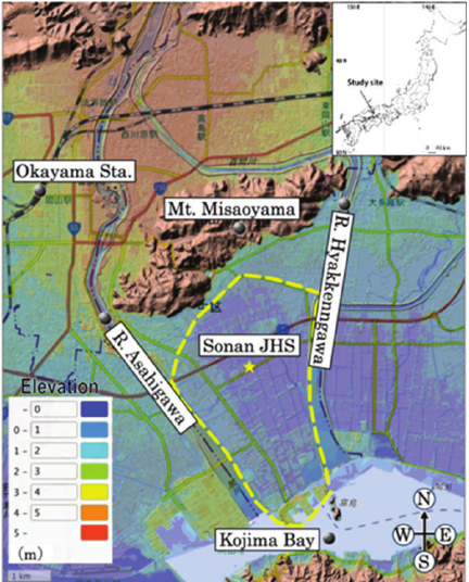
Fig. 1. Survey area. Sōnan Junior High School district topographic map.
1.2. Overview of the Participating School
This study was conducted at Sonan Junior High School in Okayama (Fig. 1). School districts have undergone rapid residential development since the 1970s, resulting in a high number of immigrants from other areas. Consequently, local traditions and disaster experiences are not easily shared across generations, making it difficult to form and maintain local communities. This is a common characteristic of urban and suburban areas that experience large-scale population movements and contributes to the weakening of mutual assistance during disasters. Moreover, the Sonan Junior High School District faces a high disaster risk owing to its natural conditions. The district is surrounded by the Misaoyama Mountain Range to the north, Asahigawa River to the west, Hyakkenngawa River to the east, and Kojima Bay to the south. The low-lying land enclosed by these features is Okishinden, a land reclamation project established during the Edo period. Owing to its soft ground, the area is at high risk of liquefaction in the event of a major Nankai Trough earthquake. Significant liquefaction damage was recorded in this area during the 1946 Showa Nankai Earthquake. Thus, school districts are typical areas where social and natural vulnerabilities overlap, making them suitable sites for implementing disaster prevention education.
2. Method
The authors improved the disaster prevention game through three pilot trials. All trials were conducted in junior high schools in the Okayama Prefecture: the first at Okayama Municipal Tomiyama Junior High School in 2022, the second at Takahashi Municipal Takahashi Junior High School in 2023, and the third at Okayama Municipal Sonan Junior High School in 2024. This study details the results of the third and final trials. Moreover, we examined changes in students’ understanding using free-form questionnaires before and after the activity.
2.1. Reasons for Selecting the Sugoroku Format
We selected sugoroku as the game format to ensure that the same process could be used in every region to create teaching materials that enhance regional understanding. The three reasons for this were as follows. First, sugoroku is a board game. By presenting a map on the game board, participants can see the spatial structure of the region, including hazard maps, topographic information, and road information. This allows the participants to experience the situation while connecting it to a concrete spatial image, thereby promoting experiential learning. Second, sugoroku has simple rules. Simple game rules reduce the learning burden and simplify it for players to immerse themselves in an activity, potentially enhancing their intrinsic motivation. In contrast, complex, uniquely designed games require time to master and may lead to a decline in motivation before learning objectives are achieved. Furthermore, the game rules shared across generations can be played together to provide a platform for regional traditions. Third, sugoroku has a pattern that can be easily imitated and modified. The board design, squares, and cards can be replaced, making them versatile and reconfigurable for each region. Based on these points, we determined that the sugoroku format was the most suitable for this study.
2.2. Sugoroku Set Production Procedure
This teaching materials comprise a board that accurately reflects the area’s topographical information and cards that allow players to simulate a disaster response. To create the board, we first obtained topographical data for the Sonan Junior High School District from the National Land Digital Information System and used QGIS to create a color-coded elevation map at a scale that allowed players to view individual residences. Next, we used Illustrator to create grids on the elevation map and combined two A1-sized sheets to create the board. The cards included disaster preparedness item cards (such as flashlights and emergency food) and mutual aid cards (allowing players to answer questions). The cards were hand-designed and printed according to the business card size. Further, we downloaded a hazard map for Sonan Junior High School district from the Okayama City website, printed it on a transparent sheet, and placed it on top of the board. A rulebook outlining the game instructions and sample quiz answers was created using Word.
Table 1. Overview of disaster prevention education activities.

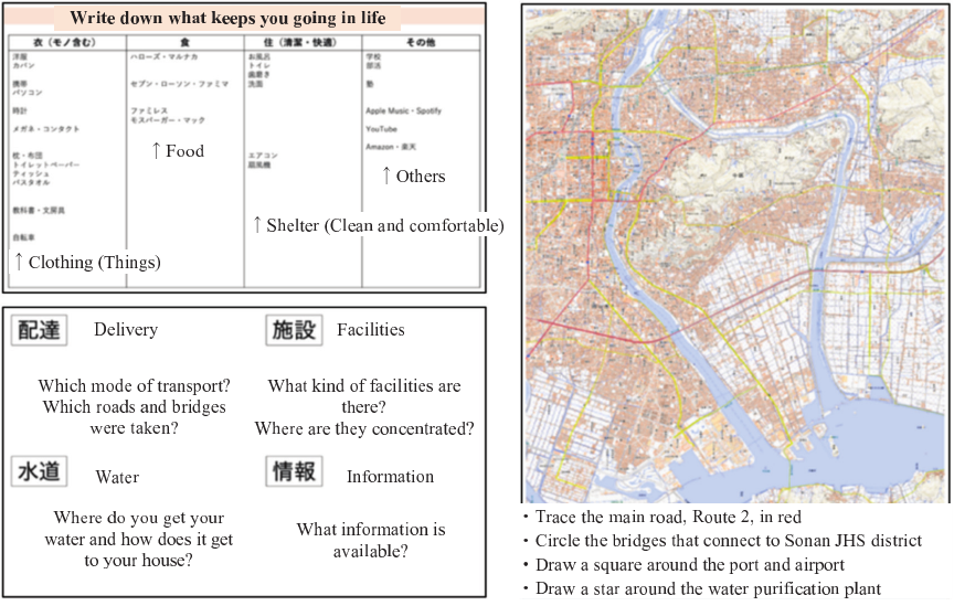
Fig. 2. Worksheet for focus on infrastructure.
2.3. Sugoroku Production Workshop and Community Exchange Event
In this study, rather than using conventional general disaster knowledge, we aimed to use disaster knowledge specific to a region as the subject matter, allowing participants to imagine damage that directly relates to their own lives. Therefore, to help participants understand disasters as a result of the interaction between natural and social conditions, learning activities were organized based on the following five points: (1) understanding the mechanisms underlying disaster occurrence; (2) learning about the formation of the region, its topography, and land use; (3) investigating past disaster case; (4) focusing on the social conditions and infrastructure that support the foundations of life; and (5) specifically imagining the damage caused by infrastructure collapse.
These points provide core knowledge and perspectives for creating a disaster prevention sugoroku game. The specific implementation procedures and content are listed in Table 1.
Fifteen individuals participated in the workshop, with each group comprising five members. In addition to junior high school students, 22 local residents participated in the event.
3. Result
3.1. Results of Developing Disaster Prevention Sugoroku
Before creating the disaster prevention board game, the students were limited to describing the locations of nearby buildings, however, after creating the game, they began to describe specific damage scenarios, such as “subsidence of utility poles and houses,” “rising manholes,” and “traffic congestion due to damaged roads” (Fig. 3). Feedback included comments such as “It was an opportunity to research things that we do not normally learn,” and “It was fun to create my own questions that were typical of Sonan.”
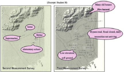
Fig. 3. Disaster preparedness game development: pre- and post-assessment of disaster impact prediction skills (excerpt: Student H).
3.2. Structure and Function of the Sugoroku Set
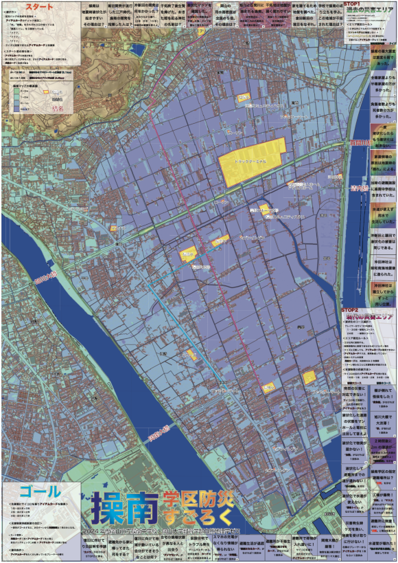
The disaster prevention sugoroku developed in this study uses a regional map on the game board to encourage damage predictions tailored to regional characteristics and translate knowledge into concrete action scenarios. It comprises four elements: (1) a map-based board; (2) a set of quiz squares comprising three learning areas; (3) item cards that simulate disaster preparedness; and (4) a team-based game system led by a game master. Players learn about the region’s history, disasters, and current hazards by moving through the squares on the periphery of the board and acquire experiential understanding of how to respond to a disaster by acquiring items.
The board uses a map of the target area, allowing players to visually grasp the terrain and road information. To avoid obscuring the center of the map, squares were placed on the periphery, allowing players to continually refer to geographic information during the game (an idea proposed by students at Sonan Junior High School). A hazard map of Okayama City was overlaid on the game board, allowing players to view evacuation routes and dangerous areas as they progressed through the game. This structure enables players to learn while obtaining an overview of the entire process, from pre-disaster to recovery (Fig. 4).
The squares were divided into three areas: the “Regional History Area,” “Past Disaster Area,” and “Modern Disaster Area.” They featured quizzes designed by junior high school students participating in a workshop that considered the characteristics of each region. The regional history covers the history of land reclamation and land conditions. The past disaster area covered damage caused by the 1946 Showa Nankai Earthquake. Modern disaster areas cover potential damages specific to each region, such as road damage caused by liquefaction and the spread of fires. These were arranged in chronological order, allowing learners to understand the region’s history and current risks in a continuous manner (Fig. 4).
In addition, item cards that could be earned by correctly answering specific questions were introduced. These included a “flashlight” useful in the event of a power outage and a “portable camera” to record the necessary documentation for disaster damage certification, encouraging players to visualize specific actions to take in the modern disaster area. These items were designed to favor action choices in modern disaster areas. The players’ experiences, in which the presence or absence of items affected the outcome of their actions, allowed them to understand how useful each preparation was (Fig. 5).
Regarding the operation, a single game master was assigned to judge the answers, and the players operated one piece in pairs. This allowed the thought process underlying the quiz to be shared naturally, and the content was repeated when multiple teams landed in the same square. As described above, the sugoroku game combines damage prediction through quizzes with the experience of preparation through item cards and is designed to comprehensively support disaster prevention learning based on the geographical characteristics of the region.
3.3. Time and Cost Required for Implementation
The total time required for the event, including the lecture and workshop, was approximately 300 minutes. The cost of the teaching materials for this event was approximately 75,000 yen, as the board was produced with a high-quality design.
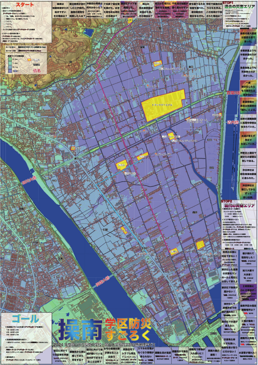
Fig. 4. The completed game board.

Fig. 5. Item cards.
3.4. Results of Local Exchange
During these activities, local residents shared their experiences of disasters and disaster prevention knowledge. Participating residents commented, “I was able to observe the history of the area and learn about the problems faced in the area,” and “The quiz content was educational, and it helped me to increase my interactions with local people, which will be useful in improving disaster prevention capabilities.”
4. Discussion
4.1. The Educational Significance of Disaster Prevention Sugoroku
Students acquired the ability to link regional characteristics to disasters and make predictions, suggesting that they had actively reconstructed their local knowledge. However, prior to creating the disaster prevention game, they had attended training at The Great Hanshin-Awaji Earthquake Memorial Disaster Reduction and Human Renovation Institution, but had learned only about the locations of familiar buildings. Despite students learning about liquefaction risk through traditional disaster prevention education, connecting this knowledge to everyday life issues and evacuation behaviors is difficult. This suggests that disaster prevention training alone may not be sufficient to effectively anchor knowledge in local areas. The developed regional disaster prevention game is likely to be a teaching tool that contributes to the development of imagination and a sense of self-efficacy, which are limited in traditional knowledge transfer education.
4.2. Community Center Activities and Improving Local Disaster Prevention Capabilities
Local residents have a strong sense of familiarity with the area from living there for many years and the advantage of being able to recall roads and facilities in concrete terms in the event of a disaster. Through their interactions with local residents, junior high school students were able to learn about the experiential knowledge that had been embedded in the community. An example of this intergenerational exchange, which extends disaster prevention education beyond schools and helps strengthen the disaster prevention capabilities of the entire community, is that disaster prevention education delivered to elementary school students has been reported to spread to parents and encourage disaster prevention actions 2. Similarly, the community center activities in this study have the potential to strengthen the awareness and behavior of local residents through students. Thus, by involving local residents and developing disaster prevention education through intergenerational exchange rather than confining it to schools, disaster prevention education is expected to lead to improvements in the disaster prevention capabilities for the entire community.
4.3. Significance as a Highly Feasible Disaster Prevention Education Model
This development process demonstrated feasibility in terms of class time, teaching materials, and preparation costs. Furthermore, by incorporating region-specific adaptations into a region’s unique topography, water systems, and disaster history, this method can be deployed as a universal and reproducible educational model.
However, there are several prerequisites for replication. First, the study area had sufficient hazard data, such as detailed hazard and flood risk maps created by the local government, which allowed the data to be rapidly incorporated into the teaching materials. However, developing and implementing a similar disaster prevention sugoroku game may be difficult in areas lacking such basic data. Second, regarding collaboration with the local government, the community center was cooperative in coordinating the schedule and securing the venue, which facilitated the event smoothly. Furthermore, Takeshima, a teacher, proactive role in coordinating school-based implementation was a key factor in ensuring smooth operation.
With these conditions in place, the process of students researching local history and past disaster cases became a learning experience, enhancing their ability to anticipate damage. Teachers’ central role is to provide conceptual instruction that helps students understand that disasters occur because of the interactions between natural and social conditions. Once this foundation is established, students will be able to predict damages based on local characteristics, making this educational model applicable to other regions. However, preparation and adjustments based on the implementation conditions and regional differences are essential, and these are important points that require further discussion when considering generalizability.
5. Conclusion
This project was introduced to address the difficulty of preserving and transmitting local traditions in areas with large immigrant populations. A disaster prevention game was developed and implemented to link community-based learning with disaster prevention education. The objectives were to increase the local understanding and provide a forum for connecting children, parents, and the community. The game enabled specific damage predictions based on local characteristics, such as liquefaction and house collapse. Furthermore, activities at community centers confirmed knowledge transfer through intergenerational exchange, suggesting the possibility of improving disaster preparedness in the entire region.
However, this study was limited by its single-site design and short-term evaluation. Therefore, further research across multiple regions is required. Future research should conduct larger-scale, long-term studies to verify the sustainability of the educational impacts of converting damage predictions based on local characteristics into behavioral intentions. Moreover, future studies should examine how implementation in other regions can generate broader ripple effects on local disaster prevention capabilities and promote the implementation of sustainable disaster prevention education in local communities.
Acknowledgments
We hereby express our sincere thanks to Teacher Jun Takeshima and all the school personnel concerned with Okayama Municipal Sonan Junior High School who kindly cooperated with us in conducting this study. We also thank Mr. Yuki Ikeda, who cooperated with us in data analysis. This study summarizes some of the PBL activities in the Okayama University Graduate School Education Graduate Course majoring in Education Science. We have also added that we will publish part of this study’s results at the Planet Earth Science Association 2025 and at the Regional Geography Society 2025. The cost of developing the teaching materials has been aided by the Okayama City Policy Bureau Policy Planning Department’s “Reiwa 6 Fiscal Year Students Innovation Challenge Promotion Project.” In addition, this study has been supported in part by the Grants-in-aid for Scientific Research of the Japan Society for the Promotion of Science: “Challenging Research (Exploratory)” (Subject No. 22K18507, Research Representative: Nobuhisa Matta). This study was supported by the Ministry of Education, Culture, Sports, Science and Technology of Japan under “The Third Earthquake and Volcano Hazards Observation and Research Program.”
- [1] T. Katada and M. Kanai, “The school education to improve the disaster response capacity: A case of ‘Kamaishi Miracle,’ ” J. Disaster Res., Vol.11, No.5, pp. 845-856, 2016. https://doi.org/10.20965/jdr.2016.p0845
- [2] J. Toyosawa, K. Karasawa, and N. Fukuwa, “Effects of disaster education for elementary school children on their guardians’ disaster preparedness action: Changes in children’s affect and cognition,” Japanese J. of Educational Psychology, Vol.58, No.4, pp. 480-490, 2010 (in Japanese). https://doi.org/10.5926/jjep.58.480
This article is published under a Creative Commons Attribution-NoDerivatives 4.0 Internationa License.