Paper:
Depopulated Fishing Village Under the Prediction of a Nankai Trough Earthquake: Social Vulnerability and High Ground Relocation Planning in Taiki-cho, Mie Prefecture
Kenji Muroi†, Makoto Takahashi
 , and Keiichi Tadokoro
Nagoya University
Furo-cho, Chikusa-ku, Nagoya, Aichi 464-8601, Japan
†Corresponding author

Japan’s disaster prevention law focuses on hazard countermeasures, but not on vulnerability. However, fishing villages expected to suffer damage from a Nankai Trough earthquake have a markedly declining and aging population, and earthquake countermeasures must be considered from a sustainability perspective. Based on this idea, this study presents an interdisciplinary analysis of the current state of disaster risk reduction (DRR) in a depopulated fishing village, using the Nishiki district of Taiki-cho, Mie Prefecture as a case study. The chief findings are as follows. First, we verified that the advanced tsunami evacuation measures promoted by the town authorities in Taiki-cho since the 1990s would be effective even in the event of a “maximum-class” Nankai Trough earthquake. Second, a disconnect exists between such tsunami countermeasures and conventional community-based DRR. We revealed that the former DRR in Nishiki used to be linked to the livelihoods of the local community; however, external development dismantled this system, leading to a transition toward tsunami-specific measures led by the town authorities. Third, considering the background of extreme depopulation and aging in Nishiki in recent years, a plan was formulated to relocate elderly people to higher ground in advance. Based on an analysis of residents’ opinions of this plan, we examined the relationship between future DRR and the sustainability of local communities in depopulated fishing villages.
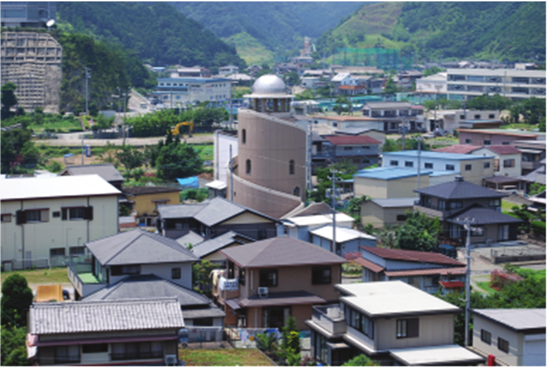
Nishiki Tower in Taiki-cho
1. Research Interests
Under Japanese disaster prevention laws, disasters are assumed to be natural phenomena (hazards). The Basic Act on Disaster Management defines a disaster as damage caused by an abnormal natural phenomenon (and some human-caused accidents). Therefore, the focus of disaster prevention is on emergency evacuation measures against hazards, which emphasize the development of voluntary disaster management organizations, evacuation drills, and various types of stockpiles 1,2. Another pillar of disaster prevention is structural deterrence measures, which are defined by laws different from the Basic Act on Disaster Management (e.g., the Coastal Law for the Construction of Seawalls). However, these civil engineering measures also share the common characteristic that an anticipated disaster is a hazard. In Japan, disaster prevention is distinguished by an emphasis on hazard-focused countermeasures.
The framework for disaster risk reduction (DRR) research is largely regulated by the aforementioned disaster prevention schemes. In Japan, disaster education usually involves improving the scientific understanding of hazards. The social sciences are often expected to play an outreach role in scientific expertise. The 2024 Journal of Disaster Research (JDR) included a special issue on “literacy for disaster resilience,” and many of the articles published in the issue also focused on educating the public about the scientific understanding of hazards and the psychological determinants of emergency evacuation 3,4,5,6,7. In the field of sociology, research on “kyo-jo” (mutual aid), disaster volunteerism, and the integration of disaster prevention and welfare as a norm has been active since the Great Hanshin Earthquake 8; however, this too is based on the implicit assumption of hazard countermeasures and relies on the existing framework of disaster prevention laws.
However, mainstream disaster research today focuses on the social causes of natural disasters. Early sociological studies of disasters that focused on human behavior in the emergency period immediately after a disaster 9,10 were criticized for overlooking the social structural context that leads to disasters, and the need to critically rethink “why disasters happen” as a precondition for “how to respond to disasters” came to be asserted 11,12,13. The occurrence and manifestation of disasters are not only determined by natural hazards, but are also regarded as the historical product of developmental land-use changes and the associated socioeconomic disparities and inequalities. Such social aspects of disasters are defined as “vulnerability” and have become a key concept in disaster research 14.
Viewing disasters not as sudden unusual events but as social trends during normal times will become increasingly important as the effects of climate change are considered in the future. Over 30 years ago, Gilbert White argued that disasters and environmental change should not be separated, and that the norm for DRR would be not only “safety” but also “sustainability” 15; and the reality is that this is exactly what is going on.
In the Japanese context, in parallel with global climate change, population decline and underuse of natural resources owing to low fertility and aging populations are becoming increasingly important new causes of disasters with serious implications for local sustainability 16,17. However, research on DRR that considers these trends remains insufficient.
Based on these considerations, this study aims to strengthen our understanding of the relationship between DRR and rural sustainability in the context of depopulated fishing villages. This case study focuses on the Nishiki district of Taiki-cho, Mie Prefecture, Japan. Nishiki is a fishing village facing severe depopulation and aging, appearing on lists of “disappearing communities” 18, while also being likely to suffer significant damage in the event of a Nankai Trough earthquake. The local characteristics of Nishiki align with our research interests.
Regarding the research methods, we adopted an interdisciplinary approach. To elucidate the relationship between DRR and sustainability, collaboration between the scientific approach to hazards and the social science approach to vulnerability is indispensable. Based on this idea, Muroi (a sociologist), Takahashi (a geographer), and Tadokoro (a seismologist) visited Nishiki district several times together, conducted collaborative field research from different viewpoints, and discussed the area’s hazard risks, countermeasures, and socioeconomic sustainability. The significance of this study lies in its attempt to examine the discrepancy between hazard risk management and rural sustainability, as well as the possibility of reconciling them based on interdisciplinary research conducted in a shared field.
This study presents the following findings. Section 2 examines the seismic and tsunami risks in Nishiki as well as the effectiveness of tsunami countermeasures from the perspectives of seismology and geography. Section 3 analyzes livelihoods, social organizations, disaster subcultures, and historical changes in Nishiki from a sociological perspective. Section 4 analyzes how the elderly residents perceive the town’s recent relocation plan for them to higher ground in advance. In the final section, based on the research findings thus far, we present a few policy proposals regarding DRR in depopulated fishing villages.
2. Tsunami Risk and Countermeasures in Nishiki
2.1. Overview of Nankai Trough Earthquake Countermeasures and Tsunami Risk in Nishiki
This section discusses the tsunami risk of a possible Nankai Trough earthquake in the Nishiki district of Taiki-cho from a seismological perspective. As a premise for this discussion, we first review national policy trends regarding Nankai Trough earthquake countermeasures. The 2011 Tohoku-Oki Earthquake (Great East Japan Earthquake) far exceeded expectations in terms of earthquake scale and tsunami damage. Considering this massive earthquake, the Central Disaster Prevention Council of the Cabinet Office compiled a scenario of “maximum class” earthquakes and tsunamis in 2012. However, the next Nankai Trough earthquake may not necessarily be the largest earthquake class. Based on scientific knowledge, the largest earthquake that could occur along the Nankai Trough in the future is called a “maximum-class earthquake,” and its frequency of occurrence is considered to be extremely low.
Nevertheless, the significance of considering the largest class of earthquakes and tsunamis is to eliminate unforeseen events and promote efficient disaster prevention and mitigation measures. Owing to the diversity of earthquake occurrence patterns in the Nankai Trough 19, predicting the exact type of earthquake that will occur based on current scientific knowledge is difficult. However, it would be inefficient for the government to establish multiple countermeasures against Nankai Trough earthquakes with various modes of occurrence, each of which would have a different magnitude. Therefore, disaster prevention and mitigation measures have been promoted based on the idea that although their frequency of occurrence is extremely low, the largest earthquakes and tsunamis that can cause extensive damage should be addressed if they do occur. Here, we focus particularly on the “Act on Development of Areas Resilient to Tsunami Disasters,” enacted in 2011.
Under the “Act on Development of Areas Resilient to Tsunami Disasters,” prefectural governors are required to set and announce the areas and depths of possible tsunami inundation (tsunami inundation assumptions) based on the “Basic Guidelines” formulated by the Ministry of Land, Infrastructure, Transport and Tourism (MLIT) in 2011, and notify the mayors of related cities, towns and villages. These basic guidelines state that a tsunami caused by a maximum-class earthquake should be assumed in the Nankai Trough area as well as in other areas.
Furthermore, municipalities are allowed to formulate a “plan for comprehensively promoting the creation of a tsunami disaster resilient community (promotion plan)” upon notification of the tsunami inundation assumption by prefectural governors. To facilitate creating this promotion plan, MLIT has developed the “Guidelines for Creating Tsunami Disaster Resilient Community Development Promotion Plans.” The guidelines emphasize the importance of not only DRR perspectives, such as the assumption of the largest class of tsunamis and multiple protections, but also community development and cooperation with residents and businesses.
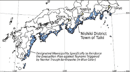
Note: Areas marked in blue color are designated municipalities specifically to reinforce the evacuation plan against tsunami triggered by Nankai Trough Earthquake. Source: policy documents on “Measures Against a Nankai Trough Earthquake” of the Cabinet Office, Government of Japan (accessed August 20, 2025), and the Digital National Land Information of Japan.
Fig. 1. Location of Nishiki district, Taiki-cho.
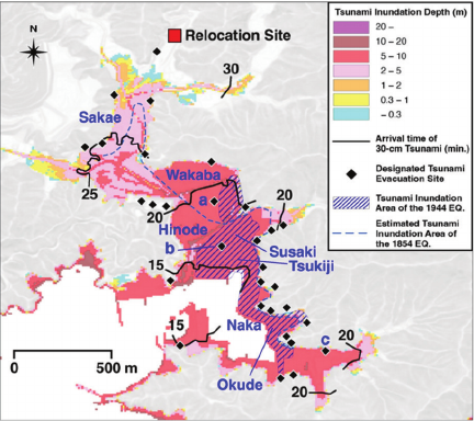
Note: a: Nishiki Tower, b: 2nd Nishiki Tower, c: Former Nishiki Junior High School. Created by QGIS based on the MLIT’s “National Land Survey (tsunami inundation assumption data),” the Geospatial Information Authority of Japan’s “Designated Emergency Evacuation Site Data,” and the Oki-cho Nishiki District Tsunami Hazard Map. Tsunami inundation and washout areas during the 1944 Showa Tonankai Earthquake are from 21; inundation areas in 1854 (during the Ansei earthquake) are estimated from the hand-drawn map in 20. The background is based on Geographical Survey Institute tiles (slope gradation map).
Fig. 2. Assumed tsunami inundation by the largest class Nankai Trough earthquake 24 and designated emergency evacuation sites for tsunamis.
The Nishiki district of Taiki-cho, the focus of this study, has a population of approximately 1,500 people and 750 households (in 2020) and is located at the bottom of a small valley at the end of a bay on an intricate coastline facing the Pacific Ocean (Fig. 1).
Before World War II, Nishiki was an independent municipality; however, after municipal mergers in the Showa and Heisei eras, it became a district of Taiki-cho. However, even after the merger, Nishiki remains the only coastal area in the town, and the town’s Disaster Prevention and Safety Division is located at the Nishiki Branch Office of the Taiki-cho Town Hall.
Nishiki, located within the anticipated source area of the Nankai Trough earthquake, has been struck repeatedly by earthquakes and tsunamis. According to historical documents, the area between Tsukiji and Okuide, facing Nishiki Bay, suffered tsunami damage, such as loss of houses and flooding, even during the Ansei (1854) and Showa Tonankai (1944) earthquakes, which were much smaller than the maximum-class earthquake 20,21 (Fig. 2).
During the Ansei Tsunami, the “Tsunami Brief Diary” records that “a tsunami was generated, rising over 6 meters above the shoreline,” and that “it was impossible to distinguish between the town and the sea” 22. In addition, the record at Nishiki Shrine describes that “80%–90% of the village was swept away by the tsunami” 20. The Hoei Earthquake (1707), the largest Nankai Trough earthquake to date, is described in the “Ugura-son-shi” as ”the entire area from seashore of Nishiki to Omari was swept away without trace” 23.
Although the “Tonankai Earthquake” of the Showa period was the smallest earthquake in the Nankai Trough known to date, Nishiki was hit by a tsunami approximately 6 m high, resulting in the death of 64 people and the destruction of 447 houses.
In the case of the maximum-class Nankai Trough earthquake, the coastal center of Nishiki is expected to be inundated to a maximum depth of 10 m 24 (Fig. 2). Inundation depth is the water level measured from the ground at a location and is different from sea level or elevation; a 10-meter inundation depth is equivalent to the height at which the third floor of a building is submerged. In Nishiki, settlements have been formed in the inland areas of the northern part of the city. Although these villages appear to be safe from tsunamis because they are located on hillsides, they have a maximum inundation depth of approximately 5 m, which would submerge up to the eaves of the second floor. Therefore, in the event of a tsunami caused by a maximum-class Nankai Trough earthquake, the risk of residential houses being submerged in almost all areas of Nishiki district is considered high.
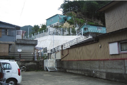
Fig. 3. Evacuation sites.
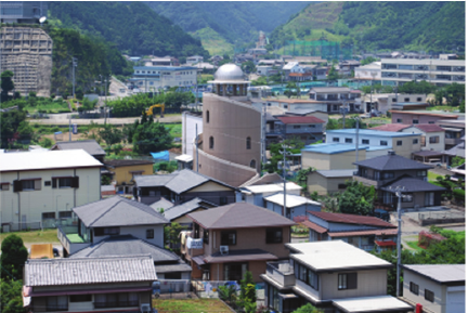
Fig. 4. Nishiki Tower.
2.2. Tsunami Evacuation Scheme in Nishiki District
Based on the experience of repeated earthquakes and tsunami disasters, Taiki-cho developed its own tsunami evacuation scheme. In 1980, the Kisei-cho authorities designated December 7, the day the 1944 Tonankai Earthquake had occurred, as “Kisei-cho Disaster Prevention Day” to commemorate the occurrence of the earthquake. In 1989, the “45th Anniversary of the Tonankai Earthquake” was published by compiling the stories of disaster victims. From 1994 to 1995, the town authorities visited the areas affected by the 1993 Hokkaido Nansei Offshore Earthquake and the 1995 Great Hanshin-Awaji Earthquake and, as an administrative agency, launched a full-scale disaster prevention measure. The following three chief characteristics were identified 25.
The first is to improve evacuation facilities. The basic literacy of tsunami DRR is to promptly evacuate vertically to higher ground. There are 30 designated emergency evacuation sites in Nishiki for tsunamis (Fig. 3). Twenty-seven of these sites are located on higher ground outside the expected tsunami inundation area in the event of a maximum-class Nankai Trough earthquake. The remaining three sites are the Nishiki Tower (Fig. 4), the second Nishiki Tower, and the former Nishiki Junior High School shelter, all of which are located within the expected 10-meter flood zone. The evacuation space in Nishiki Tower is located approximately 12 m above the ground, and the meeting room in the second Nishiki Tower is located approximately 15 m above the ground. Regarding the former Nishiki Junior High School, an evacuation space is provided on the roof of a three-story school building. Thus, all evacuation shelters in Nishiki district are located higher than the maximum tsunami inundation depth.
For emergency evacuation, considering not only the tsunami inundation depth, but also the arrival speed of the tsunami is essential. The maximum depth of tsunami inundation that would allow free evacuation is estimated to be 30 cm; however, in coastal communities in the central Nishiki district, the time from earthquake occurrence to 30 cm inundation is estimated to be at most 20 minutes 24, which is generally insufficient to evacuate from a tsunami. However, because the 30 evacuation sites are located within a 5-minute walking distance for all residents in Nishiki (most of them on the slope immediately behind the housing), there is sufficient time to safely reach the evacuation sites, if evacuation activities are initiated as soon as the quake ceases.
The second measure is related to fostering a local disaster culture. Although old stone monuments related to the Tonankai and Ansei earthquakes have been handed down at the temple, town authorities have installed new monuments throughout the district, as well as signboards indicating the elevation of the location of these monuments. On December 7, “Disaster Prevention Day,” the town authorities, in cooperation with the fire brigade, hold a tsunami evacuation drill for residents. In addition, public lectures, workshops, observations, and excursions for residents have been conducted with the support of Mie Prefecture and the local university, and some results have been incorporated into the town’s disaster prevention plan. These are intended not only to visualize the collective memory of past experiences and pass them on to the next generation in the community, but also to localize the scientific knowledge of earthquakes and tsunamis.
Finally, and most uniquely, town authorities have worked independently of the central government and the Meteorological Agency to create their own local tsunami warning system. Under this system, even before the earthquake information and tsunami early warnings are issued by the Japan Meteorological Agency, when a town hall employee feels a strong 20-second horizontal tremor, he or she presses an alarm button located at the town branch office, and an evacuation instruction is issued through the outdoor warning device network. As it includes decisions based on lay knowledge 26, it has limitations, such as not being able to respond to tsunami earthquakes or distant earthquakes; however, the town authorities have taken the stance of respecting such on-site decisions.
The tsunami evacuation scheme in the Nishiki district was proven to be effective after the 7.4-magnitude earthquake off the southeast coast of the Kii Peninsula that occurred late at night on September 5, 2004. Although 42 cities, towns, and villages in three prefectures were subject to tsunami warnings, only 12 cities, towns, and villages issued evacuation advisories, and the evacuation rate for residents averaged only 4.6% in the three prefectures. However, the Taiki-cho authorities issued an evacuation advisory before the tsunami warning by the Japan Meteorological Agency, and the evacuation rate of residents in Nishiki district reached 79%.
According to our survey on evacuation behavior during earthquakes 27, approximately 72% of the respondents evacuated all or part of their families, and approximately 95% believed that a tsunami may follow the shaking. Nearly half of those who evacuated cited “self-determination” as the reason for their evacuation, and more than a quarter were prompted by warnings from the town. Although no major tsunami hit at that time, 93% of the respondents did not regret evacuation, and approximately 85% believed that it was inevitable to be slightly off mark for the safety of the residents and that this approach should be continued. Thus, many residents acquired the ability to evacuate based on their own judgment and formed a relationship of trust in the town authorities’ efforts. It can be said that the grassroots disaster preparedness of a small municipality in an earthquake-prone area was demonstrated.
2.3. Changes in Hazard Countermeasures After the Great East Japan Earthquake
Over the past two decades, particularly in the period following the 2011 Great East Japan Earthquake, the DRR in Nishiki has undergone significant changes. The focus of tsunami countermeasures in Nishiki has been on “evacuation” from tsunami, and emphasis has been placed on community-based disaster risk reduction mechanisms within a participatory framework. Thus, structural damage deterrence measures were secondary. At the time the tsunami evacuation scheme was devised, Nishiki district had only a 3.5-meter-high seawall, which was installed after Typhoon Vera in 1959. However, after the Great East Japan Earthquake, constructing a large seawall encircling Nishiki district was planned. The existing levee at the mouth of the bay was raised to 9.1 meters above sea level, a new 8-meter-high seawall was built behind the fishing port, and an estuary weir was planned to prepare for tsunami run-up to the river. In addition, the construction of an offshore seawall has begun to partition the waters behind the bay and is currently awaiting natural subsidence of the seafloor foundation.
Although these do not imply a shift away from the existing tsunami evacuation scheme, they suggest, at least in part, that town authorities have shifted the emphasis of their DRR measures to the physical expansion of disaster-mitigation facilities. The town’s disaster prevention and safety division explains that it is in response to the aging population and new central government guidelines for tsunami DRR, which were established after the Great East Japan Earthquake. However, undeniably, Taiki-cho as a remoter rural municipality struggling with financial difficulties used “disaster reduction” to attract subsidies from newly established projects such as the National Resilience Project.
However, there was a sense of crisis in the town authorities that the previous approach would not work. Regarding this situation, for example, a senior official at the town hall stated, “During evacuation drills, the elderly gather at the bottom of the stairs, but are unable to climb up to the evacuation site” (deputy mayor), and “It is impossible for residents in their 80s to evacuate other residents in their 80s.” (chairman of the Town Council). The participation rate of district residents in evacuation drills has declined from 70%–80% approximately 20 years ago to approximately 30% today. As stated by the former head of the Disaster Prevention and Safety Division, “The issue of evacuation for the elderly was not on the agenda 20 years ago,” and the recent demographic changes common to rural communities in remote areas, such as the aging of the population, have forced town authorities to reconsider their DRR measures.
The population of Nishiki district peaked at more than 4,300 in 1950 and has continued to decline annually, reaching one-third of its peak in 2020, with the five-year rate of decline increasing to approximately 10% since 1985. However, the number of households remained at approximately 1,000 from the 1950s to approximately 2000, but began to decline sharply after 2005, falling to approximately 750 households in 2020. Thus, the population decline could be attributed to the outflow of young people, with a concomitant reduction in household size and natural growth rate; however, the problem in recent years has been the rapid decline in the number of households. The percentage of elderly people rose sharply from 24% in 1995 to 55% in 2020 (the percentage of people aged 75 years and over rose from 10% to 32% during the same period), and the percentage of single-person households and households comprising only elderly couples rose from less than 10% in 1995 to more than 25% in 2020 (combined, they accounted for more than half of all households) (Fig. 5).
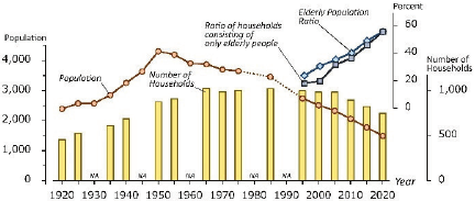
Note: The elderly population ratio and the ratio of households comprising only elderly population is not available before 1990. The number of households is not available for several years before 1990. Source: Population Census of Japan.
Fig. 5. Changing population structure of Nishiki district.
According to the interviews we conducted, knowledge and awareness of tsunami DRR among older adults remained at a high level. However, physical decline with age is undeniable and the disaster culture shared and inherited by families and communities is at risk.
Table 1. Brief chronology of Nishiki district.

Under these circumstances, in 2023, the town mayor proposed a plan to relocate elderly people who have difficulty evacuating to higher ground in advance. This project aims to construct eight town-owned rental houses for elderly households in need of support (20 to 30 houses in the end) on town-owned land 20 m above sea level (the original swamp land was reclaimed with construction debris from the highway), and provide a home-care and meal delivery services, a simple store, and a community bus stop, to be operational in 2028. Further, the project includes the relocation of the Senior Citizens Welfare Center, currently located in a low-lying area. According to the deputy mayor, this project aims to propose a model for livable living for the elderly and promote the integration of DRR and welfare for the elderly.
As described above, existing tsunami countermeasures in Nishiki district, which focus on emergency evacuation, have been forced to undergo revision owing to the weakening of the foundation of the community that supports them, and their effectiveness is now in doubt. Although the town authorities are aiming to improve the current situation by combining the physical expansion of structural facilities for DRR with the welfare of the elderly, the type of impact that this project will have on Nishiki district remains unclear. This is discussed in detail in the following sections.
3. Social Changes in Fishing Village and Transformation of Community-Based DRR
3.1. Social Structure and DRR in Fishing Village
As described in Section 2, tsunami evacuation schemes in Nishiki were developed from the 1990s onward. This subsection examines community-based DRR in the area prior to that period by tracing longer-term changes in DRR practices in relation to local livelihoods (Table 1).
The Kumano-nada coastline, where Nishiki is located, is an excellent natural port. Although the area is prone to tsunamis and flooding, it has been inhabited since ancient times owing to its abundance of natural blessings.
Nishiki has one of the best fishing grounds in Japan, recording the highest catch of yellowtail during the 1930s. Despite extensive damage caused by the Tonankai earthquake, the residents of Nishiki rebuilt their lives and resumed fishing three months later 28. After World War II, power boats became widespread and Nishiki’s fishing industry developed further. At its peak during the 1970s and the 1980s, the total value of fish landed at the Nishiki fishing port reached 3 billion yen, creating a boom in the Nishiki area (Fig. 6). There were more than a dozen bars, four public bathhouses, two movie theaters, and a billiard hall in the area.
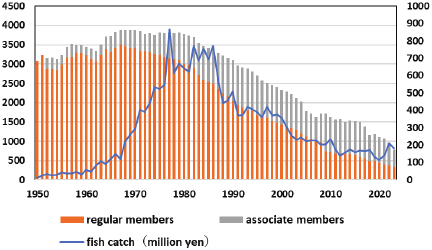
Note: Based on documents provided by Nishiki Fisheries Cooperative Association.
Fig. 6. Trends in fisheries in Nishiki.
Regarding social structure, Nishiki is an indigenous fishing village and a homogeneous area with overlapping local and blood ties. The history book of Nishiki-cho mentions this fact, stating that “almost everyone in the village is related to each other by blood” 22. The livelihoods of the people were almost exclusively fisheries, and the location was separated from the greater metropolitan area in terms of transportation conditions. Nishiki used to be a highly self-sufficient area.
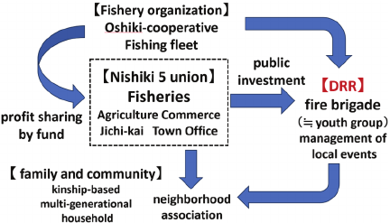
Fig. 7. Community organizations and DRR in Nishiki (high economic growth period).
In Nishiki, the fishing cooperative, agricultural cooperative, chamber of commerce and industry, Jichi-kai (community organization), and town office were regarded as the core organizations of the district, and these “Nishiki 5 union” formed a federation that managed the entire district (Fig. 7). Of these, fishing cooperatives were the most influential. At the peak of the fishing industry, 80% of the Nishiki residents were engaged in the fishing industry. Therefore, the head of the fishermen’s cooperative held the top position among the five organizations and was said to be “more powerful than the town mayor.” In addition, the proceeds from the fishing industry were used to fund public activities within the community. Nishiki’s mainstay fishery, the fixed-net fishery, was operated with funds invested by cooperative members (Oshiki-kumiai), and the proceeds from yellowtail catches were returned to the cooperative members in the form of shares (dividends). Among them, Jichi-kai was the major shareholder in Oshiki-kumiai. Jichi-kai in Nishiki was a community organization independent of the unit neighborhood association (Chonai-kai) and used dividends from the Oshiki-kumiai as funds for local events (festivals, etc.) and public works (simple water supply, etc.) in Nishiki. As described above, in the past, livelihoods and community organizations were integrated into Nishiki, and residents took the initiative in community management by using their financial resources. Thus, the role played by the town office was limited, and its status among “Nishiki 5 union” was relatively low.
DRR activities were also embedded in this organizational structure for livelihood and community activities. The leading DRR organization in Nishiki was the fire brigade. Nishiki’s fire brigade, with 400 members across three divisions, was regarded as one of the best in the prefecture. In addition to the regular fire brigade, fire brigade alumni organized a separate unit to support the fire brigade. Moreover, a separate relief group tasked with water rescue activities was organized, forming a broad social basis for community-based DRR. Young fishermen engaged in fire brigade activities were under the leadership of the fishing organization as members of the fishing boat fleet (haul net fishing) and had a strong sense of solidarity. Young fishermen were taken for granted as members of the fire brigade, and it was normal for them to concurrently engage in youth group activities (Seinen-dan). Thus, firemen were also in charge of local festivals and other events. Residents were able to ask young fishermen for help not only in the event of a disaster, but also if they had any problems. In this sense, DRR was integrated into livelihood and community organizations.
Self-help, a prerequisite for mutual aid, was also much more stable than it is today. As the fishing industry was hereditary and many households were multigenerational and lived together, measures for elderly people in need of assistance in the event of a disaster were not regarded as an issue requiring consideration.
Before the 1990s, awareness of the risk of a Nankai Trough earthquake was not as high in Nishiki, and evacuation drills were not conducted as they are today. However, according to interviews with residents, “things like today’s voluntary disaster management activities were carried out naturally in everyday life.”
3.2. Exogenous Development and Decline of Fishing Industry
However, Nishiki’s fishing industry gradually began to decline. As previously mentioned, Nishiki’s fish landings peaked during the 1970s and the 1980s, however, from the 1960s, the number of regular union members began to decline, and the percentage of associate members increased (Fig. 6). During the 1980s, the number of members of fishing cooperatives began to decline, a trend that continues today. The decline in the number of fishermen was not necessarily owing to low income. Certainly, the fishing industry, which deals with nature, has some income instability, but in Nishiki, during the high-growth period, fishermen’s income was reportedly much higher than that of ordinary civil servants. One factor that has had a significant impact on the fluctuations of the fishing industry in Nishiki is a series of exogenous developments, such as the plan to construct a nuclear power plant.
During the period of high economic growth in Mie Prefecture, the regional disparity in terms of population and financial capacity between industrial cities in the north and fishing villages in the south became pronounced. Against this backdrop, in 1963, the then-governor of Mie Prefecture proposed a plan to invite a nuclear power plant to Ashihama, located on the border between Kisei-cho (present-day Taiki-cho) and Nanto-cho (present-day Minami Ise-cho). In 1965, the Kumano-nada Coastal Development Plan was proposed to promote road and port development in the southern part of the prefecture, using compensation funds from the nuclear power plant project. The Ashihama nuclear power plant construction plan underwent complications and was finally withdrawn in 2000. Over the past 37 years, fishing villages along Kumano-nada have been at the mercy of development projects.
Kisei-cho’s decision to accept construction of the Ashihama nuclear power plant for financial reasons had the following effects on the fishing industry. First, fishing operations were restricted because of a site survey conducted by the Chubu Electric Power Company. Second, the large compensation payments guaranteed reasonable income even if the fishermen did not fish, which reduced their motivation to fish. Moreover, the town became increasingly dependent on compensation and donations from nuclear power plants for the development of roads, public facilities, and other infrastructures. Third, measures promoting the fishing industry were delayed. Owing to concerns about the impact of treated water (thermal wastewater) on fishing grounds after a nuclear power plant was constructed, the town authorities used compensation funds to formulate a plan to promote aquaculture, which led to a shift to yellowtail farming. However, yellowtail aquaculture was booming nationwide, resulting in overproduction and reduced fish prices. Further, fisheries cooperatives became increasingly dependent on compensation, and because they were left in a state of limbo, not knowing when the nuclear power plant would come online, they failed to take proactive measures to promote the fishing industry. Nishiki’s fishing industry fell behind other municipalities, such as Nanto-cho, which opposed nuclear power plant construction and actively promoted the development of the fishing industry. This long-term stagnation has caused the younger generation to leave the fishing industry. As Nishiki’s employment structure specializes in the fishing industry and alternative employment opportunities are scarce, many young people who left the fishing industry migrated out of the town 29,30,31.
Even after the Ashihama nuclear power plant plan was withdrawn in 2000 after many complexities, Nishiki’s fishing industry continued to be under the influence of external development. Around the time that the nuclear power plant plan was canceled, a plan to build the Chubu International Airport emerged. The Chubu International Airport is an offshore airport that requires large amounts of reclaimed materials for construction. However, in the highly urbanized Aichi Prefecture, land-based sources of sediment supply were already limited. Dredging of marine sediment near the proposed airport site was also difficult because of environmental regulations; therefore, the aim was to procure reclamation materials exclusively from mountain soil in the hills of the southern Mie Prefecture 32. Kisei-cho was the largest supply area, and mountain soil from the hills was transported by a conveyor belt to the coast and then by ships to the planned airport site. This large-scale public works project created jobs in the construction industry in Kisei-cho, and brought large amounts of compensation to the fishing cooperative. However, the decline in the fishing industry and outflow of young people were further accelerated by the development project.
Furthermore, global warming has had a tremendous impact on the fishing industry in recent years, and fish landings have drastically decreased since 2018 owing to the significant meandering of the Kuroshio Current. To cope with such crises in the fishing industry, tourism fishing (running fishing boats and private accommodations) has been attempted in recent years. However, this is far from reviving the critical situation of the fishing industry.
3.3. Transformation of DRR
With the decline in the fishing industry and population outflow, there have been significant changes in the DRR in Nishiki, leading to a decline in community-based DRR.
First, the Nishiki 5 union was dissolved. A drastic decline in the number of fishery cooperative members and fish catches resulted in the loss of the financial support for the independent activities of the Nishiki 5 union. Consequently, the five unions lost their character as federated entities, and Nishiki’s cohesion and self-management weakened. Jichi-kai, which used to be the major shareholder of the Oshiki-kumiai and controlled the management of the district, also lost its role and was reorganized into a mere festival organization.
As the population declined and the number of small elderly households increased, the community’s neighborhood association activities also stagnated. As it is difficult to sustain community activities within the existing population, town authorities are now committed to using outside human resources such as Local Vitalization Cooperators and immigration measures. Although the inflow of migrants has brought a new impetus to residents’ lives, they are few and have not transformed population trends. The decline in population has been accompanied by the withdrawal of public and commercial services, which has significantly reduced the convenience of living in the area. The closure of Nishiki Junior High School in 2009 and Nishiki Elementary School in 2025 marked the deprivation of community functions.
Furthermore, these structural changes in Nishiki have led to changes in DRR mechanisms. As the number of fishermen declined, the fire brigade shrank from 400 members at its peak to approximately 60. The youth organization (Seinen-dan), which had once been inseparable from the fire brigade, was also disbanded. Firefighters’ alumni associations and relief groups were also dissolved. Consequently, the social basis of DRR activities in Nishiki has weakened. Taiki-cho authorities are currently promoting the development of voluntary disaster management organizations; however, Nishiki district is the only one in the town where such organizations have not yet been established. This is partly because Nishiki used to be able to cope with disasters without such organizations, but also because the unit neighborhood association (Chonai-kai), which is supposed to be the foundation for the voluntary disaster management organization, is not being operated properly owing to the excessive aging of the population.
The decline in community activities has been replaced by the growing presence of town offices (administrative management), which since the 1990s have taken the lead in disaster management and specialized in Nankai Trough earthquake countermeasures. As discussed in Section 2, various advanced efforts have been made to implement government-led countermeasures against hazards. However, DRR in Nishiki today is no longer related to local livelihoods and community organizations. Regarding financial resources, the construction of tsunami evacuation facilities and seawalls was made possible by reliance on compensation for external development and government subsidies (Fig. 8). Therefore, from a long-term perspective, the development of earthquake DRR countermeasures in Nishiki since the 1990s can be interpreted as a disconnection and transformation rather than the development of conventional community-based DRR.

Fig. 8. Current community organizations and DRR in Nishiki.
4. Pre-Disaster Relocation Plan for Elderly to Upland
4.1. Policy Integration of DRR and Welfare
As mentioned in Section 2, currently, in Nishiki, a plan has emerged to relocate the elderly who need assistance to higher ground in advance. Taiki-cho procured a project site on a hill at an elevation of approximately 20 m in the northern inland area of Nishiki district (red square in Fig. 2). The plan is to lay water pipes in this location and develop public housing for the elderly. The initial development will provide housing for 5–10 households, with expansion planned as needed.
Although the Nishiki tsunami evacuation scheme established in the 1990s was effective even in the event of the maximum-class Nankai Trough earthquake, it assumed that “healthy people who can evacuate quickly on their own” could do so. Under the current situation, where this premise has collapsed, it is reasonable to relocate elderly people who have difficulty evacuating to higher ground in advance as a tsunami evacuation countermeasure. In addition, as previously mentioned, the plan for relocating to higher ground includes welfare goals for the elderly and new community development. The plan is a model for the Act on Development of Areas Resilient to Tsunami Disasters in that it considers not only DRR but also community development.
Prior to the formulation of the upland relocation plan, town authorities conducted a face-to-face survey of all 517 residents aged 75 years and older, comprising 408 households residing within the town. The number of residents who responded to the survey was 296 from 213 households, with response rates of 57.3% and 51.2%, respectively. According to the results of this survey, 50.7% of the respondents expressed a desire to use elevated facilities. Town authorities assessed that the plan was largely supported and aimed to commence the construction of the project. One concern in the implementation of this project plan is securing financial resources. Relocation is expected to cost approximately 1 billion yen; however, the town’s finances are strained, with less than 20% of its own funds (in FY2023). Therefore, the feasibility of the project depends on national subsidies.
Although the aims of the town authorities for this plan are described above, the perceptions of elderly residents and other inhabitants of Nishiki regarding relocation to higher ground are examined through a detailed analysis of survey results and interviews.
4.2. Determinants of Relocation Orientation to Higher Ground
The simple tabulation results of the survey are summarized as follows. Almost all households are small elderly households with detached owner-occupied houses. 60.6% of the households are single-person households, and 39.0% are two-person households. Only 8.5% of the houses were earthquake-proofed. Of the respondents, 54.5% “have neighbors to help them when a disaster strikes,” indicating that nearly half of the respondents do not have neighbors to help them. However, 81.7% of the respondents “can evacuate to an evacuation shelter by themselves,” and the percentage of those who use welfare services is relatively low at 32.0%. Although more than 80% of the respondents said they could evacuate on their own, the aforementioned 50.7% desiring to use high-ground housing may reflect an uncertainty about their physical condition in the near future.
The plan aimed to move elderly individuals who have difficulty evacuating to higher ground in order to save lives. However, survey results revealed that those who have difficulty evacuating do not necessarily want to relocate to higher ground. Contrarily, such elderly people tend to be more reluctant to move (Fig. 9).
Analysis by district demonstrated that the percentage of respondents wishing to relocate to higher ground was not necessarily higher in areas where evacuation was difficult (Fig. 10).
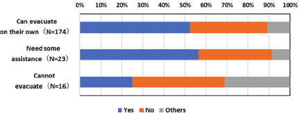
Fig. 9. “Do you wish to move to the uplands?” (by degree of difficulty in evacuating).
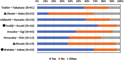
Note: • indicates a high relocation preference rate, and ▲ indicates a low relocation preference rate. See Fig. 2 for the location of each district.
Fig. 10. “Do you wish to move to uplands?” (by district).
Indeed, Tsukiji–Suzaki, which has the highest relocation preference rate, is a reclaimed area on fragile ground and is the district with the highest risk in terms of tsunami inundation depth and arrival time. However, Wakaba–Sakae, which has a similarly high relocation preference rate, is furthest from the sea, and Wakaba, which is particularly hilly, is the district with the lowest tsunami risk. The high relocation preference rate in Wakaba–Sakae may not be because of the difficulty of evacuation, but rather may be related to the proximity of the relocation site to the current residence, making it easier to relocate (see Fig. 2 for the locations of each district).
Considering the districts with the lowest desired relocation rates, Okuide–Naka, which certainly has the lowest desired relocation rate, is located on a higher ground and has the lowest need for relocation. However, Hinode, which has the next lowest usage preference, is in the highest-risk area for tsunamis, like Tsukiji–Suzaki. According to interviews conducted in the area, this may be related to the fact that Hinode is a relatively recently developed neighborhood and housing is still new.
Second, related to the first point, residents’ intentions regarding relocation to a higher ground are not simply divided into two groups: those who wish to relocate and those who do not. The open-ended responses (84) confirmed the desire to relocate under various conditions. The most common condition was “it depends on the location.” The fact that the relocation site was decided top-down by the town authorities without consultation with the residents may have caused some dissension. In addition, although the planned relocation site was outside the tsunami inundation zone, the ground was fragile because it was created by reclaiming swamp land. Therefore, the residents did not have a satisfactory impression of the planned site, and during interviews, they expressed concerns that liquefaction would occur in the event of an earthquake. The next most common comment was “I would like to (relocate) if I could be with my neighbors.” This reflects the Nishiki’s indigenous nature. There were also opinions such as, “I can live here now, but if I become disabled (I would like to move).”
Reasons for not wanting to relocate were also diverse. Some of them were based on tsunami safety, such as “because I live on higher ground” or “because the evacuation site is closer,” but there were many other reasons as well. For example, “I don’t want to leave my familiar home.” This opinion is particularly prevalent among those who are very old and may be related to the previously noted tendency (Fig. 9) of those who have difficulty evacuating on their own to be less likely to wish to relocate. The purpose of relocating to higher ground is to save the lives of elderly people who have difficulty evacuating by themselves. However, this suggests a dilemma in that the elderly people are more attached to their current homes. Other reasons provided were “because I will be moving to a family member’s house elsewhere” and “because I cannot dispose of my house,” which are unrelated to the difficulties of the evacuation. As described above, while relocation to higher ground is the rationale for tsunami evacuation, the rationale for residents’ choices of residential location is much more diverse.
4.3. Disaster-Resilient Community Planning and its Challenges
The plan to relocate to higher ground in the Nishiki area was intended not only for tsunami evacuation but also for the welfare of the elderly and community development. Certainly, the plan to consolidate housing for the elderly in need of assistance at the relocated site and arrange simple stores and welfare facilities may contribute to improving the convenience of daily life. However, the following problems can be identified in this plan.
First, even if the elderly wish to relocate, it is not economically viable for them. As aforementioned, the elderly in Nishiki live in detached owner-occupied houses; however, if they wish to relocate, they must dispose of their owner-occupied houses. This is because, in addition to rent and relocation expenses for public housing, they will be forced to pay maintenance costs and property taxes if they retain their owner-occupied homes. However, they cannot expect their children to inherit their houses, and it is difficult for them to sell them. Regarding public subsidies, the Act on Development of Areas Resilient to Tsunami Disasters does not provide financial measures for purchasing private residential land for relocation. We noted earlier that some elderly respondents expressed the view that the reason they did not wish to relocate was because they could not dispose of their owner-occupied houses, a constraint arising from the above circumstances. Similar views were confirmed through field interviews.
-
“Economic problems are the primary issue. It is not that they do not want to move into upland housing, but the reality is that they cannot. It is difficult to decide whether to spend money on a tsunami that may or may not happen.” (from interview with fishery cooperative staff)
-
“During the Great East Japan Earthquake, the government bought residential land in tsunami-inundated areas. However, it is impossible for them to buy in advance. Then, I think it would be better if my house were also washed away by the tsunami.” (from interview with elderly resident)
Second, upland relocation will proceed based on individual choice. Thus, non-elderly and elderly residents who do not wish to relocate will remain in coastal areas. Consequently, unlike the Disaster Prevention and Group Relocation Promotion Project, which aims to relocate communities, this project may lead to community dissolution. As discussed, the elderly have a psychological resistance to such situations. Although the plan to relocate to higher ground may contribute to the formation of a welfare community at the relocation site, it may also divide the Nishiki district between residents living on higher ground and those remaining in coastal areas, weakening community cohesion.
Third, the plan to relocate the elderly to higher ground is not pre-disaster recovery planning. Pre-disaster recovery planning involves the advance preparation of post-disaster recovery projects 2. For these reasons, in Nishiki, private houses remain on the beach, even after the plan to relocate to higher ground has been implemented. In the event of a maximum-class Nankai Trough earthquake, even if emergency evacuation is successful, the tsunami will wash away houses along the coast, making pre-disaster recovery planning for coastal areas an important challenge. However, at present, this point remains untouched, and even land for temporary housing is yet to be secured. The residents also expressed concerns regarding this issue.
-
“The town authorities should consider in advance, measures for shelters after a tsunami, not relocation. They should prepare places for people who survive after the disaster. If a disaster occurs, people have no choice but to relocate to the community. However, it is impossible to relocate collectively at this point.” (from interview with elderly resident)
Although land-use constraints are an important reason for the delay in pre-disaster recovery planning, a more fundamental reason is the difficulty in presenting a medium- to long-term vision for the town. If industry and job opportunities, which are prerequisites for the next generation of residents to continue living in an area, are not guaranteed, DRR countermeasures may lose their meaning.
-
“Even if we were able to evacuate from a tsunami, we would have no place to return to. We do not have a place to work. This is the fundamental problem this town faces.” (from interview with elderly resident)
5. DRR and Sustainability of Depopulated Fishing Village
The chief findings from the analysis are as follows.
(1) The tsunami evacuation measures promoted in Nishiki in the 1990s were effective from a seismological perspective in terms of dealing with the assumption of a maximum-class earthquake (tsunami inundation depth and arrival speed). This proactive response was achieved based on the social proximity between the town office and residents, which is a characteristic of small municipalities, and the experience of past earthquakes. The Nishiki case suggests that the effectiveness of DRR is determined not only by scientific disaster literacy, but also by local sociocultural factors, and that small fishing village communities can be advanced and flexible regarding tsunami disaster prevention.
(2) Historically, however, there has been a disconnect between the DRR in Nishiki since the 1990s and before. In the past, DRR was integrated into the livelihood system in communities centered on fishing; however, today, such linkages have been lost, and disaster prevention has been transformed into countermeasures led by town authorities focused only on hazard (tsunami) mitigation and evacuation. The fundamental challenge to disaster preparedness in Nishiki today is not so much in DRR itself, but rather in the fact that DRR is no longer linked to community sustainability.
(3) A series of exogenous developments has had a major impact on the transformation of the DRR in Nishiki. The nuclear power plant construction plan and airport construction project, backed by national land development, have disrupted the livelihood system of Nishiki, which specializes in fishing, resulting in an outflow of young people and a weakening of the social basis of the DRR. This suggests the importance of viewing DRR not only as a hazard measure, but also in relation to long-term trends in regional development.
(4) The policy currently being promoted in Nishiki to relocate the elderly to higher ground in advance is a reasonable tsunami countermeasure and an advanced example of the Act on Development of Areas Resilient to Tsunami Disasters, which aims to create a disaster-resilient welfare community. However, the policy objective of saving the lives of the elderly who have difficulty evacuating on their own does not necessarily coincide with their motivation to move to higher ground. The community-building aspect of DRR measures also has limitations, and the perspective of industrial revitalization is left unexplored, leaving sustainability as an issue that remains unresolved.
Based on this discussion, we propose several policy recommendations. From a short-term perspective, the primary challenges are building a consensus and the participation of residents regarding the ongoing plan to relocate to higher ground. Although the town authorities rush to commence construction with the justification that it has received the support of approximately half of the elderly people surveyed, as aforementioned, the opinions of the elderly regarding moving to higher ground are diverse and cannot necessarily be evaluated in terms of a dichotomy between those in favor and those opposed. There are many other matters to consider, such as social ties with family members and relatives who have left the area, alternative sites for relocation, and the impact of relocation to a higher ground on living conditions and DRR in coastal areas. We should not only decide whether to relocate but also derive more diverse options based on these considerations.
From a long-term perspective, considering more extensive land-use restructuring is necessary. Realistically, it is difficult to regenerate ties between livelihoods and DRR, as in the past in Nishiki, where the industrial base has been lost. Aside from coping with disaster prevention, it is unclear whether Nishiki will exist in the next 20–30 years. Population decline will increase not only in Nishiki but also in Japan as a whole. Simultaneously, the country will be forced to cope with the effects of disasters and climate change. If we rely on these predictions, it is difficult to assume that conventional DRR measures based on individual municipalities will remain effective in the future. The Act on Development of Areas Resilient to Tsunami Disasters states that municipalities are responsible for planning the development of tsunami disaster prevention areas. However, there are clear limitations to this. We will inevitably be forced to consider regional sustainability and DRR from a broader perspective that extends beyond the scale of individual municipalities. How land is used in Nishiki also needs to be considered on a regional scale, with an eye to the division of roles and linkages between urban areas and rural villages. In this context, land uses such as green infrastructure and buffer zones, which are not necessarily residential, are important options 33.
Serious depopulation and aging are common challenges facing many fishing villages in Japan, and the preemptive relocation of elderly residents to higher ground is expected to be introduced in more areas. In this sense, the above proposals are considered to hold a certain degree of validity not only for the Nishiki district, but also for depopulated Japanese fishing villages in general. Although each fishing village possesses diverse local characteristics and faces many specific short-term issues that need to be addressed, it is time to seriously consider such drastic measures.
Acknowledgments
This study was supported by the Ministry of Education, Culture, Sports, Science and Technology of Japan, under its “The Third Earthquake and Volcano Hazards Observation and Research” program. We are also grateful to the residents and administrative staff of Taiki-cho who cooperated with the field research, and especially to Mr. Nakaseo Tsugio for his dedicated coordination efforts.
- [1] O. Ikuta, “Disaster prevention law,” Shinzansha Publishing Co., Ltd., 2013 (in Japanese).
- [2] S. Sasaki, “Latest disaster prevention and recovery legislation,” Dai-Ichi Hoki Co., Ltd., 2017 (in Japanese).
- [3] D. Shiozaki and Y. Hashimoto, “System development for tsunami evacuation drill using ICT and tsunami inundation simulation data,” J. Disaster Res., Vol.19, No.1, pp. 72-80, 2024. https://doi.org/10.20965/jdr.2024.p0072
- [4] K. Yamori, “Open science for fostering seismologic science literacy,” J. Disaster Res., Vol.19, No.1, pp. 139-146, 2024. https://doi.org/10.20965/jdr.2024.p0139
- [5] H. Nakamichi, “Open-door events of the Sakurajima volcano observatory,” J. Disaster Res., Vol.19, No.1, pp. 147-153, 2024. https://doi.org/10.20965/jdr.2024.p0147
- [6] M. Takubo, M. Sugiura, R. Ishibashi, N. Miura, and A. Tanabe-Ishibashi, “How disaster prevention videos contribute to tsunami evacuation: Subjective motivation and risk-sensitive attitude in a simulation experiment,” J. Disaster Res., Vol.19, No.1, pp. 94-104, 2024. https://doi.org/10.20965/jdr.2024.p0094
- [7] M. Sawada and T. Sato, “The possibility of wide area evacuation in the event of natural disasters: A survey in Amagasaki City, Hyogo Prefecture,” J. Disaster Res., Vol.19, No.1, pp. 105-112, 2024. https://doi.org/10.20965/jdr.2024.p0105
- [8] W. Kurata, “Disaster resilient and welfare community,” Minerva Shobo Co., Ltd., 1999 (in Japanese).
- [9] E. L. Quarantelli, “Disasters theory and research,” SAGE Publications Ltd., 1978.
- [10] A. H. Barton, “Communities in disaster,” Doubleday and Company Inc., 1969.
- [11] K. Hewitt (Ed.), “Interpretations of calamity,” Allen and Unwin, 1983.
- [12] A. Oliver-Smith, “The martyred city,” University of New Mexico Press, 1986.
- [13] B. Wisner, P. Blaikie, T. Cannon, and I. Davis, “At risk: Natural hazards, people’s vulnerability and disasters,” Routledge, 2003.
- [14] A. Oliver-Smith, “Theorizing vulnerability in a globalized world: A political ecological perspective,” A. Oliver-Smith and S. M. Hoffmann (Eds.), “Catastrophe and culture: The anthropology of disaster,” School of American Research Press, 2002.
- [15] I. Burton, R. W. Kates, and G. F. White, “The environment as hazard (2nd edition),” Guilford Press, 1993.
- [16] S. Yoshihara, “Land problems in an era of declining population,” Chuokoron-Shinsha Inc., 2017 (in Japanese).
- [17] K. Igarashi, “Who owns the land?,” Iwanami Shoten, 2022 (in Japanese).
- [18] H. Masuda, “Disappearance of countryside,” Iwanami Shoten, 2014 (in Japanese).
- [19] Headquarters for Earthquake Research Promotion, “Long-term assessment of Nankai Trough seismic activity (Version 2),” 2013 (in Japanese).
- [20] S. Nakata, “Research on the history of disasters in fishing villages in Mie Prefecture, part 2: Ansei no Tsunami 2,” Umi to Ningen, Vol.19, pp. 1-127, 1991 (in Japanese).
- [21] S. Sekiguchi, “Big tsunami in Kumano: Tonankai earthquake just before the defeat of the war,” 1990 (in Japanese).
- [22] H. Sakaguchi, “Nishiki-cho journal: Re-issued,” Nishiki-cho Tourist Association, 1955 (in Japanese).
- [23] S. Nakata, “Research on the history of disasters in fishing villages in Mie Prefecture, part 1: Hoei no Tsunami,” Umi to Ningen, Vol.16, pp. 1-54, 1989 (in Japanese).
- [24] Mie Prefecture, “Mie Prefecture Earthquake Damage Assumption Survey in 2013,” 2014 (in Japanese).
- [25] T. Nakaseko, F. Kimata, S. Tanaka, and M. Takahashi, “Tsunami warning evacuation system in Nishiki of central Japan,” Proc. of Int. Conf. on Tsunami Warning, 2008.
- [26] F. Kimata and T. Nakaseko, “Onsite tsunami warning system in Nishiki, central Japan: Seismological background,” Proc. of Int. Conf. on Tsunami Warning, 2008.
- [27] M. Takahashi, S. Tanaka, F. Kimata, T. Nakaseko, and Suhirman, “Proposing the community-based tsunami warning system,” Proc. of Int. Conf. on Tsunami Warning, 2008.
- [28] Kisei-cho, “History of Kisei-cho: Record edition,” 2001 (in Japanese).
- [29] H. Kitamura, “Ashihama nuclear power plant now: 20 years history of Ashihama Nuclear Power Plant,” Gendai Shokan Co., Ltd., 1986 (in Japanese).
- [30] H. Kitamura, “The town that stopped the nuclear power plant: 37-year battle for the Ashihama Nuclear Power Plant in Mie,” Gendai Shokan Co., Ltd., 2011 (in Japanese).
- [31] Asahi Shimbun Tsu Branch, “The sea! 30 Years of Ashihama Nuclear Power Plant,” Fubaisha, Inc., 1994 (in Japanese).
- [32] T. Sato, “Development and application of pneumatic flow mixing method to reclamation for offshore airport,” Technical Note of the Port and Airport Research Institute, No.1076, pp. 1-81, 2004 (in Japanese).
- [33] Green Infrastructure Study Group (Ed.), “Green infrastructure: Implementation version,” Nikkei Business Publications, Inc., 2020 (in Japanese).
This article is published under a Creative Commons Attribution-NoDerivatives 4.0 Internationa License.