Paper:
Creating Space for Disaster Lore Transmission Based on the Disaster Digital Archive: The Case of the 2014 Kamishiro Fault Earthquake Disaster Archive
Kotoe Uchiyama†, Daisuke Hirouchi, Satoko Nasu, Yasushi Sakakibara, and Iwao Kurasawa
Shinshu University
6-ro Nishi Nagano, Nagano 380-8544, Japan
†Corresponding author

This study uses the example of the 2014 Kamishiro Fault Earthquake Disaster Archive, which collects digital materials on the 2014 Kamishiro Fault Earthquake in Nagano Prefecture and makes them accessible on the Internet. It examines what constitutes an effective disaster digital archive in order to transmit disaster records and lessons learned within the local community, as well as the archive’s future outlook. The study further discusses the creation of a space for disaster lore transmission through the construction and utilization of a disaster digital archive. Since the 2014 Kamishiro Fault Earthquake is regarded as a local disaster even within Japan, both in terms of its limited geographical impact and its level of social recognition, the significance of preserving these disaster records lies primarily in their utilization by residents of the affected areas. The key to preserving such local disasters records lies in the self-directed use of disaster digital archives by local communities, particularly for learning-related purposes, such as school education, lifelong learning, and tourism. This study highlights the importance of interactive use between the digital archive (digital space) and off-site bases (real space), as well as the need for personnel training and the establishment of appropriate mechanisms to support disaster lore transmission. It proposes this approach as an effective means of disaster lore transmission, through which the experiences of past disasters are recorded and passed on to future generations.
2014 Kamishiro Fault Earthquake Disaster Archive
1. Introduction
The Nagano Prefecture Kamishiro Fault Earthquake (hereafter, Kamishiro Fault Earthquake) occurred on November 22, 2014, with its epicenter in Hakuba Village, Kita Azumi County, Nagano Prefecture. For local residents to learn the lessons gained from this earthquake as issues relevant to their own lives and make full use of these lessons in future disaster-mitigation efforts, it is important to examine disaster lore transmission, that is, how the disaster experience is handed down to later generations.
Disaster lore has generally been transmitted in various ways, including the publication of photo collections or documented records, storytelling by those who have experienced disasters, the construction of stone monuments or lore transmission facilities, and the preservation of disaster remains. These measures can be considered as efforts to “imprint” past disaster situations, lessons learned, and future disaster risks through artifacts and spaces or through individual and collective memories.
However, disaster-mitigation effects cannot be expected if local residents do not learn the lessons, even if disaster remains have been physically preserved as artifacts. Furthermore, it is meaningless to preserve photos of disasters in documented records unless they are used in some manner. Thus, it is necessary for local residents to actively use the records of disasters or memories of them and lessons learned from them and to construct a mechanism to apply them to disaster mitigation so that they can be transmitted more effectively.
Since the 2011 Great East Japan Earthquake and Tsunami Disaster, many digital archives that electronically store disaster-related resources and make them accessible to the public have been constructed 1. By centrally managing vast amounts of materials as digital data and allowing anyone to access information, they have great utility. However, a considerable number of these have not gone beyond the mere storage of electronic data in voluminous documents, and their purposes remain unclear. Consequently, there were some cases in which websites were terminated after a decade without being effectively utilized 2.
Such problems highlight the necessity for the sustainable maintenance and management of digital disaster archives and the need to review the objective of archive construction with fresh eyes. In other words, it is important to clearly set forth the issues of “who the archive is for,” “what is being preserved,” and “how the archive can be utilized effectively” from the planning stage.
The authors—as part of a joint project with the municipalities of Hakuba and Otari Villages in Nagano Prefecture—have constructed the 2014 Kamishiro Fault Earthquake Disaster Archive(1) (Kamishiro DA) since 2017, to preserve the records and memories of this earthquake for future generations and to enable their use in disaster mitigation. They have also undertaken efforts to effectively utilize it by linking it with community activities. In this paper, we describe the creation of a space for disaster lore transmission and discuss the significance and issues of the archive identified by this undertaking.
2. Background of This Study
2.1. Issues on the Transmission of Disaster Lore
Following the 2011 Great East Japan Earthquake, “Seven Principles for the Reconstruction Framework” were proposed. These principles included recording the disaster for posterity and encouraging its analysis by numerous scholars to draw lessons that would be shared with the world and passed down to future generations.(2) These principles have generated significant interest in preserving disaster-related materials. Furthermore, the Basic Act on Disaster Management was amended in June 2012, stipulating residents’ responsibility to hand down lessons learned from past disasters to improve disaster-mitigation awareness. It also made it mandatory for national, prefectural, and municipal governments and their disaster management personnel to endeavor to provide disaster prevention education. In this regard, there have been practical efforts to reassess disaster-related lessons or wisdom handed down in local communities and to transmit them through disaster prevention education and community-building activities 3.
How do disaster lessons become part of an individual’s knowledge or disaster-mitigation awareness? According to a case study in Indonesia of the 2004 Indian Ocean earthquake and tsunami, tsunami experience was not transmitted over generations at the individual level; therefore, disaster experience alone cannot result in the formation of a disaster culture. Meanwhile, in tsunami-prone areas in Japan, the experience of dealing with a tsunami has become embedded in local societies as collective memories in the form of stone monuments and oral traditions 4.
For instance, in the Sanriku region, which is a tsunami-prone area, there are stone monuments marking the positions that past tsunamis reached; some residents were able to escape and survive the tsunami following the 2011 Great East Japan Earthquake by observing the lessons provided by these stone monuments 5. These examples are discussed in the context of “disaster lore” or “disaster culture,” in which surveys have been conducted to document disaster events and people’s responses to them.
On the other hand, prior to the 2011 Great East Japan Earthquake, opportunities to transmit tsunami-related lore from parents to offspring had dwindled in Kamaishi, Iwate Prefecture, and a lack of knowledge regarding evacuation in the event of tsunamis was found among these children 6. There is also the issue of whether the significance of stone monuments in disaster-affected areas is understood by local residents 7.
These studies discussed the disaster-related lore discuss in the context of disaster culture. They emphasize the importance of preserving this culture for future generations by local residents being cognizant of the lore handed down in the community and continuing to transmit it from generation to generation. Yet, a challenge remains: under present conditions, it is difficult for lessons learned from past disasters to be handed down even in disaster-prone areas.
2.2. Current Status and Issues of Disaster Digital Archives
Disaster digital archives(3) have been established as a means of disaster-related lore transmission in many locations throughout Japan. Previous methods for preserving records consisted primarily of the publication of written records or photo collections, which were collected and kept by libraries; however, these materials have limited dissemination power, are not easily handled, and are limited in their ability to be reproduced.
Owing to the advent of the Internet and the widespread use of smartphones and other digital devices in recent years, many disaster digital archives that collect and store records in the form of digital data have been established since the Great East Japan Earthquake. Over forty such archives can be found in Japan. Naturally, many have focused on the records of the Great East Japan Earthquake.
We reviewed the features of these digital archives by identifying their advantages and challenges. The advantages are that documents are prevented from damage or deterioration, there is the possibility of multifaceted usage (use as instructional material or in lifelong learning), access to resources is not limited spatially or temporally, and resources can be easily searched through database functions. Because it is possible to centrally manage a vast amount of information that can be accessed by anyone, an archive can be highly useful.
However, there are issues with both utilization and continuity. A survey on the utilization of archives related to the Great East Japan Earthquake indicated that many digital disaster archives were insufficiently utilized 9.
Disaster digital archives can be broadly divided into three categories: 1) databases specializing in the searching or browsing of data, 2) archives that show examples of use in addition to the database, and 3) archives intended to be utilized by specific local communities whose members actively engage in the collection and use of data. Examples of 1) include “Great East Japan Earthquake Disaster Archive Miyagi” 10 and the “National Diet Library Great East Japan Earthquake Archive” 11. Many are hosted by local governments, and their main objective is to preserve documents. For instance, the homepage of the “Koriyama Earthquake Archive” 12 consists of a search screen, which is not easily navigated unless one knows what to look for. Meanwhile, the “Otsuchi Town Earthquake Archive” 13 allows one to search under categories, but it is not sufficiently user-friendly.
With regard to volcanic disasters, the Japan Volcanological Data Network, a major research institute dedicated to volcanological research, collected, organized, and made public photographic materials related to the Mount Unzen eruptions that occurred between 1990 and 1995 14. Their objective was to make a photographic database accessible for use in volcanological research.
Examples of 2) include “Iwate Earthquake and Tsunami Archive—Hope” 15, “Michinoku-Shinrokuden” 16, and “Digital Archives of Kumamoto Disasters” 17. While these archives suggest ways for use by introducing a few model cases, they have not been actively used by local communities. There are almost no examples of 3), with the notable exception of “Disaster Archive Gifu,” which represents a progressive case of an archive created, operated, and utilized by the local communities themselves, where the local residents upload disaster-related information 18. As these examples suggest, there are almost no archives at present that are actively utilized by local communities, rather than just presenting information on past disasters.
The creation of digital disaster archives is a predominantly Japanese phenomenon, although there are several examples of such archives in other countries. Examples include the “Aceh Tsunami Archive” 19, which documents the 2004 Sumatra earthquake in Indonesia, and the “CEISMIC Canterbury Earthquakes Digital Archive” 20, which focuses on the seismic activity in New Zealand’s Canterbury region since 2010. In the case of the “Aceh Tsunami Archive,” although archive developers have held workshops and taken other steps 21, it cannot be said that the archive is being actively utilized by the local community. A similar collaborative approach is evident in the New Zealand example, which encompasses a project with diverse content providers, including individual citizens, government agencies, local organizations, and major media companies. Nonetheless, both archives are databases that primarily focus on searching and viewing data 22.
The effective utilization of an archive is directly related to its continuity after its creation. In fact, many archives have been closed down because their usage or objectives were uncertain, and their effectiveness remained unevaluated as they were not used 23. Thus, the issues of utilization and continuity are related to one another.
2.3. Objective of This Study
In view of the present situation, it is necessary to propose a way to transmit disaster lore that can contribute to heightening the disaster-mitigation capabilities of local communities in a manner that resolves the present issues. In order to do so, it is essential to clearly identify the objectives for using of past disaster records and the target audience—“for whose purpose,” “what should be preserved,” and “how it should be made use of”—make it easy to edit and utilize information, and build a mechanism through which local residents can effectively utilize the offered information for their own initiatives. This means that to effectively transmit disaster lore, it is important to not only create a digital disaster archive, as in the case of stone monuments, but also to nurture human resources that can transmit disaster lore by utilizing the archive, and thus formulate a new approach to lore transmission.
To address these issues, we constructed a disaster digital archive (Kamishiro DA) to transmit the memories and lessens of the Kamishiro Fault Earthquake in collaboration with the municipalities of Hakuba and Otari Villages. Furthermore, we constructed a mechanism to make use of this archive in disaster prevention education in schools and lifelong learning programs for local residents, and created opportunities to enable local residents to use the archive on a continual basis. Thus, we present an approach to disaster digital archives in which the disaster lore can be sustainably transmitted. This undertaking, which combines the training of personnel charged with disaster lore transmission and the creation of a mechanism for their sustained activities, is defined as the “creation of a space for disaster lore transmission.” Using this notion, with the Kamishiro DA as a case study, we discuss the creation of a space for disaster lore transmission, which involves the creation of a mechanism for the learning-centered usage of the archive.
3. Targeted Areas and Outline of Nagano Prefecture’s Kamishiro Fault Earthquake
Hakuba Village, Kita Azumi County, Nagano Prefecture, is located in the northwestern section of Nagano Prefecture, extending 16.8 km in the north-south direction and 15.7 km in the east-west direction; it has a population of 8,575, with 3,709 households (2020 National Census 24). Otari Village is located in the northwesternmost section of Nagano Prefecture, extending 20.5 km north–south and 14 km east–west. 88% of the village’s area is covered by forests, and its population is 2,647, with 1,145 households (2020 National Census 24).
The Kamishiro Fault Earthquake was a reverse fault earthquake that occurred around 22:08 on November 22, 2014, with its epicenter at Hakuba, and recorded a seismic intensity of Mj 6.7 (Fig. 1) 25. Since a surface earthquake fault extending approximately 9 km from Hokujo Shioshima to Horinouchi in Hakuba was confirmed, the earthquake was considered to have occurred because of the activities of the Kamishiro Fault in the Itoigawa-Shizuoka Tectonic Line 26,27,28. This earthquake recorded a maximum seismic intensity of lower 6 (Japan Meteorological Agency Seismic Intensity Scale) in Otari Village, Ogawa Village, and Nagano City, causing eight serious injuries and 38 minor injuries, and damages consisting of 81 completely destroyed, 175 partially destroyed, and 2,146 partially destroyed houses in Nagano Prefecture 29.
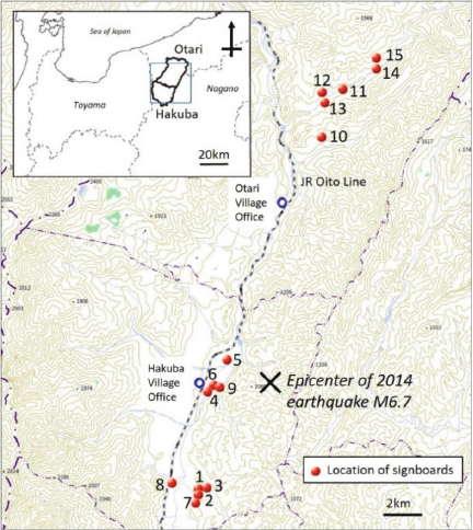
Fig. 1. Target area. This map is based on the GSI Maps published by the Geospatial Information Authority of Japan.
Table 1. Damage status in Hakuba and Otari Villages caused by the Kamishiro Fault Earthquake (based on 29).

The damage that occurred in the two villages is presented in Table 1. Many people were injured and many houses were damaged in the Kamishiro District (Horinouchi and Mikkaichiba wards), Hakuba Village, and the Nakatsuchi District of Otari Village. However, there were no fatalities owing to the prompt actions of residents to ensure one another’s safety and the rapid rescue activities, an outcome that has been called the “Miracle at Hakuba.” Kamishiro DA was targeted at Hakuba and Otari Villages in Kita-Azumi County, Nagano Prefecture, which suffered the most severe damage from the earthquake (Fig. 1).
4. Outline of Kamishiro DA
4.1. Background Leading to Construction
Although the Kamishiro Fault Earthquake resulted in severe damage to buildings and the local economy in the affected areas, it was a local disaster with a limited geographical impact. To improve the local disaster-mitigation capacity using the records of the local disaster, it was necessary to construct a digital disaster archive that recorded local information closely tied to residents at the neighborhood level, and to create a mechanism to transmit disaster lore using this archive.
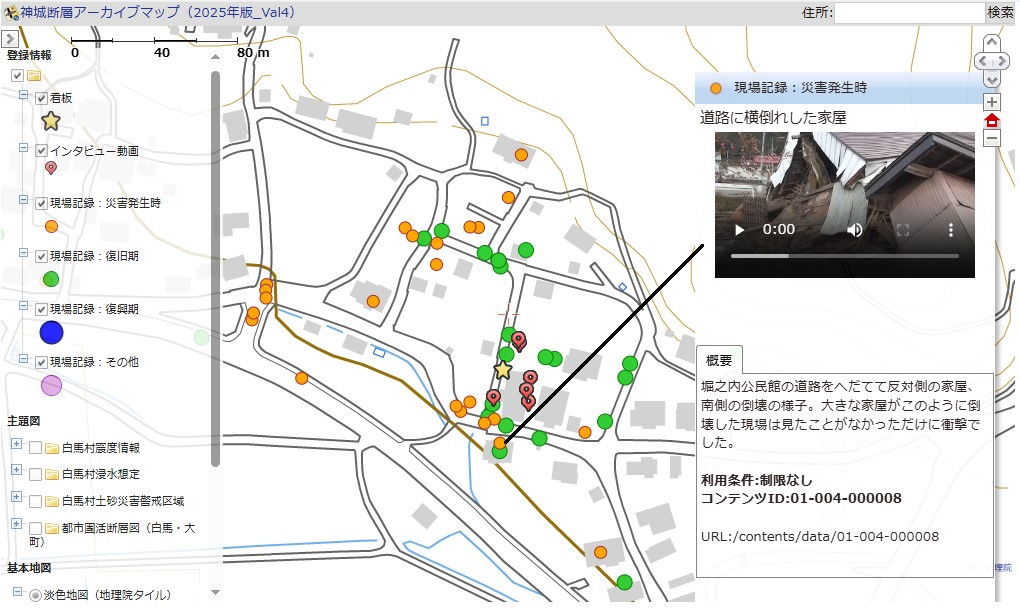
Hakuba Village, Otari Village, and Shinshu University have been collaborating on this research since 2017. To enhance regional disaster resilience by preserving the lessons learned from the Kamishiro Fault Earthquake without allowing them to fade, they began to digitize records and memories of the earthquake. This will ensure that the lessons are safe and can be used in the future. The Kamishiro DA—released in 2018—tags disaster material with positional information and timestamps, so that the user can see “what occurred, when, and where” on the map. Specifically, we geotagged the collected photos, documents, and interviews with those affected by the disaster so that they could be viewed on a map based on the Web-GIS (geographical information system) to enable spatial searches. Moreover, disasters can give rise to various problems as time passes from their occurrence to recovery and reconstruction. The changing situations of the area and experiences of affected people—evacuation, life at evacuation centers, rebuilding of lives, and reconstruction activities—are recorded in photos and interview videos, organized according the time of disaster occurrence, recovery period, and reconstruction period. Then they are layered onto the map, so that the archive allows the user to understand the changes that occurred in the area after the disaster struck (Fig. 2).
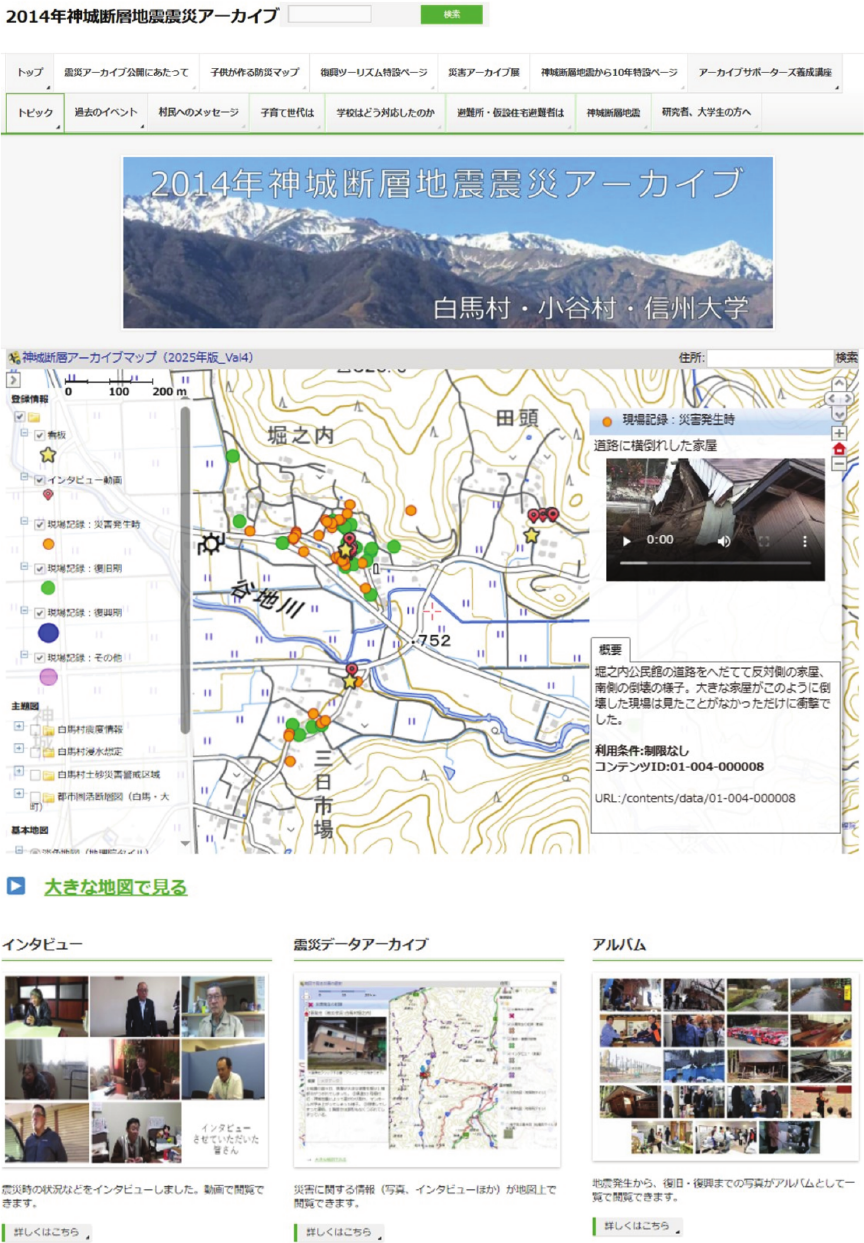
Fig. 2. 2014 Kamishiro Fault Earthquake Disaster Archive.
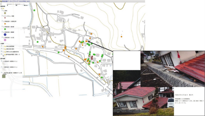
Fig. 3. Examples of archive screens.
4.2. Collection of Contents
The contents collected in the Kamishiro DA consist of photos of damage captured immediately after the earthquake, accounts of experiences of the disaster, and changing local scenes and human activities accompanying recovery and reconstruction. Photographs were provided by the municipal governments of Hakuba and Otari as well as individuals and organizations. These were mainly collected in digital form, and photo prints were scanned to obtain digital data. The contents vary widely, consisting of damage to houses and roads in the villages immediately following the earthquake, scenes of volunteer work at evacuation centers and elsewhere, volunteer fire brigades activities, recovery and reconstruction work, temporary housing, reconstruction process, and commemorative events.
Interviews were conducted by the authors, focusing on disaster victims and recorded on video. The interviews followed a semi-structured, timeline-based format, covering their experiences prior to and leading up to the earthquake and their activities during the recovery and reconstruction periods. With reference to other disaster digital archives, we selected residents affected by the earthquake, village municipal officers charged with disaster management, school personnel, mothers with children, and volunteers as interviewees. The interviewees were sent interview questions beforehand, and the actual interviews took approximately two hours each. Common questions included the location of the interviewee when the earthquake occurred, the actions taken then, the damage to their house and surroundings, specific hardships, and the period when life returned to normal. Additional questions were asked depending on the attributes of the interviewee.
4.3. Organizing the Contents
The photographs and videos were tagged with positional information, given explanatory captions, and compiled into PDF documents (Fig. 3). Positional information was checked on a map by the person who provided the photo or video, and the latitude and longitude of the captured location were identified and recorded by the authors. The interviews were edited into chapters by content, each lasting 5–10 minutes, and attaching Japanese-language subtitles, so that each interview consisted of five to seven chapters.
For each item, the authors registered the positional information (latitude and longitude), time and date of capture, source, privacy setting, title and description, search tags, and storage location of the original to create the metadata. Furthermore, the items were linked via icons representing different phases, consisting of the time of earthquake occurrence, recovery period, and reconstruction period, to register them on the Web-GIS.
The copyrights of the contents were transferred to the site administrator after an agreement was obtained from their providers. Data providers signed consent forms as part of the approval procedures. Moreover, the faces of the individuals and vehicle numbers were masked to prevent their identification. The agreement also included whether secondary usage was allowed, which made it possible for them to be used as materials in disaster prevention learning and local disaster-mitigation activities.
4.4. Outline of the Kamishiro DA Website
The Kamishiro DA website became accessible on November 21, 2018, four years after the earthquake. The website was constructed using WordPress and “e-com map,”(4) to achieve a responsive design. To facilitate searching, the main page configurations consisted of the “map archive,” “album,” “interviews,” “reconstruction tourism,” and “archive supporter training course.”
The map archive provides links to “interview footage,” “signboards (locations of installed signboards),” and photographs/videos arranged in layers of “on-site records (at time of earthquake),” “onsite records (recovery period),” “onsite records (reconstruction period),” and “onsite records (other).” This allows the user to search for the necessary information spatially and temporally using icons. The background employs the electronic national map (light-colored base map and standard map) provided by the Geospatial Information Authority of Japan, which can also be switched to satellite imaging. In addition, the seismic intensity map, inundation risk areas, landslide warning areas in Hakuba, and active faults in the urban areas can be overlaid. Searches using keyword entries are also possible.
The album collects photographs for which positional information is unknown and scenes from events, grouped into categories such as housing and facilities, school damage, activities of volunteer fire brigades and volunteers, and reconstruction housing, which were further grouped into disaster phases (time periods). All data are managed through a cloud server.
5. Specific Application Cases of Kamishiro DA
In this study, we undertook the creation of a space for disaster lore transmission centered on learning, using the archive in three types of learning contexts and nurturing personnel to carry out these activities to ensure the continued use of the archive. Specifically, this approach consists of the placement of signboards that link the Kamishiro DA with disaster remains, and three learning activities that make use of these signboards: 1) school-based learning, 2) learning in the local community through lifelong learning, and 3) learning as part of reconstruction tourism.
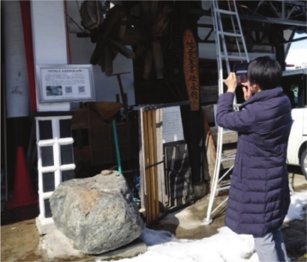
Fig. 4. A tourist scanning a QR code on a signboard using a smartphone.
5.1. Installation of Signboards that Link Disaster Remains with the Archive and Map Production
We installed explanatory signboards with QR codes at 15 locations (as of 2023) along the surface earthquake fault and at disaster remains in Hakuba and Otari Villages 30. By scanning the QR codes on the signboards using smartphones, visitors can browse the archive and learn what occurred at the time of the earthquake and during the recovery period (Fig. 4). In other words, we created a system in which one can understand the disaster and the subsequent reconstruction efforts while viewing photos taken at the sites after the earthquake.
In addition, we created a Reconstruction Tourism Map that shows the locations of the signboards, is distributed locally, and is accessible on the website. By creating a system through which one can go back and forth between the Kamishiro DA (digital space) and signboards (real space), representing the past and present, anyone can learn at any time; thus, we created a space for disaster lore transmission centered on the three learning contexts in which the archive is used.
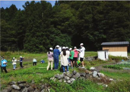
Fig. 5. Elementary school students visiting the surface earthquake fault for the fieldwork.
Table 2. Activities of Archive Supporter Training Course.

5.2. School Learning: Disaster Prevention Learning in Elementary and Junior-High Schools
Since 2019, the authors have conducted classes in which the Kamishiro DA and earthquake remains have been used at elementary and junior-high schools in Hakuba and Otari Villages 31. The learning process for this disaster prevention course consists of classroom lectures, fieldwork, and group presentations. The learning objectives are to understand the formation of the active fault and topography that led to the disaster, as well as the resulting damage in the area, through archival research and fieldwork using signboards. In addition, the course aims to develop students’ self-reliant thinking about what is needed and what actions should be taken to prepare for disasters and save lives, and to nurture an attitude that will allow students to act in times of emergency.
In elementary schools, we used sixth-grade science and fifth- and sixth-grade integrated learning classes, where the students learned about the Kamishiro Fault Earthquake. After using the Kamishiro DA to learn about the extensive damage caused by the earthquake, its underlying mechanism, and the surface fault, the students learned from observations in the Shioshima District, where the earthquake fault has been preserved; from the fault outcrop in the Warabidaira District, about earthquakes and crustal movements; and about the relationship between the area’s natural and social environment and disasters (Fig. 5). The results of the fieldwork were summarized by the students and presented as posters in the archive display room and at a report session commemorating the 7th anniversary of the earthquake.
At the junior-high school, disaster prevention learning utilizing the archive was undertaken mainly by a group that studies “Nature in Hakuba” during the Period for Integrated Studies. Participants 1) learned about the damage status at the time of the earthquake, 2) compared the situation then and now at actual sites, and 3) interviewed earthquake victims. After using the Kamishiro DA to learn about the damage at the time of the earthquake and interviewing municipal officials and local residents, they were encouraged to think on their own about what was necessary to prepare for disasters and what they could actually undertake. The learning results were presented to local residents at a report session commemorating the 7th anniversary of the earthquake and were remotely transmitted to students at Hakuba Minami Elementary School.
5.3. Learning in Local Communities: Training of Archive Supporters Who Can Serve as Storytellers
In collaboration with the Hakuba Community Center lecture “Training Course for Piedmont Guides,” the authors have, since 2021, conducted an Archive Supporter Training Course. This training program, in which the Piedmont Guides will also become Archive Supporters, aims to nurture local residents who can serve as storytellers and hand down the lessons learned from the Kamishiro Fault Earthquake.
The “Piedmont Guide” is a lifelong learning program initiated by the Hakuba Village Board of Education in 2020 to produce guides who can conduct tours to educate Hakuba residents on its culture, history, folklore, and nature. The Archive Supporter Training Course offers lessons necessary to become a guide for the Kamishiro Fault Earthquake, in addition to the Piedmont Guide content; it is a system to nurture personnel who can orally transmit experiences of and facts about the Kamishiro Fault Earthquake. By continuing this program, we hope that the lore related to earthquake damage and lessons learned can be passed on, ultimately raising disaster-mitigation awareness in local communities.
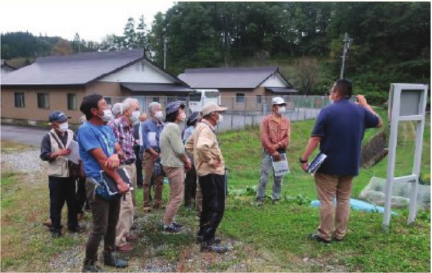
Fig. 6. Fieldwork for archive supporters.
The activities of the Archive Supporter Training Course are presented in Table 2. Through the learning process of classroom lectures, fieldwork, and presentations, the program trains personnel who can act as guides for damaged locations and active faults of the Kamishiro Fault Earthquake while making use of the signboards and reconstruction tourism map. In the first year, the participants visited the surface earthquake fault, acquired knowledge of tectonic landforms and active faults, and learned about the area’s damage and recovery and reconstruction episodes using the Kamishiro DA (Fig. 6). Based on this knowledge, they planned guided tour courses to visit signboard locations and presented the results at the 7th anniversary report session. In the second year, they participated in fieldwork by visiting signboards in Otari Village to further their knowledge of the Kamishiro Fault Earthquake. In the third year, they visited Minami Aso Village in Kumamoto Prefecture, which suffered damage during the 2016 Kumamoto Earthquake, observed the remains of the Kumamoto Earthquake, and participated in a social gathering with local guides to acquire explanatory techniques and other relevant knowledge. The group also drew up a chronological table of Hakuba Village disasters and deepened their knowledge of past disasters. Beginning in 2022, archive supporters participated in disaster prevention learning programs at elementary schools, where they supported the fieldwork of students. The three-year program established a guidance framework as a whole.
5.4. Learning Through Reconstruction Tourism
In areas of the Tohoku region that were extensively damaged in the 2011 Great East Japan Earthquake and Tsunami Disaster, “reconstruction tourism” is being promoted, through which tourists can participate in experiential learning programs or storytelling tours at earthquake disaster lore transmission facilities or disaster remains with the goal of raising disaster prevention awareness 32. The aims of reconstruction tourism are to educate visitors on the lessons learned from the Great East Japan Earthquake, attract more visitors, and stimulate the local economy. Similar programs are also being conducted in areas that suffered from the 2016 Kumamoto Earthquake 33.
While issues have been pointed out regarding the use of the term “reconstruction tourism,”(5) in this study, we define “reconstruction tourism” as an undertaking whereby people can learn by visiting remains of the Kamishiro Fault Earthquake, focusing on the topography—such as the surface earthquake fault, the present state of the villages after recovery and reconstruction efforts—and the activities of people. In this section, we describe two concrete examples of reconstruction tourism: 1) the disaster prevention disaster-mitigation event in collaboration with a local firm and 2) guided activities by archive supporters.
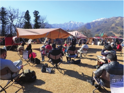
Fig. 7. Disaster prevention event cohosted with a local firm.
5.4.1. Disaster Prevention Event in Collaboration with Local Firm
The Hakuba Village Municipality, Shinshu University, and the Snow Peak LAND STATION HAKUBA, owned by Snow Peak Inc., collaborated to host three disaster prevention events. The events, each consisting of seminars and fieldwork lasting from half a day to a day, were centered on the premises of Snow Peak LAND STATION HAKUBA (Fig. 7). The events consisted of a presentation on how to use outdoor gears in the event of a disaster and fieldwork in which the participants toured the signboards while linking up with the archive. Participants took a rental bicycle tour, riding electric bicycles to visit signboards in the village using the reconstruction tourism map. They accessed images and information that showed the situation at the time of the earthquake on the Kamishiro DA using QR codes, enabling them to learn by going back and forth between “now” and “then.” In FY2022, the participants were taken on a bus tour to visit the Horinouchi District, which had suffered extensive damage, where they heard about rescue activities following the earthquake and the victims’ experience of evacuating with children. The response of participants included views such as “I learned that items necessary at times of disaster and outdoor gear have a very high compatibility” and “By visiting reconstructed sites in the affected areas and hearing the residents’ experiences, I realized the importance of one’s connection with the local community.”
In this manner, we created new learning opportunities for residents and tourists through reconstruction tourism, in which participants toured disaster remains using the signboards and the Kamishiro DA. Thus, we were able to provide a space to effectively learn about disasters by considering disaster remains, such as surface earthquake faults, as local resources and by making use of the archive. By creating opportunities for participants to look back at the earthquake disaster as an extension of their leisure time, even when they are not primarily focused on disaster prevention or disasters, this undertaking can raise disaster-mitigation awareness.
5.4.2. Guide Activities of Archive Supporters
Archive supporters have been carrying out reconstruction tourism guided activities in response to a visitor requests since FY2022. Since September 2022, they have guided visitors from Nagano City, Ueda City, and Itoigawa City in Niigata Prefecture, and Kurashiki City in Okayama Prefecture. The archive supporters conduct guided tours while using the Kamishiro DA via signboards, centered on earthquake disaster remains and surface earthquake faults. Through these activities, guides can recognize the added value of their activities, promote self-reliant learning, expand learning among the residents and visitors, and disseminate information about the Kamishiro Fault Earthquake and the activities of the archive supporters. Furthermore, monetary compensation for guide activities is expected to secure the continuity of these activities in the future and lead to the self-supporting operation of the archive.
6. Discussion
6.1. Mechanism of Scale-Dependent Utilization
In the Sanriku coastal areas that were affected by the 2011 Great East Japan Earthquake and Tsunami, local governments have published documentary records funded by subsidies from the national government 36. Furthermore, local governments have produced disaster records and constructed remains and memorial facilities for large-scale disasters designated by the Japan Meteorological Agency, such as the 1991 Mount Unzen eruption, 1995 Southern Hyogo Prefecture Earthquake, 2004 Mid Niigata Prefecture Earthquake, 2016 Kumamoto Earthquake, and widely recognized disasters, to transmit events and lessons to future generations 37. In the case of major disasters like these, disaster archives whose objectives are to preserve records of the disasters or the lessons learned from them can be justified, since their effects extend not only to the disaster-hit areas but also to the entire country as well as internationally.
However, while the Kamishiro Fault Earthquake caused extensive damage to affected areas, it was a local disaster whose effects were geographically restricted. In disaster archives that record local disasters, it is important to “preserve records in a manner suitable to the area’s characteristics” 36 and “construct it depending on the scale and recognition level of the disaster and its objectives, taking sufficient account of the mechanism of operation and continuity” 38. Therefore, their significance lies in enabling the residents of affected areas to hand down their disaster experiences and actively retain lessons in local communities.
It is important to note that the population involved and the resources of the local government are limited in the case of local disasters, making it difficult to maintain and operate an archive.(6) However, reducing the operational costs does not necessarily ensure sustainability. It is crucial to develop skilled personnel to utilize the archives and ensure that those bearing costs recognize their significance. Therefore, the key to continuity lies in its use in school education or by local residents, and in establishing of an operational mechanism while keeping operational costs low. From the early construction stage, we emphasized disaster‑prevention learning and its promotion through residents’ self‑directed activities when developing the content and usage mechanisms.
6.2. Mutual Utilization of Digital Archive and Off-Site Locations
The creation of a digital archive is insufficient for preserving disaster records and their continual operation by making effective use of these records. As a strategy to achieve continuity, we constructed off-site bases that link with the archive by installing signboards at the sites of remains to create a learning mechanism linking the earthquake disaster with current locations.
Installed objects—such as stone monuments or disaster remains—and the surface earthquake fault can serve as landmarks for visitors and provide opportunities for on-site learning. However, the remains or explanatory signboards by themselves provide limited information and may fail to correctly convey their significance or value. By installing signboards that link with the digital archive, visitors can access a greater amount of information via the QR codes, such as explanations and photographs, and thus gain a greater understanding of the disaster. Simultaneously, the onsite visitor receives sensory information that is unobtainable from the documented materials. In this manner, in this study, we created the “three learning spaces”—school education, lifelong learning in communities, and reconstruction tourism—by making use of a mechanism that allows users to move between the website (digital space) and physical sites (real space). Such off-site bases tie together the respective advantages of digital and real space, mutually complementing one another, and enable the creation of an effective “space for disaster lore transmission.”
The effect of signboard installation can be assessed by the trend in website accesses via signboard QR codes (Fig. 8), where access counts display a net increase owing to access from signboards.(7) Furthermore, the total number of accesses has increased since the fall of 2022, when the guide activities of archive supporters began. This is likely due to the increased number of group visitors.
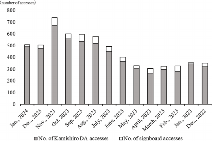
Fig. 8. Trend in number of signboard accesses and Kamishiro DA website accesses.
6.3. Creation of Space for Disaster Lore Transmission Utilizing Disaster Digital Archive
This study aimed to establish a local disaster digital archive by promoting community self-reliant use of the archive through school education, lifelong learning, and reconstruction tourism. The key aspects are the “creation of a mechanism” to encourage community use of the archive and “training personnel” to this end.
In this study, we used disaster prevention learning in school education as a channel for using the archive. This was intended to promote the archive’s long-term and continued use by allowing students to set up their own assignment topics for learning. Furthermore, the presentation of their findings extend the impact to parents and local residents, which will have the short-term effect of spreading awareness of the archive’s significance to the local community. In fact, the students’ responses included views such as “Since I came to know that an earthquake can be right around the corner, I try to be more watchful and become capable of protecting my own life” or “By actually visiting the sites, I developed a new awareness and actually felt the terror of earthquakes. I hope to remember what we learned and make good use of it”; none expressed a negative view.
Meanwhile, the learning through community disaster prevention programs and reconstruction tourism, which are both based on lifelong learning opportunities, is intended to instruct local residents and visitors on earthquake disasters using the disaster digital archive. By raising their interest in disasters and allowing them to orally transmit their experiences while learning, the lore can seep into the local communities and information can be disseminated widely. The archive supporter program aims to educate supporters about the Kamishiro Fault Earthquake so that they can then become involved in teaching other people. The training of supporters is intended to firmly establish a mechanism for disaster lore transmission and constitutes a concrete step toward greater archive utilization.
As discussed so far, we have created in this study a “space for disaster lore transmission” by building a mechanism to utilize the archive centered on learning. Creating a digital disaster archive to preserve and disseminate disaster lessons is insufficient. Only by establishing mechanisms to utilize the archive can personnel be trained to use it. When local residents, including children, learn about and internalize disaster risks in their immediate surroundings through archive use, viewing them as personal concerns, and preparing for future disasters by applying lessons from past events, this constitutes disaster transmission. Thus, the “three learning spaces” for archive utilization presented in this study are directly connected to “spaces for disaster transmission.” By firmly establishing learning activities, disseminating information through reconstruction tourism to local residents and beyond, and developing it into a sustainable mechanism, we hope to ensure the long-term continuity of the disaster digital archive and its autonomous operation.
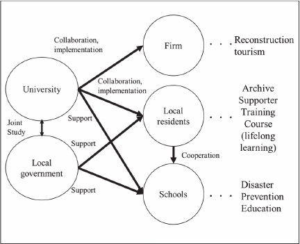
Fig. 9. Prevailing relationship among actors.
6.4. Issues and Future Outlook
In this study, we constructed the Kamishiro DA by setting objectives at the outset: “for the sake of local residents,” “preserve the local changes since the earthquake as spatial information,” and “create an archive that is used by the communities and that can be sustained in the future.” Although documented cases of the effective usage of disaster digital archives are few, we were able to create a “space for disaster lore transmission” that makes use of learning by linking actors related to the archive. This can be considered a proposal addressing how disaster experiences can be handed down to local communities.
However, there are some issues regarding the autonomous operation of archives by local residents and ensuring the continuity of activities. Kamishiro DA was developed and is operated through a collaborative research between universities and local governments (Fig. 9). Ten years after the Kamishiro Fault Earthquake, it will be necessary, to transition the system where it secure funds for archive supporters’ activities, for example by setting up a non-profit organization. In this process, it is necessary to recruit new member and solidify the foundations of future self-supporting operations, centered on those trained so far (Fig. 10).
One method would be to strengthen the collaboration between schools and archive supporters. Continuity can be secured by creating a structure in which archive supporters will support students’ fieldwork or disaster prevention learning while making use of the archive, establishing this mechanism as an essential learning space in schools’ disaster prevention and local area learning programs, and ensuring that there will be supporters in the future. While the present study has taken part in disaster prevention learning at schools using sixth-grade science and integrated learning periods, we hope to draw up curricula for various school years, such as the “local area exploration” in third-grade social studies and social studies and special activities periods in junior-high school, utilizing the archive, and to have the supporters continue carrying out these activities.
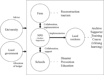
Fig. 10. Future relationship among actors.
It is also necessary to promote reconstruction tourism by making maximum use of the advantages of a web-based digital disaster archive to disseminate local information, spread know-how, and secure funding. An archive designed to preserve and transmit information about the Kamishiro Fault Earthquake, which was a local disaster, must be one in which local residents orally transmit their experiences of the earthquake and contribute to raising disaster prevention awareness among themselves by incorporating the lessons. With this understanding, the archive must be recognized as consisting of content that can be used by local residents to establish opportunities for broad-based learning in the community. While this study undertook maintenance and operation locally, it will become increasingly necessary to raise awareness of the Kamishiro DA in Hakuba Village, Otari Village, and beyond to disseminate relevant information on an even wider scale.
7. Conclusions
This study discusses the creation of a space for local disaster lore transmission through the construction and use of a disaster digital archive. The Kamishiro Fault Earthquake was a local disaster affecting a geographically restricted area. The significance of preserving disaster records in disaster-affected areas lies in their use by residents of the affected areas. Although there are several issues with disaster digital archives that record past disasters and make the experiences accessible, it is important to utilize disaster digital archives through activities centered on local residents’ learning, such as school education, lifelong learning, and reconstruction tourism, to preserve and hand down knowledge of local disasters.
The construction of a mechanism to utilize the archive centered on the learning of various actors, as proposed in this study, strengthens the ties between local activities and the archive, and ultimately results in the sustain ability of the archive. It is important to create a space for disaster lore transmission, link the digital archive (digital space) with off-site bases (real space), use interactively them, and promote the development of human resources and mechanisms to this end, which we propose as an effective means of disaster lore transmission. Therefore, continued efforts must be made by local residents to establish self-sustaining operations.
Acknowledgments
To carry out this study, we received invaluable help from the staff of Hakuba and Otari village governments, the residents of Hakuba and Otari Villages, teachers and students of Hakuba Kita Elementary School, Hakuba Minami Elementary School, Hakuba Junior-High School, and Otari Elementary School. We were also assisted in this study by Mr. Shunichi Yokoyama. The authors would like to express their deepest gratitude to the above-mentioned individuals. This study was jointly conducted by the municipalities of Otari and Hakuba Villages and Shinshu University, and received funding from the “Nagano ken Chiiki Hatsu Genki Zukuri Shien Kin,” the Kitano Foundation of Lifelong Integrated Education, and the Grants-in-Aid for Scientific Research (topic no. 23K00986). This study was also supported by the Ministry of Education, Culture, Sports, Science and Technology (MEXT) of Japan, under the Third Earthquake and Volcano Hazards Observation and Research Program (Earthquake and Volcano Hazard Reduction Research).
Footnotes
(1) https://kamishiro.shinshu-bousai.jp/ [Accessed August 31, 2025]
(2) https://www.cas.go.jp/jp/fukkou/english/index.html [Accessed November 22, 2025]
(3) Disaster archives are defined as “records of earthquakes and disasters that are collected, organized, preserved, made publicly available, and utilized by institutions, organizations, and individuals” and “materials that are widely digitized and made publicly available on the internet” 8. In this study, “disaster archives” refer to “those where institutions, organizations, and individuals collect, organize, preserve, publish, and utilize records of earthquakes and disasters.” Among these, “disaster digital archives” specifically refer to those that “broadly publish digitized materials on the Internet.”
(4) https://ecom-plat.jp/index.php?gid=10457 [Accessed November 22, 2025]
(5) The term “dark tourism” emerged in the 1990s to describe travel to sites of human tragedy, such as war and disaster sites. It has since become recognized as a form of tourism 34. In Japan, the term came into focus following the Great East Japan Earthquake. However, the term’s negative connotations have led to misunderstandings that deviate from its original academic meaning. This confusion has resulted in the emergence of new terms, such as “recovery tourism,” and has prompted calls to clarify its proper academic usage by reorganizing related research fields 35.
(6) Because of the initial setup costs required to launch the archive, Hakuba Village, Otari Village, and Shinshu University covered the expenses for the first three years of the research project. However, the ongoing maintenance costs are relatively low. This research utilizes cloud servers and outsources the maintenance and management framework. Adding data to the archive and updating its contents can be done at a low cost as part of the operating expenses. Generating funds from the archive’s practical use simplifies the operation, allowing for minimal information management and maintenance.
(7) Access counts from the signboard QR codes have been recorded since December 2022, when the data became available. Additionally, access counts from the signboard QR codes and access counts to the Kamishiro DA website are not duplicated.
- [1] A. Shibayama, M. Kitamura, S. P. Boret, and F. Imamura, “The state and visions of disaster archives as seen from the Great East Japan Earthquake,” J. of the Japan Society for Digital Archive, Vol.2, Issue 3, pp. 282-286, 2018 (in Japanese). https://doi.org/10.24506/jsda.2.3_282
- [2] M. Yamaguchi, “Symposium: A decade since the 2011 Great East Japan Earthquake: Expanding disaster digital archives in Japan: Roles of media in disaster education and passing down of disaster lessons,” The NHK Monthly Report on Broadcast Research, Vol.71, No.8, pp. 64-83, 2021.
- [3] R. Ishihara and N. Matsumura, “A study on the actual condition and the effects of disaster oral tradition in the coastal regions,” J. of Japan Society of Civil Engineers, Ser. D3 (Infrastructure Planning and Management), Vol.69, Issue 5, 2013 (in Japanese). https://doi.org/10.2208/jscejipm.69.I_101
- [4] S. Tanaka, “Immediately after: Damage and emergency response in tsunami disaster and reconstruction,” M. Takahashi, S. Tanaka, and F. Kimata (Eds.), “Aceh Following the 2004 Sumatra Earthquake,” Kokon-Shoin, pp. 99-104, 2014 (in Japanese).
- [5] Y. Hirakawa, S. Sato, K. Shirahata, and F. Imamura, “Consideration of relationship between tsunami monuments, tsunami inundation area, and human casualty—Case of the coastal area of Iwate Prefecture—,” J. of Japan Society of Civil Engineers, Ser. B2 (Coastal Engineering), Vol.72, Issue 2, pp. I_1621-I_1626, 2016 (in Japanese). https://doi.org/10.2208/kaigan.72.I_1621
- [6] M. Kanai, T. Katada, and H. Abe, “Study on tsunami disaster culture handed down from generation to generation in the coastal regions,” Infrastructure Planning Review, Vol.24, pp. 251-261, 2007 (in Japanese). https://doi.org/10.2208/journalip.24.251
- [7] F. Imamura, “The contemporary significance of disaster digital archives: Toward the creation of a new disaster prevention culture,” C. Suzuki (Ed.), “Digital Archive Basics 2 Using Disaster Records for the Future (Saigai Kiroku wo Mirai ni Ikasu),” Bensei-Sha, pp. 4-14, 2019 (in Japanese).
- [8] A. Shibayama, “The role of disaster archives, historical transition and current situation: Toward the creation of a new disaster prevention culture,” C. Suzuki (Ed.), “Digital Archive Basics 2 Using Disaster Records for the Future (Saigai Kiroku wo Mirai ni Ikasu),” Bensei-Sha, pp. 17-35, 2019 (in Japanese).
- [9] M. Ikeda and S. Sato, “Survey and analysis on the actual use of the Great East Japan Earthquake archives,” J. of Social Safety Science, Vol.37, pp. 219-226, 2020 (in Japanese). https://doi.org/10.11314/jisss.37.219
- [10] Miyagi Prefectural Government, “Great East Japan Earthquake Disaster Archive Miyagi,” 2015 (in Japanese). https://kioku.library.pref.miyagi.jp/ [Accessed August 31, 2025]
- [11] National Diet Library, “Hinagiku: National Diet Library Great East Japan Earthquake Archive,” 2013. https://kn.ndl.go.jp/#/ [Accessed August 31, 2025]
- [12] Koriyama City, “Koriyama Disaster Archive,” 2015 (in Japanese). http://jmapps.ne.jp/koriyama_shinsai_archive/ [Accessed August 31, 2025]
- [13] Otsuchi Town, “Tsumugi: Otsuchi Town Earthquake Archive,” 2017 (in Japanese). https://archive.town.otsuchi.iwate.jp/ [Accessed August 31, 2025]
- [14] Y. Kohno, H. Ueda, and S. Nakada, “Construction and provision of digital photographic archives by using the Japan Volcanological Data Network system: Application to the 1990–1995 Mount Unzen eruption disaster,” J. Disaster Res., Vol.17, No.5, pp. 600-608, 2022. https://doi.org/10.20965/jdr.2022.p0600
- [15] Iwate Prefecture Government, “Iwate Earthquake and Tsunami Archive—Hope,” 2017 (in Japanese). https://iwate-archive.pref.iwate.jp/ [Accessed August 31, 2025]
- [16] International Research Institute of Disaster Science, “Michinoku-Shinrokuden” (in Japanese). https://www.shinrokuden.irides.tohoku.ac.jp/ [Accessed August 31, 2025]
- [17] Kumamoto Prefectural Government, “Digital Archives of Kumamoto Disasters,” 2017 (in Japanese). https://www.kumamoto-archive.jp/ [Accessed August 31, 2025]
- [18] M. Koyama, A. Shibayama, M. Hiraoka, H. Arakawa, M. Ito, T. Inoue, and H. Muraoka, “Collecting and using disaster photographs and documents collection through a disaster workshop: Disaster archive Gifu,” J. of the Japan Society for Digital Archive, Vol.4, Issue 2, pp. 136-139, 2020 (in Japanese). https://doi.org/10.24506/jsda.4.2_136
- [19] Project Aceh Tsunami Archive, “Aceh Tsunami Archive,” 2013. https://aceh.mapping.jp/index.html [Accessed November 22, 2025]
- [20] University of Canterbury, “UC CEISMIC Canterbury Earthquakes Digital Archive,” 2011. https://www.ceismic.org.nz/ [Accessed November 22, 2025]
- [21] Balai Arsip Statis dan Tsunami, “Implementing Collaboration, BAST ANRI together with CSEAS Kyoto University and TDMRC USK Hold a Memorygraph Workshop,” August 21, 2024 (in Indonesian). https://bast.anri.go.id/page/publikasi/berita/detail/implementasi-kerjasama-bast-anri-bersama-cseas-kyoto-university-dan-tdmrc-usk-gelar-workshop-memorygraph [Accessed November 22, 2025]
- [22] J. Smithies, P. Millar, and C. Thomson, “Open principles, open data: The design principles and architecture of the UC CEISMIC Canterbury Earthquakes digital archive,” J. of the Japanese Association for Digital Humanities, Vol.1, No.1, pp. 10-36, 2015. https://doi.org/10.17928/jjadh.1.1_10
- [23] A. Shibayama and J. Gerster, “The vocabulary of natural disaster digital archives,” Tohoku J. of Natural Disaster Science, Vol.58, pp. 137-140, 2022 (in Japanese).
- [24] National Statistics Center, “e-Stat,” 2008 (in Japanese). https://www.e-stat.go.jp/stat-search/files?stat_infid=000032143614 [Accessed November 22, 2025]
- [25] The Headquarters for Earthquake Research Promotion,“Evaluation of Seismic Activity in November 2014,” 2014 (in Japanese). https://www.jishin.go.jp/main/chousa/14dec_nagano/index.htm [Accessed August 31, 2025]
- [26] D. Hirouchi, N. Sugito, and R. Shimizu, “Surface rupture and active fault associated with 2014 earthquake in northern Nagano Prefecture (Nagano Kamishiro Fault Earthquake),” Active Fault Research, Vol.41, Issue 41, pp. i-ii, 2014 (in Japanese). https://doi.org/10.11462/afr.2014.41_i
- [27] D. Hirouchi, N. Matsuta, N. Sugito, Y. Kumahara, S. Ishiguro, H. Kaneda, H. Goto, K. Kagohara, T. Nakata Y. Suzuki, M. Watanabe, H. Sawa, T. Miyauchi, and Research Group for the 2014 Kamishiro Fault Earthquake, “Surface rupture associated with the 2014 Naganoken-hokubu earthquake (Kamishiro Fault Earthquake), central Japan,” Active Fault Research, Vol.43, pp. 149-162, 2015 (in Japanese). https://doi.org/10.11462/afr.2015.43_149
- [28] Nagano Prefecture, “Record of the Nagano Prefecture Kamishiro Fault Earthquake Disaster: Connecting Memories, Linking to the Future” (in Japanese). https://www.pref.nagano.lg.jp/bosai/documents/kamishirodansoujisin.html [Accessed August 31, 2025]
- [29] Nagano Prefecture, “Overview of Damage in Nagano Prefecture from the Kamishiro Fault Earthquake,” 2014 (in Japanese). https://www.pref.nagano.lg.jp/bosai/kurashi/shobo/saigai/documents/kamishiro11261000.pdf [Accessed August 31, 2025]
- [30] S. Yokoyama, K. Uchiyama, and D. Hirouchi, “Set up of signboards in collaboration with the Kamishiro Fault Earthquake disaster archive,” Proc. of Annual Meeting of the Association of Japanese Geographers, Spring 2023, Vol.103, p. 264, 2023 (in Japanese). https://doi.org/10.14866/ajg.2023s.0_215
- [31] H. Kobota, “Curriculum development for disaster prevention education utilized the earthquake disaster archive: The case of Kamishiro Fault Earthquake in 2014,” Proc. of Annual Meeting of the Association of Japanese Geographers, Spring 2020, Vol.97, p. 298, 2020 (in Japanese). https://doi.org/10.14866/ajg.2020s.0_298
- [32] Reconstruction Agency of Japan, “Great East Japan Earthquake Lessons Learned & Know-How Gained,” 2021. https://www.reconstruction.go.jp/311kyoukun/pdf/kyokun/kyokun-en.pdf [Accessed August 31, 2025]
- [33] Ministry of Land, Infrastructure, Transport and Tourism Kyusyu District Transport Bureau, “Report on a Survey and Study Project on Tourism-Led Recovery from the Kumamoto Earthquake in Kumamoto City,” Ministry of Land, Infrastructure, Transport and Tourism, 2017 (in Japanese). https://dl.ndl.go.jp/pid/11516946 [Accessed August 31, 2025]
- [34] A. Ide, “The real value of dark tourism and the reconstruction process: What lies beyond ‘reconstruction,’ ” Disaster Recovery and Revitalization Review, Vol.7, No.1, pp. 49-56, 2015 (in Japanese).
- [35] K. Suzuki, “Reconstruction tourism as rhetoric of memory,” Proc. of Japan Institute of Tourism Annual Conf., Vol.31, pp. 357-360, 2016 (in Japanese).
- [36] T. Tamura and M. Iwafune, “Local reports on natural disasters: Significance, historic and recent examples, and requirements,” J. of Geography (Chigaku Zasshi), Vol.130, Issue 2, pp. 153-176, 2021 (in Japanese). https://doi.org/10.5026/jgeography.130.153
- [37] H. Suzuki, “A review of disaster archives of past natural disaster records focusing on tsunami events in the Sanriku coastal area and discussion,” J. of Geography (Chigaku Zasshi), Vol.130, Issue 2, pp. 177-196, 2021 (in Japanese). https://doi.org/10.5026/jgeography.130.177
- [38] K. Uchiyama and D. Hirouchi, “Development of the place for disaster tradition by practical using of the disaster digital archive,” Proc. of Annual Meeting of the Association of Japanese Geographers, Autumn 2021, Vol.100, p. 89, 2021 (in Japanese). https://doi.org/10.14866/ajg.2021a.0_95
This article is published under a Creative Commons Attribution-NoDerivatives 4.0 Internationa License.