Research Paper:
Comparison of 3D Point Cloud Acquisition Accuracy in a Large-Scale Japanese Pear Tree Orchard
Kohei Shibata*1, Nobuo Kochi*2,*3,†, and Kazutoshi Hamada*4
*1The United Graduate School of Agricultural Science, Ehime University
3-5-7 Tarumi, Matsuyama, Ehime 790-8566, Japan
*2National Agriculture and Food Research Organization
Tokyo, Japan
*3R&D Initiative, Chuo University
Tokyo, Japan
*4Faculty of Agriculture and Marine Science, Kochi University
Nankoku, Japan
†Corresponding author

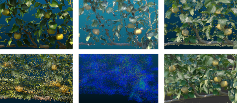
Practical three-dimensional (3D) phenotyping in large-scale orchards with repetitive row structures remains challenging, and systematic evidence comparing both accuracy and acquisition efficiency under outdoor conditions remains limited. This study presents a field-deployable evaluation framework and implements it in a 2-ha commercial Japanese pear orchard trained under a joint V-trellis system. Using a terrestrial laser scanner (TLS) as the reference, we evaluated two handheld LiDAR systems (a low-cost SLAM-based system and a high-performance system), structure from motion / multi-view stereo (SfM/MVS) reconstructions from three camera platforms (a digital camera, an action camera, and a 360° camera), and 3D Gaussian splatting (3DGS) constructed from action-camera video. Measurements were taken at two spatial scales to capture scale-dependent effects. In the span-scale survey (4 m), location error was derived from TLS-referenced target coordinate differences, and reconstruction error was quantified using cloud-to-mesh distances with cubic targets. In the row-scale survey (one tree row), positional stability during continuous mapping was evaluated as location error. Operational metrics (acquisition time, data volume, and processing effort) were also documented. The results demonstrate clear trade-offs among the methods: LiDAR enables rapid wide-area acquisition but is susceptible to cumulative drift in row-structured environments, whereas SfM/MVS provides superior geometric fidelity at the cost of increased time and data volume. Although 3DGS is less suitable for precise quantitative measurement, it demonstrates strong potential for intuitive visualization of orchard structure and fruit distribution. These findings highlight the need for staged, purpose-specific, and seasonally adaptive strategies for orchard-scale digital twin development.
3D sensing comparison in orchard
- [1] S. A. Bound, “Crop load management in nashi pear—A review,” Horticulturae, Vol.8, No.10, Article No.923, 2022. https://doi.org/10.3390/horticulturae8100923
- [2] J. E. Kim et al., “A pruning criterion for dormant ‘Niitaka’ pear trees that uses a decision tree model based on the basal diameter of bearing branches,” Horticultural Science and Technology, Vol.43, No.6, pp. 673-684, 2025. https://doi.org/10.7235/HORT.20250059
- [3] Y. Huang, Z. Ren, D. Li, and X. Liu, “Phenotypic techniques and applications in fruit trees: A review,” Plant Methods, Vol.16, Article No.107, 2020. https://doi.org/10.1186/s13007-020-00649-7
- [4] T. L. Robinson, S. A. Hoying, and G. H. Reginato, “The tall spindle apple production system,” New York Fruit Quarterly, Vol.14, No.2, pp. 21-28, 2006.
- [5] K. Shibata, K. Koizumi, T. Seki, I. Kitao, and K. Matsushita, “A ‘joint tree’ training system enables early returns on Japanese pear orchards,” Acta Horticulturae, Vol.800, pp. 769-776, 2008. https://doi.org/10.17660/ActaHortic.2008.800.105
- [6] T. Seki, K. Hirose, and K. Shibata, “Yield and fruit quality of Japanese pear in ‘joint V-shaped trellis’,” Acta Horticulturae, Vol.1303, pp. 171-176, 2021. https://doi.org/10.17660/ActaHortic.2021.1303.25
- [7] T. Seki, K. Katayama, T. Soneda, and K. Shibata, “Productivity and labor saving effect of Japanese pear in ‘joint V-shaped trellis’,” Acta Horticulturae, Vol.1404, pp. 47-54, 2024. https://doi.org/10.17660/ActaHortic.2024.1404.7
- [8] Japan Fruit Association, “Report on the dissemination and adoption of labor-saving training systems in 2023,” 2024. https://www.japanfruit.jp/Portals/0/resources/JFF/kokunai/r05chosa_siryo/R5Shouryoku.pdf [Accessed March 9, 2026]
- [9] N. Yan et al., “Estimation of pear tree leaf area index using fused UAV multispectral and RGB imagery,” Smart Agricultural Technology, Vol.13, Article No.101717, 2026. https://doi.org/10.1016/j.atech.2025.101717
- [10] A. I. B. Parico and T. Ahamed, “Real time pear fruit detection and counting using YOLOv4 models and Deep SORT,” Sensors, Vol.21, No.14, Article No.4803, 2021. https://doi.org/10.3390/s21144803
- [11] K. Itakura, Y. Narita, S. Noaki, and F. Hosoi, “Automatic pear and apple detection by videos using deep learning and a Kalman filter,” OSA Continuum, Vol.4, No.5, pp. 1688-1695, 2021. https://doi.org/10.1364/OSAC.424583
- [12] B. Lavaquiol, R. Sanz, J. Llorens, J. Arnó, and A. Escolà, “A photogrammetry-based methodology to obtain accurate digital ground-truth of leafless fruit trees,” Computers and Electronics in Agriculture, Vol.191, Article No.106553, 2021. https://doi.org/10.1016/j.compag.2021.106553
- [13] H. F. Murcia, S. Tilaguy, and S. Ouazaa, “Development of a low-cost system for 3D orchard mapping integrating UGV and LiDAR,” Plants, Vol.10, No.12, Article No.2804, 2021. https://doi.org/10.3390/plants10122804
- [14] A. Hayashi, N. Kochi, K. Kodama, S. Isobe, and T. Tanabata, “CLCFM3: A 3D reconstruction algorithm based on photogrammetry for high-precision whole plant sensing using all-around images,” Sensors, Vol.25, No.18, Article No.5829, 2025. https://doi.org/10.3390/s25185829
- [15] J. Gené-Mola, R. Sanz-Cortiella, J. R. Rosell-Polo, A. Escolà, and E. Gregorio, “In-field apple size estimation using photogrammetry-derived 3D point clouds: Comparison of 4 different methods considering fruit occlusions,” Computers and Electronics in Agriculture, Vol.188, Article No.106343, 2021. https://doi.org/10.1016/j.compag.2021.106343
- [16] Q. Bing, R. Zhang, L. Zhang, L. Li, and L. Chen, “UAV-SfM photogrammetry for canopy characterization toward unmanned aerial spraying systems precision pesticide application in an orchard,” Drones, Vol.9, No.2, Article No.151, 2025. https://doi.org/10.3390/drones9020151
- [17] N. Kochi, S. Isobe, A. Hayashi, K. Kodama, and T. Tanabata, “Introduction of all-around 3D modeling methods for investigation of plants,” Int. J. Automation Technol., Vol.15, No.3, pp. 301-312, 2021. https://doi.org/10.20965/ijat.2021.p0301
- [18] B. Lavaquiol-Colell et al., “A methodology for the realistic assessment of 3D point clouds of fruit trees in full 3D context,” Computers and Electronics in Agriculture, Vol.232, Article No.110082, 2025. https://doi.org/10.1016/j.compag.2025.110082
- [19] B. Mildenhall et al., “NeRF: Representing scenes as neural radiance fields for view synthesis,” Proc. of the 16th European Conf. on Computer Vision, pp. 405-421, 2020. https://doi.org/10.1007/978-3-030-58452-8_24
- [20] B. Kerbl, G. Kopanas, T. Leimkuehler, and G. Drettakis, “3D Gaussian splatting for real-time radiance field rendering,” ACM Trans. on Graphics, Vol.42, No.4, Article No.139, 2023. https://doi.org/10.1145/3592433
- [21] M. Li et al., “Apple fruit diameter and length estimation by using the thermal and sunshine hours approach and its application to the digital orchard management information system,” PLOS ONE, Vol.10, No.4, Article No.e0120124, 2015. https://doi.org/10.1371/journal.pone.0120124
- [22] Z. Su et al., “Design of an autonomous orchard navigation system based on multi-sensor fusion,” Agronomy, Vol.14, No.12, Article No.2825, 2024. https://doi.org/10.3390/agronomy14122825
- [23] D. Tiozzo Fasiolo, L. Scalera, E. Maset, and A. Gasparetto, “Towards autonomous mapping in agriculture: A review of supportive technologies for ground robotics,” Robotics and Autonomous Systems, Vol.169, Article No.104514, 2023. https://doi.org/10.1016/j.robot.2023.104514
- [24] S. Rusinkiewicz and M. Levoy, “Efficient variants of the ICP algorithm,” Proc. 3rd Int. Conf. on 3-D Digital Imaging and Modeling, pp. 145-152, 2001. https://doi.org/10.1109/IM.2001.924423
- [25] P. Cignoni, C. Rocchini, and R. Scopigno, “Metro: Measuring error on simplified surfaces,” Computer Graphics Forum, Vol.17, No.2, pp. 167-174, 1998. https://doi.org/10.1111/1467-8659.00236
- [26] N. Aspert, D. Santa-Cruz, and T. Ebrahimi, “MESH: Measuring errors between surfaces using the Hausdorff distance,” Proc. of 2002 IEEE Int. Conf. on Multimedia and Expo, Vol.1, pp. 705-708, 2002. https://doi.org/10.1109/ICME.2002.1035879
- [27] M. Ingman, J.-P. Virtanen, M. T. Vaaja, and H. Hyyppä, “A comparison of low-cost sensor systems in automatic cloud-based indoor 3D modeling,” Remote Sensing, Vol.12, No.16, Article No.2624, 2020. https://doi.org/10.3390/rs12162624
- [28] N. Kochi, T. Tanabata, A. Hayashi, and S. Isobe, “A 3D shape-measuring system for assessing strawberry fruits,” Int. J. Automation Technol., Vol.12, No.3, pp. 395-404, 2018. https://doi.org/10.20965/ijat.2018.p0395
- [29] J. Li et al., “Structural parameter determination and pruning pattern analysis of pear tree shoots for dormant pruning,” Plant Phenomics, Vol.7, No.4, Article No.100136, 2025. https://doi.org/10.1016/j.plaphe.2025.100136
- [30] T. Kawai et al., “Estimation of the amount of pruning in peach using 3D point cloud data,” Horticultural Research (Japan) Supplement, Vol.23, No.1, p. 69, 2024 (in Japanese).
- [31] J. Lee, E. Morimoto, K. Nonami, A. Tanino, and T. Yamaguchi, “Development of tree vigor evaluation method for Japanese pear by 3D point cloud data,” J. of Japanese Society of Agricultural Technology Management, Vol.29, No.2, pp. 41-46, 2022 (in Japanese).
- [32] C. Zhang et al., “Apple tree branch information extraction from terrestrial laser scanning and backpack-LiDAR,” Remote Sensing, Vol.12, No.21, Article No.3592, 2020. https://doi.org/10.3390/rs12213592
- [33] L. Ferreira et al., “Comparative analysis of TLS and UAV sensors for estimation of grapevine geometric parameters,” Sensors, Vol.24, No.16, Article No.5183, 2024. https://doi.org/10.3390/s24165183
- [34] R. de Silva et al., “Semantic-aware particle filter for reliable vineyard robot localisation,” arXiv:2509.18342, 2025. https://doi.org/10.48550/arXiv.2509.18342
- [35] Y. Li, Q. Feng, C. Ji, J. Sun, and Y. Sun, “GNSS and LiDAR integrated navigation method in orchards with intermittent GNSS dropout,” Applied Sciences, Vol.14, No.8, Article No.3231, 2024. https://doi.org/10.3390/app14083231
- [36] M. Hrdina et al., “Obtaining the highest quality from a low-cost mobile scanner: A comparison of several pipelines with a new scanning device,” Remote Sensing, Vol.17, No.15, Article No.2564, 2025. https://doi.org/10.3390/rs17152564
- [37] M. Balestra et al., “Advancing forest inventory: A comparative study of low-cost MLS lidar device with professional laser scanners,” The Int. Archives of the Photogrammetry, Remote Sensing and Spatial Information Sciences, Vol.XLVIII-2/W8-2024, pp. 9-15, 2024. https://doi.org/10.5194/isprs-archives-XLVIII-2-W8-2024-9-2024
- [38] M. R. James and S. Robson, “Straightforward reconstruction of 3D surfaces and topography with a camera: Accuracy and geoscience application,” J. of Geophysical Research: Earth Surface, Vol.117, No.F3, Article No.F03017, 2012. https://doi.org/10.1029/2011JF002289
- [39] S. Jiang, K. You, Y. Li, D. Weng, and W. Chen, “3D reconstruction of spherical images: A review of techniques, applications, and prospects,” Geo-spatial Information Science, Vol.27, No.6, pp. 1959-1988, 2024. https://doi.org/10.1080/10095020.2024.2313328
- [40] G. Kafataris, D. Skarlatos, M. Vlachos, and A. Agapiou, “Investigating the accuracy of a 360° camera for 3D modeling in confined spaces: 360° panorama vs 25-rig compared to TLS,” ISPRS Annals of the Photogrammetry, Remote Sensing and Spatial Information Sciences, Vol.X-M-2-2025, pp. 139-146, 2025. https://doi.org/10.5194/isprs-annals-X-M-2-2025-139-2025
- [41] I. Petrovska and B. Jutzi, “3D Gaussian splatting methods for real-world scenarios,” ISPRS Annals of the Photogrammetry, Remote Sensing and Spatial Information Sciences, Vol.X-G-2025, pp. 641-648, 2025. https://doi.org/10.5194/isprs-annals-X-G-2025-641-2025
- [42] I. Petrovska and B. Jutzi, “Impact of rain on 3D reconstruction with multi-view stereo, neural radiance fields and Gaussian splatting,” ISPRS Annals of the photogrammetry, remote sensing and spatial information sciences, Vol.X-4/W6-2025, pp. 169-176, 2025. https://doi.org/10.5194/isprs-annals-X-4-W6-2025-169-2025
- [43] F. Li et al., “CountingFruit: Language-guided 3D fruit counting with semantic Gaussian splatting,” arXiv:2506.01109, 2025. https://doi.org/10.48550/arXiv.2506.01109
- [44] J. Li et al., “A survey on 3D reconstruction techniques in plant phenotyping: From classical methods to Neural Radiance Fields (NeRF), 3D Gaussian Splatting (3DGS), and beyond,” Plant Phenomics, Vol.7, No.4, Article No.100137, 2025. https://doi.org/10.1016/j.plaphe.2025.100137
- [45] P. Tang, B. Akinci, and D. Huber, “Quantification of edge loss of laser scanned data at spatial discontinuities,” Automation in Construction. Vol.18, No.8, pp. 1070-1083, 2009. https://doi.org/10.1016/j.autcon.2009.07.001
- [46] M. S. Nielsen, I. Nikolov, E. K. Kruse, J. Garnæs, and C. B. Madsen, “Quantifying the influence of surface texture and shape on structure from motion 3D reconstructions,” Sensors. Vol.23, No.1, Article No.178, 2023. https://doi.org/10.3390/s23010178
- [47] J. Torres-Sánchez et al., “Configuration and specifications of an autonomous quadruped robot with an embedded LiDAR sensor for characterizing woody crop canopies,” Precision Agriculture ’25 (Proc. of the 15th European Conf. on Precision Agriculture), pp. 481-487, 2025. https://doi.org/10.1163/9789004725232_062
- [48] E. Wetzel, J. Liu, T. Leathem, and A. Sattineni, “The use of Boston Dynamics SPOT in support of LiDAR scanning on active construction sites,” Proc. of the 39th ISARC, pp. 86-92, 2022. https://doi.org/10.22260/ISARC2022/0014
This article is published under a Creative Commons Attribution-NoDerivatives 4.0 Internationa License.