Paper:
Automated Building Structural Parameters Extraction for Seismic Risk Assessment in Villa El Salvador Area
Jhianpiere Salinas*,†
 , Miguel Diaz*
, Carlos Zavala*
, Masashi Matsuoka**
, Italo Inocente***
, and Fernando Garcia*
, Miguel Diaz*
, Carlos Zavala*
, Masashi Matsuoka**
, Italo Inocente***
, and Fernando Garcia*
*Centro Peruano Japonés de Investigaciones Sísmicas y Mitigación de Desastres, Facultad de Ingeniería Civil, Universidad Nacional de Ingeniería
Av. Tupac Amaru 1150, Rimac, Lima 15333, Peru
†Corresponding author
**School of Environment and Society, Institute of Science Tokyo
Yokohama, Japan
***Graduate School of Engineering, Chiba University
Chiba, Japan

Seismic risk assessment is essential for reducing earthquake-related damage in urban areas. Accurate recognition of building features is a key factor in evaluating seismic vulnerability, yet traditional manual inspection methods are inefficient and prone to error. This study proposes a deep learning-based framework using convolutional neural networks for automated instance segmentation of building features to support seismic risk estimation in Lima, Peru, a seismically active region with diverse architectural styles. Leveraging state-of-the-art models like Mask R-CNN, the framework identifies and segments structural components such as walls, windows, and columns from building imagery. By integrating geospatial data and remote sensing technologies, the proposed approach enhances seismic risk evaluations through automated, scalable, and precise feature recognition. Despite challenges such as occlusions, varying lighting conditions, and architectural diversity, the model aims to adapt through specialized training tailored to Lima’s urban landscape, contributing to more efficient disaster preparedness and response in earthquake-prone regions.
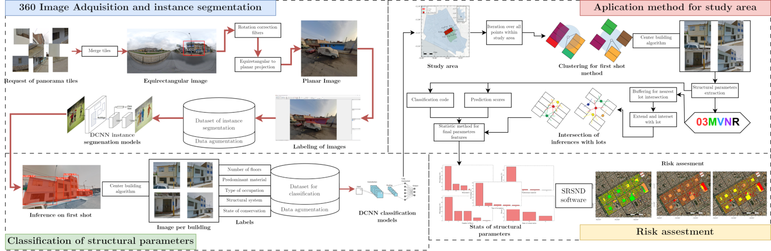
Building parameter extraction workflow
- [1] M. Diaz, C. Zavala, M. Estrada, and M. Matsuoka, “Characterization of the structural typologies of buildings in the Lima Metropolitan Area,” J. Disaster Res., Vol.18, No.4, pp. 329-337, 2023. https://doi.org/10.20965/jdr.2023.p0329
- [2] G. Jocher and J. Qiu, “Ultralytics YOLO11,” 2024. https://github.com/ultralytics/ultralytics [Accessed November 26, 2024]
- [3] J. A. S. Centeno and A. Miqueles, “Extraction of buildings in Brasilian urban environments using high resolution remote sensing imagery and laser scanner data,” ISPRS Archives, Vol.35, Part B4, pp. 589-592, 2004.
- [4] S. Law, B. Paige, and C. Russell, “Take a look around: Using street view and satellite images to estimate house prices,” ACM Trans. on Intelligent Systems and Technology (TIST), Vol.10, No.5, pp. 1-19, 2019. https://doi.org/10.1145/3342240
- [5] M. Li, A. Stein, W. Bijker, and Q. Zhan, “Urban land use extraction from very high resolution remote sensing imagery using a bayesian network,” ISPRS J. of Photogrammetry and Remote Sensing, Vol.122, pp. 192-205, 2016. https://doi.org/10.1016/j.isprsjprs.2016.10.007
- [6] P. A. Pelizari, C. Geiß, P. Aguirre, H. Santa María, Y. M. Peña, and H. Taubenböck, “Automated building characterization for seismic risk assessment using street-level imagery and deep learning,” ISPRS J. of Photogrammetry and Remote Sensing, Vol.180, pp. 370-386, 2021. https://doi.org/10.1016/j.isprsjprs.2021.07.004
- [7] C. Wang, S. E. Antos, and L. M. Triveno, “Automatic detection of unreinforced masonry buildings from street view images using deep learning-based image segmentation,” Automation in Construction, Vol.132, Article No.103968, 2021. https://doi.org/10.1016/j.autcon.2021.103968
- [8] J. Kang, M. Körner, Y. Wang, H. Taubenböck, and X. X. Zhu, “Building instance classification using street view images,” ISPRS J. of Photogrammetry and Remote Sensing, Vol.145, pp. 44-59, 2018. https://doi.org/10.1016/j.isprsjprs.2018.02.006
- [9] Y. Ogawa, C. Zhao, T. Oki, S. Chen, and Y. Sekimoto, “Deep learning approach for classifying the built year and structure of individual buildings by automatically linking street view images and GIS building data,” IEEE J. of Selected Topics in Applied Earth Observations and Remote Sensing, Vol.16, pp. 1740-1755, 2023. https://doi.org/10.1109/JSTARS.2023.3237509
- [10] J. P. Camayang, O. Dela Cruz, and R. Grutas, “Integrating building-and site-specific and generic fragility curves into seismic risk assessment: A prisma-based analysis of methodologies and applications.” CivilEng, Vol.5, No.4, pp. 1011-1041, 2024. https://doi.org/10.3390/civileng5040050
- [11] I. Olteanu-donţov and O.-M. Banu, “Structural vulnerability and risk assessment in seismic areas,” Buletinul Institutului Politehnic din lasi. Sectia Constructii, Arhitectura, Vol.66, No.4, pp. 71-84, 2020.
- [12] S. Brzev, C. Scawthorn, A. W. Charleson, L. Allen, M. Greene, K. Jaiswal, and V. Silva, “GEM building taxonomy (version 2.0),” GEM Technical Report 2013-02, GEM Foundation, 2013.
- [13] Federal Emergency Management Agency (FEMA), “Hazus – MH 2.1 hurricane model user manual,” Technical Report, 2014. https://www.fema.gov/sites/default/files/2020-09/fema_hazus_hurricane-model_user-manual_2.1.pdf [Accessed October 28, 2024]
- [14] P. Mouroux and B. L. Brun, “Presentation of RISK-UE project,” Bulletin of Earthquake Engineering, Vol.4, pp. 323-339, 2006. https://doi.org/10.1007/s10518-006-9020-3
- [15] P. Kourehpaz, C. Molina Hutt, N. A. Marafi, J. W. Berman, and M. O. Eberhard, “Estimating economic losses of midrise reinforced concrete shear wall buildings in sedimentary basins by combining empirical and simulated seismic hazard characterizations,” Earthquake Engineering & Structural Dynamics, Vol.50, No.1, pp. 26-42, 2021. https://doi.org/10.1002/eqe.3325
- [16] R. B. B. Lingamen and J. P. L. Bersamina, “Seismic risk assessment of structures: A review of its methods and applications,” Advances in Civil Engineering Materials (ICACE 2023), pp. 923-951, 2024. https://doi.org/10.1007/978-981-97-0751-5_78
- [17] Centro Peruano Japonés de Investigaciones Sísmicas y Mitigación de Desastres (CISMID), “Estudio de microzonificación sísmica y evaluación de la vulnerabilidad de edificaciones en el distrito de villa el salvador, lima,” Universidad Nacional de Ingeniería, Technical Report, 2011.
- [18] C. Zavala, Z. Aguilar, and M. Estrada, “Evaluation of SRSND simulator against fragility curves for Pisco Quake,” 8th Center for Urban Earthquake Engineering Conf., pp. 89-92, 2011.
- [19] Google LLC, “Google Maps JavaScript API v3 Reference,” Developer Documentation, 2025. https://developers.google.com/maps/documentation/javascript/reference [Accessed July 15, 2025]
- [20] M. Fowler, “Python Concurrency with asyncio,” Simon and Schuster, 2022.
- [21] M. R. Ackermann, J. Blömer, D. Kuntze, and C. Sohler, “Analysis of agglomerative clustering,” Algorithmica, Vol.69, No.1, pp. 184-215, 2014. https://doi.org/10.1007/s00453-012-9717-4
- [22] K. Wada et al., “Labelme: Image Polygonal Annotation with Python.” https://doi.org/10.5281/zenodo.5711226
- [23] K. He, G. Gkioxari, P. Dollár, and R. Girshick, “Mask R-CNN,” Proc. of the IEEE Int. Conf. on Computer Vision, pp. 2961-2969, 2017. https://doi.org/10.1109/ICCV.2017.322
- [24] B. Cheng, I. Misra, A. G. Schwing, A. Kirillov, and R. Girdhar, “Masked-attention mask transformer for universal image segmentation,” 2022 IEEE/CVF Conf. on Computer Vision and Pattern Recognition (CVPR), pp. 1280-1289, 2022. https://doi.org/10.1109/CVPR52688.2022.00135
- [25] T. Lin, M. Maire, S. J. Belongie, L. D. Bourdev, R. B. Girshick, J. Hays, P. Perona, D. Ramanan, P. Dollár, and C. L. Zitnick, “Microsoft COCO: Common objects in context,” Computer Vision (ECCV’2014), pp. 740-755, 2014. https://doi.org/10.1007/978-3-319-10602-1_48
- [26] National Center for Estimation, Prevention and Risk Reduction of Disasters (CENEPRED), “Geographic information system for disaster risk management – SIGRID,” , 2025 (in Spanish). https://sigrid.cenepred.gob.pe/sigridv3 [Accessed February 15, 2025]
- [27] O. Russakovsky, J. Deng, H. Su, J. Krause, S. Satheesh, S. Ma, Z. Huang, A. Karpathy, A. Khosla, M. Bernstein, A. C. Berg, and L. Fei-Fei, “Imagenet large-scale visual recognition challenge,” Proc. of the IEEE Conf. on Computer Vision and Pattern Recognition (CVPR), 2015. https://doi.org/10.1109/CVPR.2015.7298594
- [28] B. Zoph, V. Vasudevan, J. Shlens, and Q. V. Le, “Learning transferable architectures for scalable image recognition,” arXiv:1707.07012, 2018. https://arxiv.org/abs/1707.07012
- [29] M. Tan and Q. V. Le, “EfficientNet: Rethinking model scaling for convolutional neural networks,” 2020. https://arxiv.org/abs/1905.11946
- [30] I. Radosavovic, R. P. Kosaraju, R. Girshick, K. He, and P. Dollár, “Designing network design spaces,” arXiv:1905.11946, 2020. https://arxiv.org/abs/2003.13678
- [31] D. Qin, C. Leichner, M. Delakis, M. Fornoni, S. Luo, F. Yang, W. Wang, C. Banbury, C. Ye, B. Akin, V. Aggarwal, T. Zhu, D. Moro, and A. Howard, “Mobilenetv4 – Universal models for the mobile ecosystem,” arXiv:2404.10518, 2024. https://arxiv.org/abs/2404.10518
- [32] J. Redmon, S. Divvala, R. Girshick, and A. Farhadi, “You Only Look Once: Unified, real-time object detection,” arXiv:1506.02640, 2016. https://arxiv.org/abs/1506.02640
- [33] SENCICO, “Technical standard of buildings e.030: Earthquake-resistant design,” 2018.
This article is published under a Creative Commons Attribution-NoDerivatives 4.0 Internationa License.