Paper:
Enhancing Disaster Risk Reduction at School Through the Integration of Geographic Information System: Insights from Taiwan’s School Safety GIS Platform
Takashi Oda*1,*2,†
 , Aiko Sakurai*2,*3
, Takeshi Sato*2, Chia-Hsin Lee*4,*5, and Chung-Feng Ding*5
, Aiko Sakurai*2,*3
, Takeshi Sato*2, Chia-Hsin Lee*4,*5, and Chung-Feng Ding*5
*1The University of Tokyo
3-8-1 Komaba, Meguro-ku, Tokyo 153-8902, Japan
*2Tohoku University
Sendai, Japan
*3Kobe University
Kobe, Japan
*4Ministry of Education
Taipei, Taiwan
*5National Cheng Kung University
Tainan, Taiwan
†Corresponding author

This study investigates the integration of geographic information systems (GIS) into school disaster risk reduction (DRR) practices, with a specific focus on Taiwan’s School Safety GIS platform. Drawing comparisons with current practices in Japan, this paper highlights the central role of Web-GIS in visualizing hazard risks, enhancing school safety management, and promoting spatial thinking among educators. The case study of Taiwan demonstrates a centralized and systematically updated GIS platform that facilitates comprehensive risk assessments, real-time hazard alerts, and the integration of multi-source governmental data. These findings underscore the importance of geographic literacy, data integration, and inter-agency collaboration for effective DRR in schools. The implications for Japan point to the need for unified GIS adoption and expanded teacher training.
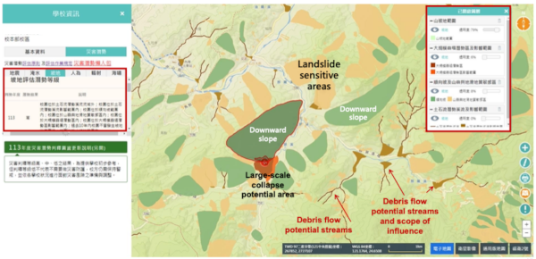
School Safety GIS Platform (Landslide Hazard)
- [1] N. Sulaiman et al., “Geographical information system (GIS) and remote sensing (RS) applications in disaster risk reduction (DRR) in Malaysia,” Int. J. Integr. Eng., Vol.14, No.5, pp. 25-37, 2022. https://doi.org/10.30880/ijie.2022.14.05.003
- [2] T. Nagata, M. Ikeda, R. Kimura, and T. Oda, “Development of tsunami disaster risk reduction education program for children with no experience of earthquake disaster – Practice and verification at Shichigahama Town, Miyagi Prefecture,” J. Disaster Res., Vol.17, No.6, pp. 1000-1014, 2022. https://doi.org/10.20965/jdr.2022.p1000
- [3] J. Song et al., “Effects of web geographic information system (GIS) technology and curriculum approaches on education for disaster risk reduction,” Nat. Hazards Earth Syst. Sci., Vol.23, No.11, pp. 3617-3634, 2023. https://doi.org/10.5194/nhess-23-3617-2023
- [4] Y. Suzuki et al., “Hazard mapping and geography: Why hazard mapping projects are now strongly promoted,” Geogr. Rev. Jpn., Vol.76, No.12, pp. 924-930, 2003. https://doi.org/10.4157/grj.76.12_924
- [5] A. Sakurai, Y. Murayama, T. Sato, and T. Oda, “Climate and disaster risk reduction education,” R. Shaw (Ed.), “Handbook on Climate Change and Disasters,” pp. 322-329, Edward Elgar Publishing, 2022. https://doi.org/10.4337/9781800371613.00035
- [6] P. T. Apronti, S. Osamu, K. Otsuki, and G. Kranjac-Berisavljevic, “Education for disaster risk reduction (DRR): Linking theory with practice in Ghana’s basic schools,” Sustainability, Vol.7, No.7, pp. 9160-9186, 2015. https://doi.org/10.3390/su7079160
- [7] A. Sakurai, T. Oda, Y. Murayama, and T. Sato, “Linking geomorphological features and disaster risk in a school district: The development of an in-service teacher training programme,” IOP Conf. Ser.: Earth Environ. Sci., Vol.630, Article No.012021, 2021. https://doi.org/10.1088/1755-1315/630/1/012021
- [8] J. Song, H. Yamauchi, T. Oguchi, and T. Ogura, “Application of web hazard maps to high school education for disaster risk reduction,” Int. J. Disaster Risk Reduct., Vol.72, Article No.102866, 2022. https://doi.org/10.1016/j.ijdrr.2022.102866
- [9] I. Kholoshyn, T. Nazarenko, O. Bondarenko, O. Hanchuk, and I. Varfolomyeyeva, “The application of geographic information systems in schools around the world: A retrospective analysis,” J. Phys.: Conf. Ser., Vol.1840, Article No.012017, 2021. https://doi.org/10.1088/1742-6596/1840/1/012017
- [10] A. Beikitova, K. Kaimuldinova, G. Berdygulova, G. Sabdenalieva, and G. Abdikarimova, “Crafting cartographic competence: A methodological approach for nurturing future geography teachers,” Sci. Her. Uzhhorod Univ. Ser. “Phys.”, No.55, pp. 2911-2918, 2023. https://doi.org/10.54919/physics/55.2024.291am1
- [11] A. Sakurai, “Toward effective and sustainable school disaster preparedness,” Proc. Annu. Meet. Assoc. Jpn. Geogr. Spring 2025, Article No.S302, 2025 (in Japanese). https://doi.org/10.14866/ajg.2025s.0_96
This article is published under a Creative Commons Attribution-NoDerivatives 4.0 Internationa License.