Paper:
Quantitative Evaluation of Sediment Dynamics in the Pankenushi River Basin, Saru River System, Hokkaido, Japan, Following Heavy Rain in August 2016
Hiromi Akita†

Research Division for Storm, Flood and Landslide Disasters, National Research Institute for Earth Science and Disaster Resilience
3-1 Tennodai, Tsukuba, Ibaraki 305-0006, Japan
†Corresponding author

This study provides a quantitative assessment of sediment dynamics associated with newly formed landslides and river channels in the Pankenushi River basin (95.8 km2), part of the Saru River system in Hokkaido, Japan. The analysis focuses on the impacts of the torrential rainfalls induced by four typhoons, including Typhoon Lionrock, which occurred between August 17 and 31, 2016. Using satellite imagery and laser profiler (LP) measurements, the study quantifies the spatial extent and volumetric changes in sediment dynamics. The areas affected by newly formed landslides and river channel disturbances were identified by analyzing changes in the normalized difference vegetation index calculated using images from before and after the heavy rainfall events. In the middle and lower reaches of the river, where channel disturbance was pronounced, LP measurements conducted in 2012 and 2019 were used to estimate topographic changes resulting from the rainfall and runoff. Sediment erosion volume was estimated at approximately 880,000 m3, approximately three times greater than the volume of channel deposits (310,000 m3) and about five times greater than the volume supplied by shallow landslides in the upper basin. These findings indicate that riverbank erosion, in addition to landslides, plays a substantial role in sediment runoff during extreme rainfall events, such as that in August 2016.
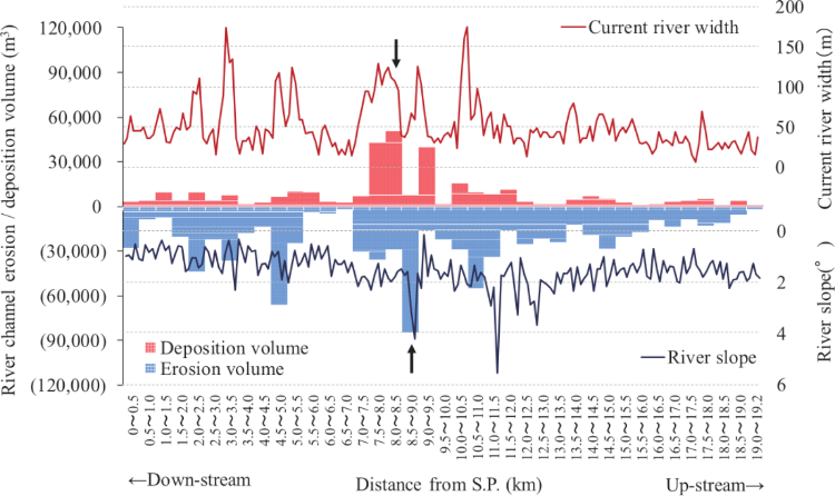
Volume of channel erosion and deposition in the river.
- [1] Japan Meteorological Agency, “Global warming prediction information volume 9,” 2017 (in Japanese). https://www.data.jma.go.jp/cpdinfo/GWP/Vol9/pdf/all.pdf [Accessed May 20, 2023]
- [2] J. Hirschberg, S. Fatichi, G. L. Bennett, B. W. McArdell, N. Peleg, S. N. Lane, F. Schlunegger, and P. Molnar, “Climate change impacts on sediment yield and debris-flow activity in an Alpine catchment,” J. of Geophysical Research: Earth Surface, Vol.126, Issue 1, Article No.e2020JF005739, 2021. https://doi.org/10.1029/2020JF005739
- [3] S. Mizugaki, M. Sasage, and D. Otajima, “Suspended sediment discharge from the August 2016 heavy rainfall in the Mukawa and Saru River systems,” Proc. of the 61st Hokkaido Development Technology Conf. (FY 2017), 2018 (in Japanese).
- [4] T. Kurahashi, Y. Ito, K. Agui, F. Tsunoda, and S. Yamazaki, “Report on torrential rain disaster in Hokkaido in August–September 2016: 2. Damage to roads (slopes),” Monthly Report of the Civil Engineering Research Institute for Cold Regions, No.769, pp. 48-57, 2017 (in Japanese).
- [5] O. Shimizu and S. Maeda, “Research on reach-scale sediment dynamics by repeated surveys of channel cross-sections: Rubeshubenai Creek, Hokkaido,” J. of the Japan Society of Erosion Control Engineering, Vol.69, No.2, pp. 36-40, 2016 (in Japanese). https://doi.org/10.11475/sabo.69.2_36
- [6] T. Hayakawa, Y. Murakami, S. Mizugaki, and K. Watanabe, “The sediment discharge characterristics in Saru River by heavy rain in August 2016,” Proc. of the 9th Symp. on Sediment-Related Disasters, 2018 (in Japanese).
- [7] H. Akita, S. Mizugaki, and Y. Murakami, “Distribution of landslide areas in the upper reaches of the Saru River due to heavy rainfall on August 30–31, 2016,” Proc. of the 63rd Hokkaido Development Technology Conf. (FY 2019), pp. 470-475, 2020 (in Japanese).
- [8] Y. Murano, “Study of landslides of heavy rain type,” J. of the Erosion-Control Engineering Society, Vol.19, No.4, pp. 1-6, 1967 (in Japanese). https://doi.org/10.11475/sabo1948.19.4_1
- [9] J. Iwahashi, H. Yamagishi, I. Kamiya, and H. Sato, “Discriminant analysis for landslides caused by the 2004 Niigata heavy rainfall in July and the mid Niigata Prefecture earthquake in October,” J. of the Japan Landslide Society, Vol.45, No.1, pp. 1-12, 2008 (in Japanese). https://doi.org/10.3313/jls.45.1
- [10] M. Tsushima, T. Uchida, and T. Yamakoshi, “Spatial variability in heavy rainfall induced sediment discharge volume from mountain catchments with similar topography, geology and rainfall conditions,” J. of the Japan Society of Erosion Control Engineering, Vol.73, No.3, pp. 25-34, 2020. https://doi.org/10.11475/sabo.73.3_25
- [11] Hokkaido Research Organization, Research Institute of Energy, Environment and Geology, “1:50,000 scale geological map width (Chiroro, Kushiro-No.40),” 1962 (in Japanese). https://www.gsj.jp/Map/JP/docs/5man_doc/02/02_040.htm [Accessed May 20, 2023]
- [12] Hokkaido Research Organization, Research Institute of Energy, Environment and Geology, “1:50,000 scale geological map width (Mikage, Kushiro-No.41),” 1954 (in Japanese). https://www.gsj.jp/Map/JP/docs/5man_doc/02/02_041.htm [Accessed May 20, 2023]
- [13] Hokkaido Research Organization, Research Institute of Energy, Environment and Geology, “1:50,000 scale geological map width (Poroshiridake, Kushiro-No.50),” 1961 (in Japanese). https://www.gsj.jp/Map/JP/docs/5man_doc/02/02_050.htm [Accessed May 20, 2023]
- [14] C. J. Tucker, “Red and photographic infrared linear combinations for monitoring vegetation,” Remote Sensing of Environment, Vol.8, Issue 2, pp. 127-150, 1979. https://doi.org/10.1016/0034-4257(79)90013-0
- [15] N. Ebisu, Y. Murase, and T. Marutani, “Mapping of the landslide areas at Mt. Ichifusa using remote sensing data and GIS—A case study of the landslide areas at Mt. Ichifusa—,” J. of the Japan Society of Erosion Control Engineering, Vol.53, No.1, pp. 3-9, 2000 (in Japanese). https://doi.org/10.11475/sabo1973.53.3
- [16] H. Akita, S. Mizugaki, and Y. Murakami, “Landslide areas evaluated from NDVI images with different resolutions,” Monthly Report of the Civil Engineering Research Institute for Cold Regions, No.805, pp. 2-11, 2020 (in Japanese).
- [17] F. Guzzetti, F. Ardizzone, M. Cardinali, M. Rossi, and D. Valigi, “Landslide volumes and landslide mobilization rates in Umbria, central Italy,” Earth and Planetary Science Letters, Vol.279, Issues 3-4, pp. 222-229, 2009. https://doi.org/10.1016/j.epsl.2009.01.005
This article is published under a Creative Commons Attribution-NoDerivatives 4.0 Internationa License.