
Paper:
Modeling School-Bus-Shinkansen Evacuation Strategies for Volcanic Disasters: A Case Study in Kagoshima, Japan
Andreas Keler†
 and Masato Iguchi
Sakurajima Volcanic Disaster Risk Reduction Research Center, Crisis Management Division, Kagoshima City
11-1 Yamashita-cho, Kagoshima, Kagoshima 892-8677, Japan
†Corresponding author

This study examines microscopic evacuation simulations using predefined bus fleets to move residents from affected areas to safety, with a focus on volcanic disasters, an often-overlooked Scenario compared to earthquakes or floods. Stratovolcano eruptions, such as those from Sakurajima near Kagoshima City, can trigger prolonged crises, with massive ash and pumice severely disrupting roads and urban infrastructure. In dense cities, private vehicle evacuations risk extreme congestion, making organized, large-scale bus-based strategies essential. This research models bus fleet operations under conditions of an imminent eruption. Besides following the suggestion of the City of Kagoshima for each household to use the passenger car for evacuating to respective shelters outside the city, we reason on how to evacuate the most vulnerable road users, namely children and elderly people in a fast and safe way, especially during typical working hours of a weekday in the central business district of the city. Therefore, we calculate bus routes connecting specified building types (in our example schools) with the Kagoshima-Chuo Shinkansen Station, enabling the fast evacuation (e.g., to Kumamoto) of a large number of persons. For reasoning about optimal setups for this strategy, we define three different scenarios that use the same traffic flow simulation network, but varying road user agents compositions with (Scenario 1) only simulating evacuation buses, students and teachers entering and exiting them (and walk to a train platform), Shinkansen used to transport the evacuees to Kumamoto Station, (Scenario 2) addition of passenger-car demand estimated from real traffic counts at 287 map-matched detectors on August 5, 2025 (for the Japanese standard time between 7:15 and 13:15), and (Scenario 3) all students and teachers are walking (as pedestrian road users) from respective school bus stops to the Kagoshima-Chuo Shinkansen Station (with passenger-car traffic demand from Scenario 2). After discussing the respective simulation outcomes, we suggest further simulation scenarios for future research.
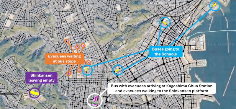
School-Bus-Shinkansen evacuation process
- [1] M. Iguchi, “Integrated research on large-scale eruption at Sakurajima Volcano,” J. Disaster Res., Vol.20, No.2, pp. 186-196, 2025. https://doi.org/10.20965/jdr.2025.p0186
- [2] K. Sugo, M. Onishi, Y. Yama, M. Iguchi, G. Nakano, K. Takenouchi, K. Yamori, and H. Shimamoto, “Study on the process of behavioral change of local residents in preparation for a large-scale eruption of Sakurajima,” J. Disaster Res., Vol.20, No.3, pp. 342-357, 2025. https://doi.org/10.20965/jdr.2025.p0342
- [3] Kagoshima City, “Kagoshima City Plan for Responding to Massive Tephra Fall,” Kagoshima City Hall, Kagoshima, 2023. https://www.city.kagoshima.lg.jp/kikikanri/documents/tairyoukaruishikazanbaitaioukeikaku202607.pdf [Accessed September 15, 2026]
- [4] M. Kanai, “Report on the eruption of Sakurajima volcano in the year 1914, and on the investigation and experiments concerning the eruptive materials and crop cultivation,” Kagoshima Higher Agricultural and Forestry School, 1920 (in Japanese).
- [5] M. Iguchi, “Chapter 18 – Volcano emergency planning at Sakurajima volcano,” P. Papale (Ed.), “Forecasting and Planning for Volcanic Hazards, Risks, and Disasters,” Vol.2, pp. 635-668, Elsevier, 2021. https://doi.org/10.1016/B978-0-12-818082-2.00018-4
- [6] Kagoshima City, “Population by age (5-year age group) and town/district.” https://www.city.kagoshima.lg.jp/soumu/soumu/soumu/shise/toke-02/jinko/h5-24daicho.html [Accessed January 9, 2026]
- [7] Kagoshima City, “Initiatives to combat traffic congestion.” https://www.city.kagoshima.lg.jp/kensetu/douro/gairoseibi/juutaitaisaku.html [Accessed January 9, 2026]
- [8] J. L. Renne, “Emergency evacuation planning policy for carless and vulnerable populations in the United States and United Kingdom,” Int. J. of Disaster Risk Reduction, Vol.31, pp. 1254-1261, 2018. https://doi.org/10.1016/j.ijdrr.2018.02.016
- [9] Y. Kojima, T. Matsunaga, and S. Yamaguchi, “The impact of new Shinkansen lines (Tohoku Shinkansen (Hachinohe–Shin-Aomori) and Kyusyu Shinkansen (Hakata–Shin-Yatsushiro)),” Transportation Research Procedia, Vol.25, pp. 344-357, 2017. https://doi.org/10.1016/j.trpro.2017.05.412
- [10] Japan Designated Cities Mayors’ Association, “Information on the Designated Cities.” https://www.siteitosi.jp/en/about/cities/ [Accessed June 17, 2026]
- [11] Japan Designated Cities Mayors’ Association, “Large-scale disaster response.” https://www.siteitosi.jp/en/about/respond-to-disaster/ [Accessed June 17, 2026]
- [12] C. Y. Lam and A. M. Cruz, “Topological network and fuzzy AHP modeling framework for the suitability analysis of evacuation shelters: A case study in Japan,” Int. J. of Disaster Risk Reduction, Vol.111, Article No.104696, 2024. https://doi.org/10.1016/j.ijdrr.2024.104696
- [13] A. Naobumi and M. Brase, “The Complete Guide to Japanese Systems,” IBC Publishing, 2012.
- [14] M. Iguchi and K. Ishii, “Quantitative forecasting of volcanic ashfall prior to the onset of vulcanian eruption by combining transport and dispersion simulation with ground deformation observation at Sakurajima Volcano, Japan,” J. Disaster Res., Vol.20, No.3, pp. 259-268, 2025. https://doi.org/.10.20965/jdr.2025.p0259
- [15] H. Rahadianto, H. Tatano, and M. Iguchi, “Uncertainty analysis of the prediction of massive ash fallout from a large explosive eruption at Sakurajima Volcano,” Earth and Space Science, Vol.11, No.1, Article No.e2023EA003174, 2024. https://doi.org/10.1029/2023EA003174
- [16] H. Rahadianto, H. Tatano, and M. Iguchi, “Multiscale impact assessment of massive ash fallout from a large eruption: What may happen if Sakurajima Taisho eruption occurs in contemporary Japan?,” J. of Disaster Science and Management, Vol.1, No.1, Article No.24, 2025. https://doi.org/10.1007/s44367-025-00023-1
- [17] K. Kim, P. Pant, E. Yamashita, and J. Ghimire, “Analysis of transportation disruptions from recent flooding and volcanic disasters in Hawai’i,” Transportation Research Record, Vol.2673, No.2, pp. 194-208, 2019. https://doi.org/10.1177/0361198118825460
- [18] E. Tomsen, J. M. Lindsay, M. Gahegan, T. M. Wilson, and D. M. Blake, “Evacuation planning in the Auckland Volcanic Field, New Zealand: A spatio-temporal approach for emergency management and transportation network decisions,” J. of Applied Volcanology, Vol.3, No.1, Article No.6, 2014. https://doi.org/10.1186/2191-5040-3-6
- [19] P. A. Lopez, M Behrisch, L. Bieker-Walz, J. Erdmann, Y.-P. Flötteröd, R. Hilbrich, L. Lücken, J. Rummel, P. Wagner, and E. Wiessner, “Microscopic traffic simulation using SUMO,” 21st Int. Conf. on Intelligent Transportation Systems (ITSC’2018), pp. 2575-2582, 2018. https://doi.org/10.1109/ITSC.2018.8569938
- [20] DLR, “netconvert.” https://sumo.dlr.de/docs/netconvert.html [Accessed January 9, 2026]
- [21] A. Keler, S. Amini, J. Lindner, and K. Bogenberger, “Introducing data-format-dependent road network conversion techniques–Lessons learned from the Digital Twin Munich,” 31st Annual Geographical Information Science Research UK Conf. (GISRUK), 2023. https://doi.org/10.5281/zenodo.7823414
- [22] A. Keler, W. Sun, and J.-D. Schmöcker, “Generating and calibrating a microscopic traffic flow simulation network of Kyoto: First insights from simulating private and public transport,” SUMO Conf. Proc., 2023.
- [23] P. Neis and A. Zipf, “Openrouteservice.org is three times ‘open’: Combining OpenSource, OpenLS and OpenStreetMaps,” GIS Research UK (GISRUK’08), 2008.
- [24] DLR, “tracemapper.py.” https://sumo.dlr.de/docs/Tools/Routes.html#tracemapperpy [Accessed January 9, 2026]
- [25] DLR, “netedit.” https://sumo.dlr.de/docs/Netedit/index.html [Accessed January 9, 2026]
- [26] M. Hojo, “Association between student-teacher ratio and teachers’ working hours and workload stress: evidence from a nationwide survey in Japan,” BMC Public Health, Vol.21, No.1, Article No.1635, 2021. https://doi.org/10.1186/s12889-021-11677-w
- [27] H. D. S. Budiono, G. Heryana, M. Adhitya, D. A. Sumarsono, Nazaruddin, R. Siregar, E. Rijanto, and B. D. Aprianto, “Power requirement and cost analysis of electric bus using simulation method with RCAVe-EV1 software and GPS data; A case study of Greater Jakarta,” Int. J. of Technology, Vol.13, No.4, 2022. https://doi.org/10.14716/ijtech.v13i4.5688
- [28] DLR, “Model striping.” https://sumo.dlr.de/docs/Simulation/Pedestrians.html#model_striping [Accessed January 9, 2026]
- [29] JARTIC, “Cross-sectional traffic volume information for general roads (November 2025).” https://www.jartic.or.jp/service/opendata/ [Accessed January 9, 2026]
- [30] DLR, “Induction Loops Detectors (E1).” https://sumo.dlr.de/docs/Simulation/Output/Induction_Loops_Detectors_%28E1%29.html [Accessed January 9, 2026]
- [31] DLR, “Detector.” https://sumo.dlr.de/docs/Tools/Detector.html [Accessed January 9, 2026]
- [32] H. W. Jürgens, I. Matzdorff, and J. Windberg, “Internationale anthropometrische Daten als Voraussetzung für die Gestaltung von Arbeitsplätzen und Maschinen,” Wirtschaftsverlag NW Verlag für neue Wissenschaft GmbH, 1998. https://www.baua.de/DE/Angebote/Publikationen/AWE/AWE108 [Accessed May 12, 2026]
- [33] DLR, “Vehicle Type Parameter Defaults.” https://sumo.dlr.de/docs/Vehicle_Type_Parameter_Defaults.html [Accessed May 12, 2026]
- [34] J. Erdmann and D. Krajzewicz, “Modelling pedestrian dynamics in SUMO,” SUMO 2015 – Intermodal Simulation for Intermodal Transport, 2015.
- [35] Kagoshima City, “Kagoshima City Traffic Congestion Countermeasure Basic Plan (Revised Draft): Summary.” https://www.city.kagoshima.lg.jp/kensetu/douro/gairoseibi/documents/shiryou2.pdf [Accessed May 15, 2026]
- [36] A. Keler and J. M. Krisp, “Quantifying the complexity of road intersections using open data of traffic accidents–insights from a case study in Munich,” Abstracts of the Int. Cartographic Association, Vol.3, 2021. https://doi.org/10.5194/ica-abs-3-143-2021
- [37] B. Kaltenhäuser, A. Keler, Y. Ma, and J.-D. Schmöcker, “Safer truck routing considering collision severity and route preferences,” 9th Int. Conf. on Models and Technologies for Intelligent Transportation Systems (MT-ITS’2025), 2025. https://doi.org/10.1109/MT-ITS68460.2025.11223555
- [38] Kagoshima City, “City bus GTFS-JP data (revised July 20, 2025).” https://data.bodik.jp/dataset/462012_bus-kagoshimacity-kagoshima-jp [Accessed January 9, 2026]
- [39] DLR, “PT from OpenStreetMap.” https://sumo.dlr.de/docs/Tutorials/PT_from_OpenStreetMap.html [Accessed January 9, 2026]
- [40] A. Keler, L. A. Bug, and J. M. Krisp, “Network-based visualisation of accessibility for a public transport system,” Advances in Cartography and GIScience of the ICA, Vol.1, Article No.7, 2019. https://doi.org/10.5194/ica-adv-1-7-2019
- [41] DLR, “Persons.” https://sumo.dlr.de/docs/Specification/Persons.html [Accessed January 9, 2026]
- [42] DLR, “Using actuated traffic lights.” https://sumo.dlr.de/docs/Simulation/Traffic_Lights.html#using_actuated_traffic_lights [Accessed January 9, 2026]
- [43] DLR, “tlsCycleAdaptation.py.” https://sumo.dlr.de/docs/Tools/tls.html#tlscycleadaptationpy [Accessed January 9, 2026]
- [44] F. Webster, “Traffic signal settings,” Road Research Technical Paper, 1958.
- [45] DLR, “tlsCoordinator.py.” https://sumo.dlr.de/docs/Tools/tls.html#tlscoordinatorpy [Accessed January 9, 2026]
- [46] A. Keler, Y. Song, A. Qureshi, S. Nakao, and J.-D. Schmöcker, “Simulating the impact of adaptive traffic signals on bus energy consumption—A Keihan 300 Kyoto case study,” Proc. of Infrastructure Planning, Vol.71, 2025.
This article is published under a Creative Commons Attribution-NoDerivatives 4.0 Internationa License.