Paper:
Comparing a Single-Hazard Map and a Multi-Risk Overlay Map Based on Design with Nature Process
Misato Uehara*1,†
 , Daiki Shinkai*1, Tomohiro Ichinose*2
, Juichi Yamazaki*3, and Ryohei Yamashita*4
, Daiki Shinkai*1, Tomohiro Ichinose*2
, Juichi Yamazaki*3, and Ryohei Yamashita*4
*1Graduate School of Science and Engineering, Shinshu University
8304 Minami-Minowa, Kamina, Nagano 399-4598, Japan
†Corresponding author
*2Faculty of Environment and Information Studies, Keio University
Fujisawa, Japan
*3Graduate School of Engineering, Kobe University
Kobe, Japan
*4Ishikawa Prefectural University
Nonoichi, Japan

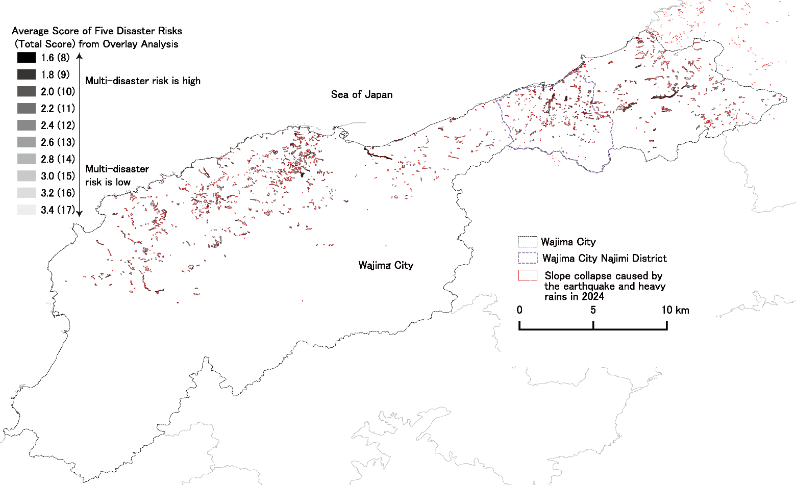
The magnitude 9.0 earthquake and tsunami that struck Japan’s Tohoku region in 2011 highlighted the critical need to integrate disaster risk prediction into post-disaster reconstruction. Building on this perspective, this study evaluates the predictive accuracy and practical utility of two risk assessment methods—the Ministry of Land, Infrastructure, Transport and Tourism hazard map, which is based on single-hazard, uniform physical criteria (single-hazard map), and a multi-hazard overlay map based on McHarg’s ecological planning approach—in the context of the 2024 Noto Peninsula Earthquake and subsequent rainfall-induced sediment disasters in Wajima City. Using QGIS-based spatial analysis, we quantified and compared the spatial overlap between pre-disaster risk predictions and actual sediment-disaster damage. We also examined the relationship between potential housing relocation sites identified through interviews and the two risk maps. The results show that the single-hazard map explained only 16% of the damaged areas in Wajima City and 9% in the Najimi District, whereas the multi-hazard overlay map accounted for all affected zones and clarified the underlying environmental factors. Moreover, the official single-hazard map showed minimal spatial overlap with proposed post-disaster relocation sites. In contrast, the overlay map not only visualized complex multi-hazard risks but also provided insight into differences in disaster risk among potential residential relocation sites and their underlying causes. These findings suggest that reliance on single-hazard maps may result in substantial blind spots in both disaster preparedness and post-disaster recovery. By contrast, overlay-based composite mapping demonstrates both quantitative and qualitative potential for comprehensive regional evaluation and visualization in risk assessment and reconstruction planning.
Design with Nature explains damage patterns beyond single hazards
- [1] Cabinet Office, Government of Japan, “Damage situation of the Great East Japan Earthquake,” White Paper on Disaster Management, 2012.
- [2] Fire and Disaster Management Agency, “Damage report of the 2011 Great East Japan Earthquake (as of March 1, 2024),” Ministry of Internal Affairs and Communications, Japan, 2024.
- [3] NHK, “‘250,000 yen per citizen:’ How the reconstruction budget was spent—Disaster reconstruction in an era of population decline,” Close-up Gendai+, broadcast February 25, 2021.
- [4] Ellen MacArthur Foundation, “Circular economy systems diagram,” 2019. https://content.ellenmacarthurfoundation.org/m/66297aa6740489c4/original/Circular-economy-butterfly-diagram.pdf [Accessed July 14, 2025]
- [5] United Nations, “The 17 Goals: Sustainable Development.” https://sdgs.un.org/goals [Accessed July 9, 2025]
- [6] W. Marzocchi, A. Garcia-Aristizabal, P. Gasparini, M. L. Mastellone, and A. Di Ruocco, “Basic principles of multi-risk assessment: A case study in Italy,” Natural Hazards, Vol.62, No.2, pp. 551-573, 2012. https://doi.org/10.1007/s11069-012-0092-x
- [7] J. C. Gill and B. D. Malamud, “Reviewing and visualizing the interactions of natural hazards,” Reviews of Geophysics, Vol.52, Issue 4, pp. 680-722, 2014.
- [8] M. Uehara, K. H. Liao, Y. Arai, and Y. Masakane, “Could the magnitude of the 3/11 disaster have been reduced by ecological planning? A retrospective multi-hazard risk assessment through map overlay,” Landscape and Urban Planning, Vol.227, Article No.104541, 2022. https://doi.org/10.1016/j.landurbplan.2022.104541
- [9] Geospatial Information Authority of Japan, “Landslide and sediment distribution data: Information on the 2024 Noto Peninsula Earthquake (Reiwa 6),” 2024. https://www.gsi.go.jp/BOUSAI/20240101_noto_earthquake.html [Accessed May 13, 2025]
- [10] Geospatial Information Authority of Japan, “Landslide and sediment distribution data: Information on the heavy rain event beginning on September 20, 2024 (Reiwa 6),” 2024. https://www.gsi.go.jp/BOUSAI/R6_noto_heavyrain.html#8 [Accessed May 13, 2025]
- [11] Ministry of Land, Infrastructure, Transport and Tourism (MLIT), “National Land Numerical Information download service: Sediment disaster (2013) hazard areas (Version 1.1), Ishikawa Prefecture,” 2013. https://nlftp.mlit.go.jp/ksj/gml/datalist/KsjTmplt-A33-v2_0.html [Accessed May 13, 2025]
- [12] I. L. McHarg, “Design with nature,” American Museum of Natural History, pp. 7-17, 1969.
- [13] Planning and Coordination Bureau, National Land Agency of Japan, “Ekoroji-karu puranningu ni yoru tochiriyo tekisei hyoka shuho chosa,” [Survey for Land-Use Suitability Evaluation Methods Using Ecological Planning], 1980.
- [14] Asahi Shimbun Digital, “Noto rainfall death toll rises to 16,” December 21, 2024. https://www.asahi.com/articles/DA3S16108522.html [Accessed July 14, 2025]
- [15] NHK, “Estimated 1,900 locations affected by sediment runoff during record-breaking rainfall on the Noto Peninsula. National Research Institute for Earth Science and Disaster Resilience,” October 5, 2024. https://www3.nhk.or.jp/news/html/20241005/k10014601801000.html [Accessed January 27, 2026]
- [16] Y. Matsushi, “Coseismic landslides in the 2024 Noto Peninsula Earthquake and the cascading disaster: Preliminary observations and perspectives,” DPRI Annuals, No.67(A), pp. 131-140, 2024.
- [17] T. A. Owolabi and M. Sajjad, “A global outlook on multi-hazard risk analysis: A systematic and scientometric review,” Int. J. of Disaster Risk Reduction, Vol.92, Article No.103727, 2023. https://doi.org/10.1016/j.ijdrr.2023.103727
- [18] K. Liu, “GIS-based MCDM framework combined with coupled multi-hazard assessment for site selection of post-earthquake emergency medical service facilities in Wenchuan, China,” Int. J. of Disaster Risk Reduction, Vol.73, Article No.102873, 2022. https://doi.org/10.1016/j.ijdrr.2022.102873
- [19] M. S. Kappes, M. Keiler, K. von Elverfeldt, and T. Glade, “Challenges of analyzing multi-hazard risk: A review,” Natural Hazards, Vol.64, No.2, pp. 1925-1958, 2012. https://doi.org/10.1007/s11069-012-0294-2
- [20] C. Steinitz, P. Parker, and L. Jordan, “Hand-drawn overlays: Their history and prospective uses,” Landscape Architecture, Vol.66, No.5, pp. 444-455, 1976.
This article is published under a Creative Commons Attribution-NoDerivatives 4.0 Internationa License.