Paper:
Probabilistic Tsunami Hazard Assessment Based on Time and Space Dependent Rupture Analysis of the Central Peruvian Subduction Zone
Carlos Davila*1,*2
 , Miguel Estrada*1,*2,†
, Luis Ceferino*3
, Jorge Morales*4
, Fernando Garcia*1,*2
, and Shunichi Koshimura*4
, Miguel Estrada*1,*2,†
, Luis Ceferino*3
, Jorge Morales*4
, Fernando Garcia*1,*2
, and Shunichi Koshimura*4
*1GeoGiRD Research Group, Facultad de Ingeniería Civil, Universidad Nacional de Ingeniería (UNI)
Av. Tupac Amaru 1150, Lima 15333, Peru
*2Geomatics Laboratory, Centro Peruano Japonés de Investigaciones Sísmicas y Mitigación de Desastres
Lima, Peru
*3Department of Civil and Environmental Engineering, University of California
Berkeley, USA
*4International Research Institute of Disaster Science (IRIDeS), Tohoku University
Sendai, Japan
†Corresponding author

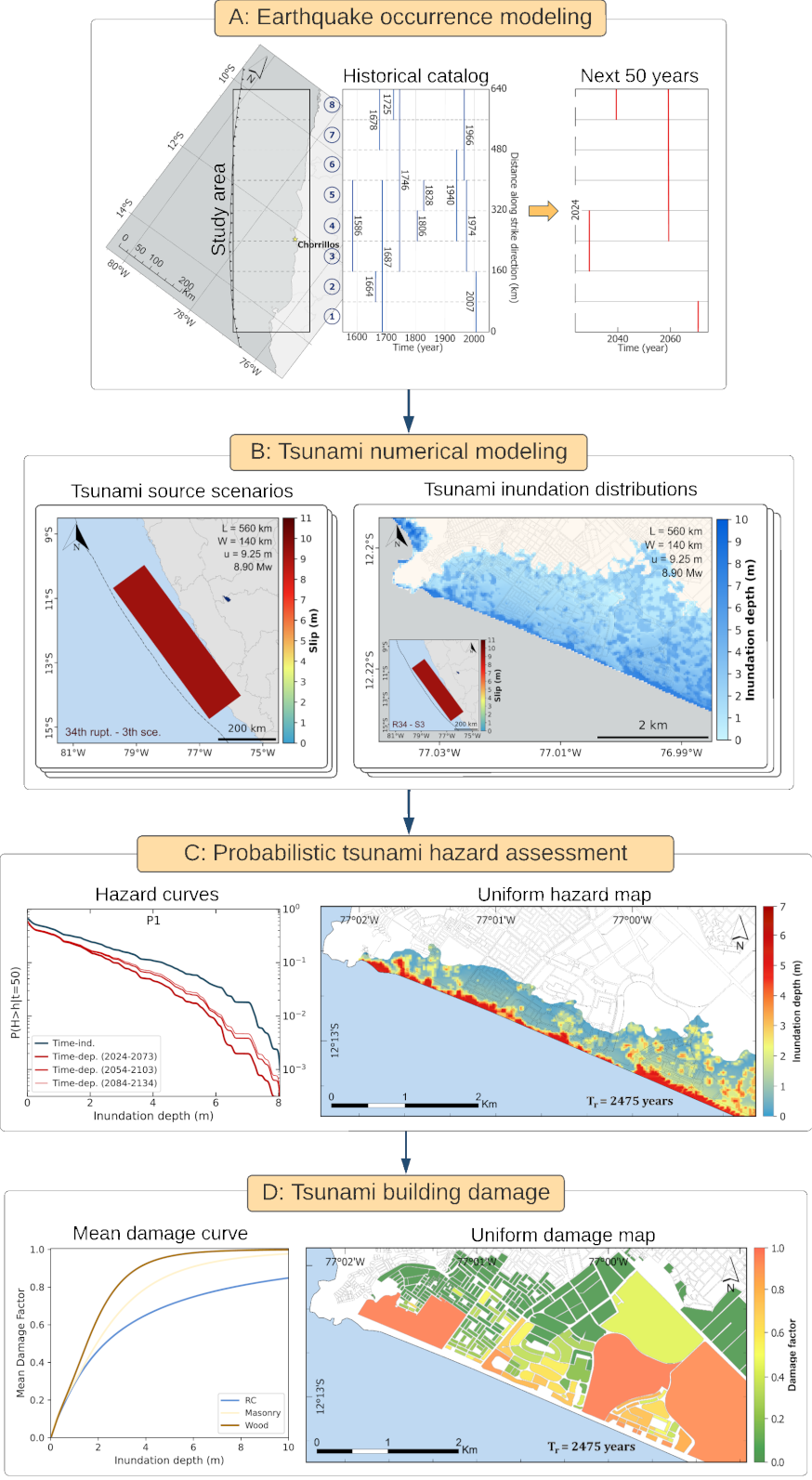
Tsunami risk-reduction measures must consider the full range of possible disaster outcomes and their probability of occurrence. This study conducted a probabilistic tsunami hazard assessment (PTHA) for the Chorrillos District using a probabilistic model that accounts for the time and space interactions of earthquake mainshocks. A total of 433 scenarios in the central Peruvian subduction zone within the range of Mw 7.5–9.0 were considered to develop tsunami hazard curves over the next 50 years and tsunami hazard maps for return periods of 475 and 2475 years. We further combined the tsunami hazard results and empirical tsunami fragility functions to assess building damage while accounting for construction materials. A time-independent analysis was implemented and compared with the spatiotemporal model to assess the influence of the seismic gap on tsunami hazards. The results revealed that the spatiotemporal model successfully captures the influence of seismic gaps on tsunami hazards. However, the time-independent analysis produces a higher tsunami hazard and greater building damage than the spatiotemporal model. This study is the first application of PTHA along the central Peruvian coast and can be implemented in tsunami hazard assessments for local communities across the northern, central, and southern regions of the Peruvian coastline.
PTHA framework
- [1] A. Grezio et al., “Probabilistic tsunami hazard analysis: Multiple sources and global applications,” Reviews of Geophysics, Vol.55, No.4, pp. 1158-1198, 2017. https://doi.org/10.1002/2017RG000579
- [2] J. Behrens et al., “Probabilistic tsunami hazard and risk analysis: A review of research gaps,” Frontiers in Earth Science, Vol.9, Article No.628772, 2021. https://doi.org/10.3389/feart.2021.628772
- [3] B. Gutenberg and C. F. Richter, “Seismicity of the Earth,” Geological Society of America Special Papers, No.34, 1941. https://doi.org/10.1130/SPE34
- [4] B. Gutenberg and C. F. Richter, “Frequency of earthquakes in California,” Bulletin of the Seismological Society of America, Vol.34, No.4, pp. 185-188, 1944. https://doi.org/10.1785/BSSA0340040185
- [5] T. Baba et al., “Probabilistic tsunami hazard assessment based on the Gutenberg–Richter law in eastern Shikoku, Nankai subduction zone, Japan,” Earth, Planets and Space, Vol.74, Article No.156, 2022. https://doi.org/10.1186/s40623-022-01715-1
- [6] R. Das et al., “A probabilistic seismic hazard assessment of southern Peru and northern Chile,” Engineering Geology, Vol.271, Article No.105585, 2020. https://doi.org/10.1016/j.enggeo.2020.105585
- [7] R. De Risi and K. Goda, “Probabilistic earthquake–tsunami multi-hazard analysis: Application to the Tohoku region, Japan,” Frontiers in Built Environment, Vol.2, Article No.25, 2016. https://doi.org/10.3389/fbuil.2016.00025
- [8] J. W. Baker, B. A. Bradley, and P. J. Stafford, “Seismic hazard and risk analysis,” Cambridge University Press, 2021. https://doi.org/10.1017/9781108425056
- [9] H. F. Reid, “The elastic-rebound theory of earthquakes,” Bulletin of the Department of Geology, Vol.6, pp. 413-444, 1910.
- [10] R. De Risi and K. Goda, “Simulation-based probabilistic tsunami hazard analysis: Empirical and robust hazard predictions,” Pure and Applied Geophysics, Vol.174, No.8, pp. 3083-3106, 2017. https://doi.org/10.1007/s00024-017-1588-9
- [11] K. Goda, “Time-dependent probabilistic tsunami hazard analysis using stochastic rupture sources,” Stochastic Environmental Research and Risk Assessment, Vol.33, No.2, pp. 341-358, 2019. https://doi.org/10.1007/s00477-018-1634-x
- [12] A. Muhammad, K. Goda, and M. J. Werner, “Time-dependent probabilistic tsunami hazard analysis for western Sumatra, Indonesia, using space-time earthquake rupture modelling and stochastic source scenarios,” Natural Hazards and Earth System Sciences Discussions (Preprint), 2022. https://doi.org/10.5194/nhess-2022-59
- [13] Y. Fukutani, S. Moriguchi, K. Terada, and Y. Otake, “Time-dependent probabilistic tsunami inundation assessment using mode decomposition to assess uncertainty for an earthquake scenario,” J. of Geophysical Research: Oceans, Vol.126, No.7, Article No.e2021JC017250, 2021. https://doi.org/10.1029/2021JC017250
- [14] K. Goda, “Probabilistic tsunami hazard analysis for Vancouver Island coast using stochastic rupture models for the Cascadia subduction earthquakes,” GeoHazards, Vol.4, No.3, pp. 217-238, 2023. https://doi.org/10.3390/geohazards4030013
- [15] H. B. Bayraktar and C. O. Sozdinler, “Probabilistic tsunami hazard analysis for Tuzla test site using Monte Carlo simulations,” Natural Hazards and Earth System Sciences, Vol.20, No.6, pp. 1741-1764, 2020. https://doi.org/10.5194/nhess-20-1741-2020
- [16] M. V. Matthews, W. L. Ellsworth, and P. A. Reasenberg, “A Brownian model for recurrent earthquakes,” Bulletin of the Seismological Society of America, Vol.92, No.6, pp. 2233-2250, 2002. https://doi.org/10.1785/0120010267
- [17] M. Ramos, R. Aránguiz, and M. T. Bull, “Tsunami inundation limit based on probabilistic analysis of runup and inundation distance,” Natural Hazards, Vol.121, No.3, pp. 2719-2745, 2025. https://doi.org/10.1007/s11069-024-06916-3
- [18] I. Becerra, R. Aránguiz, J. González, and R. Benavente, “An improvement of tsunami hazard analysis in Central Chile based on stochastic rupture scenarios,” Coastal Engineering J., Vol.62, No.4, pp. 473-488, 2020. https://doi.org/10.1080/21664250.2020.1812943
- [19] R. Aranguiz, M. Ramos, I. Sepúlveda, and P. Villagra, “A new generation of tsunami inundation maps of Chilean cities: Tsunami source database and probabilistic hazard analysis,” Coastal Engineering J., Vol.66, No.2, pp. 361-379, 2024. https://doi.org/10.1080/21664250.2024.2326269
- [20] N. Zamora and A. Y. Babeyko, “Probabilistic tsunami hazard assessment for local and regional seismic sources along the Pacific Coast of Central America with emphasis on the role of selected uncertainties,” Pure and Applied Geophysics, Vol.177, No.3, pp. 1471-1495, 2020. https://doi.org/10.1007/s00024-019-02372-4
- [21] J. C. Gomez-Zapata et al., “Variable-resolution building exposure modelling for earthquake and tsunami scenario-based risk assessment: An application case in Lima, Peru,” Natural Hazards and Earth System Sciences, Vol.21, No.11, pp. 3599-3628, 2021. https://doi.org/10.5194/nhess-21-3599-2021
- [22] E. Mas, B. Adriano, N. Pulido, C. Jimenez, and S. Koshimura, “Simulation of tsunami inundation in Central Peru from future megathrust earthquake scenarios,” J. Disaster Res., Vol.9, No.6, pp. 961-967, 2014. https://doi.org/10.20965/jdr.2014.p0961
- [23] B. Adriano et al., “Tsunami inundation mapping in Lima, for two tsunami source scenarios,” J. Disaster Res., Vol.8, No.2, pp. 274-284, 2013. https://doi.org/10.20965/jdr.2013.p0274
- [24] J. C. Tarazona et al., “Seismicity based maximum magnitude estimation of subduction earthquakes in Peru,” J. Disaster Res., Vol.18, No.4, pp. 308-318, 2023. https://doi.org/10.20965/jdr.2023.p0308
- [25] L. Dorbath, A. Cisternas, and C. Dorbath, “Assessment of the size of large and great historical earthquakes in Peru,” Bulletin of the Seismological Society of America, Vol.80, No.3, pp. 551-576, 1990. https://doi.org/10.1785/BSSA0800030551
- [26] J. C. Villegas-Lanza et al., “Active tectonics of Peru: Heterogeneous interseismic coupling along the Nazca megathrust, rigid motion of the Peruvian sliver, and Subandean shortening accommodation,” J. of Geophysical Research: Solid Earth, Vol.121, No.10, pp. 7371-7394, 2016. https://doi.org/10.1002/2016JB013080
- [27] L. Ceferino, A. Kiremidjian, and G. Deierlein, “Probabilistic space- and time-interaction modeling of mainshock earthquake rupture occurrence,” Bulletin of the Seismological Society of America, Vol.110, No.5, pp. 2498-2518, 2020. https://doi.org/10.1785/0120180220
- [28] F. Løvholt et al., “Global tsunami hazard and exposure due to large co-seismic slip,” Int. J. of Disaster Risk Reduction, Vol.10, Part B, pp. 406-418, 2014. https://doi.org/10.1016/j.ijdrr.2014.04.003
- [29] J. C. Martínez Herrera and S. I. Quisca Astocahuana, “Numerical modeling of tsunami in the city of Chorrillos, Lima—Peru,” Sustainable Development of Water and Environment: Proc. of the ICSDWE 2022, pp. 41-60, 2022. https://doi.org/10.1007/978-3-031-07500-1_4
- [30] National Institute of Statistics and Informatics (INEI), “Population estimates and projections by department, province, and district, 2018–2020,” 2020.
- [31] B. Adriano, E. Mas, S. Koshimura, M. Estrada, and C. Jimenez, “Scenarios of earthquake and tsunami damage probability in Callao region, Peru using tsunami fragility functions,” J. Disaster Res., Vol.9, No.6, pp. 968-975, 2014. https://doi.org/10.20965/jdr.2014.p0968
- [32] E. Mas, B. Adriano, and S. Koshimura, “An integrated simulation of tsunami hazard and human evacuation in La Punta, Peru,” J. Disaster Res., Vol.8, No.2, pp. 285-295, 2013. https://doi.org/10.20965/jdr.2013.p0285
- [33] E. Mas et al., “Identifying evacuees’ demand of tsunami shelters using agent based simulation,” Y. A. Kontar, V. Santiago-Fandiño, and T. Takahashi (Eds.), “Tsunami Events and Lessons Learned: Environmental and Societal Significance,” pp. 347-358, Springer, 2014. https://doi.org/10.1007/978-94-007-7269-4_19
- [34] C. B. Seoane Byrne, “Desigualdad social desde la perspectiva de proximidad a equipamientos prioritarios en el distrito de Chorrillos, Lima,” Investiga Territorios, No.9, pp. 35-43, 2019 (in Spanish).
- [35] K. Goda, “Multi-hazard portfolio loss estimation for time-dependent shaking and tsunami hazards,” Frontiers in Earth Science, Vol.8, Article No.592444, 2020. https://doi.org/10.3389/feart.2020.592444
- [36] L. Ceferino et al., “Bayesian parameter estimation for space and time interacting earthquake rupture model using historical and physics-based simulated earthquake catalogs,” Bulletin of the Seismological Society of America, Vol.111, No.6, pp. 3356-3373, 2021. https://doi.org/10.1785/0120210013
- [37] C. Jimenez et al., “Seismic source of 1746 Callao earthquake from tsunami numerical modeling,” J. Disaster Res., Vol.8, No.2, pp. 266-273, 2013. https://doi.org/10.20965/jdr.2013.p0266
- [38] E. Mas, B. Adriano, J. K. Horiuchi, and S. Koshimura, “Reconstruction process and social issues after the 1746 earthquake and tsunami in Peru: Past and present challenges after tsunami events,” V. Santiago-Fandiño, Y. A. Kontar, and Y. Kaneda (Eds.), “Post-Tsunami Hazard: Reconstruction and Restoration,” pp. 97-109, Springer, 2015. https://doi.org/10.1007/978-3-319-10202-3_7
- [39] C. Jimenez et al., “Estimation of the seismic source of the 1974 Lima Peru earthquake and tsunami (Mw 8.1),” J. Disaster Res., Vol.18, No.8, pp. 825-834, 2023. https://doi.org/10.20965/jdr.2023.p0825
- [40] H. Miura et al., “Assessment of site amplification factors in southern Lima, Peru based on microtremor H/V spectral ratios and deep neural network,” J. Disaster Res., Vol.18, No.4, pp. 298-307, 2023. https://doi.org/10.20965/jdr.2023.p0298
- [41] I. Inocente et al., “Earthquake damage assessment of buried pipeline networks in the Lima metropolitan area,” J. Disaster Res., Vol.18, No.4, pp. 366-378, 2023. https://doi.org/10.20965/jdr.2023.p0366
- [42] M. Diaz, C. Zavala, M. Estrada, and M. Matsuoka, “Characterization of the structural typologies of buildings in the Lima metropolitan area,” J. Disaster Res., Vol.18, No.4, pp. 329-337, 2023. https://doi.org/10.20965/jdr.2023.p0329
- [43] R. Jin, S. Wang, F. Yan, and J. Zhu, “Generating spatial correlated binary data through a copulas method,” Science Research, Vol.3, No.4, pp. 206-212, 2015. https://doi.org/10.11648/j.sr.20150304.18
- [44] L. Ceferino, A. Kiremidjian, and G. G. Deierlein, “Parameter estimation methods for modeling of time and space interactions of earthquake rupture,” 16th European Conf. on Earthquake Engineering, 2018.
- [45] B. C. Papazachos, E. M. Scordilis, D. G. Panagiotopoulos, C. B. Papazachos, and G. F. Karakaisis, “Global relations between seismic fault parameters and moment magnitude of earthquakes,” Bulletin of the Geological Society of Greece, Vol.36, No.3, pp. 1482-1489, 2004. https://doi.org/10.12681/bgsg.16538
- [46] Y. Okada, “Surface deformation due to shear and tensile faults in a half-space,” Bulletin of the Seismological Society of America, Vol.75, No.4, pp. 1135-1154, 1985. https://doi.org/10.1785/BSSA0750041135
- [47] S. Koshimura, Y. Namegaya, and H. Yanagisawa, “Tsunami fragility — A new measure to identify tsunami damage —,” J. Disaster Res., Vol.4, No.6, pp. 479-488, 2009. https://doi.org/10.20965/jdr.2009.p0479
- [48] A. Suppasri et al., “Building damage characteristics based on surveyed data and fragility curves of the 2011 Great East Japan tsunami,” Natural Hazards, Vol.66, No.2, pp. 319-341, 2013. https://doi.org/10.1007/s11069-012-0487-8
- [49] E. Mas et al., “Developing tsunami fragility curves using remote sensing and survey data of the 2010 Chilean tsunami in Dichato,” Natural Hazards and Earth System Sciences, Vol.12, No.8, pp. 2689-2697, 2012. https://doi.org/10.5194/nhess-12-2689-2012
- [50] S. Koshimura, T. Oie, H. Yanagisawa, and F. Imamura, “Developing fragility functions for tsunami damage estimation using numerical model and post-tsunami data from Banda Aceh, Indonesia,” Coastal Engineering J., Vol.51, No.3, pp. 243-273, 2009. https://doi.org/10.1142/S0578563409002004
- [51] K. Goda and J. Song, “Uncertainty modeling and visualization for tsunami hazard and risk mapping: A case study for the 2011 Tohoku earthquake,” Stochastic Environmental Research and Risk Assessment, Vol.30, No.8, pp. 2271-2285, 2016. https://doi.org/10.1007/s00477-015-1146-x
- [52] W. P. S. Dias and U. Edirisooriya, “Derivation of tsunami damage curves from fragility functions,” Natural Hazards, Vol.96, No.3, pp. 1153-1166, 2019. https://doi.org/10.1007/s11069-019-03601-8
- [53] J. Morales and M. Estrada, “Developing of a GIS tool to estimate the repair cost of buildings due to earthquake effects in Peru,” Tecnia, Vol.29, No.2, pp. 175-180, 2019. https://doi.org/10.21754/tecnia.v29i2.718
- [54] M. Kotani, F. Imamura, and N. Shuto, “Tsunami run-up simulation and damage estimation by using GIS,” Proc. of Coastal Engineering, JSCE, Vol.45, pp. 356-360, 1998 (in Japanese). https://doi.org/10.2208/proce1989.45.356
- [55] S. Koshimura, S. Hayashi, and H. Gokon, “Lessons from the 2011 Tohoku earthquake tsunami disaster,” J. Disaster Res., Vol.8, No.4, pp. 549-560, 2013. https://doi.org/10.20965/jdr.2013.p0549
- [56] O. Fujiwara, K. Goto, R. Ando, and E. Garrett, “Paleotsunami research along the Nankai Trough and Ryukyu Trench subduction zones – Current achievements and future challenges,” Earth-Science Reviews, Vol.210, Article No.103333, 2020. https://doi.org/10.1016/j.earscirev.2020.103333
- [57] G. P. Colchado, “Desentierran ruinas sumergidas en el Callao tras el tsunami de 1746: qué nos dicen los hallazgos sobre la vida del Perú en esa época,” El Comercio, March 15, 2024 (in Spanish). https://elcomercio.pe/lima/sucesos/una-capsula-del-tiempo-para-desenterrar-el-callao-sumergido-tras-el-tsunami-de-1746-fotos-historia-sitios-arquelogicos-real-felipe-peru-antiguo-area-sepultada-noticia/#google_vignette [Accessed September 22, 2025]
- [58] C. Davila et al., “Assessment of building vulnerability to tsunami in Ancon Bay, Peru, using high-resolution unmanned aerial vehicle imagery and numerical simulation,” Drones, Vol.9, No.6, Article No.402, 2025. https://doi.org/10.3390/drones9060402
This article is published under a Creative Commons Attribution-NoDerivatives 4.0 Internationa License.