Paper:
Tsunami Hazard and Exposure Assessment in Metropolitan Lima-Callao Under Historical and Plausible Seismic Scenarios
Angel Quesquen*,**
 , Miguel Estrada*,**,†
, Fernando Garcia*,**
, Carlos Davila*,**
, Brigitte Puchoc*,**
, and Shunichi Koshimura***
, Miguel Estrada*,**,†
, Fernando Garcia*,**
, Carlos Davila*,**
, Brigitte Puchoc*,**
, and Shunichi Koshimura***
*GeoGiRD Research Group, Facultad de Ingeniería Civil, Universidad Nacional de Ingeniería
Av. Tupac Amaru 1150, Rimac, Lima 15333, Peru
**Geomatics Laboratory, Centro Peruano Japonés de Investigaciones Sísmicas y Mitigación de Desastres
Lima, Peru
***International Research Institute of Disaster Science (IRIDeS), Tohoku University
Sendai, Japan
†Corresponding author

The impact of natural hazards can be effectively mitigated through preliminary assessments that combine geospatial and modeling approaches. Among these, tsunami exposure mapping plays a crucial role in coastal risk evaluation. This study develops a methodological framework for tsunami exposure assessment by integrating numerical simulation and geospatial analysis. Two tsunamigenic seismic scenarios were considered: (i) a historically documented event and (ii) a plausible large-magnitude earthquake off the Pacific coast of Lima, Peru. Tsunami propagation and inundation were simulated using the TUNAMI-N2 model to generate detailed inundation maps that delineate the spatial extent and inundation depth. The temporal evolution of tsunami impact distribution was analyzed using arrival-time maps and synthetic tide gauges, strategically located along the coastline to record wave amplitude variations over time. The population exposed to tsunami hazard was quantified using national census demographic data, while critical buildings were identified from official geospatial databases. This integration provides refined insights into tsunami hazard dynamics and supports evidence-based coastal risk management and urban growth.
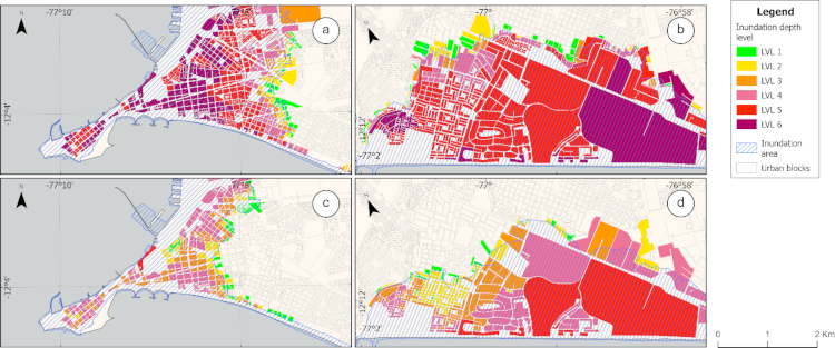
Urban blocks exposed to tsunami hazard
- [1] J. A. Reid and W. D. Mooney, “Tsunami occurrence 1900–2020: A global review, with examples from Indonesia,” Pure Appl. Geophys., Vol.180, No.5, pp. 1549-1571, 2023. https://doi.org/10.1007/s00024-022-03057-1
- [2] E. Norabuena et al., “Space geodetic observations of Nazca-South America convergence across the Central Andes,” Science, Vol.279, No.5349, pp. 358-362, 1998. https://doi.org/10.1126/science.279.5349.358
- [3] J. C. Gómez Zapata et al., “Scenario-based multi-risk assessment from existing single-hazard vulnerability models. An application to consecutive earthquakes and tsunamis in Lima, Peru,” Nat. Hazards Earth Syst. Sci., Vol.23, No.6, pp. 2203-2228, 2023. https://doi.org/10.5194/nhess-23-2203-2023
- [4] J. C. Gomez-Zapata et al., “Variable-resolution building exposure modelling for earthquake and tsunami scenario-based risk assessment: An application case in Lima, Peru,” Nat. Hazards Earth Syst. Sci., Vol.21, No.11, pp. 3599-3628, 2021. https://doi.org/10.5194/nhess-21-3599-2021
- [5] E. Silgado Ferro, “Historia de los sismos más notables ocurridos en el Perú (1513–1974),” Instituto de Geología y Minería, 1978 (in Spanish).
- [6] C. Jimenez et al., “Seismic source of 1746 Callao earthquake from tsunami numerical modeling,” J. Disaster Res., Vol.8, No.2, pp. 266-273, 2013. https://doi.org/10.20965/jdr.2013.p0266
- [7] Dirección Nacional de Prospectiva y Estudios Estratégicos, “Análisis del crecimiento y expansión urbana a nivel nacional y el impacto a nivel regional,” Centro Nacional de Planeamiento Estratégico (CEPLAN), 2023 (in Spanish).
- [8] L. Moya et al., “Brief communication: Radar images for monitoring informal urban settlements in vulnerable zones in Lima, Peru,” Nat. Hazards Earth Syst. Sci., Vol.22, No.1, pp. 65-70, 2022. https://doi.org/10.5194/nhess-22-65-2022
- [9] B. Adriano et al., “Tsunami inundation mapping in Lima, for two tsunami source scenarios,” J. Disaster Res., Vol.8, No.2, pp. 274-284, 2013. https://doi.org/10.20965/jdr.2013.p0274
- [10] E. Mas, B. Adriano, N. Pulido, C. Jimenez, and S. Koshimura, “Simulation of tsunami inundation in Central Peru from future megathrust earthquake scenarios,” J. Disaster Res., Vol.9, No.6, pp. 961-967, 2014. https://doi.org/10.20965/jdr.2014.p0961
- [11] F. Løvholt et al., “Global tsunami hazard and exposure due to large co-seismic slip,” Int. J. Disaster Risk Reduct., Vol.10, Part B, pp. 406-418, 2014. https://doi.org/10.1016/j.ijdrr.2014.04.003
- [12] A. Muhammad et al., “Are current tsunami evacuation approaches safe enough?,” Stoch. Environ. Res. Risk Assess., Vol.35, No.4, pp. 759-779, 2021. https://doi.org/10.1007/s00477-021-02000-5
- [13] E. Mas, B. Adriano, and S. Koshimura, “An integrated simulation of tsunami hazard and human evacuation in La Punta, Peru,” J. Disaster Res., Vol.8, No.2, pp. 285-295, 2013. https://doi.org/10.20965/jdr.2013.p0285
- [14] B. Adriano, E. Mas, S. Koshimura, M. Estrada, and C. Jimenez, “Scenarios of earthquake and tsunami damage probability in Callao Region, Peru using tsunami fragility functions,” J. Disaster Res., Vol.9, No.6, pp. 968-975, 2014. https://doi.org/10.20965/jdr.2014.p0968
- [15] Instituto Metropolitano de Planificación (IMP), “Catalogo de datos PLANMET 2040,” 2022 (in Spanish). https://portal.imp.gob.pe/sim/catalogo-de-datos-planmet-2040/ [Accessed February 2, 2025]
- [16] N. Pulido and J. C. Villegas-Lanza, “Mega-thrust earthquake potential along the subduction zone of Peru based on the earthquake energy-budget,” 28th General Assembly of the International Union of Geodesy and Geophysics, 2023. https://doi.org/10.57757/IUGG23-3817
- [17] A. M. O. Kamhawy, H. M. Hassan, and H. M. ElKosery, “Reappraisal of tsunami hazard for the Northern Coastal of Egypt considering sea level rise and delta subsidence scenarios,” Arab. J. Geosci., Vol.16, No.4, Article No.220, 2023. https://doi.org/10.1007/s12517-023-11304-5
- [18] Centro Nacional de Estimación, Prevención y Reducción del Riesgo de Desastres (CENEPRED), “Sistema de Información para la gestión del riesgo de desastres,” Sistema de Información para la Gestión del Riesgo de Desastres (SIGRID), 2024 (in Spanish). https://sigrid.cenepred.gob.pe/sigridv3/mapa [Accessed October 10, 2024]
- [19] J. León, C. Martínez, S. Inzunza, A. Ogueda, and A. Urrutia, “Improving tsunami risk analysis by integrating spatial resolution and the population’s evacuation capacities: A case study of Cartagena, Chile,” Int. J. Disaster Risk Sci., Vol.15, No.6, pp. 1001-1016, 2024. https://doi.org/10.1007/s13753-024-00607-0
- [20] R. Paulik, H. Craig, and B. Popovich, “A national-scale assessment of population and built-environment exposure in tsunami evacuation zones,” Geosciences, Vol.10, No.8, Article No.291, 2020. https://doi.org/10.3390/geosciences10080291
- [21] J. Raskin and Y. Wang, “Fifty-year resilience strategies for coastal communities at risk for tsunamis,” Nat. Hazards Rev., Vol.18, No.1, Article No.B4016003, 2017. https://doi.org/10.1061/(ASCE)NH.1527-6996.0000220
- [22] J. Cels et al., “Engineering surveys of Sri Lankan schools exposed to tsunami,” Front. Earth Sci., Vol.11, Article No.1075290, 2023. https://doi.org/10.3389/feart.2023.1075290
- [23] Global Alliance for Disaster Risk Reduction and Resilience in the Education Sector (GADRRRES), “Comprehensive school safety framework 2022–2030: For child rights and resilience in the education sector,” 2022.
- [24] Superintendencia Nacional de Salud (SUSALUD), “Registro Nacional de IPRESS - RENIPRESS,” 2025 (in Spanish).
- [25] MINEDU, “Padrón de servicios educativos,” 2024 (in Spanish).
- [26] Ministerio del Interior (MININTER), “Relación de comisarías básicas 2020,” 2020 (in Spanish).
- [27] Bomberos Voluntarios del Peru, “Ubicación de compañias y comandancias departamentales,” (in Spanish). https://www.bomberosperu.gob.pe/cgbvp_maps.asp [Accessed October 28, 2024]
- [28] Seacoast Office, Water and Disaster Management Bureau, Coast Division, River Department, National Institute for Land and Infrastructure Management, Ministry of Land, Infrastructure, Transport and Tourism (MLIT), “Guide to determining the potential tsunami inundation,” 2012.
- [29] Y. Yamamoto, H. Takanashi, S. Hettiarachchi, and S. Samarawickrama, “Verification of the destruction mechanism of structures in Sri Lanka and Thailand due to the Indian Ocean tsunami,” Coast. Eng. J., Vol.48, No.2, pp. 117-145, 2006. https://doi.org/10.1142/S0578563406001374
- [30] S. Koshimura, T. Oie, H. Yanagisawa, and F. Imamura, “Developing fragility functions for tsunami damage estimation using numerical model and post-tsunami data from Banda Aceh, Indonesia,” Coast. Eng. J., Vol.51, No.3, pp. 243-273, 2009. https://doi.org/10.1142/S0578563409002004
- [31] S. Widiyanto, D. Adi, N. Nurdin, and Fadila, “Agent-based simulation for evaluating the effect of different walking and driving speed on disaster evacuation in Aceh,” IPTEK J. Eng., Vol.7, No.2, pp. 50-58, 2021.
- [32] J. León et al., “Increasing resilience to catastrophic near-field tsunamis: Systems for capturing, modelling, and assessing vertical evacuation practices,” Nat. Hazards, Vol.120, No.10, pp. 9135-9161, 2024. https://doi.org/10.1007/s11069-022-05732-x
- [33] T. Takabatake, N. Hasegawa, K. Yamaguchi, and M. Esteban, “Comparative analysis of tsunami casualty estimation approaches: Agent-based modeling versus simplified approach in Japanese coastal cities,” Int. J. Disaster Risk Sci., Vol.15, No.5, pp. 719-737, 2024. https://doi.org/10.1007/s13753-024-00586-2
- [34] P. González-Riancho, B. Aliaga, S. Hettiarachchi, M. González, and R. Medina, “A contribution to the selection of tsunami human vulnerability indicators: Conclusions from tsunami impacts in Sri Lanka and Thailand (2004), Samoa (2009), Chile (2010) and Japan (2011),” Nat. Hazards Earth Syst. Sci., Vol.15, No.7, pp. 1493-1514, 2015. https://doi.org/10.5194/nhess-15-1493-2015
- [35] M. T. Ramírez-Herrera and J. A. Navarrete-Pacheco, “Satellite data for a rapid assessment of tsunami inundation areas after the 2011 Tohoku Tsunami,” Pure Appl. Geophys., Vol.170, No.6, pp. 1067-1080, 2013. https://doi.org/10.1007/s00024-012-0537-x
- [36] C. Davila et al., “Assessment of building vulnerability to tsunami in Ancon Bay, Peru, using high-resolution unmanned aerial vehicle imagery and numerical simulation,” Drones, Vol.9, No.6, Article No.402, 2025. https://doi.org/10.3390/drones9060402
- [37] M. Y. Rezaldi et al., “Unmanned aerial vehicle (UAV) and photogrammetric technic for 3D tsunamis safety modeling in Cilacap, Indonesia,” Appl. Sci., Vol.11, No.23, Article No.11310, 2021. https://doi.org/10.3390/app112311310
- [38] A. Androsov, S. Harig, N. Zamora, K. Knauer, and N. Rakowsky, “Nonlinear processes in tsunami simulations for the Peruvian coast with focus on Lima and Callao,” Nat. Hazards Earth Syst. Sci., Vol.24, No.5, pp. 1635-1656, 2024. https://doi.org/10.5194/nhess-24-1635-2024
- [39] National Institute of Statistics and Informatics (INEI), “Peru: Total Population Projections by Department, Province, and District, 2018–2022,” 2022.
- [40] CENEPRED, “Escenario de riesgo por sismo y tsunami para Lima y Callao,” 2020 (in Spanish). https://sigrid.cenepred.gob.pe/sigridv3/storage/biblioteca//10354_escenario-de-riesgo-por-sismo-y-tsunami-para-lima-y-callao.pdf [Accessed February 12, 2025]
- [41] The United Nations Office for Disaster Risk Reduction (UNISDR), “Sendai framework for disaster risk reduction 2015–2030,” 2015.
- [42] Presidencia del Consejo de Ministros (PCM), “Politica nacional de gestion del riesgo de desastres al 2050,” Gobierno del Peru, Presidencia del Consejo de Ministros, 2021 (in Spanish).
This article is published under a Creative Commons Attribution-NoDerivatives 4.0 Internationa License.