Paper:
Multi-Sensing Data-Based Estimation of Isolated Settlements During Disasters: A Case Study Using the 2024 Noto Peninsula Earthquake
Shono Fujita†
 , Satomi Kimijima
, Habura Borjigin, Makoto Hanashima, Shingo Toride
, and Hitoshi Taguchi
, Satomi Kimijima
, Habura Borjigin, Makoto Hanashima, Shingo Toride
, and Hitoshi Taguchi
National Research Institute for Earth Science and Disaster Resilience (NIED)
3-1 Tennodai, Tsukuba, Ibaraki 305-0006, Japan
†Corresponding author

In the event of a disaster, the occurrence of isolated settlements necessitates prompt responses, including rescue operations, medical transport, and the delivery of essential supplies. However, it is often challenging to quickly identify which areas are isolated. This study developed a method for estimating isolated settlements during earthquake disasters using multi-sensing data. An accuracy evaluation based on data from the 2024 Noto Peninsula earthquake revealed an overlook rate of approximately 60% and a mistaken estimation rate of approximately 20%. By incorporating actual road traffic data, the estimation was refined to extract settlements at high risk of isolation. Moreover, the method successfully identified isolated settlements that were not reported in official damage reports, indicating relatively high estimation accuracy. This capability is expected to assist disaster management headquarters in identifying priority areas for emergency response. Because the data used in the proposed method can be obtained during actual disaster events, the estimation process can be initiated promptly across Japan immediately after an earthquake, thereby enabling the timely provision of valuable information for disaster response. This analysis presents the necessary data and computational approaches for improving estimation accuracy and supporting practical implementation in disaster management. In the future, advancements in various sensing technologies and the development of data-sharing frameworks are expected to facilitate even more accurate estimations.
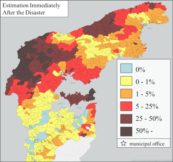
Estimation results of isolation probabilities
- [1] Central Disaster Management Council, “Japanese basic disaster management plan,” (in Japanese). https://www.bousai.go.jp/taisaku/keikaku/pdf/kihon_basicplan.pdf [Accessed May 2, 2025]
- [2] Ishikawa Prefecture, “Damage report,” (in Japanese). https://www.pref.ishikawa.lg.jp/saigai/202401jishin-taisakuhonbu.html#higai [Accessed May 2, 2025]
- [3] J. F. Sortino Barrionuevo, H. Castro Noblejas, and F. J. Cantarero Prados, “Vulnerability to flood risk: A methodological proposal for assessing the isolation of the population,” Land, Vol.11, No.2, Article No.277, 2022. https://doi.org/10.3390/land11020277
- [4] S. Harada, Y. Eitoku, T. Tone, S. Miki, and H. Wakabayashi, “Practical evaluation about the connection reliability of road,” J. of Japan Society of Civil Engineers, Ser. D3 (Infrastructure Planning and Management), Vol.69, No.5, pp. I_67-I_74, 2013 (in Japanese). https://doi.org/10.2208/jscejipm.69.I_67
- [5] H. Sakakibara, Y. Kajitani, and N. Okada, “Road network robustness for avoiding functional isolation in disasters,” J. of Transportation Engineering, Vol.130, No.5, pp. 560-567, 2004. https://doi.org/10.1061/(ASCE)0733-947X(2004)130:5(560)
- [6] N. Sheng, Y. Jia, Z. Xu, S.-L. Ho, and C. W. Kan, “A complex network based model for detecting isolated communities in water distribution networks,” Chaos, Vol.23, Article No.043102, 2013. https://doi.org/10.1063/1.4823803
- [7] K. Yoshida, S. Shiozawa, Y. Tanaka, and K. Hoshikawa, “Evaluation of villages isolation risk by using 50 m mesh elevation data,” Water, Land and Environmental Engineering, Vol.75, No.11, pp. 967-970, 2007 (in Japanese). https://doi.org/10.11408/jjsidre2007.75.967
- [8] A. Nakasuji, “Landslide hazard mapping during a large scale earthquake,” J. of Mountain Science, Vol.8, No.2, pp. 223-227, 2011. https://doi.org/10.1007/s11629-011-2089-4
- [9] Director General for Disaster Management, “Follow-up survey on the potential for isolated settlements in scattered communities in mountainous and hilly areas,” 2014 (in Japanese). https://www.bousai.go.jp/jishin/chihou/pdf/20141022-koritsuhoukokusyo.pdf [Accessed May 2, 2025]
- [10] S.-M. Hsu and T.-L. Chen, “Resilience assessment of mountain settlements isolation effects in extreme climate change,” Proc. of REAL CORP 2022; 27th Int. Conf. on Urban Planning and Regional Development in the Information Society, pp. 993-1000, 2022.
- [11] S. Kondo et al., “A study of prediction isolated district map focused on road blockade,” Proc. of the 32th JSCE Earthquake Engineering Symp., 2012 (in Japanese).
- [12] Y. Ono and S. Hongo, “Quantificative analysis of isolation possibility during earthquake in mountainous area,” J. of Japan Society of Civil Engineers Ser. A1 (Structural Engineering & Earthquake Engineering (SE/EE)), Vol.74, No.4, pp. I_313-319, 2018 (in Japanese). https://doi.org/10.2208/jscejseee.74.I_313
- [13] W.-C. Wang, M.-C. Hsieh, and C.-H. Huang, “Applying Prim’s algorithm to identify isolated areas for natural disaster prevention and protection,” Engineering, Vol.10, No.7, pp. 417-431, 2018. https://doi.org/10.4236/eng.2018.107029
- [14] Y. Ono and K. Hibi, “Evaluation of isolation risk in mountainous region considering road blockages caused by earthquake-induced slope failures: Application to 2004 Niigata-ken Chuetsu and 2016 Kumamoto Earthquakes,” J. of Japan Association for Earthquake Engineering, Vol.19, No.6, pp. 232-243, 2019 (in Japanese). https://doi.org/10.5610/jaee.19.6_232
- [15] B. Yang, M. Kim, C. Lee, S. Hwang, and J. Choi, “Developing an automated analytical process for disaster response and recovery in communities prone to isolation,” Int. J. of Environmental Research and Public Health, Vol.19, No.21, Article No.13995, 2022. https://doi.org/10.3390/ijerph192113995
- [16] “Subgroup A, wide-area and rapid detection and sharing of disaster information of the 3rd phase of the Cross-ministerial Strategic Innovation Promotion Program (SIP),” (in Japanese). https://risk.bosai.go.jp/ [Accessed May 2, 2025]
- [17] “Cross-ministerial Strategic Innovation Promotion Program (SIP): Development of a resilient smart network system against natural disasters,”(in Japanese). https://www.nied-sip3.bosai.go.jp/index.html [Accessed May 2, 2025]
- [18] Disaster Management, Cabinet Office, Government of Japan, “Working group on countermeasures for a massive earthquake along the Japan Trench and Kuril Trench (5th meeting),” 2021 (in Japanese). https://www.bousai.go.jp/jishin/nihonkaiko_chishima/WG/pdf/dai5kai/siryo2.pdf [Accessed May 2, 2025]
- [19] National Research Institute for Earth Science and Disaster Resilience, “Japan real-time information system for earthquake,” (in Japanese). https://www.j-risq.bosai.go.jp/report/ [Accessed May 2, 2025]
- [20] S. Naito et al., “Development of functional enhancements and a utilization of the real-time damage estimation system (J-RISQ) – Effort toward the multi-hazard risk assessment –,” Technical Note of the National Research Institute for Earth Science and Disaster Resilience, No.485, 2023 (in Japanese).
- [21] Road dataset of ArcGIS Geo Suite package (in Japanese). https://www.esrij.com/products/data-content-geosuite-douromo/ [Accessed May 2, 2025]
- [22] Ministry of Agriculture, Forestry and Fisheries, “Agricultural settlement boundaries of the agricultural census,” (in Japanese). https://www.maff.go.jp/j/tokei/census/shuraku_data/2020/ma/ [Accessed May 2, 2025]
- [23] Ministry of Agriculture, Forestry and Fisheries, “The fisheries settlement boundaries of the fisheries census,” (in Japanese). https://www.maff.go.jp/j/tokei/census/fc/database/mapdata/index.html [Accessed May 2, 2025]
- [24] Japan Geographic Data Center, “District boundary database,” (in Japanese). https://www.kokudo.or.jp/database/013.html [Accessed May 2, 2025]
- [25] TomTom, “Traffic data & traffic stats,” https://www.tomtom.com/products/traffic-stats/ [Accessed May 2, 2025]
- [26] The Sankei Shimbun, “Noto Island isolated as both bridges connecting the island become impassable,” January 2, 2024 (in Japanese). https://www.sankei.com/article/20240102-7MKDFPSIFBIQPIHSLPKSH6RVNI/ [Accessed May 2, 2025]
- [27] Y. Usuda, M. Hanashima, R. Sato, and H. Sano, “Effects and issues of information sharing system for disaster response,” J. Disaster Res., Vol.12, No.5, pp. 1002-1014, 2017. https://doi.org/10.20965/jdr.2017.p1002
This article is published under a Creative Commons Attribution-NoDerivatives 4.0 Internationa License.